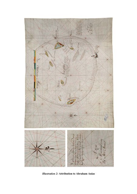
Illustration 2: Attribution to Abraham <strong>An</strong>ias
The Gentlemen Seventeen, <strong>the</strong> highest authority board <strong>of</strong> <strong>the</strong> VOC, were careful that <strong>the</strong> maps and navigational equipment issued to navigation <strong>of</strong>ficers sent to <strong>the</strong> <strong>East</strong> Indies were returned and not discarded or sold to outsiders. In order to better exercise control over <strong>the</strong>se tools, experts in <strong>the</strong> field <strong>of</strong> navigation compiled lists <strong>of</strong> <strong>the</strong> necessary <strong>chart</strong>s and instruments. The lists (first handwritten, later printed) include a detailed overview <strong>of</strong> <strong>the</strong> instruments and cartographical material that were allocated, followed by <strong>the</strong> price <strong>of</strong> each item as determined by <strong>the</strong> <strong>Company</strong>. Each <strong>of</strong> <strong>the</strong> navigational <strong>of</strong>ficers (skipper, first steersman, and two second steersmen) had to sign <strong>the</strong> inventory upon receipt and was required to return all <strong>the</strong> material upon completing <strong>the</strong> journey to Batavia. In <strong>the</strong> event <strong>of</strong> missing or mishandled <strong>chart</strong>s, <strong>the</strong>y were fined an amount equal to twice <strong>the</strong> list price <strong>of</strong> <strong>the</strong> item in question. These lists were drawn up for <strong>the</strong> first time in 1655, and were regularly revised and adapted to navigational developments. Thus, for example, <strong>the</strong> lists <strong>of</strong> 1675, 1731 and 1747 were all improved. As <strong>of</strong> 1663 <strong>the</strong> lists were printed in order to avoid <strong>the</strong>ir frequent copying, so that only <strong>the</strong> names <strong>of</strong> <strong>the</strong> ship, ship’s <strong>of</strong>ficer and <strong>the</strong> date had to be filled in by hand. The printed list for <strong>the</strong> Zeeland Chamber that specifies <strong>the</strong> books, <strong>chart</strong>s and nautical instruments gives us a detailed insight <strong>of</strong> <strong>the</strong> equipment on board <strong>of</strong> an <strong>East</strong> <strong>India</strong>man <strong>of</strong> that period (ill. 4). Today <strong>the</strong>se lists are invaluable sources for our knowledge and understanding <strong>of</strong> <strong>the</strong> navigational equipment used by VOC vessels in <strong>the</strong> seventeenth and eighteenth centuries, and <strong>the</strong>y allow us to reconstruct <strong>the</strong> kind and number <strong>of</strong> <strong>chart</strong>s used. Thus, we now know that three or four sets <strong>of</strong> <strong>chart</strong>s were used for navigating from Zeeland to Batavia. While <strong>the</strong> list <strong>of</strong> 1675 refers almost exclusively to <strong>manuscript</strong> <strong>chart</strong>s, <strong>the</strong> revised list <strong>of</strong> 1731 includes <strong>the</strong> first mention <strong>of</strong> <strong>the</strong> printed <strong>chart</strong>s which Johannes (II) van Keulen had only recently been permitted to supply to VOC ships. The much more expensive <strong>manuscript</strong> <strong>chart</strong>s were usually drawn on <strong>vellum</strong>, a sturdy material which was less prone to damage from climate and moisture as well as wear and tear. These <strong>chart</strong>s were never folded, after use <strong>the</strong>y were rolled up and stored in large tin containers. The contract between <strong>the</strong> Zeeland Chamber and Abraham <strong>An</strong>ias formalised that he had to supply all <strong>East</strong> <strong>India</strong>men <strong>of</strong> <strong>the</strong> Chamber with <strong>the</strong> necessary books, <strong>chart</strong>s and nautical instruments, as far as <strong>the</strong>y were not in local stock with <strong>the</strong> <strong>Company</strong>. In <strong>the</strong> first half <strong>of</strong> <strong>the</strong> 18th century, <strong>the</strong> majority <strong>of</strong> <strong>manuscript</strong> <strong>chart</strong>s on <strong>vellum</strong> was produced by <strong>the</strong> Amsterdam Chamber, i.e. Isaac de Graaf (1705-43) and his assistants. The Amsterdam Chamber also equipped <strong>the</strong> o<strong>the</strong>r five chambers with <strong>vellum</strong> <strong>chart</strong>s. Zeeland was <strong>the</strong> only o<strong>the</strong>r Chamber with a <strong>chart</strong>-making workshop. It was <strong>the</strong> responsibility <strong>of</strong> Abraham <strong>An</strong>ias to provide for <strong>chart</strong>s that were lacking at <strong>the</strong> Zeeland Chamber, by drawing <strong>the</strong>m in his own hand. Whereas worldwide eight <strong>vellum</strong> <strong>chart</strong>s <strong>of</strong> <strong>the</strong> <strong>India</strong>n Ocean are known by Isaac de Graaf, only one single o<strong>the</strong>r example has come to us from <strong>the</strong> hand <strong>of</strong> Abraham <strong>An</strong>ias (The Hague National Archives). This fact emphasizes <strong>the</strong> great significance and rarity <strong>of</strong> <strong>the</strong> item <strong>of</strong>fered here. Closer inspection <strong>of</strong> <strong>the</strong> 1731 list <strong>of</strong> <strong>chart</strong>s reveals that two different groups <strong>of</strong> <strong>chart</strong>s can be distinguished. One group consists <strong>of</strong> small-scale <strong>chart</strong>s that cover large parts <strong>of</strong> <strong>the</strong> area between Texel and Batavia, whereas <strong>the</strong> o<strong>the</strong>r group contains <strong>the</strong> large-scale <strong>chart</strong>s <strong>of</strong> small regions that are essential to navigate <strong>the</strong> difficult waters around Holland, <strong>the</strong> English Channel, <strong>the</strong> treacherous coasts around <strong>the</strong> Cape, and <strong>the</strong> navigation <strong>of</strong> <strong>the</strong> waters near Australia and <strong>the</strong> Indonesian Archipelago.