Blue Ridge Park way - Massanutten Resort
Blue Ridge Park way - Massanutten Resort
Blue Ridge Park way - Massanutten Resort

You also want an ePaper? Increase the reach of your titles
YUMPU automatically turns print PDFs into web optimized ePapers that Google loves.
81<br />
Wytheville<br />
Austinville<br />
Ivanhoe<br />
Woodlawn<br />
58<br />
200<br />
52<br />
77<br />
Cana Mount<br />
Airy<br />
89<br />
94<br />
Fries<br />
221<br />
Galax<br />
97 210<br />
White Plains<br />
<strong>Blue</strong> <strong>Ridge</strong><br />
Music Center<br />
74<br />
601<br />
Bottom<br />
89 Low Gap Dobson<br />
21<br />
274 Baywood 18<br />
Cumberland Knob<br />
220<br />
77<br />
Longs Gap<br />
Edmonds<br />
State<br />
Road<br />
Independence<br />
Roaring<br />
21 Ennice<br />
Gap<br />
21<br />
Bridle Creek<br />
221 Sparta<br />
230<br />
To<br />
Elkin<br />
58<br />
Stone Mtn.<br />
93 White<br />
State <strong>Park</strong><br />
Head<br />
240<br />
16 Volney<br />
Brinegar Cabin<br />
Piney Creek<br />
Mouth<br />
Doughton <strong>Park</strong><br />
Citron<br />
of Wilson<br />
Rugby<br />
113 250<br />
16<br />
268<br />
Grayson<br />
221<br />
McGrady<br />
Highlands<br />
S.P.<br />
88<br />
18 Halls Mills<br />
Shatley<br />
Northwest Trading<br />
Fairplains<br />
194 Springs<br />
Glendale Post<br />
North Wilkesboro<br />
Springs 260<br />
Warrensville<br />
Jefferson<br />
16<br />
Wilkesboro<br />
Wilbar<br />
163<br />
West<br />
E.B. Jeffress<br />
Moravian Falls<br />
Jefferson<br />
<strong>Park</strong><br />
Beaver Creek Fleetwood 270<br />
N<br />
Trade<br />
To<br />
Bristol<br />
TN<br />
NC<br />
N. Fork New R.<br />
Ashland<br />
88 Todd<br />
Cane R.<br />
421<br />
Toe River<br />
New R.<br />
194<br />
S. Fork<br />
VA<br />
NC<br />
221<br />
221<br />
Deep Gap<br />
Laxon<br />
Boone<br />
268<br />
Darby<br />
MAP KEY: Refer to page 13 for explanation of symbols<br />
421<br />
<strong>Blue</strong> <strong>Ridge</strong><br />
<strong>Park</strong><strong>way</strong><br />
W. Kerr Scott<br />
Reservoir<br />
Ferguson<br />
Villas<br />
290<br />
Yadkin<br />
321<br />
Valle Crucis 105<br />
Julian Price<br />
Memorial <strong>Park</strong><br />
Blowing Rock 321<br />
Moses H. Cone<br />
Memorial <strong>Park</strong><br />
Valley<br />
To<br />
Hickory<br />
300<br />
Lenoir<br />
Banner Elk<br />
18<br />
Sugar Mountain 184<br />
194<br />
Elk <strong>Park</strong> Linville<br />
Roan<br />
194<br />
Mtn. 19E<br />
Newland<br />
Cranberry<br />
Pineola<br />
19E<br />
To<br />
Linn Cove Viaduct<br />
Collettsville<br />
90<br />
Rhodhiss<br />
Lake<br />
310<br />
90<br />
Jonas <strong>Ridge</strong><br />
Linville Falls<br />
181 Morganton<br />
Elizabethton<br />
261<br />
194<br />
Table Rock<br />
Buladean Ingalls 320 Linville Falls<br />
Ashford Glen<br />
Bakersville<br />
Spruce<br />
Alpine<br />
221 126<br />
40<br />
226<br />
Ledger<br />
226 Pine<br />
Lake<br />
Museum of<br />
330 James<br />
Red Hill North Carolina<br />
Little<br />
Nebo<br />
197 80 Minerals<br />
Switzerland<br />
Woodlawn<br />
226<br />
Micaville<br />
Crabtree Meadows<br />
Burnsville<br />
340<br />
226<br />
ALT<br />
80<br />
Marion<br />
19W<br />
197<br />
Murchison<br />
Cane River<br />
Mount Mitchell 128<br />
Swiss State <strong>Park</strong><br />
350<br />
Pleasant<br />
Gardens<br />
70 0<br />
0<br />
221<br />
5 mi<br />
5 km<br />
19<br />
23<br />
Mars<br />
Hill<br />
Barnardsville<br />
Craggy Gardens<br />
Old Fort<br />
360<br />
40<br />
Montreat <strong>Ridge</strong>crest<br />
Black Mountain<br />
9<br />
26<br />
370 To Asheville<br />
280<br />
18<br />
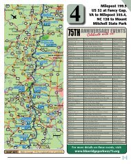
4Map 4<br />
216.9<br />
217.5<br />
218.6<br />
229<br />
Milepost 199.5<br />
US 52 at Fancy Gap,<br />
VA to Milepost 355.4,<br />
NC 128 to Mount<br />
Mitchell State <strong>Park</strong><br />
NC - VA State Line. Alt. 2,547.<br />
Cumberland Knob. 1,000 acres, picnic area, comfort<br />
stations, drinking water. 15-minute loop trail to<br />
Cumberland Knob. (Elev. 2,855). Loop trail into Gully<br />
Creek Gorge. 2 hours.<br />
Fox Hunters Paradise. Overlook and parking area.<br />
A one-minute walk on a paved trail takes you to a<br />
rock pedestrian overlook near the spot where oldtime<br />
hunters listened to their hounds. Alt. 2,805.<br />
US 21 Crossover. West 7 mi. to Sparta, NC., 17 mi<br />
to Independence, VA. East 4 Mi. to Roaring Gap, NC.<br />
ALLEGHANY CoUNTY, NC<br />
Alleghany County Visitor Center is just a few miles off the BRP in<br />
downtown Sparta. Slow down. Breathe easy. Stay as busy or unbusy<br />
as you want to be. Conquer a mountain or play checkers on<br />
the front porch. Find out where to stay, dine, hike, explore, canoe,<br />
fish, shop and play. www.sparta-nc.com (800) 376-5473.<br />
GLADE VALLEY, NC<br />
North of the <strong>Park</strong><strong>way</strong> via US 21, exit at MP 229.<br />
<strong>Blue</strong> <strong>Ridge</strong> B & B - at MP 225/226, 5905 Mtn View Rd. 28627.<br />
Homestyle feel, comfy rooms, easy access off BRP, full breakfast,<br />
internet, satellite TV, VI/MC. www.blueridgebandb.net<br />
(336) 657-3000.<br />
Glade Valley B & B - 1.5 miles from MP 229 at Rt. 21. A custom designed<br />
log home w/private baths, views & great homemade country<br />
breakfast. www.gladevalley.com or call (800) 538-3508.<br />
JoNESVILLE, NC<br />
Exit at Milepost 229, South of <strong>Park</strong><strong>way</strong> on US 21, via I-77 South,<br />
Exit 82. Welcome Center open Mon-Sat. 8:30am-8:00pm, Sun 12-<br />
8:00pm. www.visittheyadkinvalley.com (877) 728-6798.<br />
SPARTA, NC<br />
North of <strong>Park</strong><strong>way</strong> on US 21. Exit at MP 229 or 248.<br />
Alleghany Inn - 341 N Main St, Sparta, NC 28675. 64 Rooms - Free<br />
Wireless Internet - Cable TV 60+ chan, guest laundry. Restaurant<br />
on site. Reserve online: www.AlleghanyInn.com or (888) 372-2501.<br />
49