Blue Ridge Park way - Massanutten Resort
Blue Ridge Park way - Massanutten Resort
Blue Ridge Park way - Massanutten Resort

Create successful ePaper yourself
Turn your PDF publications into a flip-book with our unique Google optimized e-Paper software.
Banner Elk<br />
Sugar Mountain<br />
184<br />
105<br />
To Boone<br />
Collettsville<br />
194<br />
Linville Linn Cove Viaduct<br />
19E<br />
Elk <strong>Park</strong> 194<br />
Cranberry Newland<br />
Pineola<br />
Roan Mtn. 19E<br />
90<br />
To<br />
Jonas 181 Morganton<br />
<strong>Ridge</strong> Linville Falls<br />
Table<br />
261<br />
To<br />
Elizabethton<br />
194 Linville Falls<br />
320<br />
Rock<br />
Ingalls<br />
Buladean <strong>Blue</strong> <strong>Ridge</strong> <strong>Park</strong><strong>way</strong><br />
Spruce<br />
226<br />
Ledger Pine<br />
Bakersville<br />
Museum of<br />
Bandana North Carolina<br />
Red Hill<br />
Minerals<br />
80<br />
Ashford<br />
221<br />
126<br />
Lake<br />
330 James<br />
Little<br />
Switzerland<br />
Woodlawn<br />
Micaville<br />
197<br />
Burnsville<br />
Crabtree<br />
Meadows<br />
340<br />
226<br />
ALT<br />
80<br />
Marion<br />
Pleasant<br />
80<br />
Gardens<br />
19W<br />
To<br />
Johnson<br />
City<br />
Swiss<br />
19E<br />
Cane<br />
River<br />
Murchison<br />
Mount Mitchell<br />
State <strong>Park</strong><br />
350<br />
128<br />
70<br />
Old<br />
Fort<br />
N<br />
310<br />
TN<br />
NC<br />
French Broad R.<br />
Pigeon R.<br />
460<br />
Cherokee 19<br />
Indian<br />
Res. Oconaluftee<br />
Cane R.<br />
Toe River<br />
26<br />
23<br />
19<br />
Buckner<br />
197<br />
Barnardsville<br />
360<br />
Montreat<br />
40<br />
<strong>Ridge</strong>crest<br />
Mars Hill<br />
23<br />
19<br />
213<br />
Stocksville<br />
Craggy<br />
Gardens<br />
26<br />
Black 9<br />
370 Mountain<br />
Folk Art<br />
To<br />
Center<br />
Chimney<br />
Rock<br />
Swannanoa<br />
Weaverville<br />
70<br />
25<br />
Alexander<br />
Walnut Marshall 251<br />
380<br />
Oteen<br />
25<br />
ALT<br />
74<br />
<strong>Park</strong><strong>way</strong><br />
Visitor Center<br />
Asheville<br />
Skyland<br />
390 Arden<br />
Spring<br />
Creek<br />
Canto<br />
63<br />
Leicester<br />
191<br />
26<br />
Candler Lake<br />
Trust<br />
209<br />
Luther<br />
Powhatan 400 Mills<br />
River<br />
40<br />
Mt. Pisgah<br />
To<br />
Knoxville 209<br />
Crabtree<br />
Canton<br />
Stoney<br />
<strong>Park</strong><br />
281<br />
40<br />
Lake<br />
410<br />
276 Cruso<br />
Brevard<br />
Junaluska<br />
215<br />
Great<br />
276<br />
Smoky<br />
Mountains Dellwood<br />
Waynesville<br />
Sunburst<br />
National<br />
<strong>Park</strong><br />
Waterrock<br />
Knob<br />
Hazelwood<br />
440<br />
Maggie Valley<br />
430<br />
276<br />
420<br />
Balsam<br />
Grove<br />
215<br />
450<br />
23<br />
74<br />
Balsam<br />
Highest Point on<br />
<strong>Park</strong><strong>way</strong> 6047ft<br />
Southern End <strong>Blue</strong> <strong>Ridge</strong> <strong>Park</strong><strong>way</strong><br />
2020ft 2020ft Sylva<br />
Tuckasegee<br />
107<br />
Cherokee<br />
Dillsboro<br />
Cullowhee<br />
107<br />
19<br />
Glenville<br />
To<br />
Franklin<br />
281<br />
0<br />
0<br />
Tuckasegee R.<br />
5 km<br />
MAP KEY: Refer to page 13 for explanation of symbols<br />
64<br />
5 mi<br />
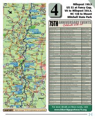
5Map 5<br />
Milepost 305.2,<br />
US 221 at<br />
Grandfather Mountain to<br />
Milepost 412.2<br />
CRoSSNoRE, NC<br />
6 miles south of Linville off Hwy 221, exit at Milepost 305.9 or<br />
312.<br />
Crossnore Weavers & Gallery - “A working museum.” Traditional<br />
hand woven textiles produced since 1920. Open Mon-Sat. Off Hwy<br />
221 in Crossnore. (800) 374-4660. www.crossnoreweavers.org<br />
316.3<br />
316.4<br />
317.4<br />
Linville Falls. Visitor Center. Campground and<br />
picnic area. Trail to overlooks of falls and gorge.<br />
For camping reservations www.recreation.gov.<br />
Linville River <strong>Park</strong>ing Area. One of the <strong>Park</strong><strong>way</strong>’s<br />
largest stone arch bridges. Three spans of 80 feet<br />
each. Fish in Linville River. Picnic area. Comfort<br />
Station. Alt. 3,250. Take Spur Rd. to Linville Falls,<br />
campground and visitor center.<br />
South 1 mi. to Linville Falls community.<br />
24 mi. to Marion.<br />
LINVILLE FALLS, NC<br />
1 mile south of <strong>Park</strong><strong>way</strong> on US 221, exit at MP 317.4.<br />
ATTRACTIoNS<br />
Linville Caverns - North Carolina’s only show caverns. Open daily<br />
March thru November, Dec.-Jan.-Feb. weekends only. Courteous,<br />
experienced guides, outstanding gift shop. Located on US 221<br />
between Linville and Marion, just 4 miles south of the <strong>Park</strong><strong>way</strong>-<br />
Exit <strong>Park</strong><strong>way</strong> at Milepost 317.4. Turn left on US 221 toward Linville<br />
Falls and Marion. Email: info@linvillecaverns.com (800) 419-0540.<br />
www.linvillecaverns.com<br />
FooD, LoDGING, & CAMPING<br />
Cross Creek Cabins - Five cozy log cabins, 2 miles from<br />
<strong>Park</strong><strong>way</strong>, MP 315. 1, 2, & 3 bedrooms, open all year and pet<br />
friendly. Quiet, peaceful, with ponds, creek, and walking distance<br />
to Linville “water” Falls & gorge entrance. M/C & Visa.<br />
www.crosscreekcabins.com (828) 765-9701.<br />
The Inn At <strong>Blue</strong> <strong>Ridge</strong> - MP 317.4 - 5 mi South on Hwy<br />
221. A beautiful Bed & Breakfast. 12 large rooms with fireplace,<br />
refrigerator, private deck & adjacent to golf course.<br />
www.theinnatblueridge.com (828) 756-7001 toll free<br />
(866) 756-7001.<br />
61