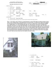
Chico Mud Creek Drainage District (CSA 24) - City of Chico
Chico Mud Creek Drainage District (CSA 24) - City of Chico
Chico Mud Creek Drainage District (CSA 24) - City of Chico

You also want an ePaper? Increase the reach of your titles
YUMPU automatically turns print PDFs into web optimized ePapers that Google loves.
Source: Butte County LAFCO, 2005.<br />
A Division <strong>of</strong><br />
FIGURE 4.3-2C<br />
<strong>Chico</strong> <strong>Mud</strong> <strong>Creek</strong> <strong>Drainage</strong> <strong>District</strong> (<strong>CSA</strong> <strong>24</strong>)<br />
D51061.00<br />
NORTH<br />
<strong>Chico</strong> MSR
Source: Butte County LAFCO, 2005.<br />
A Division <strong>of</strong><br />
FIGURE 4.3-2D<br />
Shasta Union <strong>Drainage</strong> <strong>District</strong> (<strong>CSA</strong> 25)<br />
D50961-00<br />
NORTH<br />
SCALE IN<br />
<strong>Chico</strong> MSR
Municipal Service Review<br />
P:\Projects ‐ WP Only\51061.00 <strong>Chico</strong> MSR\Final MSR\4.3 Storm <strong>Drainage</strong>.doc<br />
4.3 Storm <strong>Drainage</strong><br />
Map (FIRM) for unincorporated Butte County shows Sacramento River overflow inundating an area<br />
about two miles east <strong>of</strong> the river boundaries. The volume <strong>of</strong> water within this two‐mile backwater area<br />
would be expected to increase over time with additional urban run<strong>of</strong>f associated with growth, as well as<br />
from natural drainage. 10<br />
Capacities <strong>of</strong> channels in the western portion <strong>of</strong> the <strong>City</strong> are also limited, and potential flood flows are<br />
believed to be higher than recorded historical occurrences. The FIRM also shows floodwater flowing out<br />
<strong>of</strong> the Big <strong>Chico</strong> <strong>Creek</strong> Channel near the western edge <strong>of</strong> the <strong>City</strong>. Inadequate channel capacity<br />
exacerbates the flooding potential near the Sacramento River. Flood control projects on Little <strong>Chico</strong><br />
<strong>Creek</strong>, Big <strong>Chico</strong> <strong>Creek</strong>, and Lindo Channel have helped reduce the amount <strong>of</strong> run<strong>of</strong>f that flows through<br />
the <strong>City</strong>, reducing potential flooding problems.<br />
The Department <strong>of</strong> Water Resources is responsible for maintenance <strong>of</strong> the Sycamore‐<strong>Mud</strong> <strong>Creek</strong>‐Sandy<br />
Gulch channels. The Department <strong>of</strong> Water Resources maintains the Little <strong>Chico</strong> <strong>Creek</strong> Diversion and<br />
Butte <strong>Creek</strong> levees with funding through State Maintenance Area 5. The <strong>City</strong> <strong>of</strong> <strong>Chico</strong> and Department<br />
<strong>of</strong> Water Resources share responsibility for maintenance <strong>of</strong> the Little <strong>Chico</strong> <strong>Creek</strong> channel. By agreement<br />
with the Department <strong>of</strong> Water Resources, Butte County only maintains the Sycamore‐<strong>Mud</strong> <strong>Creek</strong>‐Sandy<br />
Gulch levees and structures. Funding for this maintenance is provided by <strong>CSA</strong> <strong>24</strong>. Butte County does<br />
not maintain flood control channels. The M&T diversion from Butte <strong>Creek</strong> to Comanche <strong>Creek</strong> is a<br />
private facility and is maintained and operated by the M&T Ranch. 11<br />
Determination 4.3-4<br />
Urban development along waterways and encroachment on floodplains creates flooding problems in the<br />
<strong>City</strong> and in the agricultural area west <strong>of</strong> the <strong>City</strong>. Storm drainage system improvements identified in the<br />
Storm <strong>Drainage</strong> Master Plan (SDMP) address these flooding issues.<br />
� Funding and Fees<br />
The majority <strong>of</strong> the storm drainage collection system located within <strong>City</strong> limits is operated and<br />
maintained by the <strong>City</strong> General Services Department, O&M Division. Maintenance <strong>of</strong> facilities within<br />
the <strong>City</strong> is funded primarily from the General Fund. Storm drainage collection facilities located outside<br />
the <strong>City</strong> limits are typically maintained by the County Department <strong>of</strong> Public Works. Flood control<br />
improvements within the <strong>City</strong> are maintained primarily by the County. Funding for storm drainage<br />
facilities and infrastructure typically depends on the location <strong>of</strong> the structure. Funding for <strong>CSA</strong>s No. 22,<br />
23, and 25 is only for the operation and maintenance <strong>of</strong> the facilities constructed as part <strong>of</strong> the original<br />
assessment districts. <strong>CSA</strong> funding does not provide for maintenance <strong>of</strong> new, primarily subdivision‐<br />
related storm drainage facilities that connect to the original assessment district facilities.<br />
10 <strong>City</strong> <strong>of</strong> <strong>Chico</strong>, General Plan, November 1994, Updated September 1999.<br />
11 <strong>City</strong> <strong>of</strong> <strong>Chico</strong>, Storm <strong>Drainage</strong> Master Plan Environmental Impact Report, October 2000.<br />
4.3-15
Chapter 4. Infrastructure Needs and Deficiencies<br />
The <strong>City</strong> levies a Storm Drain Development Impact Fee (Fund 309) authorized by Chapter 3.85.405 <strong>of</strong> the<br />
<strong>Chico</strong> Municipal Code. The purpose <strong>of</strong> the fee is to provide funding for the construction and expansion<br />
<strong>of</strong> the <strong>City</strong>’s storm drain system to accommodate the needs <strong>of</strong> projected new growth. It also provides<br />
funding as indicated in the “2000 <strong>City</strong> <strong>of</strong> <strong>Chico</strong> Storm <strong>Drainage</strong> Master Plan Integrated Document” for<br />
peak attenuation facilities (storm water detained in detention ponds), water quality facilities, and data<br />
collection facilities. 12<br />
The maintenance and repair <strong>of</strong> diversion structures, levees, and access roads that were constructed as<br />
part <strong>of</strong> the U.S. Army Corps <strong>of</strong> Engineers Big <strong>Chico</strong> <strong>Creek</strong>, Sycamore <strong>Creek</strong>, <strong>Mud</strong> <strong>Creek</strong>, Sandy Gulch,<br />
and Lindo Channel improvement projects are funded by <strong>CSA</strong> No. <strong>24</strong>, administered by the County<br />
Department <strong>of</strong> Public Works. Open ditches and other facilities in <strong>CSA</strong>s 22, 23, and 25 are also<br />
maintained by the County with funds generated within the <strong>CSA</strong>s.<br />
4.3.2 Plans and Regulatory Requirements<br />
� National Pollutant Discharge Elimination System<br />
The National Pollutant Discharge Elimination System (NPDES) permit system was established in the<br />
Clean Water Act (CWA) to regulate municipal and industrial discharge to surface waters <strong>of</strong> the U.S.<br />
Each NPDES permit contains limits on allowable concentrations and mass emissions <strong>of</strong> pollutants<br />
contained in the discharge. The permit would require the municipal authority to evaluate the quality <strong>of</strong><br />
its stormwater discharge and receiving waters, identify areas <strong>of</strong> pollutant loading, and implement a<br />
program <strong>of</strong> BMPs to control pollutant discharges to the maximum extent practicable. It is within the<br />
existing authority <strong>of</strong> the CVRWQCB to issue a NPDES permit for any stormwater outfall that discharges<br />
to the waters in the region.<br />
Discharges from municipal separate storm sewer systems (“MS4s”) in urbanized areas are regulated<br />
because <strong>of</strong> concern over the high concentration <strong>of</strong> pollutants found in those discharges. Phase I <strong>of</strong> the<br />
stormwater program, which addresses run<strong>of</strong>f from these sources, began in 1990. Additional federal<br />
legislation, referred to as the Storm Water Phase II program, has been promulgated under the NPDES<br />
program to include small municipalities with populations <strong>of</strong> 1,000 to 100,000. The Phase II program<br />
expands the existing Phase I program by requiring additional owners and operators <strong>of</strong> small MS4s in<br />
urbanized areas (and construction sites), through the use <strong>of</strong> NPDES permits, to implement programs and<br />
practices to control polluted stormwater run<strong>of</strong>f.<br />
The <strong>City</strong> has been identified as one that is required to comply with NPDES Phase II permitting because it<br />
has been identified as an “Urbanized Area” by the Bureau <strong>of</strong> Census. Both the <strong>City</strong> and County are part<br />
<strong>of</strong> the NPDES Phase II permit requirements for the <strong>Chico</strong> Urbanized Area. Both jurisdictions have<br />
permits and have been working cooperatively to comply with State and federal requirements. In the<br />
<strong>City</strong>, the County <strong>of</strong> Butte, <strong>City</strong> <strong>of</strong> <strong>Chico</strong>, <strong>Chico</strong> Unified School <strong>District</strong>, and California State University,<br />
<strong>Chico</strong> are required to develop a storm water management program that implements six minimum<br />
measures focusing on a Best Management Practice (BMP) approach. The BMPs chosen by the operators<br />
<strong>of</strong> the MS4s should be designed to reduce pollutants in urban storm water compared to existing levels in<br />
12 <strong>City</strong> <strong>of</strong> <strong>Chico</strong>, Department <strong>of</strong> Public Works, 2004‐05 Updates <strong>of</strong> Development Impact Fees Analysis and Recommendations (Nexus Study),<br />
November 2, 2004, p. vi.<br />
4.3-16<br />
<strong>City</strong> <strong>of</strong> <strong>Chico</strong>
Municipal Service Review<br />
P:\Projects ‐ WP Only\51061.00 <strong>Chico</strong> MSR\Final MSR\4.3 Storm <strong>Drainage</strong>.doc<br />
4.3 Storm <strong>Drainage</strong><br />
a cost‐effective manner. BMPs include public education, treatment practices, operating procedures, and<br />
practices to control site run<strong>of</strong>f, spillage, or leaks.<br />
NPDES permits are issued for five‐year terms and generally follow a progressive pattern.<br />
To meet NPDES Phase II permit requirements, the <strong>City</strong> submitted a Storm Water Management Program<br />
(SWMP) along with a MS4 NPDES Storm Water Permit Application to the CVRWQCB to obtain a permit.<br />
The SWMP presents strategies, goals, priorities, and management activities for years 2003 to 2008 to<br />
prevent pollutants from entering the storm drainage system. The objectives <strong>of</strong> the SWMP are to provide<br />
guidance to the public and businesses, and act as a coordinating entity towards a cohesive storm water<br />
program. An NPDES Phase II SWMP must meet six minimum controls, use best management practices<br />
(BMPs) to the maximum extent practicable, and achieve measurable goals. In the first five years <strong>of</strong> the<br />
program, the focus is on establishing a program customized to local conditions using the following six<br />
minimum measures:<br />
1. Public education and outreach;<br />
2. Public participation/involvement;<br />
3. Construction site run<strong>of</strong>f control;<br />
4. Post‐construction run<strong>of</strong>f control;<br />
5. Pollution prevention/good housekeeping; and<br />
6. Program Evaluation Activities.<br />
Future permits will be issued based on using the knowledge gained during the first five‐year permitting<br />
and putting it to work on improving water quality incrementally over time.<br />
� Federal Emergency Management Agency<br />
The Federal Emergency Management Agency (FEMA) administers the National Flood Insurance<br />
Program (NFIP) to provide subsidized flood insurance to communities complying with FEMA<br />
regulations that limit developments in floodplains. FEMA is the main federal government agency contact<br />
during natural disasters and publishes Flood Insurance Rate Maps (FIRM), which identify the extent <strong>of</strong><br />
flood potential in flood prone communities based on a 100‐year flood (or base flood) event.<br />
The NFIP regulations permit development within special flood hazard zones provided that residential<br />
structures are raised above the base flood elevation <strong>of</strong> a 100‐year flood event. Non‐residential structures<br />
are required either to provide flood pro<strong>of</strong>ing construction techniques for that portion <strong>of</strong> structures below<br />
the 100‐year flood elevation or to elevate above the 100‐year flood elevation. The regulations also apply<br />
to substantial improvements <strong>of</strong> existing structures.<br />
� <strong>City</strong> <strong>of</strong> <strong>Chico</strong> General Plan Policies<br />
The General Plan encourages use <strong>of</strong> natural drainage techniques and provides policies to ensure<br />
provision <strong>of</strong> adequate drainage facilities. The three‐pronged strategy governing the policies that follow<br />
includes:<br />
■ Use <strong>of</strong> natural drainage and reduced storm water flow techniques where feasible;<br />
■ Incorporation <strong>of</strong> storm‐water detention facilities for projects draining into Little <strong>Chico</strong> and<br />
Comanche <strong>Creek</strong>s; and<br />
4.3-17
Chapter 4. Infrastructure Needs and Deficiencies<br />
4.3-18<br />
■ Provision <strong>of</strong> filtration system for all drainages in the <strong>City</strong>.<br />
The Parks and Public Services, Open Space, and Safety elements <strong>of</strong> the <strong>City</strong> <strong>of</strong> <strong>Chico</strong> General Plan<br />
contain guiding principles, goals, and policies related to drainage. Issues addressed include funding,<br />
maintenance, run<strong>of</strong>f, and flood control. Applicable key storm drainage policy statements from the<br />
General Plan are presented below:<br />
Parks and Public Services Element<br />
PP‐Implementation‐37: Continue exploring alternatives to stormwater collection methods, including the<br />
use <strong>of</strong> detention/retention basins and the feasibility <strong>of</strong> a ʺno net run<strong>of</strong>fʺ concept for the entire urban area.<br />
PP‐Implementation‐38: Use porous materials (e.g. porous asphalt, modular paving, gravel, lattice<br />
concrete blocks and porous bricks) for outdoor spaces, paving, and sidewalks, where feasible.<br />
PP‐Implementation‐39: Establish storm‐water run‐<strong>of</strong>f reduction standards for projects larger than five<br />
acres and incentives for ʺzero‐netʺ stormwater run<strong>of</strong>f, such as reduced storm drainage impact fees.<br />
PP‐Implementation‐40: Delineate urban areas draining to Little <strong>Chico</strong> and Comanche creeks, and require<br />
storm‐water detention for all projects draining to these creeks. Require no net increase in peak<br />
stormwater run<strong>of</strong>f.<br />
PP‐Implementation‐41: Explore the feasibility <strong>of</strong> an area‐wide rate structure to fund storm water<br />
drainage and ongoing maintenance. Require all new development to pay this fee as a condition <strong>of</strong><br />
project approval.<br />
PP‐Implementation‐42: Ensure that new development has a minimal impact on natural drainage<br />
channels and flow capacity.<br />
PP‐Implementation‐43: Continue requiring project proponents to provide plans for erosion and<br />
sedimentation control from their sites during construction.<br />
PP‐Implementation‐44: Undertake maintenance efforts, in cooperation with the County, to ensure that<br />
channels that convey surface drainage are not blocked.<br />
PP‐Implementation‐62: Use resource‐based standards for transportation facilities, parks, water,<br />
wastewater, and drainage facilities and police and fire service established in Table 5.6‐1 as a basis for<br />
decision on applications for major development projects.<br />
PP‐Implementation‐63: Continue to require that new development pay its fair share <strong>of</strong> costs associated<br />
with providing streets and facilities for police and fire protection, parks, wastewater treatment, and<br />
drainage.<br />
Open Space Element<br />
OS‐Guiding‐12: Where feasible, given flood control requirements, maintain the natural condition <strong>of</strong><br />
waterways and flood plains and protect watersheds to ensure adequate<br />
groundwater recharge and water quality.<br />
OS‐Guiding‐15: Preserve and enhance <strong>Chico</strong>ʹs creeks and the riparian corridors adjacent to them as open<br />
space corridors for the visual amenity, drainage, fisheries, wildlife<br />
habitats, flood control and water quality value.<br />
Safety Element<br />
S‐Guiding‐1: Minimize threat to life and property from flooding and dam inundation.<br />
S‐Implementation‐1: As part <strong>of</strong> project review, ensure that structures subject to the 100‐year flood<br />
provide adequate protection from flood hazards.<br />
S‐Implementation‐2: When considering areas for future urban expansion ensure that impacts <strong>of</strong> flooding<br />
are adequately analyzed.<br />
<strong>City</strong> <strong>of</strong> <strong>Chico</strong>
Municipal Service Review<br />
P:\Projects ‐ WP Only\51061.00 <strong>Chico</strong> MSR\Final MSR\4.3 Storm <strong>Drainage</strong>.doc<br />
4.3 Storm <strong>Drainage</strong><br />
S‐Implementation‐3: In designing flood control facilities, consider the need to protect anadromous<br />
fisheries and allow for adequate water passage to ensure the survival <strong>of</strong> downstream riparian<br />
ecosystems.<br />
In accordance with the requirements <strong>of</strong> the General Plan, a Best Practices Manual (BPM) and Best<br />
Practices Technical Manual (BPTM) have been prepared by the <strong>City</strong>. These manuals are a compilation <strong>of</strong><br />
existing <strong>City</strong> guidelines, codes, policies, programs, and standardized mitigation measures pertaining to<br />
General Plan policies that are best implemented via the documents included in these manuals (e.g., storm<br />
drainage systems). The manuals also incorporate the regulatory standards <strong>of</strong> other federal, State, and<br />
regional agencies, as appropriate. Regulations, guidelines, and standards specific to storm drainage<br />
include General Plan policies, Standard Mitigation and Monitoring Program, Best Management Practices<br />
(Water Quality), Grading Standards, Erosion Control Standardized Notes, Pertinent CalTrans Contract<br />
Specifications, and CVRWQB Construction Stormwater Permit. 13<br />
� <strong>City</strong> <strong>of</strong> <strong>Chico</strong> Storm <strong>Drainage</strong> Master Plan<br />
The <strong>City</strong> <strong>of</strong> <strong>Chico</strong> has adopted a Storm <strong>Drainage</strong> Master Plan (SDMP) in September 2000 that identifies<br />
the public storm drain improvements necessary to serve a major portion <strong>of</strong> the <strong>City</strong> at buildout. The<br />
specific objectives <strong>of</strong> the SDMP are to:<br />
■ Develop a consistent set <strong>of</strong> planning criteria;<br />
■ Update and modify existing storm drainage studies;<br />
■ Prepare a preliminary storm drain master plan for all pipes larger than 18 inches in diameter;<br />
■ Develop planning level cost estimates for required improvements;<br />
■ Identify topographic or other data requirements needed for future drainage planning;<br />
■ Collect more precise definition <strong>of</strong> appropriate design high water elevations in the creeks;<br />
■ Implement a computer model <strong>of</strong> the system;<br />
■ Provide peak flow attenuation in Comanche and Little <strong>Chico</strong> <strong>Creek</strong>s;<br />
■ Provide channel stabilization in all waterways in the urban area; and<br />
■ Implement BMPs to minimize water quality impacts throughout the <strong>City</strong>.<br />
The SDMP identifies specific projects to improve existing storm drainage and to provide drainage<br />
facilities for future development. The drainage facilities would include replacement <strong>of</strong> existing pipes,<br />
placement <strong>of</strong> new pipes, installation <strong>of</strong> pump stations, construction <strong>of</strong> peak flow attenuation facilities<br />
(detention basins), bank stabilization facilities, stormwater quality facilities, and design and data<br />
collection programs. In particular, peak attenuation facilities would be constructed in the Comanche<br />
<strong>Creek</strong> and Little <strong>Chico</strong> <strong>Creek</strong> Urban <strong>Drainage</strong> Basins. The specific size and design <strong>of</strong> individual facilities<br />
would vary. Each project would adhere to standards, performance criteria, and design criteria consistent<br />
with the SDMP, the SDMP Addendum, and the General Plan, as adopted by the <strong>City</strong> Council and as<br />
amended to reflect advances in policy, technology, or engineering practice. 14<br />
13 <strong>City</strong> <strong>of</strong> <strong>Chico</strong>, Storm Drain Master Plan and Addendum, Executive Summary, 1997, p. 4.<br />
14 <strong>City</strong> <strong>of</strong> <strong>Chico</strong>, Storm <strong>Drainage</strong> Master Plan Environmental Impact Report, October 2000.<br />
4.3-19
Chapter 4. Infrastructure Needs and Deficiencies<br />
Municipal Code<br />
Title 15 <strong>of</strong> the <strong>City</strong> <strong>of</strong> <strong>Chico</strong> Municipal Code requires all rainwater, storm drainage, or other water which<br />
is not required to be conveyed to the <strong>City</strong>’s sanitary sewer system or private sewage disposal system to<br />
be conveyed to the <strong>City</strong>’s storm drainage system or drainage channel. If it is determined by the Director<br />
<strong>of</strong> Engineering that storm drainage cannot be conveyed to the <strong>City</strong>’s system, the Director may authorize<br />
a temporary leachfield‐type storm drainage system.<br />
4.3.3 Anticipated Demand and Planned Improvements<br />
Planned and funded improvements to the <strong>City</strong>’s stormwater drainage system are contained in the <strong>City</strong>’s<br />
2005/06 CIP. Design and construction <strong>of</strong> storm drainage facilities are planned at Elm Street between 21 st<br />
and 22 nd Streets and at Stilson Canyon and Humboldt Roads. Reconstruction <strong>of</strong> East 5 th Avenue will<br />
include improvements to the existing storm drainage system from The Esplanade to SR 99.<br />
� Northwest <strong>Chico</strong> Specific Plan (NCSP)<br />
An existing storm drainage system in the NCSP conveys storm water from the Plan Area and<br />
contributing <strong>of</strong>fsite areas into <strong>Mud</strong> and Sycamore <strong>Creek</strong>s. The existing Shasta Union <strong>Drainage</strong><br />
Assessment <strong>District</strong> (SUDAD) Channel is the primary drainage channel through which stormwater<br />
run<strong>of</strong>f from the Plan Area travels to <strong>Mud</strong> <strong>Creek</strong>. The SUDAD system, designed in 1964, to primarily<br />
serve rural uses is comprised <strong>of</strong> several open lined and unlined channels that function as a gravity<br />
system. The existing SUDAD system is owned, operated, and maintained by Butte County and is<br />
anticipated to remain under the County’s jurisdiction after development <strong>of</strong> the NCSP.<br />
The NCSP EIR analyzed two alternative drainage systems to <strong>of</strong>fset the impacts <strong>of</strong> increased run<strong>of</strong>f<br />
volume and peak flow volumes. Alternative 1 would use an <strong>of</strong>f‐site parcel, adjacent to the southwest<br />
corner <strong>of</strong> the Plan Area and <strong>Mud</strong> <strong>Creek</strong>, to accommodate drainage detention. This area would also<br />
function as a wetland restoration project, with water quality treatment features. This alternative would<br />
also include a second drainage detention facility west <strong>of</strong> Highway 99 that would serve as a neighborhood<br />
park with the capacity to provide 18 acre‐feet <strong>of</strong> water storage. Pipes would range from 30 inches to 66<br />
inches and would be designed to carry the flow from a 10‐year event.<br />
The second alternative would have three detention facilities located on the west side <strong>of</strong> Highway 99.<br />
Alternative 2 includes the same drainage facility (detention basin) that would serve as a neighborhood<br />
park and provide 18 acre‐feet <strong>of</strong> water storage as Alternative 1. Alternative 2 also includes a detention<br />
basin in a park area along <strong>Mud</strong> <strong>Creek</strong> which would provide 2.5 acre‐feet <strong>of</strong> storage along with another<br />
detention facility to the south that would provide another approximately 9 acre‐feet <strong>of</strong> storage. A new<br />
storm drain parallel to <strong>Mud</strong> <strong>Creek</strong> would carry outflows from these detention basins as well as run<strong>of</strong>f<br />
generated from most development west <strong>of</strong> Powerline Drive. The storm drain system would consist <strong>of</strong><br />
pipes <strong>of</strong> varying sizes, from 30 to 66 inches, and would drain by gravity.<br />
Both Alternative 1 and Alternative 2 drainage plans would result in some minor flooding; however, there<br />
would be an improvement over existing conditions. The NCSP EIR concluded Alternative 1 was the<br />
preferred drainage plan.<br />
4.3-20<br />
<strong>City</strong> <strong>of</strong> <strong>Chico</strong>
Determination 4.3-5<br />
Municipal Service Review<br />
P:\Projects ‐ WP Only\51061.00 <strong>Chico</strong> MSR\Final MSR\4.3 Storm <strong>Drainage</strong>.doc<br />
4.3 Storm <strong>Drainage</strong><br />
The Northwest <strong>Chico</strong> Specific Plan includes stormwater drainage facilities that would accommodate<br />
increased run<strong>of</strong>f volume and peak flow volumes from that project.<br />
� Funding and Fees<br />
The <strong>City</strong> and County would continue to operate, maintain, and fund the facilities for which they are<br />
currently responsible. Maintenance and operation funding comes from the General Fund and <strong>CSA</strong>s.<br />
As a result <strong>of</strong> new development occurring on residential and nonresidential property located within the<br />
<strong>City</strong>, the <strong>City</strong> is required to make substantial improvements to the <strong>City</strong>’s storm drainage system. The<br />
<strong>City</strong>’s Five‐Year Capital Improvement Program (CIP) identifies $3.1 million in improvements from the<br />
Storm <strong>Drainage</strong> Facility fund (Fund 309) across four projects. The two storm drain facilities projects that<br />
have funding are the Stilson Canyon/Humboldt Road Storm Drain and the 22 nd Street and Elm Street<br />
Storm Drain. A list <strong>of</strong> planned storm drainage system improvement expenditures from FY 2005/06<br />
through FY 2009/10 are summarized in Table 4.3‐1.<br />
Table 4.3-1 Summary <strong>of</strong> CIP Expenditures for Storm <strong>Drainage</strong> System Improvements<br />
Fiscal Year<br />
Project Description Fund 2005/06 2006/07 2007/08 2008/09 2009/10 TOTAL<br />
Annual Nexus Study Update 309 8,348 8,348 8,348 8,348 8,348 41,740<br />
Stilson Canyon/Humboldt Rd Storm Drain 309 70,528 0 0 0 0 70,528<br />
22nd St and Elm St Storm Drain 309 97,440 0 0 0 0 97,440<br />
E. 5th Ave Reconstruction 309 69,600 0 2,850,000 0 0 2,919,600<br />
TOTAL <strong>24</strong>5,916 8,348 2,858,348 8,348 8,348 3,129,308<br />
Determination 4.3-6<br />
Maintenance <strong>of</strong> storm drainage facilities within the <strong>City</strong> is funded primarily from the General Fund. The<br />
CIP identifies $3.1 million in improvements to the <strong>City</strong>’s storm drainage system over the course <strong>of</strong> five<br />
years from 2005/2006 to 2009/2010.<br />
4.3.4 Summary <strong>of</strong> Written Determinations<br />
4.3‐1 Stormwater run<strong>of</strong>f in the <strong>City</strong> is collected and conveyed by storm drainage systems operated and<br />
maintained by the <strong>City</strong> and County. Existing storm drainage system improvements are effectively<br />
managed and operate with sufficient capacity to accommodate flows. Planned improvements to ensure<br />
future flows are effectively managed and operated have been identified in the SDMP.<br />
4.3-21
Chapter 4. Infrastructure Needs and Deficiencies<br />
4.3‐2 The <strong>City</strong> has prepared and implemented a Storm Water Management Program (SWMP) to minimize<br />
run<strong>of</strong>f and prevent pollutants from entering the storm drainage system.<br />
4.3‐3 Four County Service Areas (<strong>CSA</strong>s) to facilitate the provision and funding <strong>of</strong> necessary drainage facilities<br />
for portions <strong>of</strong> both incorporated and unincorporated areas. Two <strong>of</strong> the <strong>CSA</strong>s in the <strong>City</strong>’s SOI (<strong>CSA</strong> 22<br />
and 23) will be fully within the <strong>City</strong> limits following current annexation activities. Approximately 65<br />
percent <strong>of</strong> <strong>CSA</strong> 25 will be in the <strong>City</strong> limits. A mechanism for transfer <strong>of</strong> existing funding for<br />
maintenance <strong>of</strong> these <strong>CSA</strong>s is still being developed. Approximately one third <strong>of</strong> the <strong>CSA</strong> <strong>24</strong> is outside the<br />
<strong>City</strong> SOI, and the timeline and mechanism detachment/dissolution has not yet been determined.<br />
4.3‐4 Urban development along waterways and encroachment on floodplains creates flooding problems in the<br />
<strong>City</strong> and in the agricultural area west <strong>of</strong> the <strong>City</strong>. Storm drainage system improvements identified in the<br />
Storm <strong>Drainage</strong> Master Plan (SDMP) address these flooding issues.<br />
4.3‐5 The Northwest <strong>Chico</strong> Specific Plan includes stormwater drainage facilities that would accommodate<br />
increased run<strong>of</strong>f volume and peak flow volumes from that project.<br />
4.3‐6 Maintenance <strong>of</strong> storm drainage facilities within the <strong>City</strong> is funded primarily from the General Fund. The<br />
CIP identifies $3.1 million in improvements to the <strong>City</strong>’s storm drainage system over the course <strong>of</strong> five<br />
years from 2005/2006 to 2009/2010.<br />
4.3-22<br />
<strong>City</strong> <strong>of</strong> <strong>Chico</strong>