2009 Biennial (PDF, 12 MB) - Applied Physics Laboratory-University ...
2009 Biennial (PDF, 12 MB) - Applied Physics Laboratory-University ...
2009 Biennial (PDF, 12 MB) - Applied Physics Laboratory-University ...

Create successful ePaper yourself
Turn your PDF publications into a flip-book with our unique Google optimized e-Paper software.
ingeniouS reSearcH PlatFormS<br />
For ice-covered SeaS<br />
Oceanographers at APL-UW now report success collecting profiles of ocean<br />
properties in the ice-covered seas of winter between the canadian Arctic coast<br />
and Greenland. Two research platforms were used in this inhospitable environment.<br />
One is a robot: the autonomous undersea vehicle Seaglider, and the other is a marine<br />
mammal indigenous to the high Arctic: the narwhal.<br />
In a project that began in 2004 as part of the National Science Foundation–Office<br />
of Polar Programs Freshwater Initiative and continues through 2011 in the Arctic<br />
Observing Network, freshwater exchange between the Arctic and North Atlantic has<br />
been measured as it passes through the Canadian Arctic Archipelago. Some scientists<br />
have hypothesized that a freshening Arctic Ocean—the result of increased glacier melt<br />
in Greenland and increased precipitation in Siberia—could impact the formation of<br />
very cold, dense water in the Labrador Sea, which is a critical driver of global ocean<br />
circulation.<br />
APL-UW moorings deployed across the strait between Baffin Island and Greenland<br />
have captured the longest continuous measurement of fresh water exiting the Arctic<br />
to the Labrador Sea. But moorings are not ideal for detecting freshwater plumes, which<br />
reside in a thin layer near the surface. Tethering an instrument atop a mooring so it<br />
reaches that uppermost layer puts the instrument at risk of being ruined if an especially<br />
thick, low-hanging piece of ice comes along and strikes it.<br />
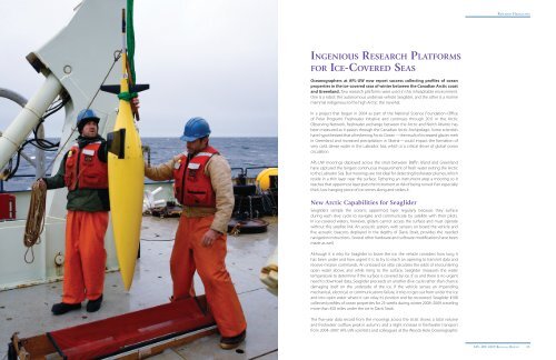
New Arctic Capabilities for Seaglider<br />
Seagliders sample the ocean’s uppermost layer regularly because they surface<br />
during each dive cycle to navigate and communicate by satellite with their pilots.<br />
In ice-covered waters, however, gliders cannot access the surface and must operate<br />
without this satellite link. An acoustic system, with sensors on board the vehicle and<br />
five acoustic beacons deployed in the depths of Davis Strait, provides the needed<br />
navigation instructions. Several other hardware and software modifications have been<br />
made as well.<br />
Although it is risky for Seaglider to brave the ice, the vehicle considers how long it<br />
has been under and how urgent it is to try to reach an opening to transmit data and<br />
receive mission commands. An onboard ice atlas calculates the odds of encountering<br />
open water above, and while rising to the surface, Seaglider measures the water<br />
temperature to determine if the surface is covered by ice. If so and there is no urgent<br />
need to download data, Seaglider proceeds on another dive cycle rather than chance<br />
damaging itself on the underside of the ice. If the vehicle senses an impending<br />
mechanical, electrical, or communications failure, it tries to get out from under the ice<br />
and into open water where it can relay its position and be recovered. Seaglider #108<br />
collected profiles of ocean properties for 25 weeks during winter 2008–<strong>2009</strong>, traveling<br />
more than 450 miles under the ice in Davis Strait.<br />
The five-year data record from the moorings across the strait shows a total volume<br />
and freshwater outflow peak in autumn, and a slight increase in freshwater transport<br />
from 2004–2007. APL-UW scientists and colleagues at the Woods Hole Oceanographic<br />
ReseARCh highLights<br />
22 APL–UW <strong>2009</strong> BienniAL RePoRt APL–UW <strong>2009</strong> BienniAL RePoRt 23