2009 Biennial (PDF, 12 MB) - Applied Physics Laboratory-University ...
2009 Biennial (PDF, 12 MB) - Applied Physics Laboratory-University ...
2009 Biennial (PDF, 12 MB) - Applied Physics Laboratory-University ...

You also want an ePaper? Increase the reach of your titles
YUMPU automatically turns print PDFs into web optimized ePapers that Google loves.
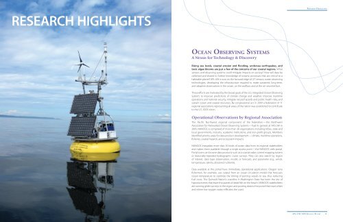
RESEARch hIGhLIGhTS<br />
ocean obServing SyStemS<br />
A Nexus for Technology & Discovery<br />
Rising sea levels, coastal erosion and flooding, undersea earthquakes, and<br />
toxic algae blooms are just a few of the concerns of our coastal regions. What<br />
sensors and observing systems could mitigate impacts on society? How will data be<br />
collected and shared to further knowledge of oceanic processes that are critical to a<br />
habitable planet? APL-UW is now on the forward edge of 21 st century ocean observing<br />
technologies, developing the infrastructure required to make sustained, long-term,<br />
and adaptive observations in the ocean, on the seafloor, and at the air–sea interface.<br />
These efforts are motivated by the broad goals of the U.S. Integrated Ocean Observing<br />
System: to improve predictions of climate change and weather, improve maritime<br />
operations and national security, mitigate natural hazards and public health risks, and<br />
sustain ocean and coastal resources. By congressional act in <strong>2009</strong> a federation of 11<br />
regional associations representing all areas of the nation was established to contribute<br />
to the U.S. IOOS vision.<br />
Operational Observations by Regional Association<br />
The Pacific Northwest regional component of the federation —the Northwest<br />
Association for Networked Ocean Observing Systems— had its genesis at APL-UW in<br />
2005. NANOOS is comprised of more than 30 organizations including tribes, state and<br />
local governments, industry, academic institutions, and non-profit groups. Members<br />
identified priority areas for data product development— climate, maritime operations,<br />
fisheries, coastal hazards, and ecosystem impacts.<br />
NANOOS integrates more than 50 kinds of ocean data from its regional stakeholders<br />
and makes them available through a single access point—the NANOOS web portal.<br />
Portal users can browse data products such as a coastal radar current mapping system<br />
or seasonally-repeated hydrographic cruise surveys. They can also search by region<br />
of interest, data type (observation, model, or forecast), and parameter (e.g., winds,<br />
temperature, salinity, dissolved nutrients).<br />
Data available at the portal have immediate, operational applications. Oregon tuna<br />
fishermen, for example, use output from an ocean circulation model that forecasts<br />
ocean temperature to optimize the timing of putting vessels to sea, thus reducing<br />
fuel costs. The Quinault Nation’s coastline in Washington State has been the site of<br />
hypoxia events that leave thousands of dead fish on the beach. NANOOS stakeholders<br />
are running glider surveys in the region and posting data to the portal that trace when<br />
and where low-oxygen water infiltrates the coast.<br />
ReseARCh highLights<br />
10 APL–UW <strong>2009</strong> BienniAL RePoRt APL–UW <strong>2009</strong> BienniAL RePoRt 11