Yukon River Unified Watershed Assessment - Yukon River Inter ...
Yukon River Unified Watershed Assessment - Yukon River Inter ...
Yukon River Unified Watershed Assessment - Yukon River Inter ...

Create successful ePaper yourself
Turn your PDF publications into a flip-book with our unique Google optimized e-Paper software.
<strong>Yukon</strong> <strong>River</strong> <strong>Unified</strong> <strong>Watershed</strong> <strong>Assessment</strong><br />
extent of the drainage provides a major repository for long-range transport of<br />
contaminants. Major long-range contaminants include heavy metals and herbicides and<br />
pesticides (Persistent Organic Pollutants). Persistent Organic Pollutants bio-accumulate in<br />
the food chain on which the Indigenous Peoples of the drainage rely on for sustenance.<br />
Climate Change is documented in the drainage. The average growing season has increased<br />
from 130 to 194 days and air temperatures are increasing at a rate of 1.4 O F (0.75 O C) per<br />
decade from 1961 – 1990 (USGS, 1999). This increase in temperature increase may be<br />
threatening the overall health of the watershed. Climate change and long-range transport<br />
of POP’s may not be controllable by the people who live in the drainage; many other sources<br />
of potential impacts are controllable.<br />
During the <strong>Watershed</strong> <strong>Assessment</strong> workshop held in Teslin, YT, the technical staff at the<br />
workshop spoke about the impacts and concerns to their communities and surrounding areas.<br />
Through this discussion, there were five areas, which were a constant theme from the<br />
headwaters to the mouth. These are 1) Military Impacts; 2) Mining Impacts; 3) Sewage<br />
Disposal; 4) Tourism; 5) Health of Subsistence Foods.<br />
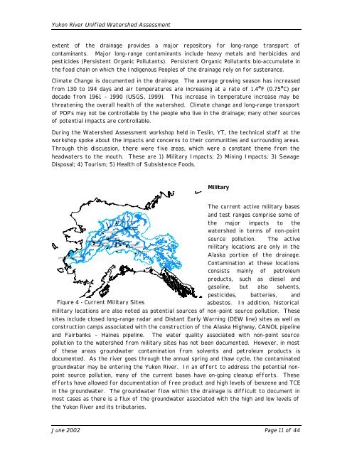
SAINT MARYS<br />
CAPE ROMANZOF<br />
BETTLES<br />
INDIAN MOUNTAIN<br />
CHANDALAR STATION<br />
SUMMIT<br />
FORT YUKON<br />
FORT YUKON<br />
CAMPIONGALENA<br />
TANANA AFS<br />
BEAR CREEK<br />
EIELSON<br />
GALENA AIRPORT CLEAR AFS<br />
FT. GREELEY<br />
KALAKAKET CREEK<br />
MINCHUMINA BIG DELTA/JUNCTION<br />
SLANA FACILITY<br />
Figure 4 - Current Military Sites<br />
Military<br />
The current active military bases<br />
and test ranges comprise some of<br />
the major impacts to the<br />
watershed in terms of non-point<br />
source pollution. The active<br />
military locations are only in the<br />
Alaska portion of the drainage.<br />
Contamination at these locations<br />
consists mainly of petroleum<br />
products, such as diesel and<br />
gasoline, but also solvents,<br />
pesticides, batteries, and<br />
asbestos. In addition, historical<br />
military locations are also noted as potential sources of non-point source pollution. These<br />
sites include closed long-range radar and Distant Early Warning (DEW line) sites as well as<br />
construction camps associated with the construction of the Alaska Highway, CANOL pipeline<br />
and Fairbanks – Haines pipeline. The water quality associated with non-point source<br />
pollution to the watershed from military sites has not been documented. However, in most<br />
of these areas groundwater contamination from solvents and petroleum products is<br />
documented. As the river goes through the annual spring and thaw cycle, the contaminated<br />
groundwater may be entering the <strong>Yukon</strong> <strong>River</strong>. In an effort to address the potential non-<br />
point source pollution, many of the current bases have on-going cleanup efforts. These<br />
efforts have allowed for documentation of free product and high levels of benzene and TCE<br />
in the groundwater. The groundwater flow within the drainage is difficult to document in<br />
most cases as there is a flux of the groundwater associated with the high and low levels of<br />
the <strong>Yukon</strong> <strong>River</strong> and its tributaries.<br />
June 2002 Page 11 of 44