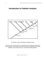
Using ecological niche modeling for quantitative biogeographic ...
Using ecological niche modeling for quantitative biogeographic ...
Using ecological niche modeling for quantitative biogeographic ...

You also want an ePaper? Increase the reach of your titles
YUMPU automatically turns print PDFs into web optimized ePapers that Google loves.
596 KAITLIN C. MAGUIRE AND ALYCIA L. STIGALL<br />
divided paleosols containing calcareous nodules<br />
from the Great Plains during the Miocene<br />
into three categories. The first category, mollic,<br />
contained all paleosols that adhered to the<br />
above criteria. The second category, nearmollic,<br />
was assigned to paleosols that had<br />
surface horizons with ‘‘a structure of subangular<br />
to rounded peds some 5–10 mm in size,<br />
along with abundant fine root traces and<br />
darker color than associated horizons’’ (Retallack<br />
1997). Near-mollic epipedons are found<br />
under bunch grasslands of woodlands or<br />
under desert grasslands (Retallack 1997). The<br />
third category, non-mollic, was assigned to all<br />
other paleosols included in the study. This<br />
third group consisted primarily of paleosols<br />
similar to soils of deserts and woodlands<br />
(Retallack 1997). We coded the vegetation<br />
cover interpreted from the three categories of<br />
mollic epipedons as 1, 2, and 3, respectively.<br />
Ecotope.—The fourth environmental variable<br />
included in this analysis is ecosystem<br />
type as determined from paleobotanical studies<br />
(Table 2). Although an extensive collection<br />
of paleobotanical occurrences and taxonomic<br />
descriptions exists in the literature, only<br />
studies that included a paleoenvironmental<br />
description were included in the data set <strong>for</strong><br />
this analysis. These environmental descriptions<br />
were coded and divided into four<br />
categories:<br />
1. Woodland (e.g., ‘‘deciduous valley and<br />
riparian <strong>for</strong>ests with scattered grasslands’’<br />
[Axelrod 1985])<br />
2. Savanna or subtropical grassland with<br />
surrounding wooded areas (e.g., ‘‘subtropical<br />
grassland with associated mesic<br />
and woody components’’ [Thomasson<br />
2005])<br />
3. Savanna or subtropical grassland (e.g.,<br />
‘‘grassland savanna’’ [Gabel et al. 1998])<br />
4. Dominantly grassland/Steppe (e.g.,<br />
‘‘grassland, shrubs, with limited trees’’<br />
[Thomasson 1990])<br />
Crocodilian Distribution.—In the fossil record,<br />
crocodilian occurrence has traditionally<br />
been used as a paleotemperature proxy (Lyell<br />
1830; Owen 1850). Ecological analysis of<br />
modern crocodilians indicates that temperature<br />
is the most influential factor determining<br />
their distribution (Woodburne 1959; Martin<br />
1984; Markwick 1996). The data set used in this<br />
analysis is derived from the comprehensive<br />
work of Markwick (1996, 2007). Markwick<br />
(1996) compiled a global database of vertebrate<br />
assemblages and used the distribution of<br />
crocodilians as a paleotemperature proxy from<br />
the Cretaceous through the Neogene. Markwick<br />
(1996) includes crocodilians that belong to<br />
the ‘‘crown group’’ (Alligatoridae, Crocodylidae,<br />
and Gavialidae families). The climatic<br />
tolerance of the modern American alligator,<br />
Alligator mississippiensis, was used as the<br />
minimum temperature tolerance of extinct<br />
crocodilians. Alligator mississippiensis can tolerate<br />
a mean temperature range of 25–35uC.<br />
Because crocodilians are well documented in<br />
the fossil record and Markwick (1996, 2007)<br />
includes vertebrate sites lacking crocodilians as<br />
a control group, crocodilian absences in his<br />
database are considered true absences. This<br />
study includes 95 assemblages from Markwick<br />
(2007) that fall within the study area. For this<br />
study, crocodilian presence and absences were<br />
coded 1 and 0, respectively.<br />
Creation of Environmental Layers<br />
For analysis of environmental data, the<br />
study region was divided into 1u grid boxes<br />
using latitude and longitude coordinates, as<br />
discussed above, and environmental parameters<br />
derived from the literature were assigned<br />
to the appropriate grid box. When<br />
multiple data points occurred in one grid box,<br />
the values were averaged to account <strong>for</strong><br />
environmental variability. This method of<br />
intermediate coding has been successful with<br />
ENM analysis and is an effective method of<br />
representing environmental variability (Stigall<br />
Rode and Lieberman 2005). Raw data are<br />
included in the supplementary material.<br />
Environmental data points <strong>for</strong> both time<br />
slices were imported into ArcGIS 9.2 (ESRI<br />
Inc. 2006). For each environmental variable<br />
we used four data points to create an<br />
interpolated surface using inverse distance<br />
weighting, a method that allows us to use a<br />
set of scattered points to assign values to<br />
unknown points. Each interpolated surface<br />
had a power of 3 (exponent of distance) and