Sistemes naturals - Ajuntament de Gavà
Sistemes naturals - Ajuntament de Gavà
Sistemes naturals - Ajuntament de Gavà

Create successful ePaper yourself
Turn your PDF publications into a flip-book with our unique Google optimized e-Paper software.
Auditoria Ambiental <strong>de</strong> <strong>Gavà</strong> Memòria <strong>de</strong>scriptiva<br />
4.4. Gestió <strong>de</strong>ls sistemes agrícola, forestal i hidrològic.<br />
4.4.1. Sistema agrari<br />
4.4.1.1. Enfocament territorial<br />
Per a la caracterització <strong>de</strong>l sistema agrícola <strong>de</strong>l municipi s’han tingut en consi<strong>de</strong>ració<br />
les da<strong>de</strong>s <strong>de</strong>l Cens Agrícola realitzat al 1999.<br />
Cal remarcar que les da<strong>de</strong>s que es mostren <strong>de</strong>l Censos Agraris provenen <strong>de</strong> les<br />
<strong>de</strong>claracions <strong>de</strong>ls propietaris. Aquest fet dóna algunes vega<strong>de</strong>s com a resultat una<br />
superfície agrícola menor <strong>de</strong> la que realment existeix, a causa <strong>de</strong> la no <strong>de</strong>claració per<br />
part d’alguns propietaris.<br />
Al municipi <strong>de</strong> <strong>Gavà</strong>, la superfície agrària total és <strong>de</strong> 697 ha. Aquesta superfície ha<br />
incrementat un 12% en els darrers 17 anys, passant <strong>de</strong> 608 ha l’any 1982 a 697 ha<br />
l’any 1999. Aquest increment però, no ha estat gràcies a l’augment <strong>de</strong> la superfície<br />
agrícola utilitzada sinó al terreny forestal (zones naturalitza<strong>de</strong>s i <strong>de</strong> ribera). Per contra<br />
la superfície <strong>de</strong> terra llaurada s’ha reduït quasi a la meitat i el terreny <strong>de</strong> pastura<br />
permanent continua essent inexistent.<br />
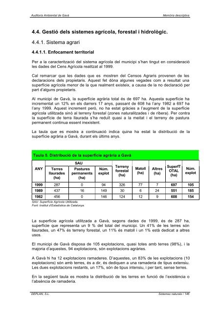
La taula que es mostra a continuació indica quina ha estat la distribució <strong>de</strong> la<br />
superfície agrària a <strong>Gavà</strong>, durant els últims anys.<br />
Taula 5. Distribució <strong>de</strong> la superfície agrària a <strong>Gavà</strong><br />
ANY Terres<br />
llaura<strong>de</strong>s<br />
(ha)<br />
SAU<br />
Pastures<br />
permanents<br />
(ha)<br />
Núm.<br />
explot<br />
Terreny<br />
forestal<br />
(ha)<br />
Matoll<br />
(ha)<br />
Altres<br />
(ha)<br />
SuperfT<br />
OTAL<br />
(ha)<br />
DEPLAN, S.L. <strong>Sistemes</strong> <strong>naturals</strong> / 146<br />
Núm.<br />
explot<br />
1999 287 0 94 326 77 7 697 105<br />
1989 437 16 149 30 6 24 551 185<br />
1982 456 0 146 124 12 9 608 154<br />
SAU: Superfície Agrícola Utilitzada.<br />
Font: Institut d’Estadística <strong>de</strong> Catalunya.<br />
La superfície agrícola utilitzada a <strong>Gavà</strong>, segons da<strong>de</strong>s <strong>de</strong> 1999, és <strong>de</strong> 287 ha,<br />
superfície que representa un 9 % <strong>de</strong>l total <strong>de</strong>l municipi. Un 41% <strong>de</strong> les terres són<br />
llaura<strong>de</strong>s, un 47% és terreny forestal, un 11% és matoll i un 1% està <strong>de</strong>dicat a altres<br />
usos.<br />
El municipi <strong>de</strong> <strong>Gavà</strong> disposa <strong>de</strong> 105 explotacions, quasi totes amb terres (98%), i la<br />
majoria d’aquestes, 94 explotacions, són explotacions agràries.<br />
A <strong>Gavà</strong> hi ha 12 explotacions rama<strong>de</strong>res. D’aquestes, un 83% <strong>de</strong> les explotacions (10<br />
explotacions) són amb terres, és a dir, és <strong>de</strong>diquen a una rama<strong>de</strong>ria <strong>de</strong> tipus extensiu.<br />
Les dues explotacions restants, un 17%, són <strong>de</strong> tipus intensiu, i per tant, sense terres.<br />
En la següent taula es mostra la distribució <strong>de</strong> les terres en funció <strong>de</strong> l’existència o<br />
l’absència <strong>de</strong> rama<strong>de</strong>ria.