
You also want an ePaper? Increase the reach of your titles
YUMPU automatically turns print PDFs into web optimized ePapers that Google loves.
de la Costa da Morte.<br />
Longitud aproximada: 12 km.<br />
Duración aproximada: 4 horas.<br />
Dificultad: baja.<br />
Lugares de mayor interés: museo<br />
del Alemán, peñas y costa<br />
de Camelle a Mordomo, playa,<br />
laguna e iglesia de Traba, playa<br />
de Soesto y villa de Laxe.<br />
Cee-San Pedro Mártir<br />
Ruta por diversas parroquias<br />
del municipio de Cee. Incluye<br />
varios elementos de arte religioso,<br />
un conjunto de antiguos<br />
molinos restaurados y un tramo<br />
de la ruta jacobea.<br />
Longitud aproximada: 12km.<br />
Duración aproximada: 4 horas<br />
Dificultad: media-baja. La dificultad<br />
estaría en la subida a lo<br />
<strong>al</strong>to de San Pedro Mártir.<br />
Lugares de mayor interés: Cee,<br />
área recreativa de los molinos<br />
de Toba, Iglesia de Toba y San<br />
Pedro Mártir.<br />
Rutas sobre ruedas<br />
Carb<strong>al</strong>lo-Caión<br />
Recorrido desde la capit<strong>al</strong> de<br />
Bergantiños hasta la villa marinera<br />
de Caión, con hermosas<br />
vistas de los extensos aren<strong>al</strong>es<br />
de la costa carb<strong>al</strong>lesa y numerosas<br />
muestras de arte religioso.<br />
Longitud aproximada: 20 km.<br />
Duración aproximada: 2 horas y<br />
media.<br />
Dificultad: media-baja. Las dificultades<br />
se sitúan en la subida<br />
de Arnados <strong>al</strong> Castrillón y la<br />
subida de Constenla. Puede<br />
presentar también cierta dificultad<br />
<strong>al</strong>guna parte de la carretera<br />
que carece de arcén.<br />
Lugares de mayor interés: playa<br />
de Razo, laguna y marisma de<br />
B<strong>al</strong>daio, panorámicas sobre el<br />
mar y la villa de Caión.<br />
Ruta de los dólmenes<br />
Recorrido por los monumentos<br />
meg<strong>al</strong>íticos más representativos<br />
de la Costa da Morte.<br />
Longitud aproximada: 28 kkm<br />
Duración aproximada: 3 horas y<br />
media.<br />
Dificultad: baja.<br />
Lugares de mayor interés: dólmen<br />
de Dombate, Pedra Cuberta,<br />
Arca da Piosa y Pedra da Arca.<br />
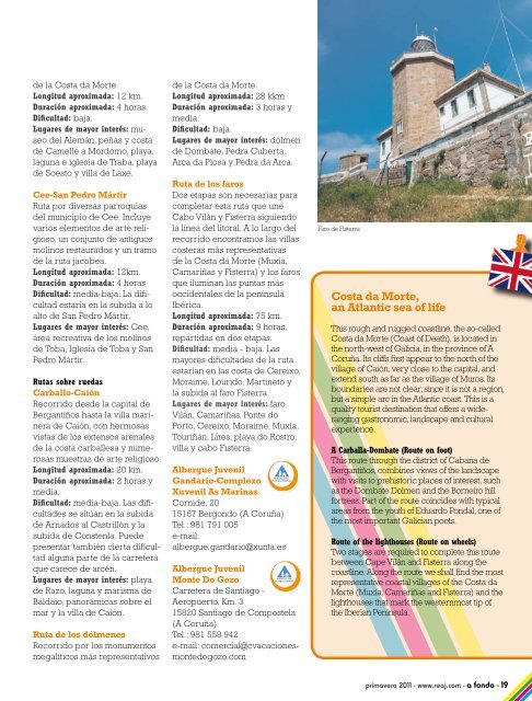
Ruta de los faros<br />
Dos etapas son necesarias para<br />
completar esta ruta que une<br />
Cabo Vilán y Fisterra siguiendo<br />
la línea del litor<strong>al</strong>. A lo largo del<br />
recorrido encontramos las villas<br />
costeras más representativas<br />
de la Costa da Morte (Muxía,<br />
Camariñas y Fisterra) y los faros<br />
que iluminan las puntas más<br />
occident<strong>al</strong>es de la península<br />
Ibérica.<br />
Longitud aproximada: 75 km.<br />
Duración aproximada: 9 horas,<br />
repartidas en dos etapas.<br />
Dificultad: media - baja. Las<br />
mayores dificultades de la ruta<br />
estarían en las costa de Cereixo,<br />
Moraime, Lourido, Martineto y<br />
la subida <strong>al</strong> faro Fisterra.<br />
Lugares de mayor interés: faro<br />
Vilán, Camariñas, Ponte do<br />
Porto, Cereixo, Moraime, Muxía,<br />
Touriñán, Lires, playa do Rostro,<br />
villa y cabo Fisterra.<br />
Albergue Juvenil<br />
Gandario-Complexo<br />
Xuvenil As Marinas<br />
Cornide, 20<br />
15167 Bergondo (A Coruña)<br />
Tel.: 981 791 005<br />
e-mail:<br />
<strong>al</strong>bergue.gandario@xunta.es<br />
Albergue Juvenil<br />
Monte Do Gozo<br />
Carretera de Santiago -<br />
Aeropuerto, Km. 3<br />
15820 Santiago de Compostela<br />
(A Coruña)<br />
Tel.: 981 558 942<br />
e-mail: comerci<strong>al</strong>@cvacacionesmontedogozo.com<br />
Faro de Fisterra<br />
Costa da Morte,<br />
an Atlantic sea of life<br />
This rough and rugged coastline, the so-c<strong>al</strong>led<br />
Costa da Morte (Coast of Death), is located in<br />
the north-west of G<strong>al</strong>icia, in the province of A<br />
Coruña. Its cliffs first appear to the north of the<br />
village of Caión, very close to the capit<strong>al</strong>, and<br />
extend south as far as the village of Muros. Its<br />
boundaries are not clear, since it is not a region,<br />
but a simple arc in the Atlantic coast. This is a<br />
qu<strong>al</strong>ity tourist destination that offers a wideranging<br />
gastronomic, landscape and cultur<strong>al</strong><br />
experience.<br />
A Carb<strong>al</strong>la-Dombate (Route on foot)<br />
This route through the district of Cabana de<br />
Bergantiños, combines views of the landscape<br />
with visits to prehistoric places of interest, such<br />
as the Dombate Dolmen and the Borneiro hill<br />
fortress. Part of the route coincides with typic<strong>al</strong><br />
areas from the youth of Eduardo Pond<strong>al</strong>, one of<br />
the most important G<strong>al</strong>ician poets.<br />
Route of the lighthouses (Route on wheels)<br />
Two stages are required to complete this route<br />
between Cape Vilán and Fisterra <strong>al</strong>ong the<br />
coastline. Along the route we sh<strong>al</strong>l find the most<br />
representative coast<strong>al</strong> villages of the Costa da<br />
Morte (Muxía, Camariñas and Fisterra) and the<br />
lighthouses that mark the westernmost tip of<br />
the Iberian Peninsula.<br />
<strong>primavera</strong> 2011 - www.reaj.com - a fondo - 1