Cuba: Camagüey, Sierra de Cubitas - The Field Museum
Cuba: Camagüey, Sierra de Cubitas - The Field Museum
Cuba: Camagüey, Sierra de Cubitas - The Field Museum

Create successful ePaper yourself
Turn your PDF publications into a flip-book with our unique Google optimized e-Paper software.
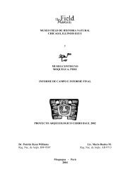
JI<br />
<br />
La Habana<br />
CUBA<br />
<strong>Camagüey</strong><br />
EP<br />
Kilómetros/Kilometers<br />
CUBA: <strong>Sierra</strong><br />
<strong>de</strong> <strong>Cubitas</strong><br />
Localida<strong>de</strong>s/Localities<br />
Santiago<br />
BG = Bahía <strong>de</strong> la Gloria<br />
CU = <strong>Cubitas</strong><br />
EM= Embalse Máximo<br />
EP = Embalse Pontezuela<br />
JI = Jiquí<br />
PL = Paso <strong>de</strong> Lesca<br />
SO = Sola<br />
VT = Vilató<br />
5 10<br />
FIG.2A El bosque <strong>de</strong> la <strong>Sierra</strong><br />
<strong>de</strong> <strong>Cubitas</strong> aparece en anaranjado<br />
en la parte central <strong>de</strong> esta<br />
imagen <strong>de</strong> satélite <strong>de</strong> color falso.<br />
Adyacente, al sur, una llanura<br />
gran<strong>de</strong> con suelos serpentinosos<br />
aparece en ver<strong>de</strong>. Proponemos<br />
que el área manejada para<br />
la conservación se incremente<br />
<strong>de</strong> manera substancial, <strong>de</strong><br />
forma tal que conecte dos<br />
pequeñas reservas propuestas<br />
anteriormente, que ahora<br />
están siendo consi<strong>de</strong>radas con<br />
vistas a su protección./<strong>The</strong> forest<br />
cover of the <strong>Sierra</strong> <strong>de</strong> <strong>Cubitas</strong><br />
appears in orange across the<br />
center of this false-color satellite<br />
image. Adjacent, to the south, a<br />
large plain with serpentine soils<br />
appears in green. We propose that<br />
the area managed for conservation<br />
be increased substantially in a<br />
PL<br />
VT<br />
<strong>Camagüey</strong> (14 km) ➞<br />
CU<br />
way that connects two small,<br />
proposed reserves now un<strong>de</strong>r<br />
consi<strong>de</strong>ration for protection.<br />
Pequeñas reservas<br />
propuestas anteriormente/<br />
Small reserves proposed<br />
earlier:<br />
Área Protegida <strong>de</strong> Recursos<br />
Manejados Escarpa y<br />
Humedales <strong>de</strong> San Felipe<br />
(al oeste/to the west)<br />
Reserva Ecológica<br />
Limones-Tuabaquey<br />
(al este/to the east)<br />
Límite <strong>de</strong> la expansión<br />
propuesta <strong>de</strong>l área que<br />
será manejada para la<br />
conservación. Las áreas<br />
pobladas han sido<br />
excluidas./Boundary<br />
of proposed expansion<br />
EM<br />
BG<br />
SO<br />
of area to be managed for<br />
conservation. Populated<br />
areas have been exclu<strong>de</strong>d.<br />
Límite <strong>de</strong>l área <strong>de</strong> la<br />
periferia que necesita<br />
inventarios <strong>de</strong> campo (no<br />
visitada por nuestro equipo<br />
<strong>de</strong> inventario rápido)./<br />
Boundary of perpheral areas<br />
in need of field inventory<br />
(not visited by our rapid<br />
inventory team).<br />
FIG.2B Farallones <strong>de</strong> roca<br />
caliza y terrenos cársicos <strong>de</strong> la<br />
<strong>Sierra</strong>./Limestone cliffs and karst<br />
terrain of the <strong>Sierra</strong>.<br />
FIG.2C Sabana <strong>de</strong> palmeras sobre<br />
la llanura ofiolítica al sur <strong>de</strong> la<br />
<strong>Sierra</strong>./Palm savanna on the<br />
ophiolitic plain south of the <strong>Sierra</strong>.<br />
2A