Manual de diseño y construcción de Pequeñas presas (DINAGUA)
Manual de diseño y construcción de Pequeñas presas (DINAGUA)
Manual de diseño y construcción de Pequeñas presas (DINAGUA)

Create successful ePaper yourself
Turn your PDF publications into a flip-book with our unique Google optimized e-Paper software.
00 01 02 03 i a b C d e i bl<br />
0 :<br />
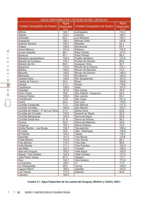
AguA disponiBle <strong>de</strong> los suelos <strong>de</strong>l uruguAy<br />
agua<br />
agua<br />
Unidad Cartográfica <strong>de</strong> Suelos disponible Unidad Cartográfica <strong>de</strong> Suelos disponible<br />
(mm)<br />
(mm)<br />
Alférez 124,7 Lechiguana 113,3<br />
Algorta 123,7 Libertad 146,7<br />
Andresito 63,7 Los Mimbres 100,1<br />
Angostura 155,1 Manuel Oribe 145,8<br />
Aparicio Saravia 139,7 Masoller 52,1<br />
Arapey 136,8 Montecoral 84,7<br />
Arroyo Blanco 101,0 Palleros 116,5<br />
Arroyo Hospital 86,1 Paso Cohelo 147,4<br />
Bacacuá 97,1 Paso Palmar 88,2<br />
Balneario Jaureguiberry 134,5 Pueblo <strong>de</strong>l Barro 131,6<br />
Bañado <strong>de</strong> Farrapos 178,7 Puntas <strong>de</strong> Herrera 85,8<br />
Bañado <strong>de</strong> Oro 89,0 Queguay Chico 32,7<br />
Baygorria 110,5 Rincón <strong>de</strong> la Urbana 131,1<br />
Bellaco 146,2 Rincón <strong>de</strong> Ramirez 73,3<br />
Bequeló 138,2 Rincón <strong>de</strong> Zamora 148,3<br />
Blanquillo 114,6 Río Branco 102,0<br />
Cañada Nieto 146,4 Río Tacuarembó 161,0<br />
Capilla <strong>de</strong> Farruco 35,4 Risso 150,6<br />
Carapé 41,5 Rivera 179,6<br />
Carpintería 139,0 Salto 107,2<br />
Cebollatí 167,6 San Carlos 78,0<br />
Cerro Chato 78,6 San Gabriel - Guaycurú 92,4<br />
Colonia Palma 108,9 San Jacinto 83,1<br />
Constitución 73,6 San Jorge 141,2<br />
Cuaró 93,2 San Luis 176,2<br />
Cuchilla Caraguatá 71,2 San Manuel 117,3<br />
Cuchilla Corrales 160,6 San Ramón 152,7<br />
Cuchilla <strong>de</strong> Haedo – P. <strong>de</strong> Los Toros 21,5 Santa Clara 63,6<br />
Cuchilla <strong>de</strong>l Corralito 119,8 Sarandí <strong>de</strong> Tejera 50,0<br />
Cuchilla Mangueras 150,2 Sierra <strong>de</strong> Aiguá 42,6<br />
Cuchilla Santa Ana 51,8 Sierra <strong>de</strong> Ánimas 50,1<br />
Curtina 55,2 Sierra <strong>de</strong> Mahoma 43,9<br />
Chapicuy 100,1 Sierra Polanco 73,0<br />
Ecilda Paullier - Las Brujas 136,7 Tacuarembó 168,4<br />
El Ceibo 78,6 Tala - Rodríguez 130,9<br />
El Palmito 142,3 Toledo 118,7<br />
Espinillar 141,0 Tres Bocas 110,8<br />
Fraile Muerto 133,4 Tres Cerros 85,1<br />
Fray Bentos 115,4 Tres Islas 96,6<br />
India Muerta 171,1 Tres Puentes 103,4<br />
Isla Mala 102,1 Trinidad 148,4<br />
Islas <strong>de</strong>l Uruguay 183,0 Valle Aiguá 102,8<br />
Itapebí -Tres Arboles 124,2 Valle Fuentes 131,4<br />
José Pedro Varela 87,2 Vergara 117,1<br />
Kiyú 154,7 Villa Soriano 173,3<br />
La Carolina 156,1 Yí 71,0<br />
La Charqueada 95,2 Young 145,0<br />
Laguna Merín 169,3 Zapallar 153,2<br />
Las Toscas 177,5 Zapicán 84,8<br />
Lascano 126,4<br />
Cuadro 2.1. Agua Disponible <strong>de</strong> los suelos <strong>de</strong>l Uruguay (Molfino y Califra, 2001)<br />
22 disEño y <strong>construcción</strong> dE pEquEñas prEsas