plan de desarrollo urbano de puno - actualizacion - Municipalidad ...
plan de desarrollo urbano de puno - actualizacion - Municipalidad ...
plan de desarrollo urbano de puno - actualizacion - Municipalidad ...

You also want an ePaper? Increase the reach of your titles
YUMPU automatically turns print PDFs into web optimized ePapers that Google loves.
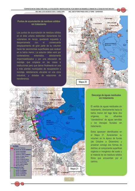
“CONTRATACIÓN DE CONSULTORÍA PARA LA ACTUALIZACIÓN Y MODIFICACIÓN DEL PLAN VIGENTE DE DESARROLLO URBANO DE LA CIUDAD DE PUNO 2008-2012”<br />
ARQ. NINA LUCÍA ASCENCIO COSTA – CONSULTORA<br />
ARQ. JOSÉ VITTORIO PINEDA ARCE LA TORRE – SUPERVISOR<br />
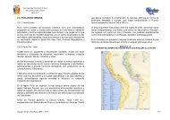
Puntos <strong>de</strong> acumulación <strong>de</strong> residuos sólidos<br />
sin tratamiento<br />
Los puntos <strong>de</strong> acumulación <strong>de</strong> residuos sólidos<br />
en el área urbana <strong>de</strong>sbordan diariamente los<br />
volúmenes <strong>de</strong> recojo, quedando expuesta y<br />
<strong>de</strong>sparramada con el consecuente<br />
<strong>de</strong>splazamiento <strong>de</strong> gran parte <strong>de</strong> su volumen<br />
hacia las escorrentías superficiales que acaban<br />
en la bahía menor. La solución <strong>de</strong>be venir por<br />
contenedores enterrados, <strong>de</strong>bidamente<br />
impermeabilizados y por una educación <strong>de</strong><br />
reciclaje que empiece en las casas e<br />
instituciones pero que <strong>de</strong>rive finalmente en una<br />
o más <strong>plan</strong>tas municipales <strong>de</strong> recuperación y<br />
reciclaje, <strong>de</strong>bidamente ubicadas en una zona<br />
industrial, y dotadas <strong>de</strong> estaciones <strong>de</strong><br />
transferencia.<br />
Mapa 20<br />
Descarga <strong>de</strong> águas residuales<br />
sin tratamiento<br />
El vertido <strong>de</strong> aguas residuales sin<br />
tratamiento, directamente hacia la<br />
bahía menor <strong>de</strong>l lago tiene dos<br />
orígenes, los efluentes<br />
“clan<strong>de</strong>stinos” <strong>de</strong> aguas servidas<br />
y los drenajes fluviales sin<br />
tratamiento.<br />
Estos aparecen i<strong>de</strong>ntificados en<br />
el Mapa 21. Acrecientan su<br />
volumen en la época <strong>de</strong> lluvias<br />
(<strong>de</strong> Octubre a Diciembre) y<br />
arrastran consigo dos formas <strong>de</strong><br />
<strong>de</strong>tritos: el componente superficial<br />
orgánico e inorgánico <strong>de</strong>l suelo y<br />
el material <strong>de</strong> los residuos sólidos<br />
libres que encuentran por el<br />
camino.<br />
Mapa 21<br />
- 19 -