Caracterización geornorfológica del talud y la plataforma ...
Caracterización geornorfológica del talud y la plataforma ...
Caracterización geornorfológica del talud y la plataforma ...

You also want an ePaper? Increase the reach of your titles
YUMPU automatically turns print PDFs into web optimized ePapers that Google loves.
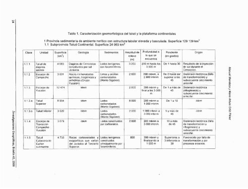
Tab<strong>la</strong> 1. <strong>Caracterización</strong> geomorfologica <strong>del</strong> <strong>talud</strong> y <strong>la</strong> p<strong>la</strong>taforma continentales<br />
1 Provincia sedímentaria de ambiente nerítico con estructura tabu<strong>la</strong>r elevada y bascu<strong>la</strong>da. Superficie 129 1<br />
1.1 Subprovincia Talud Continental. Superficie 24 969 kmz<br />
Pendiente<br />
(en grados)<br />
Profundidad a<br />
<strong>la</strong> que Se<br />
encuentra<br />
C<strong>la</strong>ve<br />
De 1 hasta 30<br />
Amplitud de<br />
relieve<br />
(m)<br />
3 200<br />
Sedimentos<br />
Geologia<br />
Supeficie<br />
(km2)<br />
Unidad<br />
Resu<br />
de sa<br />
Ceno<br />
200 m hasta los<br />
3 500 m<br />
Lodos terrigenos<br />
con foraminiferos.<br />
Diapiros de Cenozoiw<br />
constituidos por sal<br />
Jurásica.<br />
4 683<br />
1.1.1<br />
Diste<br />
de tra<br />
subse<br />
arrec<br />
De 2 hasta ser<br />
superior a los<br />
45<br />
200 mbnm. a<br />
2 800 mbnm<br />
2 600<br />
Limos y arcil<strong>la</strong>s<br />
carbonatados<br />
(Manto Sigsbee).<br />
Taludde<br />
diapiros<br />
salinos<br />
Escarpe de<br />
Campeche<br />
Rocas carbonatadas<br />
químicas. biogénicas y<br />
anhidritas (Grupo<br />
Y ucata n).<br />
ldem<br />
3 031<br />
1.1.2<br />
Diste<br />
(rifiog<br />
subse<br />
arrec<br />
De 1 a mas de<br />
45<br />
200 mbnm y<br />
final a los 3 000<br />
m<br />
2 800<br />
12 474<br />
Escarpe de<br />
Yucatán<br />
1.1.3<br />
De 1 a 10<br />
200 mbnm a<br />
1 O00 rnbnm<br />
8 O00<br />
Lodos<br />
carbonatados<br />
(Manto Sigsbee).<br />
ldem<br />
8 954<br />
Talud<br />
Superior<br />
1 1 3.a<br />
5 y mas de<br />
45<br />
1 000 mbnm a<br />
3 000 mbnm<br />
2 000<br />
Lodos<br />
carbonatados<br />
ldem<br />
3 520<br />
Talud Inferior<br />
1.1.3.b<br />
(Manto Sigsbee)<br />
Diste<br />
de tra<br />
riftog<br />
subse<br />
arrec<br />
Favo<br />
trans<br />
proce<br />
10 a más<br />
de 45<br />
200 mbnm a<br />
3 000 mbnm<br />
Lodos constituidos 1 2 800<br />
por carbonatos.<br />
ldem<br />
3 079<br />
Escarpe de<br />
Transición<br />
Campeche-<br />
Yucatan<br />
1.1.4<br />
Superiores a<br />
3 inferiores a<br />
30<br />
200 mbnm y<br />
finalizando a<br />
1 000 m<br />
800<br />
Lodos terrigenos<br />
constituidos<br />
principalmente por<br />
foraminiferos.<br />
Rocas carbonatadas y<br />
evaporiticas que varjan<br />
<strong>del</strong> Jurásico al Terciario<br />
Superior.<br />
4 733<br />
Talud<br />
Cabecera de<br />
Caíión<br />
submarino<br />
1.1.5