
You also want an ePaper? Increase the reach of your titles
YUMPU automatically turns print PDFs into web optimized ePapers that Google loves.
Acequia<br />
<strong>de</strong>l Rey<br />
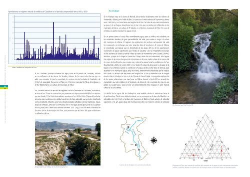
Aportaciones en régimen natural al embalse <strong>de</strong> Guadalest en el período comprendido entre 1967 y 2010<br />
160<br />
140<br />
120<br />
100<br />
Río Vinalopó<br />
El río Vinalopó nace en <strong>la</strong> sierra <strong>de</strong> Mario<strong>la</strong>, discurriendo inicialmente entre los relieves <strong>de</strong><br />
Fontanel<strong>la</strong> y So<strong>la</strong>na, por el valle <strong>de</strong> Biar. Su cuenca es <strong>la</strong> más extensa <strong>de</strong> <strong>la</strong> <strong>provincia</strong>, abarca<br />
unos 1.692 km 2 y su cauce tiene una longitud <strong>de</strong> 81 km. Se trata <strong>de</strong> una cuenca endorreica,<br />
ya que el río no llega a <strong>de</strong>sembocar en el mar, sino que se pier<strong>de</strong> por infiltración en los<br />
materiales <strong>de</strong>tríticos, a <strong>la</strong> altura <strong>de</strong> El Sa<strong>la</strong>dar, en el término municipal <strong>de</strong> Elche. En caso <strong>de</strong><br />
crecidas, un azarbe conduce <strong>la</strong>s aguas al mar.<br />
Los recursos hídricos superficiales y su regu<strong>la</strong>ción At<strong>la</strong>s <strong>hidrogeológico</strong> <strong>de</strong> <strong>la</strong> <strong>provincia</strong> <strong>de</strong> <strong>Alicante</strong><br />
06<br />
44<br />
hm 3 /año<br />
80<br />
60<br />
40<br />
20<br />
0<br />
Abr 67<br />
Oct 68<br />
Abr 69<br />
Oct 70<br />
Abr 71<br />
Oct 72<br />
Abr 73<br />
Oct 74<br />
Abr 75<br />
Oct 76<br />
Abr 77<br />
Oct 78<br />
Abr 79<br />
Oct 80<br />
Abr 81<br />
Oct 82<br />
Abr 83<br />
Oct 84<br />
Abr 85<br />
Oct 86<br />
Abr 87<br />
Oct 88<br />
Abr 89<br />
Oct 90<br />
Abr 91<br />
Oct 92<br />
Abr 93<br />
Oct 94<br />
Abr 95<br />
Oct 96<br />
Abr 97<br />
Oct 98<br />
Abr 99<br />
Oct 00<br />
Abr 01<br />
Oct 02<br />
Abr 03<br />
Oct 04<br />
Abr 05<br />
Oct 06<br />
Abr 07<br />
Oct 08<br />
Abr 09<br />
Fuente: Confe<strong>de</strong>ración Hidrográfica <strong>de</strong>l Júcar<br />
El río Guadalest, principal afluente <strong>de</strong>l Algar, nace en el puerto <strong>de</strong> Confri<strong>de</strong>s, situado<br />
en <strong>la</strong> confluencia <strong>de</strong> <strong>la</strong>s sierras <strong>de</strong> Serrel<strong>la</strong> y Aitana. En <strong>la</strong> cuenca alta discurre por un<br />
valle muy encajado, lo que ha propiciado <strong>la</strong> construcción <strong>de</strong>l embalse <strong>de</strong> Guadalest, <strong>de</strong><br />
13 hm 3 <strong>de</strong> capacidad. Tras unirse al Algar, en el término municipal <strong>de</strong> Altea, <strong>de</strong>semboca en<br />
el Mar Mediterráneo a <strong>la</strong> altura <strong>de</strong>l municipio <strong>de</strong> Altea.<br />
Los caudales medios <strong>de</strong> entrada en régimen natural al embalse <strong>de</strong> Guadalest, se estiman,<br />
en unos 8 hm 3 . Estos se caracterizan por presentar una importante variabilidad con aportes<br />
que van <strong>de</strong>s<strong>de</strong> 0,1 hm 3 /año hasta valores superiores a los 100 hm 3 /año. El agua <strong>de</strong>l embalse<br />
presenta unas condiciones <strong>de</strong> calidad excelentes, <strong>de</strong> baja salinidad, que permiten c<strong>la</strong>sificar<strong>la</strong><br />
como prepotable. Muestra unas facies bicarbonatadas-sulfatadas cálcica-magnésica. Aguas<br />
abajo <strong>de</strong>l embalse, antes <strong>de</strong> <strong>la</strong> confluencia con el río Algar, pier<strong>de</strong> gran parte <strong>de</strong> su aptitud<br />
<strong>de</strong> uso, pues pasa a tener una salinidad <strong>de</strong> entre 1,6 a 1,8 g/L. Esto se <strong>de</strong>be al lixiviado <strong>de</strong><br />
los yesos <strong>de</strong> <strong>la</strong>s facies Keuper <strong>de</strong>l Trías, que provocan que <strong>la</strong>s facies <strong>de</strong>l agua evolucionen<br />
a sulfatadas cálcicas.<br />
En un primer tramo el cauce lleva normalmente agua, pero se infiltra, más a<strong>de</strong><strong>la</strong>nte, en<br />
los materiales aluviales <strong>de</strong> gran permeabilidad <strong>de</strong>l valle, para volver a surgir a <strong>la</strong> altura<br />
<strong>de</strong>l municipio <strong>de</strong> Villena. El régimen <strong>de</strong> explotación <strong>de</strong>l acuífero carbonatado <strong>de</strong>l valle<br />
ha ocasionado, sin embargo, que esta situación <strong>de</strong>je <strong>de</strong> producirse. Al oeste <strong>de</strong> Villena,<br />
se encontraba una <strong>la</strong>guna que se alimentaba <strong>de</strong> <strong>la</strong>s aguas <strong>de</strong>l río, <strong>de</strong> <strong>la</strong>s aportaciones<br />
ocasionales <strong>de</strong> aguas superficiales que recibía <strong>de</strong> Cau<strong>de</strong>te, y <strong>de</strong> <strong>la</strong>s importantes <strong>de</strong>scargas<br />
<strong>de</strong> los acuíferos <strong>de</strong> So<strong>la</strong>na y Jumil<strong>la</strong>-Villena (a través <strong>de</strong> manantiales como Cuartel, Chorros,<br />
Bordoño, y Hoyo <strong>de</strong> <strong>la</strong> Virgen o Fuente <strong>de</strong>l Chopo, entre los más relevantes). Esta <strong>la</strong>guna<br />
fue origen <strong>de</strong> <strong>la</strong>s tomas <strong>de</strong> agua más importantes en <strong>la</strong> parte media y baja <strong>de</strong> <strong>la</strong> cuenca <strong>de</strong>l<br />
río, pues <strong>de</strong>s<strong>de</strong> allí partía una acequia que conducía <strong>la</strong>s aguas hacia <strong>la</strong>s pob<strong>la</strong>ciones <strong>de</strong> Sax,<br />
Novelda, Elda y Elche. En el año 1803 el rey Carlos IV or<strong>de</strong>nó <strong>la</strong> <strong>de</strong>secación y <strong>de</strong>sagüe <strong>de</strong> <strong>la</strong><br />
<strong>la</strong>guna y fue entonces cuando se construyó <strong>la</strong> Acequia <strong>de</strong>l Rey como obra <strong>de</strong> drenaje, para<br />
abastecer a los municipios aguas abajo <strong>de</strong> Villena, anteriormente abastecidos por <strong>la</strong> Acequia<br />
<strong>de</strong>l Con<strong>de</strong>. La Acequia <strong>de</strong>l Rey tiene una longitud <strong>de</strong> 10 km y <strong>de</strong>semboca en <strong>la</strong> margen<br />
<strong>de</strong>recha <strong>de</strong>l río Vinalopó a 500 m <strong>de</strong> <strong>la</strong> Colonia <strong>de</strong> Santa Eu<strong>la</strong>lia. La progresiva explotación<br />
<strong>de</strong> <strong>la</strong>s aguas subterráneas que tuvo lugar en Villena durante el siglo XX fue secando los<br />
manantiales que alimentaban al río Vinalopó a <strong>la</strong> altura <strong>de</strong> este municipio, <strong>de</strong> manera que<br />
perdió su caudal base y pasó a tener un comportamiento más irregu<strong>la</strong>r, en gran medida<br />
simi<strong>la</strong>r al <strong>de</strong> una ramb<strong>la</strong>.<br />
La calidad <strong>de</strong> <strong>la</strong>s aguas <strong>de</strong>l río Vinalopó es muy variable, <strong>de</strong>s<strong>de</strong> su nacimiento hasta <strong>la</strong><br />
<strong>de</strong>sembocadura. Des<strong>de</strong> una calidad excelente, en su nacimiento en <strong>la</strong> sierra <strong>de</strong> Mario<strong>la</strong>, con<br />
salinida<strong>de</strong>s <strong>de</strong> 0,6-0,9 g/L a <strong>la</strong> altura <strong>de</strong>l municipio <strong>de</strong> Bañeres, hasta valores <strong>de</strong> salinidad<br />
superiores a 1,5 g/L aguas abajo <strong>de</strong>l municipio <strong>de</strong> Elche. Los mayores valores <strong>de</strong> salinidad<br />
Villena<br />
Río Vinalopó por Font Coveta (3)<br />
río Vinalopó<br />
N<br />
O<br />
E<br />
río Vinalopó<br />
Aspe<br />
S<br />
Elche<br />
M a r M e d i te rrá neo<br />
Acequia <strong>de</strong>l Rey en Villena, <strong>de</strong> 10 km <strong>de</strong> longitud (3)<br />
Cuenca <strong>de</strong>l río Vinalopó en <strong>la</strong> <strong>provincia</strong> <strong>de</strong> <strong>Alicante</strong><br />
Diagrama <strong>de</strong> Piper que muestra <strong>la</strong> evolución <strong>de</strong>l contenido <strong>de</strong> <strong>la</strong>s aguas en sus componentes principales:<br />
aniones y cationes durante el recorrido <strong>de</strong>l río Vinalopó <strong>de</strong>s<strong>de</strong> su nacimieno hasta su <strong>de</strong>sembocadura.