
Create successful ePaper yourself
Turn your PDF publications into a flip-book with our unique Google optimized e-Paper software.
Las aguas subterráneas y los acuíferos <strong>de</strong> <strong>la</strong> <strong>provincia</strong> At<strong>la</strong>s <strong>hidrogeológico</strong> <strong>de</strong> <strong>la</strong> <strong>provincia</strong> <strong>de</strong> <strong>Alicante</strong><br />
07<br />
50<br />
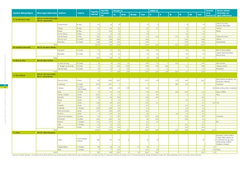
Dominios Hidrogeológicos Masas Aguas Subterráneas Acuíferos Comarca<br />
Superficie<br />
total km 2<br />
Superficie Entradas (1) Salidas (2) Variación<br />
Permeable<br />
<strong>de</strong> <strong>la</strong>s<br />
km 2 ILL IR+EL Rb+Rab Total B R DL M SM Total<br />
Reservas (3)<br />
Núcleos urbanos<br />
abastecidos con<br />
aguas subterráneas<br />
07. Serrel<strong>la</strong>-Aixorta-Algar<br />
080.178. Serrel<strong>la</strong>-Aixorta-Algar<br />
080.922. impermeable<br />
Carrascal-Ferrer M. Baja 61 42 14 14 6 8 14<br />
Callosa d’En Sarrià,<br />
Consorcio Marina Baja<br />
Tárbena M. Baja 6,3 5,76 0,5 0,5 0,1 0,4 0,5 Tàrbena<br />
Bolul<strong>la</strong> M. Baja 7,1 6,24 1,5 1,5 1,5 1,5 Bolul<strong>la</strong><br />
De los Chorros M. Baja 1,9 1,9 0,4 0,4 0,4 0,4<br />
Serrel<strong>la</strong>-Aixorta M. Baja 24,5 16,25 5,3 5,3 0,15 3,25 1,9 5,3 Callosa d’En Sarrià<br />
Plá <strong>de</strong> <strong>la</strong> Casa El Comtat 0,66 0,66 0,04 0,04 0,04 0,04 Facheca<br />
Peña Moro El Comtat 0,99 0,99 0,05 0,05 0,05 0,05 Quatreton<strong>de</strong>ta<br />
Suma 102,45 73,8 21,79 21,79 6,25 3,25 12,29 21,79<br />
08. Volcadores-Benica<strong>de</strong>ll 080.161. Vocadores-Albaida<br />
Volcadores El Comtat 51 7,2 0,9 0,9 0,7 0,2 0,9 Muro <strong>de</strong> Alcoy, Alfafara<br />
Benica<strong>de</strong>ll El Comtat 5,6 5,6 0,7 0,7 0,2 0,5 0,7<br />
Gaianes, Alcocer <strong>de</strong> P<strong>la</strong>nes,<br />
Muro <strong>de</strong> Alcoy<br />
Suma 56,6 12,8 1,6 1,6 0,9 0,7 1,6<br />
09. Muro <strong>de</strong> Alcoy 080.169. Muro <strong>de</strong> Alcoy<br />
Ac. Muro <strong>de</strong> Alcoy El Comtat 8 8 1,34 1,6 2,94 1,4 1 0,54 2,94 Muro <strong>de</strong> Alcoi<br />
Ac. Margen Izq. Río Serpis El Comtat 11 11 0,35 0,54 0,89 0,15 0,64 0,1 0,89 L’Alqueria d’Asnar<br />
Valle <strong>de</strong>l Serpis El Comtat 52 52 2 0,2 2,2 1 1,2 2,2 Benimarfull<br />
Suma 71 71 3,69 2,34 6,03 2,55 2,84 0,54 0,1 6,03<br />
10. Sierra Mario<strong>la</strong><br />
080.170. Salt. San Cristóbal<br />
080.171. Sierra Mario<strong>la</strong><br />
Pinar <strong>de</strong> Camús L´Alcoiá 134 79,65 10,23 10,23 4,8 1,79 3,64 10,23<br />
Alcoy, Banyeres <strong>de</strong> Mario<strong>la</strong>, Onil,<br />
Bocairente ( Valencia)<br />
Cocentaina El Comtat 15,24 10,67 2 2 0,66 1,34 2 Cocentaina<br />
Cabranta<br />
El Comtat<br />
y Alto Vinalopó<br />
212 8,89 1,25 1,79 3,04 4 4 -0,96 Muro <strong>de</strong> Alcoy, Biar y Cocentaina<br />
Agres El Comtat 10 9,1 1,55 1,55 0,07 0,94 0,54 1,55 Agres y Alfafara<br />
Salt-San Cristóbal L´Alcoiá 53,54 13 1,4 1,4 0,3 1,1 1,4 Alcoy<br />
Bara<strong>de</strong>llo L´Alcoiá 3,34 0,8 0,04 0,04 0,04 0,04<br />
Biscoy L´Alcoiá 4 3 0,2 0,2 0,2 0,2<br />
Onil L´Alcoiá 3,59 2,8 0,35 0,35 0,1 0,1 0,25 Onil<br />
Favanel<strong>la</strong> L´Alcoiá 1,5 1,5 0,13 0,13 0,13 0,13<br />
Fontanel<strong>la</strong> A. Vinalopó 8,18 4,04 0,3 0,3 0,3 0,3<br />
Pinar <strong>de</strong> <strong>la</strong> Umbría L´Alcoiá 5,97 4,95 0,35 0,35 0,35 0,35<br />
Reconco L´Alcoiá 7 6,15 0,5 0,5 0,4 0,1 0,5<br />
Terciario <strong>de</strong> Cocentaina El Comtat 3,5 1,2 0,07 0,07 0,05 0,02 0,07 Cocentaina<br />
El Estrecho El Comtat 6,93 6,93 0,3 0,3 0,25 0,05 0,3<br />
Rosario A. Vinalopó 2,47 2,47 0,2 0,2 0,2 0,2 Biar<br />
Laler A. Vinalopó 1,4 1,4 0,17 0,17 0,17 0,17<br />
Banyeres L´Alcoiá 1,25 1,25 0,14 0,14 0,14 0,14<br />
Suma 473,91 157,8 19,18 1,79 20,97 9,81 3,79 8,08 21,68 -0,71<br />
11. So<strong>la</strong>na 080.160. Villena-Benejama<br />
So<strong>la</strong>na<br />
A y M. Vinalopó,<br />
L´A<strong>la</strong>cantí<br />
280 275 30 4 34 35 35 -1<br />
Cau<strong>de</strong>te-Villena A. Vinalopó 68 68 3,4 1,5 4,9 5 5 -0,1<br />
Rocín A. Vinalopó 5 5 0,35 0,35 0,5 0,5 -0,15 Villena<br />
Suma 353 348 33,75 4 1,5 39,25 40,5 40,5 -1,25<br />
Leyenda (1) Entradas (hm 3 /año) : ILL=infiltración lluvia; IR+EL=infiltración ríos+entradas <strong>la</strong>terales; Rr+Rab= Retornos riegos y abastecimiento. (2) Salidas (hm 3 /año): B= extracciones artificiales; R= drenaje a ríos; DL= Drenajes <strong>la</strong>terales; M= drenajes manantiales y fuentes; SM; Salidas subterráneas al mar. (3) Variación reservas (hm 3 /año)<br />
Beneixama, Campo <strong>de</strong> Mirra,<br />
Cañada, Villena, a<strong>de</strong>más <strong>de</strong><br />
<strong>la</strong> exportación <strong>de</strong> agua para<br />
abastecimiento al Medio<br />
Vinalopó y L’A<strong>la</strong>cantí.