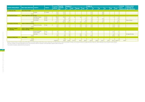
Dominios Hidrogeológicos Masas Aguas Subterráneas Acuíferos Comarca Superficie total km 2 Superficie Entradas (1) Salidas (2) Variación Permeable <strong>de</strong> <strong>la</strong>s km 2 ILL IR+EL Rb+Rab Total B R DL M SM Total Reservas (3) Núcleos urbanos abastecidos con aguas subterráneas 19. Argueña- Maigmó 080.182. Argueña-Maigmó Casa Turriá L´Alcoiá 4,6 3,68 0,45 0,45 0,65 0,65 -0,2 Puntal <strong>de</strong> los Carros A. Vinalopó 8,15 8,15 0,55 0,55 0,3 0,25 0,55 Carrasquil<strong>la</strong>-Peña Chico A. Vinalopó 4,68 4,18 0,3 0,25 0,55 0,95 0,95 -0,4 Sax Los Molinos A. Vinalopó 7,98 7,96 0,2 0,2 0,2 0,2 Loma <strong>de</strong>l Higueral A. Vinalopó 1,65 0,22 0,09 0,09 0,2 0,2 -0,11 Sax Conejera A. Vinalopó 17,56 8,64 0,5 0,5 0,3 0,21 0,51 -0,01 Arenal M. Vinalopó 7,18 0,99 0,03 0,03 0,03 0,03 Petrer Voltes L´Alcoiá 9,65 9,65 0,5 0,5 0,7 0,7 -0,2 Castal<strong>la</strong> Capra<strong>la</strong> M. Vinalopó 8,7 8,33 0,4 0,4 0,3 0,1 0,4 Rullo M. Vinalopó 3,71 3,71 0,16 0,3 0,46 0,38 0,38 0,08 Petrer Maigmó L´Alcoiá 25,8 10 0,9 0,9 0,9 0,9 Castal<strong>la</strong>, Busot y Agost Caballo-Fraile M. Vinalopó 17,72 14,83 1,1 1,1 0,13 0,13 0,97 Petrer Ponce M. Vinalopó 7,17 3,46 0,25 0,25 0,25 0,25 Cár<strong>de</strong>nes M. Vinalopó 0,84 0,84 0,03 0,03 0,03 0,03 Tabaries M. Vinalopó 2,86 2,06 0,1 0,1 0,1 0,1 Suma 128,25 86,7 5,56 0,55 6,11 4,57 0,76 0,65 5,98 0,13 070.023. Jumil<strong>la</strong>-Yec<strong>la</strong> 20. Jumil<strong>la</strong>-Villena 080.172. Sierra Lacera 080.173. Sierra <strong>de</strong>l Castel<strong>la</strong>r Jumil<strong>la</strong>-Villena (sector <strong>Alicante</strong>) A. Vinalopó, M. Vinalopó; L´A<strong>la</strong>cantí 135 30 2,76 2,39 5,15 30 30 -24,85 Petrer, Agost, Novelda, Mutxamel Suma 135 30 2,76 2,39 5,15 30 30 -24,85 21. Serral Salinas 070.027. Serral-Salinas 080.181. Sierra <strong>de</strong> Salinas Serral-Salinas M. Vinalopó 145 53 4 4 12 12 -8 Pinoso, Elda, Monóvar, La Romana, Salinas, Algueña Cabrera A. Vinalopó 8,9 5,35 0,25 0,25 0,25 0,25 Suma 153,9 58,35 4,25 4,25 12 0,25 12,25 -8 22. Quibas (Provincia) 070.029. Quibas 080.187. Sierra <strong>de</strong> Reclot Quibas M. Vinalopó 179 69,8 3,58 3,58 5,65 0,6 0,06 6,31 -2,73 Monóvar, La Romana Lo Geta M. Vinalopó 1,5 1,5 0,09 0,09 0,09 0,09 Suma 180,5 71,3 3,67 3,67 5,65 0,6 0,15 6,4 -2,73 070.030. Sierra <strong>de</strong> Argallet 23. Crevillente-Argallet 070.031. Sierra <strong>de</strong> Crevillente 080.188. Sierra <strong>de</strong> Argallet 080.189. Sierra <strong>de</strong> Crevillente Crevillente M. Vinalopó 145 76 4 4 10,15 10,15 -6,15 Hondón <strong>de</strong> <strong>la</strong> Nieves, Hondón <strong>de</strong> los Frailes, Orihue<strong>la</strong> Suma 145 76 4 4 10,15 10,15 -6,15 24. Medio Vinalopó y L´A<strong>la</strong>cantí 080.926. Impermeable Cuaternario <strong>de</strong> Elda M. Vinalopó 19 19 0,31 1,14 1,45 0,11 1,34 1,45 Bateig M. Vinalopó 3,8 3,8 0,06 0,06 0,06 0,06 Beties M. Vinalopó 6,7 6,7 0,2 0,2 0,2 0,2 Cuaternario <strong>de</strong> Novelda M. Vinalopó 52,4 51,5 0,46 1 1,46 0,5 0,96 1,46 Horna M. Vinalopó 5 3,5 0,2 0,2 0,2 0,2 Cuaternario <strong>de</strong> San Vicente L´A<strong>la</strong>cantí 72,1 72,1 1,35 2,5 3,85 1,2 2,65 3,85 Mediana L´A<strong>la</strong>cantí 0,9 0,9 0,03 0,03 0,03 0,03 Fontcalent L´A<strong>la</strong>cantí 1,8 1,8 0,08 0,08 0,05 0,03 0,08 Águi<strong>la</strong>s M. Vinalopó 5,2 5,2 0,2 0,2 0,2 0,2 Monforte <strong>de</strong>l Cid Sancho B. Vinalopó 35 29,34 1,15 1,15 1,15 1,15 Suma 201,9 193,84 4,04 1,14 3,5 8,68 2,26 0,96 1,41 1,4 2,65 8,68 Leyenda (1) Entradas (hm 3 /año) : ILL=infiltración lluvia; IR+EL=infiltración ríos+entradas <strong>la</strong>terales; Rr+Rab= Retornos riegos y abastecimiento. (2) Salidas (hm 3 /año): B= extracciones artificiales; R= drenaje a ríos; DL= Drenajes <strong>la</strong>terales; M= drenajes manantiales y fuentes; SM; Salidas subterráneas al mar. (3) Variación reservas (hm 3 /año) Las aguas subterráneas y los acuíferos <strong>de</strong> <strong>la</strong> <strong>provincia</strong> At<strong>la</strong>s <strong>hidrogeológico</strong> <strong>de</strong> <strong>la</strong> <strong>provincia</strong> <strong>de</strong> <strong>Alicante</strong> 07 53
Las aguas subterráneas y los acuíferos <strong>de</strong> <strong>la</strong> <strong>provincia</strong> At<strong>la</strong>s <strong>hidrogeológico</strong> <strong>de</strong> <strong>la</strong> <strong>provincia</strong> <strong>de</strong> <strong>Alicante</strong> 07 54 Dominios Hidrogeológicos Masas Aguas Subterráneas Acuíferos Comarca Superficie total km 2 Superficie Entradas (1) Salidas (2) Variación Permeable <strong>de</strong> <strong>la</strong>s km 2 ILL IR+EL Rb+Rab Total B R DL M SM Total Reservas (3) Núcleos urbanos abastecidos con aguas subterráneas 25. Elche-Santa Po<strong>la</strong> 080.190. Bajo Vinalopó Colmenar B. Vinalopó 27,4 23,75 1 1 0,12 0,88 1 Suma 27,4 23,75 1 1 0,12 0,88 1 26. Vega Baja <strong>de</strong>l Segura 070.036. Vega media y baja <strong>de</strong>l Segura Vega Baja <strong>de</strong>l Segura V. Baja 748,6 748,6 21 10 42 73 15 51 7 73 Sª <strong>de</strong> Orihue<strong>la</strong> V. Baja 25,8 25 1,13 1,13 0,5 0,63 1,13 Sª <strong>de</strong> Callosa V. Baja 11,11 10,45 0,6 0,6 0,3 0,3 0,6 Callosa <strong>de</strong> Segura Suma 785,51 784,05 22,73 10 42 74,73 15,8 51 0,93 7 74,73 27. Terciario <strong>de</strong> Torrevieja 070.042. Terciario <strong>de</strong> Torrevieja Terciario <strong>de</strong> Torrevieja V. Baja 167 13 1,3 4,5 5,8 5,64 0,16 5,8 Suma 167 13 1,3 4,5 5,8 5,64 0,16 5,8 28. Campo <strong>de</strong> Cartagena y Cabo Roig Acuíferos <strong>de</strong> interés local 070.052. Campo <strong>de</strong> Cartagena 070.053. Cabo Roig Campo <strong>de</strong> Cartagena (Sector <strong>Alicante</strong>) V. Baja 94 89 3,5 3,5 3,51 -0,01 3,5 Cabo Roig V.Baja 61 61 1,8 0,6 2,4 3 -0,6 2,4 San Miguel <strong>de</strong> Salinas Suma 155 150 5,3 0,6 5,9 6,51 -0,61 5,9 Impermeables Suma 241 3 3 3 3 TOTALES 5076,074* 3600 335,66 23,15 ** 79,64 438,45 252,50 149,99 3,00** 52,55 26,25 484,29** -45,84 Leyenda (1) Entradas (hm 3 /año): ILL=infiltración lluvia; IR+EL=infiltración ríos+entradas <strong>la</strong>terales; Rr+Rab= Retornos riegos y abastecimiento. (2) Salidas (hm 3 /año): B= extracciones artificiales; R= drenaje a ríos; DL= Drenajes <strong>la</strong>terales; M= drenajes manantiales y fuentes; SM; Salidas subterráneas al mar. (3) Variación reservas (hm 3 /año). * Esta suma correspon<strong>de</strong> a los acuíferos diferenciados como tal. El resto <strong>de</strong> <strong>la</strong> <strong>provincia</strong> (804 km 2 ) correspon<strong>de</strong> a zonas impermeables o pequeños acuíferos <strong>de</strong> interés local. ** Se consi<strong>de</strong>ran <strong>la</strong>s entradas o salidas <strong>la</strong>terales netas <strong>de</strong> <strong>la</strong> <strong>provincia</strong>.