Centre de Recherche sur la Nature, la Forêt et le Bois - Portail ...
Centre de Recherche sur la Nature, la Forêt et le Bois - Portail ...
Centre de Recherche sur la Nature, la Forêt et le Bois - Portail ...

You also want an ePaper? Increase the reach of your titles
YUMPU automatically turns print PDFs into web optimized ePapers that Google loves.
ACTIVITÉS SCIENTIFIQUES<br />
Direction <strong>de</strong> <strong>la</strong> <strong>Nature</strong>, <strong>de</strong> <strong>la</strong> Chasse <strong>et</strong> <strong>de</strong> <strong>la</strong> Pêche<br />
<strong>de</strong> réévaluer <strong>le</strong>s effectifs <strong>de</strong> l'engou<strong>le</strong>vent. Dans<br />
<strong>le</strong> cadre du programme Life “Protection <strong>de</strong>s<br />
habitats <strong>de</strong> <strong>la</strong> mou<strong>le</strong> perlière” obtenu par<br />
<strong>le</strong> CRNFB, l’inventaire actuel <strong>de</strong>s popu<strong>la</strong>tions a<br />
permis <strong>de</strong> cartographier 1.750 mou<strong>le</strong>s perlières<br />
(M. margaritifera) <strong>et</strong> plus <strong>de</strong> 7.000 mul<strong>et</strong>tes<br />
épaisses (Unio crassus). Sur base <strong>de</strong> ces résultats,<br />
<strong>de</strong>s zones sensib<strong>le</strong>s ont été délimitées avec<br />
précision pour chacun <strong>de</strong>s cours d’eau concernés<br />
(vallée <strong>de</strong> <strong>la</strong> Rul<strong>le</strong>s, <strong>de</strong> <strong>la</strong> Haute-Sûre <strong>et</strong> <strong>de</strong> l’Our).<br />
E<strong>la</strong>boration d’arrêtés <strong>de</strong><br />
désignation <strong>de</strong> sites Natura 2000<br />
Afin <strong>de</strong> tester <strong>le</strong>s méthodologies développées,<br />
<strong>le</strong> CRNFB a pris en charge <strong>la</strong> réalisation d'un<br />
certain nombre <strong>de</strong> proj<strong>et</strong>s d'arrêtés <strong>de</strong> désignation<br />
<strong>de</strong> sites Natura 2000 <strong>et</strong> <strong>la</strong> finalisation <strong>de</strong> ceux<br />
réalisés par <strong>le</strong>s équipes universitaires. Ce<strong>la</strong> suppose<br />
au préa<strong>la</strong>b<strong>le</strong> une cartographie détaillée <strong>de</strong>s habitats<br />
<strong>et</strong> <strong>de</strong>s habitats d'espèces, un diagnostic <strong>sur</strong> <strong>le</strong>ur<br />
état <strong>de</strong> conservation, <strong>la</strong> définition d'objectifs <strong>de</strong><br />
conservation <strong>et</strong> l'i<strong>de</strong>ntification <strong>de</strong>s contraintes <strong>et</strong><br />
<strong>de</strong>s moyens pour maintenir un état <strong>de</strong> conservation<br />
favorab<strong>le</strong>.<br />
A <strong>la</strong> fin 2004, <strong>de</strong>s proj<strong>et</strong>s provisoires d'arrêtés sont<br />
proposés pour:<br />
❚❚ <strong>le</strong> camp militaire d'Elsenborn (2.500 ha);<br />
❚❚ <strong>le</strong> camp militaire <strong>de</strong> Lag<strong>la</strong>nd (2.500 ha);<br />
❚❚ <strong>la</strong> p<strong>la</strong>ine <strong>de</strong> Ny (150 ha);<br />
❚❚ <strong>le</strong> bassin <strong>de</strong> l’Herm<strong>et</strong>on en aval <strong>de</strong> Vo<strong>de</strong>lée<br />
❚❚ (1.000 ha);<br />
❚❚ <strong>le</strong>s bois d'Enghien <strong>et</strong> <strong>de</strong> Silly (600 ha);<br />
❚❚ <strong>le</strong> bassin <strong>de</strong> <strong>la</strong> Lesse entre Vil<strong>le</strong>rs-<strong>sur</strong>-Lesse<br />
❚❚ <strong>et</strong> Chanly (2.600 ha).<br />
Comme il s'agit <strong>de</strong>s premiers arrêtés, ces documents<br />
font l'obj<strong>et</strong> <strong>de</strong> nombreuses discussions <strong>et</strong> révisions<br />
avec l'ai<strong>de</strong> d'autres administrations (DNF <strong>et</strong> DGA<br />
notamment) pour as<strong>sur</strong>er <strong>la</strong> cohérence <strong>de</strong>s me<strong>sur</strong>es<br />
proposées. Par ail<strong>le</strong>urs, <strong>de</strong>s inventaires détaillés<br />
ont été réalisés dans <strong>la</strong> Vallée <strong>de</strong> l'Ourthe, <strong>de</strong><br />
<strong>la</strong> Haute-Semois, dans <strong>la</strong> Vallée <strong>de</strong> l'Escaut <strong>et</strong> dans<br />
<strong>le</strong> camp militaire <strong>de</strong> Marche-en-Famenne.<br />
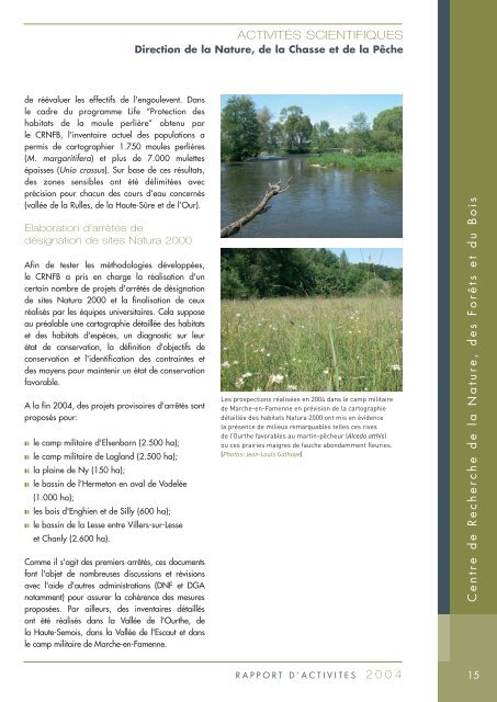
Les prospections réalisées en 2004 dans <strong>le</strong> camp militaire<br />
<strong>de</strong> Marche-en-Famenne en prévision <strong>de</strong> <strong>la</strong> cartographie<br />
détaillée <strong>de</strong>s habitats Natura 2000 ont mis en évi<strong>de</strong>nce<br />
<strong>la</strong> présence <strong>de</strong> milieux remarquab<strong>le</strong>s tel<strong>le</strong>s ces rives<br />
<strong>de</strong> l’Ourthe favorab<strong>le</strong>s au martin-pêcheur (Alcedo atthis)<br />
ou ces prairies maigres <strong>de</strong> fauche abondamment f<strong>le</strong>uries.<br />
(Photos: Jean-Louis Gathoye)<br />
<strong>Centre</strong> <strong>de</strong> <strong>Recherche</strong> <strong>de</strong> <strong>la</strong> <strong>Nature</strong>, <strong>de</strong>s Forêts <strong>et</strong> du <strong>Bois</strong><br />
RAPPORT D’ACTIVITES 2004<br />
15