binoche renaud giquello - Loeb Larocque
binoche renaud giquello - Loeb Larocque
binoche renaud giquello - Loeb Larocque

You also want an ePaper? Increase the reach of your titles
YUMPU automatically turns print PDFs into web optimized ePapers that Google loves.
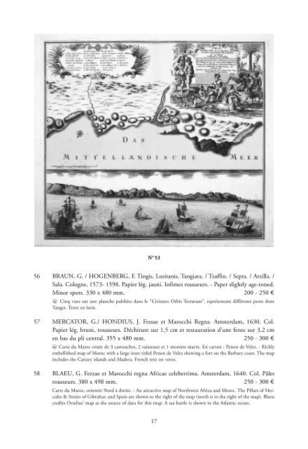
N o 53<br />
56 BRAUN, G. / HOGENBERG, F. Tingis, Lusitanis, Tangiara. / Tzaffin. / Septa. / Arzilla. /<br />
Sala. Cologne, 1573- 1598. Papier lég. jauni. Infimes rousseurs. - Paper slightly age-toned.<br />
Minor spots. 330 x 480 mm. 200 - 250 ¤<br />
wo Cinq vues sur une planche publiées dans le “Civitates Orbis Terrarum”, représentant différents ports dont<br />
Tanger. Texte en latin.<br />
57 MERCATOR, G./ HONDIUS, J. Fessae et Marocchi Regna. Amsterdam, 1630. Col.<br />
Papier lég. bruni, rousseurs. Déchirure sur 1,5 cm et restauration d’une fente sur 3,2 cm<br />
en bas du pli central. 355 x 480 mm. 250 - 300 ¤<br />
wo Carte du Maroc ornée de 3 cartouches, 2 vaisseaux et 1 monstre marin. En carton : Penon de Velez. - Richly<br />
embellished map of Moroc with a large inset titled Penon de Velez showing a fort on the Barbary coast. The map<br />
includes the Canary islands and Madera. French text on verso.<br />
58 BLAEU, G. Fezzae et Marocchi regna Africae celeberrima. Amsterdam, 1640. Col. Pâles<br />
rousseurs. 380 x 498 mm. 250 - 300 ¤<br />
Carte du Maroc, orientée Nord à droite. - An attractive map of Northwest Africa and Moroc. The Pillars of Hercules<br />
& Straits of Gibraltar, and Spain are shown to the right of the map (north is to the right of the map). Blaeu<br />
credits Ortelius’ map as the source of data for this map. A sea battle is shown in the Atlantic ocean.<br />
17