binoche renaud giquello - Loeb Larocque
binoche renaud giquello - Loeb Larocque
binoche renaud giquello - Loeb Larocque

You also want an ePaper? Increase the reach of your titles
YUMPU automatically turns print PDFs into web optimized ePapers that Google loves.
AMÉRIQUE SEPTENTRIONALE<br />
75 SANSON, N. Amerique Septentrionale. Paris, Mariette, 1650. Beau col. ancien. Rousseurs,<br />
pâles mouillures, fente en bas du pli central (sans manque). Bordures et cartouches<br />
coloriés à l’époque. - Paper slightly age toned, split in lower part centerfold, minor water<br />
staining and brown spotting. 390 x 553 mm. 1600 - 2000 ¤<br />
wo 3e état. Carte de l’ Amérique Septentrionale gravée par A. Peyrounin, avec les bordures et cartouches coloriés<br />
à l’époque. - Third state. Map of North America with scale borders and title-cartouches brightly coloured at the<br />
time of publication. The map is engraved by Peyrounin. The North America is one of the most desirable seventeenth<br />
century maps and certainly one of the most influential for many years. It was the first map to show all five<br />
Great Lakes, which are open-ended to the west and the first to name Lake Superior and Lake Ontario. It’s information<br />
on Indians in the Southwest was the most up to date at the time, especially for the Apache tribes, many<br />
of which are indicated here for the first time. California with flat northern coast sloping up to the east. The<br />
Azores are included, Lake Ontario is shaded. The colouring is uncommon, curious and very decorative. -<br />
McLaughlin, California,12, State 3 ; Wagner 360 ; Burden, North America, 294, state 3.<br />
76 BOWEN, E. A New General Map of America / A New.. the North Pole.. / A New.. Mexico<br />
or New Spain.. / Londres, 1747. Col. ancien. Petite fente restaurée (3 cm) en bas à gauche<br />
d’une carte. Infimes rousseurs. Déchirure sur 5 cm en haut à gauche d’une carte. - The map<br />
of the North Pole with a repaired terar, 3 cm into engraved area. Map of America with a<br />
large tear upper part left, 5 cm into engraved area. Orig. col. 358 x 425 mm. 800 - 900 ¤<br />
wo Lot de 3 cartes illustrant respectivement l’Amérique, le Mexique et le Pôle Nord. - Three maps by E. Bowen<br />
respectively depicting the American continent, Mexico and the North Pole. Map of Mexico with inset of<br />
Gallapagos islands. Text in California gives credit to Father Kino for discovering this is a peninsula.<br />
77 JEFFERYS, T. An Exact Chart of the River St. Laurence.. Quebec. Londres, Robert Sayer,<br />
1775. Limites coloriées. Carte pliée, imprimée sur 2 feuilles jointes. Petites fentes aux<br />
extrémités des plis dont une jusque sur 0,5 cm à l’int. de la carte. Petit trou à 2 intersections,<br />
2 taches pâles au milieu. - Two sheets joined, 2 spots slightly brown in the center. In<br />
outline colours. 600 x 950 mm. 700 - 800 ¤<br />
wo Grande carte illustrant l’estuaire de la rivière St. Laurent. Accompagné de 5 cartons représentant des tracés de<br />
côtes le long du Golfe homonyme.<br />
- With five insets. A chart of the St. Lawrence River by the noted eighteenth century English cartographer<br />
Thomas Jefferys, Geographer to George III and the Prince of Wales. Jefferys produced many important maps of<br />
America from 1751 until 1768, including this superior chart first issued in 1757. The main source for Jefferys<br />
was a map issued in 1702 based on a survey of the river by Jean Deshayes. Deshayes map became the standard<br />
chart of the St. Lawrence until James Cook’s surveys appeared in the second half of the century. Jefferys translated<br />
Deshayes’ chart into English, and added an updated depiction of the river from Lake Ontario to Quebec<br />
based on J.B.B. D’Anville’s 1755 map of Canada.<br />
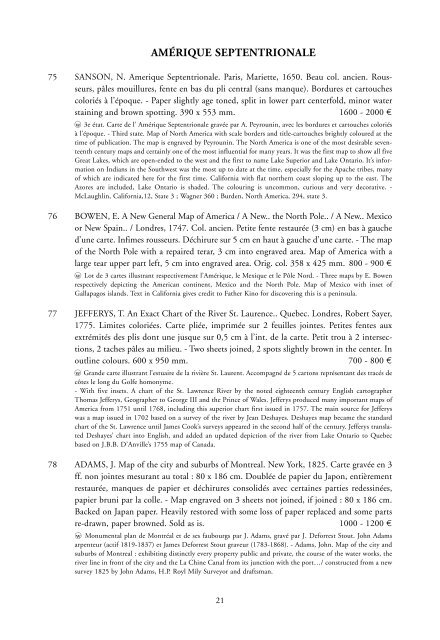
78 ADAMS, J. Map of the city and suburbs of Montreal. New York, 1825. Carte gravée en 3<br />
ff. non jointes mesurant au total : 80 x 186 cm. Doublée de papier du Japon, entièrement<br />
restaurée, manques de papier et déchirures consolidés avec certaines parties redessinées,<br />
papier bruni par la colle. - Map engraved on 3 sheets not joined, if joined : 80 x 186 cm.<br />
Backed on Japan paper. Heavily restored with some loss of paper replaced and some parts<br />
re-drawn, paper browned. Sold as is. 1000 - 1200 ¤<br />
wo Monumental plan de Montréal et de ses faubourgs par J. Adams, gravé par J. Deforrest Stout. John Adams<br />
arpenteur (actif 1819-1837) et James Deforrest Stout graveur (1783-1868). - Adams, John. Map of the city and<br />
suburbs of Montreal : exhibiting distinctly every property public and private, the course of the water works, the<br />
river line in front of the city and the La Chine Canal from its junction with the port…/ constructed from a new<br />
survey 1825 by John Adams, H.P. Royl Mily Surveyor and draftsman.<br />
21