binoche renaud giquello - Loeb Larocque
binoche renaud giquello - Loeb Larocque
binoche renaud giquello - Loeb Larocque

You also want an ePaper? Increase the reach of your titles
YUMPU automatically turns print PDFs into web optimized ePapers that Google loves.
95 (TURQUIE). Turquie d’Europe / Turquie européenne / Turquie d’Europe et d’Asie. Paris,<br />
1755 à 1828. Limites en col. d’époque. Bon état général In-folio à gr. in-folio. 100 - 150 ¤<br />
Lot de 3 cartes par : Janvier, Vaugondy et Hérisson. Avec l’île de chypre sur les cartes de Janvier et Hérisson.<br />
96 TIRINUS, J. Chorographia Terrae Sanctae in Angustiorem Forman Redacta.. Anvers,<br />
1632. Belle impression. Pâle mouillure le long du pli central, marge inf. renmargée sur 9<br />
cm. - Two sheets joined as issued. Slightly waterstaining along centerfold, 9 cm of low margin<br />
replaced. 325 x 820 mm. 800 - 1000 ¤<br />
wo Large map of the Holy Land surrounded with panels of vignettes displaying sacred objects including a menorah,<br />
the arc of the covenant, the altar of sacrifices, the Tabernacle, and a plan and elevations of the Temple. At<br />
center is an inset bird’s-eye plan of ancient Jerusalem based on the Spanish biblical geographer, Juan Bautista<br />
Vilalpando. Oriented with east at top, the map includes the territories of the twelve tribes on both sides of the<br />
Jordan River and the route of the Exodus and Wandering. - Laor 771.<br />
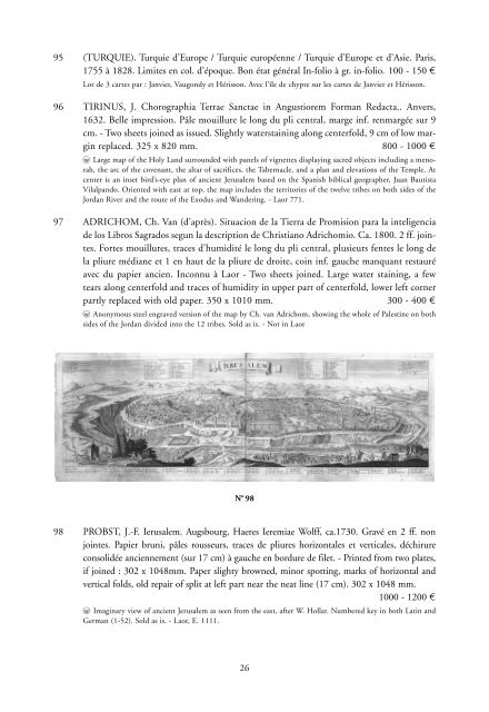
97 ADRICHOM, Ch. Van (d’après). Situacion de la Tierra de Promision para la inteligencia<br />
de los Libros Sagrados segun la description de Christiano Adrichomio. Ca. 1800. 2 ff. jointes.<br />
Fortes mouillures, traces d’humidité le long du pli central, plusieurs fentes le long de<br />
la pliure médiane et 1 en haut de la pliure de droite, coin inf. gauche manquant restauré<br />
avec du papier ancien. Inconnu à Laor - Two sheets joined. Large water staining, a few<br />
tears along centerfold and traces of humidity in upper part of centerfold, lower left corner<br />
partly replaced with old paper. 350 x 1010 mm. 300 - 400 ¤<br />
wo Anonymous steel engraved version of the map by Ch. van Adrichom, showing the whole of Palestine on both<br />
sides of the Jordan divided into the 12 tribes. Sold as is. - Not in Laor<br />
N o 98<br />
98 PROBST, J.-F. Ierusalem. Augsbourg, Haeres Ieremiae Wolff, ca.1730. Gravé en 2 ff. non<br />
jointes. Papier bruni, pâles rousseurs, traces de pliures horizontales et verticales, déchirure<br />
consolidée anciennement (sur 17 cm) à gauche en bordure de filet. - Printed from two plates,<br />
if joined : 302 x 1048mm. Paper slighty browned, minor spotting, marks of horizontal and<br />
vertical folds, old repair of split at left part near the neat line (17 cm). 302 x 1048 mm.<br />
1000 - 1200 ¤<br />
wo Imaginary view of ancient Jerusalem as seen from the east, after W. Hollar. Numbered key in both Latin and<br />
German (1-52). Sold as is. - Laor, E. 1111.<br />
26