binoche renaud giquello - Loeb Larocque
binoche renaud giquello - Loeb Larocque
binoche renaud giquello - Loeb Larocque

Create successful ePaper yourself
Turn your PDF publications into a flip-book with our unique Google optimized e-Paper software.
water staining and brown spotting, water staining at left and right part. 390 x 553 mm.<br />
400 - 600 ¤<br />
wo Carte d’Europe gravée par A. Peyrounin, avec les bordures et cartouches coloriés à l’époque. - Map of Europe<br />
with scale borders and title-cartouches brightly coloured at the time of publication. The map is engraved by<br />
Peyrounin. The colouring is uncommon, curious and very decorative.<br />
ALLEMAGNE - SUISSE<br />
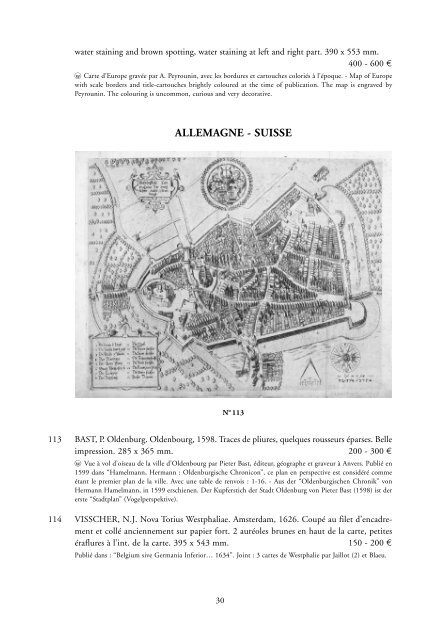
N o 113<br />
113 BAST, P. Oldenburg. Oldenbourg, 1598. Traces de pliures, quelques rousseurs éparses. Belle<br />
impression. 285 x 365 mm. 200 - 300 ¤<br />
wo Vue à vol d’oiseau de la ville d’Oldenbourg par Pieter Bast, éditeur, géographe et graveur à Anvers. Publié en<br />
1599 dans “Hamelmann, Hermann : Oldenburgische Chronicon”, ce plan en perspective est considéré comme<br />
étant le premier plan de la ville. Avec une table de renvois : 1-16. - Aus der “Oldenburgischen Chronik” von<br />
Hermann Hamelmann, in 1599 erschienen. Der Kupferstich der Stadt Oldenburg von Pieter Bast (1598) ist der<br />
erste “Stadtplan” (Vogelperspektive).<br />
114 VISSCHER, N.J. Nova Totius Westphaliae. Amsterdam, 1626. Coupé au filet d’encadrement<br />
et collé anciennement sur papier fort. 2 auréoles brunes en haut de la carte, petites<br />
éraflures à l’int. de la carte. 395 x 543 mm. 150 - 200 ¤<br />
Publié dans : “Belgium sive Germania Inferior… 1634”. Joint : 3 cartes de Westphalie par Jaillot (2) et Blaeu.<br />
30