binoche renaud giquello - Loeb Larocque
binoche renaud giquello - Loeb Larocque
binoche renaud giquello - Loeb Larocque

Create successful ePaper yourself
Turn your PDF publications into a flip-book with our unique Google optimized e-Paper software.
wo Premier état. - First state. Separate publication. Desgranges was a minor French mapmaker at the end of the 17th<br />
century. His output was small, and only maps of Germany and Palestine and Greece by him have been traced in<br />
addition to this one.The map carries the signature of Roussel, who engraved the map, and of Dolivart, who<br />
engraved the elaborate cartouche. The significance of the symbolic cartouche lies in the date 1689, the year in<br />
which Louis XIV declared war on England in support of the deposed Catholic monarch James II”. Insets of the<br />
Channel and of the Faroe and Shetland Islands. Below the latter is a panel of text recounting the overseas possessions<br />
and forts of the English in America, the West Indies, Africa and Asia. - Shirley, British Isles, 1650- 1750,<br />
p.51, state 1.<br />
145 SPEED, J. Midle-Sex Described with the Most Famous Cities of London and Westminster.<br />
Londres, Sudbury & Humble, 1610 (1616). Superbe exemplaire dans une très belle<br />
impression. - Dark and strong impression. 380 x 505 mm. 1000 - 1500 ¤<br />
wo Latin edition. Speed’s version of Norden’s map engraved by Hondius. With inset plans of London, Westminster,<br />
and inset illustrations of St. Peter’s and St. Paul’s. From : “The Theatre of the Empire of Great Britaine… “. The<br />
Latin edition is arguably the rarest of all editions, being produced for the overseas market.<br />
ESPAGNE - PORTUGAL<br />
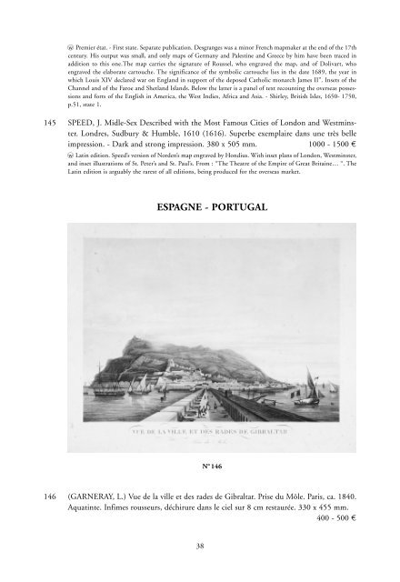
N o 146<br />
146 (GARNERAY, L.) Vue de la ville et des rades de Gibraltar. Prise du Môle. Paris, ca. 1840.<br />
Aquatinte. Infimes rousseurs, déchirure dans le ciel sur 8 cm restaurée. 330 x 455 mm.<br />
400 - 500 ¤<br />
38