Légende de plan cadastral
Légende de plan cadastral
Légende de plan cadastral

Create successful ePaper yourself
Turn your PDF publications into a flip-book with our unique Google optimized e-Paper software.
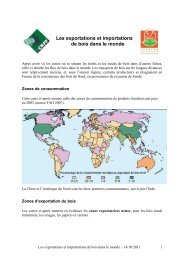
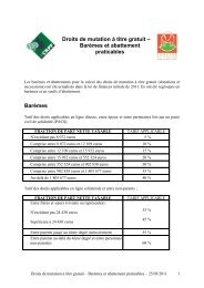
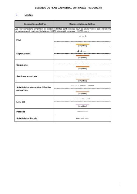
LEGENDE DU PLAN CADASTRAL SUR CADASTRE.GOUV.FRILimitesDésignation <strong>cadastral</strong>eReprésentation <strong>cadastral</strong>eLes représentations simplifiées <strong>de</strong> certaines limites sont utilisées pour les <strong>plan</strong>s vecteur dans la fenêtrecartographique à partir <strong>de</strong> l’échelle du 1/1250 et au-<strong>de</strong>là (exemple : 1/1500, etc.)Etat(simplifiée)Département(simplifiée)Commune(simplifiée)Section <strong>cadastral</strong>e(simplifiée)Subdivision <strong>de</strong> section / Feuille<strong>cadastral</strong>e(simplifiée)Lieu-dit(simplifiée)ParcelleSubdivision fiscale1
IIDétails topographiquesDésignation <strong>cadastral</strong>eReprésentation <strong>cadastral</strong>eLimite ne formant pas parcelle(<strong>plan</strong> vecteur))Terrain <strong>de</strong> sports, petit ruisseau,trottoir (<strong>plan</strong> vecteur)Parking, terrasse (<strong>plan</strong> vecteur)Surface ne formant pas parcelleet détail topographique (<strong>plan</strong> image)Talus (<strong>plan</strong> image)PylônePuits2
IIIClôturesDésignation <strong>cadastral</strong>eReprésentation <strong>cadastral</strong>eMur mitoyenMur non mitoyenFossé mitoyenFossé non mitoyenClôture mitoyenneClôture non mitoyenneHaie mitoyenneHaie non mitoyenne3
IVVoies <strong>de</strong> communicationDésignation <strong>cadastral</strong>eReprésentation <strong>cadastral</strong>eCheminChemin ne formant pas parcellemitoyenChemin ne formant pas parcellenon mitoyenLimite <strong>de</strong> chaussée avec trottoirsSentierChemin <strong>de</strong> fer à une voieGazoduc ou oléoducAqueducTéléphériqueLigne <strong>de</strong> transport <strong>de</strong> force(<strong>plan</strong> vecteur)(<strong>plan</strong> image)4
VHydrographieDésignation <strong>cadastral</strong>eReprésentation <strong>cadastral</strong>e(<strong>plan</strong> vecteur)Pont(<strong>plan</strong> image)Etang, lac et cours d’eau (<strong>plan</strong>vecteur)Piscine (<strong>plan</strong> vecteur)Cours d’eau (<strong>plan</strong> image)Etang, lac, pièce d’eau et piscine(<strong>plan</strong> image)(formant parcelle)(ne formant pasparcelle)Petit ruisseauRuisseau, ravin ou torrent parfoisà sec5
VIConstructionsDésignation <strong>cadastral</strong>eReprésentation <strong>cadastral</strong>eBâtiment dur (exemple : maison)(<strong>plan</strong> vecteur)(<strong>plan</strong> image)Bâtiment léger (exemple : hangar)(<strong>plan</strong> vecteur)(<strong>plan</strong> image)Bâtiment en ruineEgliseMosquéeSynagogueCimetièreCimetière musulmanCimetière israélite6
VIIBornes et repèresDésignation <strong>cadastral</strong>eReprésentation <strong>cadastral</strong>ePoint géodésique bornéPoint géodésique non bornéPoint <strong>de</strong> canevas d’ensemblebornéPoint <strong>de</strong> canevas d’ensemble nonbornéPoint <strong>de</strong> polygonationRepéréRepère N.G.F.Borne du N.G.F.Nivellement M.R.L.Autre repère <strong>de</strong> NivellementBorne limite <strong>de</strong> CommuneCroix gravée⊗(<strong>plan</strong> vecteur)(<strong>plan</strong> image)Boulon scelléBorne <strong>de</strong> propriétéCalvaire7
VIIIAutres symbolesDésignation <strong>cadastral</strong>eReprésentation <strong>cadastral</strong>eFlèche <strong>de</strong> rattachement d’unnuméro <strong>de</strong> parcelle ou <strong>de</strong> laréférence d’un bâtiment surdomaine non cadastréHalteArrêtStationLimite contestée(signe conventionnel particulier à l’Alsace Mosellepour les <strong>plan</strong>s image)Limite <strong>de</strong> nature <strong>de</strong> culture(signe conventionnel particulier à l’Alsace Mosellepour les <strong>plan</strong>s image))Limite <strong>de</strong> charge ou servitu<strong>de</strong>s(signe conventionnel particulier à l’AlsaceMoselle pour les <strong>plan</strong>s image)Drapeau (parcelle en instance d'une miseà jour graphique)Localisant parcellaire (<strong>plan</strong> image)Localisant <strong>de</strong> voisinage (<strong>plan</strong> image)Localisant <strong>de</strong> repérage (<strong>plan</strong> image)8