Scarica la guida in PDF - Le Strade dei Parchi
Scarica la guida in PDF - Le Strade dei Parchi
Scarica la guida in PDF - Le Strade dei Parchi

You also want an ePaper? Increase the reach of your titles
YUMPU automatically turns print PDFs into web optimized ePapers that Google loves.
Assessorato Ambiente e<br />
Cooperazione tra i Popoli<br />
LE STRADE<br />
DEI PARCHI<br />
It<strong>in</strong>erari nelle Aree Protette del Lazio<br />
It<strong>in</strong>erario delle forre etrusche<br />
e del<strong>la</strong> valle del Tevere<br />
It<strong>in</strong>erary of the Etruscan canyons and the Tiber Valley<br />
GUIDA<br />
GUIDE
REGIONE LAZIO<br />
Assessorato Ambiente e Cooperazione tra i Popoli<br />
Assessore Ambiente e Cooperazione tra i Popoli<br />
Filiberto Zaratti<br />
Direttore Regionale Ambiente e Cooperazione tra i Popoli<br />
Giovanna Bargagna<br />
Direttore Area Conservazione del<strong>la</strong> Natura<br />
C<strong>la</strong>udio Cattena<br />
Agenzia Regionale per i <strong>Parchi</strong> - ARP<br />
Direttore<br />
Vito Consoli<br />
Dirigente del Settore Pianificazione<br />
Silvia M. Mont<strong>in</strong>aro<br />
Coord<strong>in</strong>amento del progetto<br />
“<strong>Le</strong> strade <strong>dei</strong> parchi”<br />
Anna Maria Basso<br />
Coord<strong>in</strong>amento editoriale<br />
Isabel<strong>la</strong> Egidi<br />
Testi<br />
Giulio Ie<strong>la</strong>rdi<br />
Traduzioni<br />
Shirli Ouimette<br />
Illustrazioni<br />
Federico Gemma<br />
Materiale fotografico<br />
Maurizio Lupi<br />
Archivio ARP<br />
Filippo Belisario<br />
Progetto<br />
Raffael<strong>la</strong> Gemma<br />
Realizzazione grafica e stampa<br />
Rapidagraph<br />
Hanno col<strong>la</strong>borato al<strong>la</strong> realizzazione:<br />
ARP<br />
Nicoletta Cutolo, Cristiano Fattori,<br />
Dario Manc<strong>in</strong>el<strong>la</strong>, Cesare<br />
Pierdom<strong>in</strong>ici, Luigi Quattr<strong>in</strong><br />
Riserva Nazzano Tevere Farfa<br />
Concetta Paternò<br />
Riserva Monte Soratte<br />
Lanfranco Marchetti<br />
Parco valle del Treja<br />
Valeria Garg<strong>in</strong>i, Gianni Guaita,<br />
Marcello Lorenzi<br />
Si r<strong>in</strong>graziano <strong>in</strong>oltre:<br />
Stefano Cresta, C<strong>la</strong>udio Di Giovannantonio,<br />
Umberto Pesso<strong>la</strong>no<br />
e tutto il personale delle aree protette<br />
che ha partecipato al progetto
“L<br />
e <strong>Strade</strong> <strong>dei</strong> <strong>Parchi</strong>" è un progetto di promozione di it<strong>in</strong>erari<br />
naturalistici nei <strong>Parchi</strong> del Lazio, nato dall'idea che le<br />
aree naturali protette del<strong>la</strong> Regione possano costituire un<br />
sistema <strong>in</strong>terconnesso, non solo ai f<strong>in</strong>i del<strong>la</strong> conservazione del<strong>la</strong><br />
natura e del<strong>la</strong> biodiversità, ma anche per <strong>la</strong> fruizione ai cittad<strong>in</strong>i<br />
attraverso il turismo sostenibile.<br />
Sul<strong>la</strong> base del<strong>la</strong> programmazione dell'Assessorato Ambiente e<br />
Cooperazione tra i Popoli, l'Agenzia Regionale <strong>Parchi</strong> ha<br />
realizzato una serie di it<strong>in</strong>erari del sistema regionale delle Aree<br />
Naturali Protette.<br />
Sono c<strong>in</strong>que, a oggi, gli <strong>in</strong>terventi realizzati: l'It<strong>in</strong>erario del<br />
Lazio Etrusco, che parte da Roma e giunge ad Acquapendente<br />
ripercorrendo le vestigia degli antichi popoli <strong>la</strong>ziali; l'It<strong>in</strong>erario<br />
<strong>dei</strong> <strong>Parchi</strong> Montani, un lungo viaggio al<strong>la</strong> scoperta delle meraviglie<br />
del<strong>la</strong> dorsale appenn<strong>in</strong>ica; l' It<strong>in</strong>erario delle forre etrusche e del<strong>la</strong><br />
valle del Tevere, per conoscere i paesaggi fluviali e i caratteristici<br />
borghi che si affacciano sul<strong>la</strong> valle del Tevere; l'It<strong>in</strong>erario<br />
geologico Cim<strong>in</strong>o-Vicano, che vede protagoniste le rocce e <strong>la</strong><br />
primitiva attività vulcanica dell'Alto Lazio e <strong>in</strong>f<strong>in</strong>e l'It<strong>in</strong>erario<br />
del Salto-Cico<strong>la</strong>no, per apprezzare lo spettaco<strong>la</strong>re lembo di<br />
territorio abbracciato dal<strong>la</strong> prov<strong>in</strong>cia di Rieti.<br />
Il tracciato <strong>dei</strong> c<strong>in</strong>que it<strong>in</strong>erari è <strong>in</strong>dicato da una apposita<br />
segnaletica stradale e è corredato da pannelli <strong>in</strong>formativi multil<strong>in</strong>gue<br />
che corrispondono ad altrettante tappe di <strong>in</strong>teresse naturalistico,<br />
storico o paesaggistico. Accompagnano i percorsi il<br />
portale <strong>in</strong>ternet www.lestrade<strong>dei</strong>parchi.it e una serie di agili<br />
guide illustrate - come questa - contenenti cart<strong>in</strong>e di dettaglio<br />
e <strong>in</strong>dicazioni su servizi e opzioni fruibili presso le numerose<br />
tappe che <strong>in</strong>terval<strong>la</strong>no gli it<strong>in</strong>erari.<br />
Con "<strong>Le</strong> <strong>Strade</strong> <strong>dei</strong> <strong>Parchi</strong>", le aree protette regionali <strong>in</strong>tendono<br />
proporre un modo più attento e riflessivo di percorrere <strong>la</strong> nostra<br />
Regione, distante dal "mordi e fuggi" e legato, <strong>in</strong>vece, a curiosità,<br />
a sapori, a profumi, al<strong>la</strong> conoscenza delle persone e degli aspetti<br />
più remoti <strong>dei</strong> luoghi, per una fruizione consapevole e gratificante<br />
degli ambienti naturali.<br />
Filiberto Zaratti<br />
Assessore all’Ambiente e Cooperazione tra i popoli
INDICE<br />
INTRODUZIONE / INTRODUCTION<br />
Il Progetto “<strong>Le</strong> <strong>Strade</strong> <strong>dei</strong> <strong>Parchi</strong>” / “The Roads of the Parks” project ..................... 5<br />
L’It<strong>in</strong>erario delle forre etrusche e del<strong>la</strong> valle del Tevere<br />
It<strong>in</strong>erary of the Etruscan canyons and the Tiber Valley<br />
Il perché di una scelta ....................................................................................... 6<br />
I territori ...................................................................................................... 6<br />
L’it<strong>in</strong>erario .................................................................................................. 7<br />
Carta dell’it<strong>in</strong>erario / Route map .......................................................................... 8<br />
Questa <strong>guida</strong> ............................................................................................. 10<br />
It<strong>in</strong>erary of the Etruscan canyons and the Tiber Valley .............................................. 11<br />
The territory ........................................................................................................ 11<br />
The it<strong>in</strong>erary .................................................................................................. 12<br />
The guide .................................................................................................... 12<br />
DESCRIZIONE DELL’ITINERARIO / ROUTE DESCRIPTION<br />
1- Dal<strong>la</strong> via Cassia a Calcata ............................................................................. 13<br />
From via Cassia to Calcata ................................................................................... 21<br />
Il Parco naturale Valle del Treja ......................................................................... 23<br />
The Valle del Treja nature park ................................................................... 24<br />
2- Da Calcata a Sant’Oreste ............................................................................. 25<br />
From Calcata to Sant’Oreste .............................................................................. 31<br />
La riserva naturale del Monte Soratte ................................................................ 33<br />
Monte Soratte nature reserve .............................................................................. 34<br />
3- Da Sant’Oreste a Torrita Tiber<strong>in</strong>a ................................................................ 35<br />
From Sant’Oreste to Torrita Tiber<strong>in</strong>a ................................................................. 41<br />
4- Da Torrita Tiber<strong>in</strong>a a Civitel<strong>la</strong> San Paolo .................................................... 43<br />
From Torrita Tiber<strong>in</strong>a to Civitel<strong>la</strong> San Paolo ...................................................... 49<br />
La riserva naturale Nazzano – Tevere Farfa ........................................................ 51<br />
The Nazzano- Tevere Farfa nature reserve ........................................................... 53<br />
Informazioni utili / Useful <strong>in</strong>formation ............................................................. 55<br />
Servizi Turistici e Numeri Utili / Tourist Services and Useful Thelephone numbers .......... 61
Il progetto “<strong>Le</strong> <strong>Strade</strong> <strong>dei</strong> <strong>Parchi</strong>”<br />
<strong>Le</strong> <strong>Strade</strong> <strong>dei</strong> <strong>Parchi</strong> è un progetto del Sistema delle Aree Naturali<br />
Protette del<strong>la</strong> Regione Lazio per sperimentare nuove forme di<br />
fruizione e promozione del turismo lungo it<strong>in</strong>erari di pregio<br />
ambientale, storico e culturale che collegano parchi e riserve<br />
regionali valorizzando <strong>la</strong> viabilità m<strong>in</strong>ore.<br />
Gli <strong>in</strong>terventi sui diversi tracciati sono <strong>in</strong>seriti nell’IV Accordo<br />
Integrativo dell’APQ n. 7 appartenente al<strong>la</strong> tipologia “Aree<br />
sensibili. <strong>Parchi</strong> e Riserve” e f<strong>in</strong>anziati con fondi CIPE.<br />
<strong>Le</strong> <strong>Strade</strong> <strong>dei</strong> <strong>Parchi</strong> fa parte del più ampio programma di<br />
Sistema Natura <strong>in</strong> Viaggio, avviato per promuovere lo sviluppo<br />
del turismo sostenibile nelle aree protette regionali.<br />
Oltre a questo, obiettivi col<strong>la</strong>terali del progetto sono:<br />
- stimo<strong>la</strong>re le attività ricettive, artigianali e agricole tradizionali<br />
nei luoghi <strong>la</strong>mbiti dai diversi it<strong>in</strong>erari;<br />
- favorire <strong>la</strong> scoperta, o riscoperta, di angoli nascosti del<strong>la</strong> nostra<br />
regione, <strong>dei</strong> quali i parchi molto spesso conservano l’identità<br />
più autentica;<br />
- diffondere una maggiore consapevolezza sui valori naturali e<br />
culturali del Lazio attraverso azioni di <strong>in</strong>terpretazione di paesaggi<br />
e territori e di educazione ambientale.<br />
“The Roads of the Parks” project<br />
The Roads of the Parks is a project of the Lazio Region Protected Areas System<br />
<strong>in</strong> order to experience new ways of enjoyment and promotion of tourism along<br />
routes of environmental, historical and cultural value that connect Parks and<br />
Nature Reserves of the Region through a m<strong>in</strong>or road system.<br />
The Roads of the Parks is part of the wider System Program Nature on Tour that<br />
has been started to promote the development of susta<strong>in</strong>able tourism <strong>in</strong> Regional-<br />
Protected Areas.<br />
Further objectives of the project are:<br />
- To develop accommodation facilities, traditional handcrafts and agricultural<br />
activities <strong>in</strong> the areas run by the various it<strong>in</strong>eraries.<br />
- To support the discovery, or the rediscovery, of hidden p<strong>la</strong>ces of our Region, whose<br />
most authentic identity is often preserved by parks.<br />
- To spread knowledge of natural and cultural values of the Lazio Region through<br />
actions of <strong>la</strong>ndscape and territory <strong>in</strong>terpretation and environmental education.<br />
5
6<br />
L’It<strong>in</strong>erario delle forre etrusche<br />
e del<strong>la</strong> valle del Tevere<br />
Il perché di una scelta<br />
Dove andiamo domenica? E’ per dare una risposta diversa a<br />
questa domanda, <strong>la</strong> fatidica domanda del<strong>la</strong> nostra società del<br />
benessere e del tempo liberato (almeno nel f<strong>in</strong>e-settimana), che<br />
nasce <strong>in</strong> fondo questa <strong>guida</strong>. Una risposta orig<strong>in</strong>ale e di qualità.<br />
Poiché, quanto a bellezza <strong>dei</strong> paesaggi ed <strong>in</strong>teresse turistico,<br />
quest’angolo di Lazio non è secondo a nessuno.<br />
I territori Né costa né montagna, <strong>la</strong> sub-regione compresa tra<br />
<strong>la</strong> via Cassia e <strong>la</strong> via Tiber<strong>in</strong>a è pane per i denti del<br />
viaggiatore curioso, libero dai condizionamenti <strong>dei</strong><br />
viaggi organizzati e del<strong>la</strong> promozione turistica su carta pat<strong>in</strong>ata.<br />
A poche dec<strong>in</strong>e di m<strong>in</strong>uti dal<strong>la</strong> grande città, curva dopo curva<br />
ma senza certi impegnativi dislivelli dell’Appenn<strong>in</strong>o, si rive<strong>la</strong>no<br />
sorprese grandi e piccole di natura & cultura.<br />
<strong>Le</strong> quote sono modeste. Procedendo da ovest ad est,<br />
l’it<strong>in</strong>erario descritto nelle pag<strong>in</strong>e che seguono passa<br />
<strong>in</strong> rassegna prima le propagg<strong>in</strong>i degli antichi sistemi<br />
vulcanici dell’Alto Lazio: disegnate dalle forre, da colli<br />
boscosi su terreni fertilissimi. Segue poi l’avvic<strong>in</strong>amento ad uno<br />
<strong>dei</strong> segni più forti del paesaggio regionale, quel<strong>la</strong> valle tiber<strong>in</strong>a<br />
<strong>la</strong> cui dolcezza ha <strong>la</strong>sciato il suo timbro <strong>in</strong>delebile nei capo<strong>la</strong>vori<br />
di pittura di tanti protagonisti del R<strong>in</strong>ascimento.<br />
L’it<strong>in</strong>erario<br />
Prende le mosse dal <strong>la</strong>go di Monterosi e più precisamente<br />
dal<strong>la</strong> località Settevene, lungo <strong>la</strong> conso<strong>la</strong>re<br />
Cassia. Siamo alle porte di Roma, <strong>in</strong> quel<strong>la</strong> che un<br />
tempo era una solitaria Campagna Romana mentre<br />
oggi sempre più rappresenta <strong>la</strong> prima fascia periferica di una<br />
metropoli tentaco<strong>la</strong>re, perennemente al<strong>la</strong> ricerca di nuovi spazi<br />
<strong>in</strong>sediativi. Seguendo una picco<strong>la</strong> strada prov<strong>in</strong>ciale ci avviamo<br />
verso est <strong>in</strong>contrando, nell’antica terra <strong>dei</strong> Falisci, tre paesi<br />
costruiti sul ciglio di spettaco<strong>la</strong>ri scogliere di tufo.<br />
Sono Mazzano Romano, Calcata e Faleria, piccoli mondi dai<br />
centri storici ben conservati, stretti dal patto di un parco naturale
davvero s<strong>in</strong>go<strong>la</strong>re per il Lazio: quello del<strong>la</strong> Valle del Treja, l’unico<br />
fluviale nel<strong>la</strong> prov<strong>in</strong>cia di Roma, dove altrettante tappe conducono<br />
il visitatore al<strong>la</strong> scoperta di piccole cascate, siti archeologici,<br />
ombrosi boschi.<br />
Dopo Rignano F<strong>la</strong>m<strong>in</strong>io eccoci alle falde di un rilievo<br />
modesto eppure dal profilo ben noto, che agli automobilisti<br />
provenienti da nord lungo l’Autostrada del<br />
Sole annuncia l’approssimarsi del<strong>la</strong> capitale.<br />
E’ il Soratte, nave calcarea che <strong>in</strong>crocia tra le coll<strong>in</strong>e plioceniche<br />
avamposto dell’ampio solco del<strong>la</strong> valle tiber<strong>in</strong>a. Un’iso<strong>la</strong> per<br />
molti: gli abitanti di Sant’Oreste, il paes<strong>in</strong>o dove una panoramica<br />
quiete sembra ignorare quel pugno di chilometri che separano<br />
dall’h<strong>in</strong>ter<strong>la</strong>nd romano; piante e animali, abbarbicati a questo<br />
scoglio che dispensa spazi e tranquillità; escursionisti e appassionati,<br />
che lungo i suoi sentieri ritrovano sguardi lunghi ed un silenzio<br />
dimenticato. Anche questo è, non poteva non essere, un’area<br />
protetta: <strong>la</strong> riserva naturale del monte Soratte.<br />
L’ultimo tratto verso nord dell’it<strong>in</strong>erario e raggiungiamo<br />
f<strong>in</strong>almente le sponde dell’ex sacro fiume. E questa forse<br />
è <strong>la</strong> sorpresa maggiore, soprattutto per chi – come i<br />
romani che si <strong>la</strong>sceranno condurre da questa <strong>guida</strong> – è<br />
abituato ad associare al Tevere ben altre immag<strong>in</strong>i di degrado<br />
e <strong>in</strong>qu<strong>in</strong>amento.<br />
Lungo il suo corso avvolto nelle spire ravvic<strong>in</strong>ate <strong>dei</strong> meandri,<br />
nelle campagne di Ponzano Romano il fiume si fa lustro di<br />
mostrare paesaggi ancora di pura bellezza.<br />
Paesaggi <strong>in</strong> cont<strong>in</strong>uo divenire, disegnati dalle piene e da un’agricoltura<br />
che si è adoperata al<strong>la</strong> svelta ad occupare quei rari terreni<br />
pianeggianti lontano dal mare.<br />
A Fi<strong>la</strong>cciano ci attende un m<strong>in</strong>uscolo e poco conosciuto abitato,<br />
tutto da scoprire, come poco noti si affacciano sul ciglio del<strong>la</strong><br />
valle fluviale subito a sud Torrita Tiber<strong>in</strong>a e Nazzano. Un bel<br />
castello ciascuno, sono le piccole capitali di una storica area<br />
protetta del Lazio, <strong>la</strong> prima a venire istituita al<strong>la</strong> f<strong>in</strong>e <strong>dei</strong> già<br />
lontani anni Settanta del secolo scorso: <strong>la</strong> riserva Nazzano,<br />
Tevere-Farfa. Coi suoi boschi ripariali, i canneti, gli <strong>in</strong>contri<br />
dalle feritoie degli osservatori con un’avifauna numerosa ed<br />
assortita, <strong>la</strong>scerà un ricordo speciale nel taccu<strong>in</strong>o cartaceo o<br />
mentale del vostro it<strong>in</strong>erario.<br />
A Civitel<strong>la</strong> San Paolo c’è l’ultimo castello a segnare <strong>la</strong> f<strong>in</strong>e del<br />
viaggio, con il percorso ad anello che si chiude nuovamente<br />
verso Sant’Oreste.<br />
7
10<br />
Questa <strong>guida</strong><br />
Questo vademecum per il visitatore dell’“It<strong>in</strong>erario delle<br />
forre etrusche e del<strong>la</strong> valle del Tevere” ha il duplice scopo<br />
di diffondere presso un pubblico vasto valori e specificità<br />
delle aree attraversate, sia protette che non, <strong>in</strong>centivando allo<br />
stesso tempo <strong>la</strong> dimensione del<strong>la</strong> scoperta per coloro che già si<br />
trovano sul territorio.<br />
La <strong>guida</strong> parte dai luoghi e dalle notizie contenute<br />
nei pannelli <strong>in</strong>formativi disposti lungo il percorso,<br />
ampliandole, arricchendole e consentendo un loro uso versatile<br />
e maneggevole. Come i pannelli, tuttavia, non pretende di essere<br />
esaustivo o completo, configurandosi semplicemente come un<br />
ulteriore strumento a disposizione del turista.<br />
Non un manuale enciclopedico, dunque, ma una<br />
picco<strong>la</strong> fonte di <strong>in</strong>formazioni e notizie <strong>in</strong> più che,<br />
volendo, può <strong>in</strong>tegrare le <strong>in</strong>dicazioni di altre guide<br />
o le segna<strong>la</strong>zioni raccolte nei centri visita delle riserve, negli<br />
uffici del turismo, nelle pro loco.<br />
Dopo <strong>la</strong> descrizione <strong>dei</strong> diversi tratti e delle caratteristiche<br />
delle aree protette attraversate, <strong>la</strong> sezione f<strong>in</strong>ale<br />
contiene una selezione – necessariamente s<strong>in</strong>tetica!<br />
– di servizi disponibili presso le varie tappe: ricettività, ristorazione,<br />
centri visita, etc.
It<strong>in</strong>erary of the Etruscan canyons<br />
and the Tiber Valley<br />
Why should you choose this it<strong>in</strong>erary?<br />
Where shall we go on Sunday? This guide has come about to give a different k<strong>in</strong>d<br />
of reply to this question often asked <strong>in</strong> our affluent society that grants us a certa<strong>in</strong><br />
amount of “free time” (at least on week-ends).This guide is an orig<strong>in</strong>al high quality<br />
reply. Moreover, this corner of Lazio is second to no other area <strong>in</strong> terms of the<br />
beauty of its <strong>la</strong>ndscape and its p<strong>la</strong>ces of <strong>in</strong>terest.<br />
The territory<br />
Neither coast nor mounta<strong>in</strong>, the sub-region located between the Via Cassia and<br />
the Via Tiber<strong>in</strong>a is ideal for the curious traveler who is free from the constrictions<br />
of organized trips and the promises of glossy travel brochures. Just a few m<strong>in</strong>utes<br />
away from the <strong>la</strong>rge city, bend after bend, wonderful natural and cultural surprises<br />
await you. The elevation is low, without the variations <strong>in</strong> elevation typical of<br />
the Apenn<strong>in</strong>e Mounta<strong>in</strong>s.<br />
Proceed<strong>in</strong>g from west to east the it<strong>in</strong>erary described <strong>in</strong> the follow<strong>in</strong>g pages br<strong>in</strong>gs<br />
you to the edges of the ancient volcanic systems of Upper Lazio characterized by<br />
gorges and woody hills on very fertile <strong>la</strong>nd. Then the it<strong>in</strong>erary approaches one of<br />
the most dist<strong>in</strong>ctive areas of the regional <strong>la</strong>ndscape which is the Valle Tiber<strong>in</strong>a<br />
(Tiber Valley). This gentle valley has left its <strong>in</strong>delible mark <strong>in</strong> the masterpieces<br />
of many famous Renaissance pa<strong>in</strong>ters.<br />
The it<strong>in</strong>erary<br />
The it<strong>in</strong>erary starts along the shores of Lago Monterosi at Settevene located on<br />
the Via Cassia consu<strong>la</strong>r road. We are on the outskirts of Rome, <strong>in</strong> what was at<br />
one time solitary Campagna Romana (Roman countryside). Today it is the first<br />
metropolitan belt of a tentacu<strong>la</strong>r city, eternally seek<strong>in</strong>g new areas for build<strong>in</strong>g.<br />
Follow<strong>in</strong>g a small prov<strong>in</strong>cial road we approach three towns built on the edges of<br />
spectacu<strong>la</strong>r tuff cliffs <strong>in</strong> the ancient <strong>la</strong>nd of the Faliscans: Mazzano Romano,<br />
Calcata and Faleria.<br />
These small towns have well-conserved historic town centers and are <strong>in</strong>cluded <strong>in</strong><br />
a nature park that is unique for Lazio: this is the Valle del Treja, the only fluvial<br />
park near Rome. In this park the visitor can discover small waterfalls, archeological<br />
sites and shady woods.<br />
After we pass Rignano F<strong>la</strong>m<strong>in</strong>io we f<strong>in</strong>d ourselves on the slopes of a low mounta<strong>in</strong><br />
with a well-known profile. It is especially known to motorists com<strong>in</strong>g from the<br />
north along the Autostrada del Sole motorway who consider it the <strong>la</strong>ndmark which<br />
<strong>in</strong>dicates that the capital is close. It is Monte Soratte, “a calcareous ship cruis<strong>in</strong>g<br />
the Pliocene hills”, stand<strong>in</strong>g along the wide Valle Tiber<strong>in</strong>a.<br />
It is an is<strong>la</strong>nd for many: for the <strong>in</strong>habitants of Sant’Oreste, the little town with<br />
its calm <strong>la</strong>ndscape, that seems to be unaware of be<strong>in</strong>g located only a few kilometers<br />
11
12<br />
away from the Rome metropolitan area; for the p<strong>la</strong>nts and animals cl<strong>in</strong>g<strong>in</strong>g to<br />
this cliff which dispenses space and tranquility; for the hikers and nature lovers<br />
who rediscover a forgotten silence and far reach<strong>in</strong>g views along its trails. This had<br />
to be a protected area: the Monte Soratte nature reserve.<br />
The <strong>la</strong>st leg of the it<strong>in</strong>erary towards north and f<strong>in</strong>ally we reach the shores of the<br />
formerly sacred Tiber River. Perhaps this is the greatest surprise of all - especially<br />
for people such as modern day Romans follow<strong>in</strong>g this guide who are used to<br />
associat<strong>in</strong>g the Tiber River with decay and pollution.<br />
In some p<strong>la</strong>ces along its course, the river bends so sharply that its meanders almost<br />
touch each other. Even today <strong>in</strong> the countryside of Ponzano Romano the river<br />
flows through <strong>la</strong>ndscapes of pure beauty. These are ever-chang<strong>in</strong>g <strong>la</strong>ndscapes,<br />
shaped by floods and by man who soon farmed these rare f<strong>la</strong>t <strong>la</strong>nds far from the<br />
sea. At Fi<strong>la</strong>cciano a t<strong>in</strong>y little-known town awaits us. It’s a p<strong>la</strong>ce to be discovered<br />
<strong>in</strong> the same way as the little-known towns located on the cliffs which look over<br />
the river valley just to the south: Torrita Tiber<strong>in</strong>a and Nazzano.<br />
They each have a nice castle. They are t<strong>in</strong>y capitals of a historical protected area<br />
of Lazio. It was the first protected area to be established <strong>in</strong> the far off 1970s: the<br />
Nazzano, Tevere- Farfa nature reserve.<br />
This reserve will leave a special memory <strong>in</strong> our travel journal (paper or mental<br />
as it may be) with its riparian woods and reeds, and the plentiful encounters with<br />
the many species of birds that can be observed from the w<strong>in</strong>dows of the birdwatch<strong>in</strong>g<br />
hides.<br />
At Civitel<strong>la</strong> San Paolo we f<strong>in</strong>d the <strong>la</strong>st castle which marks the end of our trip,<br />
mak<strong>in</strong>g a loop which goes back to Sant’Oreste.<br />
The guide<br />
This handbook for the visitor of the “The Etruscan canyons and Tiber Valley<br />
It<strong>in</strong>erary” has a dual purpose. It aims at mak<strong>in</strong>g the general public acqua<strong>in</strong>ted<br />
with the values and special characteristics of the different areas described, whether<br />
they are protected or not. It also wants to stimu<strong>la</strong>te exploration <strong>in</strong> those people<br />
who are already <strong>in</strong> the area.<br />
The guide describes the p<strong>la</strong>ces and completes the <strong>in</strong>formation provided <strong>in</strong> the<br />
<strong>in</strong>formation panels disp<strong>la</strong>yed along the route. Just as for the panels however, this<br />
guide does not have the ambition to be exhaustive and complete; it is meant as<br />
just another tool avai<strong>la</strong>ble for the tourist.<br />
It is not an encyclopedic manual but just a source of extra <strong>in</strong>formation that could<br />
complement other guide books or <strong>in</strong>formation given <strong>in</strong> the parks’ visitor centers,<br />
<strong>in</strong> tourism offices, or <strong>in</strong> the “pro loco” (local visitor’s office <strong>in</strong> small towns).<br />
After the description of the different routes and the characteristics of the parks that<br />
are visited, the f<strong>in</strong>al section conta<strong>in</strong>s a brief selection of services that are avai<strong>la</strong>ble<br />
along the various stops: lodg<strong>in</strong>g, restaurants, visitor centers, etc.
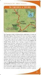
L’It<strong>in</strong>erario delle forre etrusche e del<strong>la</strong> valle del Tevere<br />
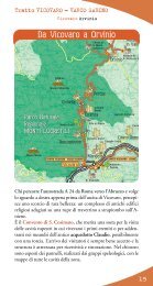
Dal<strong>la</strong> via Cassia a Calcata<br />
Il nostro it<strong>in</strong>erario prende le mosse dal<strong>la</strong> località Settevene,<br />
lungo <strong>la</strong> via Cassia, <strong>in</strong> prossimità del piccolo <strong>la</strong>go di Monterosi.<br />
E’ un <strong>la</strong>go di ridotte dimensioni, appena 0,33 chilometri quadrati<br />
di superficie, con un diametro di seicento metri, un perimetro<br />
di tre chilometri circa e una profondità media <strong>in</strong>torno ai sette<br />
metri. N<strong>in</strong>fee bianche e altre piante acquatiche ne fanno un<br />
ambiente assai gradevole, oltre tutto frequentato da una comunità<br />
di uccelli che comprende tarabus<strong>in</strong>i, garzette, mart<strong>in</strong> pescatori<br />
e, tra gli anfibi, il tritone crestato. Siamo nel territorio comunale<br />
di Nepi, <strong>in</strong> prov<strong>in</strong>cia di Viterbo. Sul<strong>la</strong> conso<strong>la</strong>re, qui a doppia<br />
corsia, occorre fare attenzione e svoltare a destra seguendo le<br />
<strong>in</strong>dicazioni per Mazzano Romano, Calcata, Faleria. E subito il<br />
paesaggio cambia, facendosi più solitario e <strong>la</strong>sciandosi f<strong>in</strong>almente<br />
alle spalle l’affol<strong>la</strong>to orizzonte che caratterizza l’area metropolitana.<br />
Quello <strong>in</strong> cui facciamo <strong>in</strong>gresso è il Lazio etrusco, dove antichi<br />
apparati vulcanici hanno ricoperto con le loro effusioni le rocce<br />
e i terreni più antichi. Ed è lo scorrere delle acque di superficie,<br />
assieme agli agenti atmosferici, ad aver scavato negli strati<br />
13
14<br />
L’It<strong>in</strong>erario delle forre etrusche e del<strong>la</strong> valle del Tevere<br />
Via Cassia Calcata<br />
vulcanici f<strong>in</strong>o a disegnare i paesaggi che ci scorrono adesso dietro<br />
ai vetri dell’auto. Proprio dalle sponde di un corso d’acqua ha<br />
<strong>in</strong>izio il nostro lungo percorso: il Treja.<br />
Il fiume Treja<br />
Il bac<strong>in</strong>o del fiume Treja si estende per circa 490 chilometri<br />
quadrati nel settore nord-orientale del complesso vulcanico<br />
sabat<strong>in</strong>o. Il corso d’acqua si orig<strong>in</strong>a a nord-est del <strong>la</strong>go di<br />
Bracciano e scorre dapprima <strong>in</strong> direzione sudovest-nordest<br />
e qu<strong>in</strong>di <strong>in</strong> direzione nord-sud: quest’ultima è anche <strong>la</strong><br />
direzione di scorrimento del<strong>la</strong> maggior parte degli affluenti<br />
ed <strong>in</strong> partico<strong>la</strong>re di quelli che drenano il versante destro. Tutti<br />
i corsi d’acqua presenti nel bac<strong>in</strong>o presentano regime torrentizio,<br />
e risentono qu<strong>in</strong>di del<strong>la</strong> distribuzione delle precipitazioni<br />
nell’arco dell’anno. Il valore medio annuo raggiunto dalle<br />
piogge raggiunge nell’area i 1011 millimetri, con picchi<br />
naturalmente nelle stagioni autunnale e <strong>in</strong>vernale e, <strong>in</strong><br />
partico<strong>la</strong>re, nel mese di novembre (150 millimetri circa).<br />
Successivamente le precipitazioni tendono a dim<strong>in</strong>uire <strong>in</strong><br />
primavera e si fanno rare <strong>in</strong> estate, con un m<strong>in</strong>imo di circa<br />
24 millimetri <strong>in</strong> luglio.<br />
Del<strong>la</strong> fitta vegetazione che <strong>in</strong>teressa il territorio del<strong>la</strong> valle<br />
fluviale va sottol<strong>in</strong>eato un aspetto peculiare, e cioè quel<strong>la</strong> che<br />
i botanici chiamano <strong>in</strong>versione del<strong>la</strong> successione vegetazionale.<br />
In poche parole, a causa del<strong>la</strong> marcata umidità causata dal<br />
torrente e dalle conseguenti temperature più basse, nel<br />
fondovalle crescono specie normalmente presenti a quote<br />
maggiori quali il faggio: viceversa, più <strong>in</strong> alto è possibile
L’It<strong>in</strong>erario delle forre etrusche e del<strong>la</strong> valle del Tevere<br />
Via Cassia Calcata<br />
<strong>in</strong>contrare ad esempio specie del<strong>la</strong> macchia mediterranea o<br />
alberi come il leccio, tipicamente presenti nelle aree più<br />
soleggiate ed asciutte.<br />
Quanto agli aspetti faunistici e più <strong>in</strong> generale ecologici, è<br />
da notare come <strong>in</strong> un ambiente naturale così delicato quale<br />
una picco<strong>la</strong> valle fluviale <strong>in</strong>terventi umani anche non vistosi<br />
si traducano <strong>in</strong> brusche variazioni del popo<strong>la</strong>mento animale<br />
e vegetale. Così, per fare un esempio, <strong>la</strong> mancata depurazione<br />
degli scarichi civili <strong>dei</strong> centri abitati limitrofi al fiume protrattasi<br />
a lungo ha causato <strong>la</strong> recente scomparsa di alcune speciesimbolo<br />
di questi habitat, come il merlo acquaiolo.<br />
Nel 2006 con il coord<strong>in</strong>amento e <strong>la</strong> partecipazione attiva del<br />
parco tutti gli otto Comuni <strong>in</strong>teressati (Calcata, Castel S. Elia,<br />
Civita Castel<strong>la</strong>na, Magliano Romano, Mazzano Romano,<br />
Monterosi, Nepi e Faleria) è stata sottoscritta una<br />
“Convenzione per il Recupero e <strong>la</strong> Valorizzazione del Territorio<br />
del Bac<strong>in</strong>o del Treja”.<br />
Il progetto prevede azioni di recupero e valorizzazione del<strong>la</strong><br />
rete storico-sentieristica, <strong>dei</strong> siti archeologici, del<strong>la</strong> rete<br />
idrografica, degli antichi castelli ed abbazie, delle sorgenti e<br />
delle mole.<br />
The Treja River<br />
The Treja River bas<strong>in</strong> covers over 490 square kilometers <strong>in</strong> the north-east<br />
sector of the Sabat<strong>in</strong>i volcanic complex. An <strong>in</strong>terest<strong>in</strong>g phenomenon occurs<br />
<strong>in</strong> the thick vegetation surround<strong>in</strong>g the river valley. This is what botanists call<br />
reverse p<strong>la</strong>nt succession. This occurs due to the marked humidity caused by the<br />
stream and the consequent lower temperatures.<br />
Therefore, species normally present at higher elevations such as beech grow at<br />
the bottom of the valley whereas as the elevation <strong>in</strong>creases you f<strong>in</strong>d p<strong>la</strong>nts<br />
common to the Mediterranean scrub or trees such as the holm-oak which are<br />
typically found <strong>in</strong> sunnier drier areas.<br />
As for the fauna and overall ecology, one must note how <strong>in</strong> such a delicate<br />
natural area as a small river valley, even small actions taken by man that do<br />
not seem visible trans<strong>la</strong>te <strong>in</strong>to brusque variations <strong>in</strong> p<strong>la</strong>nt and animal popu<strong>la</strong>tions.<br />
Therefore, as an example, the untreated sewage water from towns surround<strong>in</strong>g<br />
the river over time caused the recent disappearance of species symbolic to these<br />
habitats such as the white-throated dipper (also known as the European dipper).<br />
In 2006 under the guid<strong>in</strong>g <strong>in</strong>fluence of the park authorities an agreement was<br />
made among all eight municipalities connected with the river valley.<br />
The result<strong>in</strong>g document is called Convenzione per Il Recupero e <strong>la</strong> Valorizzazione<br />
del Territorio del Bac<strong>in</strong>o del Treja” which is an agreement for the recovery<br />
and promotion of the Treja River Bas<strong>in</strong> area.<br />
15
16<br />
L’It<strong>in</strong>erario delle forre etrusche e del<strong>la</strong> valle del Tevere<br />
Via Cassia Calcata<br />
Cascate di Monte Ge<strong>la</strong>to<br />
Dopo alcuni chilometri di strada si arriva al bivio per Monte<br />
Ge<strong>la</strong>to, segna<strong>la</strong>to non solo da uno ma da una concentrazione<br />
di cartelli e tabelle pubblicitarie che deve far riflettere<br />
sull’<strong>in</strong>qu<strong>in</strong>amento paesaggistico causato da questa forma di<br />
comunicazione, se non rego<strong>la</strong>ta dal rispetto delle leggi e dal<br />
buon senso. Siamo nell’area probabilmente più nota e visitata<br />
del parco del<strong>la</strong> Valle del Treja, per il resto uno <strong>dei</strong> più appartati<br />
e poco conosciuti del Lazio, ed il motivo sta nel fasc<strong>in</strong>o semplice<br />
ma <strong>in</strong>negabile delle piccole cascate che il Treja forma <strong>in</strong> prossimità<br />
di una antica Mo<strong>la</strong>.<br />
Questo è il settore sud-occidentale dell’area protetta – oltre 620<br />
ettari di superficie, nei Comuni di Mazzano Romano e Calcata,<br />
istituita dal<strong>la</strong> Regione Lazio - che si estende ad est del<strong>la</strong> prov<strong>in</strong>ciale<br />
su entrambi le sponde del corso d’acqua. L’area vanta una<br />
lunghissima frequentazione da parte dell’uomo, probabilmente<br />
già <strong>in</strong> epoca preistorica. Qui venne edificata una vil<strong>la</strong> <strong>in</strong> età<br />
romana, forse una lussuosa residenza di campagna ai tempi di<br />
Augusto, <strong>in</strong> seguito affiancata da un mausoleo; e qu<strong>in</strong>di una<br />
chiesa, attorno a cui sorse un borgo afferente nell’VIII secolo<br />
all’azienda agrico<strong>la</strong> papale denom<strong>in</strong>ata Capracorum. Il mul<strong>in</strong>o<br />
ad acqua viene edificato per ultimo, nel 1831, quando gli abitanti<br />
del borgo si erano trasferiti negli abitati meglio difendibili sulle<br />
alture ed il Treja era tornato solitario.<br />
Restaurata da qualche anno come <strong>la</strong> vic<strong>in</strong>a torretta d’avvistamento,<br />
<strong>la</strong> mo<strong>la</strong> oggi ospita al pian terreno <strong>la</strong> mac<strong>in</strong>a collegata al<strong>la</strong> ruota,<br />
<strong>in</strong> parte ricostruita. Al primo piano c’è un’esposizione storica
L’It<strong>in</strong>erario delle forre etrusche e del<strong>la</strong> valle del Tevere<br />
Via Cassia Calcata<br />
e archeologica sul luogo; al secondo piano vi sono alcuni pannelli<br />
che spiegano cos’è <strong>la</strong> biodiversità, con un apiario dimostrativo<br />
a scopo didattico. D’età medievale e qu<strong>in</strong>di antecedente, <strong>la</strong><br />
torretta era <strong>in</strong> orig<strong>in</strong>e più alta e ricoperta da un tetto <strong>in</strong> scandole<br />
di pietra.<br />
Una volta giunti a Mazzano Romano, pochi chilometri più a<br />
ovest, si deve scendere per andare a visitare il centro storico<br />
seguendo le <strong>in</strong>dicazioni per gli uffici del parco. In fondo al<strong>la</strong><br />
discesa c’è <strong>la</strong> m<strong>in</strong>usco<strong>la</strong> piazzetta Umberto I da cui si prosegue<br />
a piedi f<strong>in</strong>o al<strong>la</strong> Mo<strong>la</strong> Vecchia <strong>in</strong> riva al Treja oppure a s<strong>in</strong>istra,<br />
dopo un bell’arco, verso i vicoli del centro e pure gli uffici del<br />
parco. Da vedere <strong>in</strong> partico<strong>la</strong>re ci sono il pa<strong>la</strong>zzo baronale <strong>dei</strong><br />
Biscia e <strong>la</strong> piazza Antisà, con quel che resta (una parte del coro)<br />
del<strong>la</strong> c<strong>in</strong>quecentesca chiesa di San Nico<strong>la</strong> attribuita al Vigno<strong>la</strong><br />
e abbattuta nel 1940 perché perico<strong>la</strong>nte.<br />
Dal nome derivante da un fondo di nome Matianum, appartenuto<br />
a una nobile famiglia romana, il paese affonda le sue orig<strong>in</strong>i<br />
nel<strong>la</strong> storia degli antichi <strong>in</strong>sediamenti falisci, del<strong>la</strong> cui presenza<br />
rimangono diverse necropoli nel territorio da cui scavi archeologici<br />
hanno tratto importanti reperti perlopiù esposti nel museo<br />
nazionale dell’Agro Falisco a Civita Castel<strong>la</strong>na e nel museo<br />
nazionale etrusco di Vil<strong>la</strong> Giulia a Roma. Tornato alle cronache<br />
poco prima dell’anno Mille, Mazzano appartenne tra gli altri<br />
agli Anguil<strong>la</strong>ra e qu<strong>in</strong>di ai Del Drago, che lo amm<strong>in</strong>istrarono<br />
f<strong>in</strong>o al<strong>la</strong> riforma fondiaria dell’Ente Maremma.<br />
Vicolo del centro storico di Mazzano Romano<br />
17
18<br />
L’It<strong>in</strong>erario delle forre etrusche e del<strong>la</strong> valle del Tevere<br />
Via Cassia Calcata<br />
Ripresa <strong>la</strong> prov<strong>in</strong>ciale <strong>in</strong> direzione Calcata, prima del ponte sul<br />
Treja – dove cade il conf<strong>in</strong>e tra le prov<strong>in</strong>ce di Roma e di Viterbo<br />
– e di una salita una strada bianca parte a destra sotto <strong>la</strong> freccia<br />
“Scavo archeologico”. Subito, alzando lo sguardo a s<strong>in</strong>istra, si<br />
nota <strong>la</strong> parete terrosa stratificata messa a nudo dal taglio del<br />
pendio, dove gli alberi affondano le radici tra piccoli ciottoli<br />
chiari. Siamo davanti a un luogo con partico<strong>la</strong>re valenza dal<br />
punto di vista geologico. Infatti quelle pietre di natura calcarea<br />
sono state depositate da un corso d’acqua che ora non c’è più,<br />
che i ricercatori hanno chiamato Paleotevere ad <strong>in</strong>dicare il<br />
grande fiume che <strong>in</strong> epoca remota aveva un percorso differente<br />
da quello attuale ben più ad est. Proseguendo <strong>la</strong> strad<strong>in</strong>a bianca<br />
si sbuca ai marg<strong>in</strong>i di una radura, <strong>in</strong> parte occupata dalle strutture<br />
di copertura di un’area archeologica. Si tratta <strong>dei</strong> resti di un<br />
tempio al<strong>la</strong> base di Monte Li Santi, l’altura che si trova sul<strong>la</strong><br />
s<strong>in</strong>istra, parte del sistema <strong>in</strong>sediativo del<strong>la</strong> città falisca di Narce.<br />
Dal tempio, coperto da una tettoia - gli scavi sono attualmente<br />
fermi – voltandosi verso Calcata si vede <strong>la</strong> coll<strong>in</strong>a tondeggiante<br />
e ricoperta di bosco dove sorgeva l’antico centro italico. F<strong>in</strong>o a<br />
qualche decennio fa, quando i tagli erano ben più frequenti e<br />
questi rilievi non erano così ammantati di alberi, si scorgevano<br />
bene anche le pareti di tufo sottostanti. Su Narce le notizie<br />
storiche sono poche e gli archeologi, <strong>in</strong> attesa di studi più<br />
conv<strong>in</strong>centi, avanzano ipotesi. Pare che fosse il pr<strong>in</strong>cipale centro<br />
dell’agro falisco meridionale e che fosse strettamente collegato<br />
all’etrusca e vic<strong>in</strong>a Veio. Pare anche che l’altura di Narce propriamente<br />
detta fosse <strong>in</strong> realtà l’acropoli di una città assai<br />
più estesa, circondata da necropoli. Forse il suo nome<br />
era Fescennium, citato da fonti letterarie di età<br />
romana. Monte Li Santi e Pizzopiede sono<br />
i nomi delle altre alture che formavano l’antico<br />
centro abitato, un tempo separate<br />
solo dalle forre ed<br />
attualmente anche<br />
dal<strong>la</strong> strada prov<strong>in</strong>ciale.Sull’acropoli<br />
di Pizzopiede,<br />
ancora oggi, tra i<br />
prati s’<strong>in</strong>contrano<br />
resti di mura appartenuteall’<strong>in</strong>sediamento.
L’It<strong>in</strong>erario delle forre etrusche e del<strong>la</strong> valle del Tevere<br />
Via Cassia Calcata<br />
Borgo di Calcata<br />
Tornati sui propri passi f<strong>in</strong>o al bivio con <strong>la</strong> prov<strong>in</strong>ciale, si prosegue<br />
<strong>in</strong> direzione Calcata. E il paes<strong>in</strong>o appare presto, appol<strong>la</strong>iato su<br />
un acrocoro roccioso che dom<strong>in</strong>a <strong>la</strong> val<strong>la</strong>ta completamente<br />
rivestita di bosco. Nel centro storico senz’auto si accede oltre<br />
una doppia porta ad arco, sovrastata dalle mura mer<strong>la</strong>te del<br />
pa<strong>la</strong>zzo baronale Anguil<strong>la</strong>ra. Dal<strong>la</strong> piazza, dov’è <strong>la</strong> chiesa<br />
parrocchiale, partono strad<strong>in</strong>e e vicoli dove sono alcuni negozi di<br />
artigiani, generalmente persone trasferitesi qui da altre zone d’Italia<br />
quando non addirittura dall’estero. E poi cortili, rampe dove<br />
siedono gatti, terrazzi affacciati sul<strong>la</strong> val<strong>la</strong>ta e immersi nel silenzio:<br />
Calcata è tutta qui, davvero apparentemente fuori dal tempo. Dal<br />
borgo sono possibili numerose escursioni. D’<strong>in</strong>teresse naturalistico<br />
e culturale quel<strong>la</strong> che ha come meta il castello di Fogliano, o<br />
meglio i suoi ruderi, a nord-est dell’abitato.<br />
Da Calcata si segue <strong>la</strong> strada che porta a Faleria e <strong>in</strong> località<br />
Montorso si prende a s<strong>in</strong>istra per un’ampia sterrata. Parcheggiata<br />
l’auto, si prosegue a piedi tra macchie di ceduo e radure tenendosi<br />
sul<strong>la</strong> destra ed entrando nel fitto bosco di cerri, roverelle e farnie.<br />
Più a valle, <strong>in</strong>vece, alle querce si sostituiranno i salici, gli alti<br />
pioppi, gli ornielli A circa un’ora e un quarto dal<strong>la</strong> partenza si<br />
giunge <strong>in</strong> vista di una picco<strong>la</strong> altura, sul<strong>la</strong> sommità del<strong>la</strong> quale<br />
sorgono le rov<strong>in</strong>e. Non rimane molto dell’antico maniero: giusto<br />
una torre, alcune grotte sottostanti, brandelli di mura perimetrali<br />
e, soprattutto, una splendida posizione panoramica. Un tempo<br />
presidio prezioso per sorvegliare buona parte del<strong>la</strong> val<strong>la</strong>ta, il<br />
castello è <strong>in</strong>fatti un balcone naturale sulle gole del fiume.<br />
19
20<br />
L’It<strong>in</strong>erario delle forre etrusche e del<strong>la</strong> valle del Tevere<br />
Via Cassia Calcata<br />
Appartenuto agli Anguil<strong>la</strong>ra, ai Frangipane e qu<strong>in</strong>di nuovamente<br />
agli Anguil<strong>la</strong>ra, s’ipotizza che sorga su un precedente <strong>in</strong>sediamento<br />
etrusco. Non lontano dai ruderi del castello di Fogliano sorgono<br />
altre rov<strong>in</strong>e, quelle di Castel Paterno. Menzionato nei documenti<br />
storici come Paternum, è uno <strong>dei</strong> castelli più illustri a nord di<br />
Roma poiché nel gennaio del 1002 ospitò amma<strong>la</strong>to e morente<br />
nientemeno che l’imperatore Ottone III. Oggi quel che ne resta<br />
– il maniero già nel C<strong>in</strong>quecento viene descritto <strong>in</strong> rov<strong>in</strong>a –<br />
occupa l’estremità di un’altura stretta fra due fossi, quello del<strong>la</strong><br />
Mo<strong>la</strong> e quello di Stabia, al<strong>la</strong> loro confluenza nel Treja.<br />
Tornati <strong>in</strong>dietro al<strong>la</strong> base dell’altura, si prende a seguire una traccia<br />
che scende ripida e poco evidente sul<strong>la</strong> destra, aggira <strong>la</strong> rupe tufacea<br />
del castello e cont<strong>in</strong>ua nel magnifico bosco. Deviando ancora a<br />
destra si arriva sulle sponde del torrente e lo si segue sul<strong>la</strong> s<strong>in</strong>istra.<br />
Lungo le rive sassose, qui, nell’ombroso e umido tunnel del<strong>la</strong> forra<br />
s’<strong>in</strong>contrano felci dalle fronde strepitose, l<strong>in</strong>gue cerv<strong>in</strong>e lunghe un<br />
braccio: e poi primule, polmonarie e bucaneve a seconda del<strong>la</strong><br />
stagione. Anche per <strong>la</strong> fauna, l’elenco è lungo e importante ma<br />
certo non verificabile <strong>in</strong> una s<strong>in</strong>go<strong>la</strong> gita: le martore, le istrici, i gufi,<br />
il raro gatto selvatico e pers<strong>in</strong>o <strong>la</strong> <strong>la</strong>mpreda, un pesce privo di<br />
mascel<strong>la</strong> autentico “fossile vivente”, è <strong>in</strong>utile prometterli a chi non<br />
è più che fortunato. Ma ci si può rifare con lo sparviero, <strong>la</strong> poiana,<br />
<strong>la</strong> donno<strong>la</strong> e <strong>la</strong> natrice dal col<strong>la</strong>re, che non di rado si vede attraversare<br />
il corso d’acqua a caccia di anfibi. Va segna<strong>la</strong>to che l’elevato valore<br />
naturalistico di questi luoghi, naturalmente, non si esaurisce entro<br />
i conf<strong>in</strong>i del parco (di cui qui ci troviamo all’estremità settentrionale).<br />
Non a caso, poco a nord-ovest dell’area protetta si trova il sito<br />
d’<strong>in</strong>teresse comunitario (Sic) Fosse Cerreto, che si estende su 330<br />
ettari lungo le sponde dell’omonimo corso d’acqua. Si tratta di un<br />
vallone tufaceo con ambienti rupestri e fluviali di partico<strong>la</strong>re<br />
importanza per l’avifauna e per l’ittiofauna: vi sono stati censiti<br />
come presenti, <strong>in</strong>fatti, rapaci come il biancone o il lodo<strong>la</strong>io e pesci<br />
quali il ghiozzo di ruscello e il vairone. Specie di grande importanza,<br />
soprattutto queste ultime vista <strong>la</strong> situazione sempre più critica <strong>in</strong><br />
cui versano i pesci d’acqua dolce nel nostro Paese. Non è più<br />
nidificante, <strong>in</strong>vece, il maestoso gufo reale che nei decenni passati<br />
si riproduceva <strong>in</strong> queste forre, come testimoniato anche da Fulco<br />
Pratesi che lo citava nel<strong>la</strong> sua ormai storica Guida al<strong>la</strong> natura del<br />
Lazio e Abruzzo scritta assieme a Franco Tassi nel 1972. Cont<strong>in</strong>uando<br />
a camm<strong>in</strong>are ad occhi aperti, dunque, si entra più avanti nelle gole<br />
del Treja vere e proprie, strette dal bosco e dalle gialle rocce a<br />
strapiombo. Poi il paesaggio si apre, il sentiero prosegue tra i campi<br />
coltivati e si arrampica f<strong>in</strong>o alle case arroccate di Calcata.
It<strong>in</strong>erary of the Etruscan canyons and the Tiber Valley<br />
From via Cassia to Calcata<br />
Our it<strong>in</strong>erary starts off at Settevene, along the Via Cassia near the small Monterosi<br />
Lake. This consu<strong>la</strong>r road now has two <strong>la</strong>nes go<strong>in</strong>g <strong>in</strong> each direction. Pay attention<br />
to the road signs and turn right follow<strong>in</strong>g the signs for Mazzano Romano, Calcata,<br />
Faleria. The <strong>la</strong>ndscape changes immediately and becomes more solitary. The<br />
crowded horizon of the metropolitan area is f<strong>in</strong>ally left beh<strong>in</strong>d. After driv<strong>in</strong>g for<br />
a few kilometers you will reach the <strong>in</strong>tersection for Monte Ge<strong>la</strong>to. This <strong>in</strong>tersection<br />
is marked not just by one sign but by a whole group of signs and billboards which<br />
should make us reflect on “<strong>la</strong>ndscape pollution” caused by this type of communication<br />
if <strong>la</strong>ws and good sense are not respected. We are now <strong>in</strong> the area which is probably<br />
the best-known and most visited part of the Valle del Treja park, one of the most<br />
iso<strong>la</strong>ted and little-known parks of Lazio.The reason for this is the simple but<br />
undeniable fasc<strong>in</strong>ation of the small waterfalls that the Treja River forms near<br />
an ancient mill (Mo<strong>la</strong>).<br />
This is the south-west sector of the protected area established by the Lazio Region<br />
which extends to the east of the prov<strong>in</strong>cial road on both sides of the river. It covers<br />
more than 620 hectares of <strong>la</strong>nd <strong>in</strong> the municipalities of Mazzano Romano and<br />
Calcata. The Mill was restored a few years ago as was the nearby watch tower.<br />
Today on the ground floor of the mill there is a stone mill connected to a wheel,<br />
which has been partially rebuilt. On the first floor there is an exhibition about<br />
the history and archeology of the area. On the second floor there are some panels<br />
that exp<strong>la</strong><strong>in</strong> about its biodiversity as well as an educational apiary. The watch<br />
tower is medieval and therefore built prior to the mill. It orig<strong>in</strong>ally stood higher<br />
and was covered by a stone sh<strong>in</strong>gle roof.<br />
21
22<br />
It<strong>in</strong>erary of the Etruscan canyons and the Tiber Valley<br />
Once you reach Mazzano Romano, a few kilometers further to the west, drive<br />
downhill follow<strong>in</strong>g the signs for the park offices to visit the historic town center.<br />
At the bottom of the descent there is the t<strong>in</strong>y Piazza Umberto I from where you<br />
can walk to the Mo<strong>la</strong> Vecchia (the Old Mill) on the bank of the Treja River or<br />
if you turn left from the piazza after you pass a lovely arch, you can walk along<br />
the small streets of the center toward the offices of the park.<br />
The baronial pa<strong>la</strong>ce of the Biscia family and the Antisà piazza are worth see<strong>in</strong>g.<br />
In the square there are the rema<strong>in</strong>s (a part of the choir) of the fifteenth century<br />
San Nico<strong>la</strong> church attributed to Vigno<strong>la</strong> and demolished <strong>in</strong> 1940 because of safety<br />
concerns. Get back onto the prov<strong>in</strong>cial road and head towards Calcata. Before<br />
you reach the bridge over the Treja River – which is the boundary between the<br />
prov<strong>in</strong>ces of Rome and Viterbo – and before the road climbs, take the gravel road<br />
on the right follow<strong>in</strong>g the arrow <strong>in</strong>dicat<strong>in</strong>g “Scavo archeologico” (excavations).<br />
Look<strong>in</strong>g up immediately to the left, you can see a stratified earthen wall which<br />
was bared when the slope was cut. Here you can see tree roots mak<strong>in</strong>g their way<br />
among the small pale pebbles. We are <strong>in</strong> front of a geosite, i.e. a p<strong>la</strong>ce with special<br />
geological importance. In fact, these calcareous rocks were deposited by a waterway<br />
that no longer exists. Researchers th<strong>in</strong>k that the Tiber River, which today lies<br />
much further to the east, had <strong>in</strong> a remote era flowed <strong>in</strong> this area. Therefore they<br />
called this primeval waterway “Paleotevere”.<br />
Follow<strong>in</strong>g a gravel road we come upon a clear<strong>in</strong>g partially occupied by the roofed<br />
structures of an archeological area. These are the rema<strong>in</strong>s of a temple located at<br />
the foot of Monte Li Santi, the hill that is found on the left. It was part of the<br />
urban structure of the Faliscan city of Narce. At the moment archaeological<br />
activity is suspended. From the roof-covered temple turn towards Calcata and you<br />
can see a rounded hill covered by woods where the ancient Italic center stood. Go<br />
back to the <strong>in</strong>tersection with the prov<strong>in</strong>cial road and head towards Calcata. The<br />
little town soon appears. It is perched on a rocky p<strong>la</strong>teau which dom<strong>in</strong>ates the<br />
valley completely covered by woods. The historic town center is closed to traffic<br />
and you can enter it through an arched double gateway surmounted by the<br />
crenel<strong>la</strong>ted walls of the baronial Pa<strong>la</strong>zzo Anguil<strong>la</strong>ra. The square where there<br />
is the parish church opens onto small streets and alleys l<strong>in</strong>ed with artisans’ shops.<br />
These craftsmen usually come from other parts of Italy and <strong>in</strong> some cases from<br />
foreign countries. You can also see courtyards, cats sitt<strong>in</strong>g on ramps and w<strong>in</strong>dow<br />
sills, terraces look<strong>in</strong>g over the valley and you are immersed <strong>in</strong> silence. This is<br />
Calcata, where time seems to stand still.<br />
Several excursions are possible from the town. An <strong>in</strong>terest<strong>in</strong>g excursion through<br />
nature and history is the one to the Fogliano castle, or rather we should say its<br />
ru<strong>in</strong>s, which are located north-east of the town. From Calcata follow the road<br />
that goes to Faleria and <strong>in</strong> the Montorso locality turn left onto a wide dirt road.<br />
Park the car and go on foot among the coppice wood<strong>la</strong>nds and meadows keep<strong>in</strong>g<br />
to the right and enter<strong>in</strong>g the thick woods. After about an hour and a half you will<br />
reach a small rise with the ru<strong>in</strong>s of a tower on its peak, some subterranean rooms<br />
below, and the rema<strong>in</strong>s of perimetral walls. Not far from the Fogliano castle there<br />
are the ru<strong>in</strong>s of Castel Paterno where the ill and dy<strong>in</strong>g Emperor Otto III was a<br />
guest. He died here <strong>in</strong> January 1002.
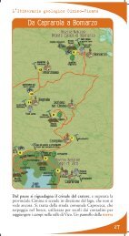
Il parco naturale regionale<br />
del<strong>la</strong> Valle del Treja<br />
I<br />
l Treja è un modesto corso d’acqua che<br />
sorge dai monti Sabat<strong>in</strong>i per confluire<br />
nel Tevere all’altezza di Civita Castel<strong>la</strong>na.<br />
Sono circa 30 km di percorso nei quali attraversa<br />
una campagna <strong>in</strong> buona parte coltivata, ma le acque<br />
nel tempo hanno creato un mondo ancora selvatico:<br />
è quello delle forre, scavate nei teneri tufi dell’antico<br />
vulcano sabat<strong>in</strong>o. Istituita nel 1982, l’area protetta si estende su<br />
628 ettari nel territorio <strong>dei</strong> Comuni di Calcata e Mazzano<br />
Romano.<br />
E’ quello <strong>dei</strong> boschi l’ambiente più rappresentato, un nastro<br />
verde che seguendo il corso d’acqua serpeggia nel<strong>la</strong> campagna<br />
circostante. I conf<strong>in</strong>i del parco comprendono generalmente le<br />
fasce ripariali f<strong>in</strong>o a poche cent<strong>in</strong>aia di metri di profondità verso<br />
l’<strong>in</strong>terno, prendendo più respiro nel settore centrale ad abbracciare<br />
le alture di Pizzopiede e di Monte Li Santi appena a sud di<br />
Calcata. Qui confluiscono nel Treja<br />
due torrenti, il fosso del<strong>la</strong> Mo<strong>la</strong> e il<br />
fosso del<strong>la</strong> Selva, che scorrono talvolta<br />
tra gole dalle<br />
pareti verticali.<br />
I centri storici<br />
<strong>dei</strong> due paesi<br />
sono le prime<br />
emergenze<br />
storico-artistiche<br />
del parco. La<br />
fama di Calcata<br />
va ben oltre<br />
l’ambito locale, e<br />
non a caso è<br />
scelta spesso da<br />
registi e sceneggiatori
per ambientare riprese c<strong>in</strong>ematografiche e televisive. Anche <strong>la</strong><br />
parte antica di Mazzano Romano mantiene l’impronta urbana<br />
medievale, con un’unica via che percorre ad anello l’addossarsi<br />
di abitazioni tra cui s’<strong>in</strong>tersecano i vicoli e le rampe.<br />
Ma il territorio del parco riveste notevole importanza anche per<br />
le testimonianze archeologiche.<br />
Numerose sono le necropoli r<strong>in</strong>venute e <strong>in</strong> partico<strong>la</strong>re quelle<br />
attribuite all’antico centro di Narce, tra le capitali dell’agro<br />
falisco e cioè di quell’area occupata dall’antico popolo italico<br />
<strong>dei</strong> Falisci che par<strong>la</strong>va un dialetto <strong>la</strong>t<strong>in</strong>o e che si schierò al fianco<br />
degli etruschi contro le prime mire espansionistiche <strong>dei</strong> romani.<br />
Quanto al<strong>la</strong> biodiversità, flora e fauna presenti pure sono di<br />
tutto rispetto e annoverano specie anche rare, che trovano rifugio<br />
e tranquillità negli ambienti del parco.<br />
Di istrici, tassi e naturalmente c<strong>in</strong>ghiali e volpi non è raro<br />
r<strong>in</strong>venire le tracce. Rapaci caratteristici degli ambienti boschivi<br />
come il nibbio bruno, <strong>la</strong> poiana, il falco pecchiaiolo si<br />
affiancano ad altri ad abitud<strong>in</strong>i rupicole, quali il gheppio ed<br />
il raro <strong>la</strong>nario. Sa<strong>la</strong>mandr<strong>in</strong>e dagli occhiali, testugg<strong>in</strong>i d’acqua,<br />
rane dalmat<strong>in</strong>e sono tra i protagonisti dell’erpetofauna, mentre<br />
le acque del Treja ospitano tra gli altri il barbo, il vairone, il<br />
ghiozzo di ruscello.<br />
Valle del Treja nature park<br />
The Treja River, a tributary of the Tiber River, rises from the Monti Sabat<strong>in</strong>i.<br />
Along its course a regional park was established <strong>in</strong> 1982 which extends for 628<br />
hectares. The boundaries of the park <strong>in</strong>clude the areas along both river banks up<br />
to a few hundred meters <strong>in</strong><strong>la</strong>nd and then widen <strong>in</strong> its central area where the hills<br />
of Pizzopiede and Monte Li Santi, just south of Calcata, are <strong>in</strong>cluded. At this<br />
po<strong>in</strong>t two streams flow <strong>in</strong>to the Treja River, the Mo<strong>la</strong> and the Selva, which at<br />
times flow between the gorges with their vertical walls. The historic centers of<br />
Calcata and Mazzano are the ma<strong>in</strong> historical-artistic attractions of the park.<br />
They both date back to the Middle Ages and are splendidly <strong>in</strong>tegrated <strong>in</strong>to the<br />
<strong>la</strong>ndscape. Several necropolises have been found. The most important one is thought<br />
to be re<strong>la</strong>ted to the ancient Faliscan center of Narce. Flora and fauna are abundant<br />
<strong>in</strong> the heavily wooded area of the park. It is not uncommon to come upon traces<br />
of porcup<strong>in</strong>es, badgers, and more often of boars and foxes.<br />
Birds of prey common to wooded areas such as b<strong>la</strong>ck kite, common buzzards,<br />
honey buzzards live side by side with other birds of prey that live <strong>in</strong> rocky areas<br />
such as the common kestrel and the rare <strong>la</strong>nner falcon. Amphibians and reptiles<br />
<strong>in</strong>clude the spectacled sa<strong>la</strong>mander, water turtles, and agile frogs whereas the waters<br />
are home to barbel, telestes, and the Italian freshwater goby.
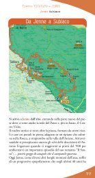
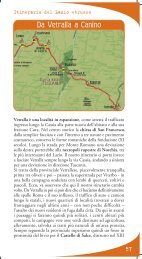
L’It<strong>in</strong>erario delle forre etrusche e del<strong>la</strong> valle del Tevere<br />
Da Calcata a Sant’Oreste<br />
Ripresa <strong>la</strong> prov<strong>in</strong>ciale e superato il bivio per Magliano Romano,<br />
si è presto a Faleria. Su uno sperone roccioso alto sul Treja e<br />
sul fosso del<strong>la</strong> Mo<strong>la</strong>, il suo centro storico color tufo venne <strong>in</strong><br />
gran parte abbandonato <strong>in</strong> seguito ad un terremoto nel 1942<br />
ed evacuato nei primi anni Settanta. Esistono piani di recupero,<br />
ancora <strong>in</strong>attuati. In età romana Faleria si chiamava Stab<strong>la</strong>, per<br />
via del<strong>la</strong> vic<strong>in</strong>a statio (stazione di posta) di Stabulum sul<strong>la</strong> via<br />
F<strong>la</strong>m<strong>in</strong>ia. Il paese conobbe il suo apogeo nel C<strong>in</strong>quecento<br />
quando venne <strong>in</strong>grandito il castello degli Anguil<strong>la</strong>ra, <strong>dei</strong> cui<br />
beni Faleria era entrata a far parte nel XIV secolo. A quell’epoca<br />
risale pure <strong>la</strong> costruzione delle mura con torri e porte, superate<br />
nell’Ottocento dall’ampliamento del borgo e quasi del tutto<br />
distrutte a <strong>in</strong>izio Novecento. Da visitare c’è soprattutto <strong>la</strong> chiesa<br />
di San Giuliano, dedicata al patrono San Giuliano Ospitaliere,<br />
con pianta basilicale a tre navate. Nel C<strong>in</strong>quecento vi fu affiancato<br />
il campanile, alleggerito da bifore.<br />
A Faleria si prende <strong>la</strong> via Roma <strong>in</strong> salita, <strong>in</strong> direzione Rignano.<br />
Si tratta del<strong>la</strong> strada prov<strong>in</strong>ciale Falisca che, stretta, sale nel<strong>la</strong><br />
campagna tra fi<strong>la</strong>ri di belle querce. Passata <strong>la</strong> chiesetta del<strong>la</strong><br />
Madonna del Giglio, e più avanti un passaggio a livello, si entra<br />
<strong>in</strong> Rignano F<strong>la</strong>m<strong>in</strong>io. Ai marg<strong>in</strong>i del borgo d’orig<strong>in</strong>e medievale<br />
25
26<br />
L’It<strong>in</strong>erario delle forre etrusche e del<strong>la</strong> valle del Tevere<br />
Calcata Sant’Oreste<br />
Faleria<br />
- di fronte a una torre quadrata duecentesca, appartenuta a un<br />
castello di proprietà <strong>dei</strong> Savelli - sorge <strong>la</strong> parrocchiale, <strong>in</strong>tito<strong>la</strong>ta<br />
ai SS. V<strong>in</strong>cenzo e Anastasio. L’<strong>in</strong>terno a tre navate conserva<br />
affreschi quattro-c<strong>in</strong>quecenteschi e alcuni altari d’età r<strong>in</strong>ascimentale,<br />
nonché opere d’arte varie. Nel<strong>la</strong> piazza pr<strong>in</strong>cipale del paese<br />
si eleva <strong>in</strong>vece <strong>la</strong> quattrocentesca Rocca Savelli, più che un<br />
castello un mastio a pianta quadrata almeno dopo il rifacimento<br />
del 1501: oltre che al<strong>la</strong> famiglia da cui prende il nome, appartenne<br />
ai Borgia, ai Borghese, ai Massimo.<br />
In paese, all’<strong>in</strong>crocio con <strong>la</strong> F<strong>la</strong>m<strong>in</strong>ia presso i giard<strong>in</strong>i pubblici,<br />
si svolta a s<strong>in</strong>istra. Presto <strong>la</strong> vista si apre nuovamente sul monte<br />
Soratte, che campeggia sullo sfondo a destra, mentre dritto<br />
davanti a noi poco dopo compare Sant’Oreste. Ad un bivio<br />
segna<strong>la</strong>to si va a destra per il paese, seguendo anche i segnali per<br />
<strong>la</strong> riserva Nazzano, Tevere-Farfa (a s<strong>in</strong>istra è segna<strong>la</strong>to <strong>in</strong>vece il<br />
parco del<strong>la</strong> Valle del Treja).<br />
Vedi come per l’alta neve candido/s’erge il Soratte! Già le selve<br />
cedono/al peso affaticate e i fiumi/ristanno stretti per il gelo acuto.<br />
Così cantava il monte nelle sue Odi il poeta Orazio, che possedeva<br />
una vil<strong>la</strong> nel<strong>la</strong> vic<strong>in</strong>a campagna <strong>dei</strong> monti Lucretili (oggi un’altra<br />
magnifica area protetta del Lazio).<br />
La parte nuova di Sant’Oreste è tutta sul<strong>la</strong> s<strong>in</strong>istra, mentre quel<strong>la</strong><br />
vecchia è arroccata sul<strong>la</strong> parte più alta del contrafforte meridionale<br />
del monte, tagliato al<strong>la</strong> base da una traccia lungo <strong>la</strong> quale sorgono<br />
alcune ben visibili costruzioni. Si tratta del<strong>la</strong> cosiddetta Strada<br />
Militare, di proprietà del Genio Militare e solo recentemente<br />
riaperta alle visite. <strong>Le</strong> costruzioni che vi sorgono sono edifici<br />
militari <strong>in</strong> disuso, eretti presso gli accessi delle gallerie-bunker
L’It<strong>in</strong>erario delle forre etrusche e del<strong>la</strong> valle del Tevere<br />
Calcata Sant’Oreste<br />
che si diramano per vari chilometri nelle viscere del Soratte. Il<br />
monte, <strong>in</strong>fatti, conobbe un ruolo da protagonista nel<strong>la</strong> storia<br />
recente allorché nel settembre del 1943 vi si stabilì il comando<br />
supremo delle forze di occupazione tedesche. Non durò molto.<br />
Pochi mesi dopo, nel giugno del ’44, i tedeschi abbandonarono<br />
l’area a seguito di un bombardamento delle truppe alleate, non<br />
prima di aver m<strong>in</strong>ato parte delle gallerie. Vicende che hanno<br />
<strong>la</strong>sciato un’eco nel<strong>la</strong> vita locale, leggende comprese: tra tutte è<br />
nota quel<strong>la</strong> del “tesoro del Soratte”, detto anche “l’oro di Kappler”,<br />
vale a dire numerose casse d’oro sottratto al<strong>la</strong> Banca d’Italia e<br />
tuttora custodito nelle viscere del monte.<br />
Ma <strong>la</strong> partico<strong>la</strong>rità del Soratte ha orig<strong>in</strong>e, prima ancora che dal<strong>la</strong><br />
sua storia, dal<strong>la</strong> geologia. Tra i profili <strong>dei</strong> tufi del<strong>la</strong> Tuscia a<br />
occidente e quelli, ancor più dolci, delle coll<strong>in</strong>e alluvionali del<strong>la</strong><br />
grande valle fluviale a oriente, i calcari del Soratte sono <strong>in</strong>fatti<br />
un piccolo mondo a parte. Una lente di dura roccia lunga poco<br />
più di c<strong>in</strong>que chilometri, a orientamento nord-ovest/sud-est,<br />
che affiora nel paesaggio circostante <strong>in</strong> maniera <strong>in</strong>confondibile.<br />
E nel corso del Pliocene questa fu un’iso<strong>la</strong> davvero, quando il<br />
mare sommergeva l’area circostante depositando sabbie e argille<br />
sui fianchi del nucleo carbonatico.<br />
Oggi <strong>la</strong> costa è lontana almeno sessanta chilometri <strong>in</strong> l<strong>in</strong>ea d’aria,<br />
ma <strong>la</strong> natura da ancora spettacolo. Per esempio con le grotte:<br />
nelle viscere del monte se ne aprono diverse e <strong>la</strong> più imponente,<br />
quel<strong>la</strong> di Santa Lucia, con 105 metri di profondità e 100.000<br />
m 3 di volume del solo salone pr<strong>in</strong>cipale è tra i più grandi ambienti<br />
naturali sotterranei del Lazio.<br />
Veduta del Monte Soratte<br />
27
28<br />
L’It<strong>in</strong>erario delle forre etrusche e del<strong>la</strong> valle del Tevere<br />
Calcata Sant’Oreste<br />
All’<strong>in</strong>gresso del paese – s<strong>in</strong>go<strong>la</strong>rità da segna<strong>la</strong>re – un ben evidente<br />
cartello segna<strong>la</strong> come il monte Soratte sia non solo una riserva<br />
naturale ma anche un Sic, vale a dire un sito d’<strong>in</strong>teresse comunitario<br />
(ai sensi del<strong>la</strong> direttiva europea “Habitat”). Nello spiazzo<br />
posto al<strong>la</strong> f<strong>in</strong>e del<strong>la</strong> salita, tra <strong>la</strong> parte nuova e quel<strong>la</strong> vecchia<br />
dell’abitato, un chiosco del<strong>la</strong> Pro Loco distribuisce materiale<br />
<strong>in</strong>formativo gratuito ed <strong>in</strong> vendita su quest’area protetta – gestita<br />
dal Servizio Ambiente del<strong>la</strong> Prov<strong>in</strong>cia di Roma - ed anche le<br />
altre del sistema regionale di parchi e riserve. Da qui si gode<br />
<strong>in</strong>oltre di un bellissimo panorama sul<strong>la</strong> valle del Tevere, nonostante<br />
i tanti segni di urbanizzazione che oggi punteggiano il suo<br />
paesaggio. Con un po’ di fantasia si può immag<strong>in</strong>are il suo<br />
fasc<strong>in</strong>o passato, quando gli spostamenti di uom<strong>in</strong>i e merci<br />
conoscevano solo le acque del fiume e le ruote <strong>dei</strong> carri a trazione<br />
animale. Da qui partono i pr<strong>in</strong>cipali tra i numerosi it<strong>in</strong>erari al<strong>la</strong><br />
scoperta del<strong>la</strong> riserva, da percorrere a piedi oppure anche <strong>in</strong><br />
mounta<strong>in</strong> bike. E’ stato allestito pure un Percorso Vita, che<br />
lungo il tracciato offre al visitatore <strong>la</strong> possibilità di effettuare<br />
esercizi g<strong>in</strong>nici mediante l’utilizzo di apposite<br />
attrezzature. E’ <strong>in</strong> distribuzione una<br />
dettagliata mappa che illustra tutti i
L’It<strong>in</strong>erario delle forre etrusche e del<strong>la</strong> valle del Tevere<br />
Calcata Sant’Oreste<br />
tracciati, assieme alle rispettive caratteristiche più salienti. Molti,<br />
per non dire quasi tutti, per buona parte si svolgono nel bosco.<br />
Sopra il cuore di pietra, <strong>in</strong> effetti, il Soratte possiede un’estesa<br />
copertura vegetale. Boschi di cerro, leccio, acero m<strong>in</strong>ore misti<br />
a tereb<strong>in</strong>to e orniello, qu<strong>in</strong>di salendo di quota di carp<strong>in</strong>o nero<br />
e orientale, seguono il gradiente altitud<strong>in</strong>ale. Cervi e lupi non<br />
li abitano più, e da tempo, ma l’escursionista può rifarsi – un<br />
po’ di attenzione e di fortuna ci vogliono lo stesso – coi funambolismi<br />
dello scoiattolo, del ghiro, del moscard<strong>in</strong>o. Il medesimo<br />
habitat forestale è frequentato da uccelli quali l’allocco, un rapace<br />
notturno il cui lugubre verso assomiglia a un ripetuto uh-uhuuuh.<br />
Garighe e prati aridi ospitano fiori rari, come lo zafferanastro<br />
giallo e <strong>la</strong> più comune Orchis prov<strong>in</strong>cialis. Il passero<br />
solitario è a suo agio tra i vecchi muri degli eremi, come quello<br />
di San Silvestro che sorge proprio sul<strong>la</strong> cima del monte, forse<br />
sui resti di un antico tempio dedicato ad Apollo. Da poco<br />
restaurato, l’eremo conserva al suo <strong>in</strong>terno begli affreschi sulle<br />
colonne e lungo <strong>la</strong> navata centrale. Sul retro del<strong>la</strong> chiesa, accanto<br />
alle piccole absidi, un terrazzo naturale offre una vista d’eccezione<br />
a 360 gradi. Da un <strong>la</strong>to si estende a perdita d’occhio <strong>la</strong> piana<br />
29
30<br />
L’It<strong>in</strong>erario delle forre etrusche e del<strong>la</strong> valle del Tevere<br />
Calcata Sant’Oreste<br />
Il Pa<strong>la</strong>zzo Caccia-Canali a Sant'Oreste<br />
del Tevere, solcata dal nastro grigio dell’autostrada del Sole e dal<strong>la</strong><br />
ferrovia. Dall’altro i reticoli geometrici <strong>dei</strong> coltivi si susseguono<br />
verso <strong>la</strong> via F<strong>la</strong>m<strong>in</strong>ia e i rilievi tufacei del Lazio vulcanico. Nelle<br />
giornate più limpide, sullo sfondo, si dist<strong>in</strong>guono il mar Tirreno<br />
e <strong>la</strong> macchia scura del <strong>la</strong>go di Bracciano, il Term<strong>in</strong>illo e i monti<br />
Cim<strong>in</strong>i. Proseguendo <strong>in</strong>vece <strong>in</strong> auto il nostro it<strong>in</strong>erario lungo <strong>la</strong><br />
strada da Sant’Oreste, una stretta curva a gomito a s<strong>in</strong>istra segna<strong>la</strong>ta<br />
scende verso Ponzano. Sul<strong>la</strong> s<strong>in</strong>istra, proseguendo, si notano<br />
affioranti dal compatto manto boschivo le rupi dove forse nidificava<br />
un tempo addirittura l’aqui<strong>la</strong> reale: l’ipotesi deriva dal<strong>la</strong> presenza,<br />
all’<strong>in</strong>terno del Pa<strong>la</strong>zzo Caccia-Canali <strong>in</strong> Sant’Oreste, di un <strong>in</strong>dividuo<br />
imbalsamato di questa specie ucciso il 22 novembre 1924 <strong>in</strong> località<br />
Monte Piccolo (Monte Calve) presso l’abitato, che secondo alcune<br />
testimonianze locali proveniva da un nido posto sulle pareti nordorientali<br />
del monte, presso <strong>la</strong> Casaccia <strong>dei</strong> Ladri (una costruzione<br />
oggi <strong>in</strong> rov<strong>in</strong>a e un tempo, secondo <strong>la</strong> leggenda popo<strong>la</strong>re, utilizzata<br />
dai briganti come rifugio dopo le periodiche scorribande).<br />
Da ricordare, il Pa<strong>la</strong>zzo Caccia-Canali ospita anche il Museo<br />
Naturalistico del Monte Soratte, con un allestimento che illustra<br />
attraverso numerose sale <strong>la</strong> geologia, l'antropologia, <strong>la</strong> botanica e<br />
<strong>la</strong> zoologia dell’area. Dopo pochi m<strong>in</strong>uti di discesa, una svolta a<br />
destra non segna<strong>la</strong>ta se non da una tabel<strong>la</strong> dell’area protetta conduce<br />
a una strad<strong>in</strong>a <strong>in</strong> direzione <strong>dei</strong> Meri, le cavità carsiche tra i vanti<br />
del<strong>la</strong> riserva. Si tratta di tre imponenti pozzi carsici esplorabili solo<br />
da speleologi esperti, ma al cui imbocco val <strong>la</strong> pena affacciarsi per<br />
ammirarne <strong>la</strong> solenne e un po’ <strong>in</strong>quietante bellezza. Oltre che essere<br />
ambienti di grande suggestione, queste e le cavità ipogee naturali<br />
e artificiali del Soratte ospitano alcune colonie di chirotteri,<br />
mammiferi sempre più m<strong>in</strong>acciati e <strong>in</strong> rarefazione: tra le specie<br />
presenti sono state censite il r<strong>in</strong>olofo maggiore, il r<strong>in</strong>olofo m<strong>in</strong>ore,<br />
il vespertilio maggiore.
It<strong>in</strong>erary of the Etruscan canyons and the Tiber Valley<br />
From Calcata to Sant’Oreste<br />
Get back onto the prov<strong>in</strong>cial road. After you have passed the <strong>in</strong>tersection for<br />
Magliano Romano you are soon at Faleria. The small town sits on a rocky outcrop<br />
high above the Treja River and the Mo<strong>la</strong> stream. Its tuff-colored historic center<br />
was <strong>la</strong>rgely abandoned follow<strong>in</strong>g an earthquake <strong>in</strong> 1942 and it was evacuated<br />
<strong>in</strong> the early 1970s. Take the uphill Via Roma towards Rignano. This is the narrow<br />
Falisca prov<strong>in</strong>cial road which climbs among rows of beautiful oak trees. After you<br />
have passed the small Madonna del Giglio church and further on, a railroad<br />
cross<strong>in</strong>g, you enter Rignano F<strong>la</strong>m<strong>in</strong>io. At the edges of the medieval walled town<br />
- <strong>in</strong> front of a twelfth century square tower which belonged to a castle owned by<br />
the Savelli family - there is the SS. V<strong>in</strong>cenzo e Anastasio parish church. The three<br />
naves of the church have fourteenth and fifteenth century frescos and some altars<br />
from the Renaissance period along with other works of art. The fourteenth century<br />
fortress, Rocca Savelli, stands <strong>in</strong> the ma<strong>in</strong> square.<br />
In the town, turn left at the <strong>in</strong>tersection with the Via F<strong>la</strong>m<strong>in</strong>a near the public<br />
park. Soon you will see Monte Soratte aga<strong>in</strong> which stands high <strong>in</strong> the background<br />
to the right whereas directly <strong>in</strong> front of you after a short time appears Sant’Oreste.<br />
The new part of the town has all been built to the left whereas the old part is<br />
perched on the highest part of the southern buttress of the mounta<strong>in</strong>. At the base<br />
of the mounta<strong>in</strong> there is the so-called Strada Militare (Military Road) owned<br />
by the Genio Militare (eng<strong>in</strong>eer<strong>in</strong>g branch of the Italian military) which has<br />
recently been opened to the public. The build<strong>in</strong>gs you see are military build<strong>in</strong>gs<br />
that are no longer used which were erected near the accesses to the fortified tunnels<br />
which branch out for several kilometers <strong>in</strong> the belly of Monte Soratte. Indeed,<br />
Monte Soratte p<strong>la</strong>yed an important role <strong>in</strong> recent history s<strong>in</strong>ce the supreme<br />
command of the occupational German forces established its base there. It didn’t<br />
<strong>la</strong>st long. After just a few months, <strong>in</strong> June 1944 the Germans abandoned the<br />
area after it had been bombed by the Allied forces but only after they had p<strong>la</strong>ced<br />
m<strong>in</strong>es <strong>in</strong> the tunnels. These events have left an echo <strong>in</strong> local life, <strong>in</strong>clud<strong>in</strong>g legends.<br />
One of the most famous is the one about “the treasure of Soratte”, also known<br />
as “Kappler’s gold” which refers to the numerous crates of gold taken from the<br />
Banca d’Italia bank which are still stored <strong>in</strong> the belly of the mounta<strong>in</strong>.<br />
At the entrance to the town – it gives us pleasure to mention this - is a very obvious<br />
sign which tells us that Monte Soratte is not only a nature reserve but that it is<br />
also a “Sic” – (SCI - Site of Community Importance) – which means that it<br />
is an important European community site <strong>in</strong> accordance with the “Habitat”<br />
Directive. At the clear<strong>in</strong>g located at the end of the climb, between the new and<br />
old parts of the town, there is a Pro Loco kiosk where you can get free or for-sale<br />
material about this protected area managed by the Servizio Ambiente del<strong>la</strong><br />
Prov<strong>in</strong>cia di Roma (Environmental Services of the Rome prov<strong>in</strong>ce) and about the<br />
other protected areas <strong>in</strong> the regional system of parks and reserves. You can set out<br />
to explore the reserve on the several trails that depart from here. Some are foot<br />
trails and some are mounta<strong>in</strong> bike trails.<br />
There is also a “Percorso Vita” which is a series of fitness equipment p<strong>la</strong>ced along<br />
the trail so that visitors can exercise with this equipment as they walk along.<br />
31
32<br />
It<strong>in</strong>erary of the Etruscan canyons and the Tiber Valley<br />
A detailed map is avai<strong>la</strong>ble which shows all the trails along with their more<br />
important characteristics. Most trails w<strong>in</strong>d their way through woods for most of<br />
their length.<br />
The wood<strong>la</strong>nd habitat is frequented by birds such as the tawny owl, a nocturnal<br />
bird of prey whose lugubrious call resembles a repeated who- who-who who.<br />
Garrigues ( trans<strong>la</strong>tor’s note: a type of low, soft-leaved scrub<strong>la</strong>nd found on limestone<br />
soils around the Mediterranean Bas<strong>in</strong>) and arid meadows are home to rare flowers<br />
such as w<strong>in</strong>ter or autumn daffodil and the more common Orchis prov<strong>in</strong>cialis<br />
(Provence orchid). The blue rock thrush is at its ease among the old walls of<br />
monasteries such as that of San Silvestro which stands on the very top of the<br />
mounta<strong>in</strong>, perhaps on the rema<strong>in</strong>s of an ancient temple dedicated to Apollo. The<br />
monastery has recently been restored and its <strong>in</strong>terior has beautiful frescos on the<br />
columns and along the central nave. Beh<strong>in</strong>d the church, next to the small apses,<br />
a natural terrace gives you an exceptional 360 degree view. On one side for as far<br />
as the eye can see there is the Tiber p<strong>la</strong><strong>in</strong> divided by the gray ribbon of the<br />
Autostrada del Sole motorway and by the railway l<strong>in</strong>e. On the other side the<br />
geometric l<strong>in</strong>es of cultivated fields stretch towards Via F<strong>la</strong>m<strong>in</strong>ia and the tuff rises<br />
of volcanic Lazio. On very clear days <strong>in</strong> the background you can make out Mount<br />
Term<strong>in</strong>illo, the Cim<strong>in</strong>i Mounta<strong>in</strong>s, the Tyrrhenian Sea and the dark spot of Lake<br />
Bracciano.<br />
If we cont<strong>in</strong>ue our it<strong>in</strong>erary by car along the road from Sant’Oreste, a narrow<br />
elbow bend to the left (which is marked by a sign) descends towards Ponzano.<br />
On the left as we drive along we can see cliffs surfac<strong>in</strong>g from the thick wood cover<br />
where perhaps at one time even the golden eagle nested. Specu<strong>la</strong>tion about this<br />
has arisen due to the presence with<strong>in</strong> the Pa<strong>la</strong>zzo Caccia-Canali <strong>in</strong> Sant’Oreste<br />
of an embalmed <strong>in</strong>dividual of this species killed on November 22, 1924 <strong>in</strong> the<br />
Monte Piccolo (Monte Calve) locality. Accord<strong>in</strong>g to some local witnesses it came<br />
from a nest located on the north-east walls of the mounta<strong>in</strong> near the Casaccia <strong>dei</strong><br />
Ladri (Thieves Den) (a build<strong>in</strong>g <strong>in</strong> ru<strong>in</strong>s today but accord<strong>in</strong>g to local legend it<br />
had been used by brigands as a hid<strong>in</strong>g p<strong>la</strong>ce after their periodic raids). Pa<strong>la</strong>zzo<br />
Caccia-Canali also houses the Museo Naturalistico del Monte Soratte (Nature<br />
museum of Mount Soratte). There are several exhibition rooms that illustrate<br />
the geology, anthropology, botany, and zoology of the area.<br />
After just a few m<strong>in</strong>utes of descent take the road on the right which is not marked<br />
except by the chart for the protected area. This road takes you towards the karst<br />
cavities of Meri, which are among the highlights of the reserve.
La riserva naturale del Monte Soratte<br />
I<br />
l territorio dell’area protetta si estende<br />
per 410 ettari sul<strong>la</strong> superficie del monte<br />
dal quale prende il nome, svettando nel<br />
paesaggio pianeggiante del<strong>la</strong> valle del Tevere,<br />
tra <strong>la</strong> via F<strong>la</strong>m<strong>in</strong>ia e il fiume a circa 40 km<br />
a nord di Roma. La composizione calcarea<br />
delle rocce dà orig<strong>in</strong>e a fenomeni carsici sia <strong>in</strong><br />
superficie che <strong>in</strong> profondità. Alcune delle cavità prodotte, come<br />
<strong>la</strong> grotta di S. Lucia, conferiscono un valore <strong>in</strong>estimabile al<strong>la</strong><br />
riserva. Anche <strong>la</strong> vegetazione del Soratte, analogamente alle<br />
caratteristiche geologiche, si differenzia nettamente dal paesaggio<br />
circostante, formando un'entità nettamente riconoscibile.<br />
All'<strong>in</strong>teresse naturalistico <strong>la</strong> riserva unisce quello storicomonumentale<br />
per <strong>la</strong> presenza di un percorso degli eremi che<br />
testimoniano <strong>la</strong> vocazione religiosa del sito, conosciuto s<strong>in</strong> dai<br />
tempi più antichi come <strong>la</strong> “Montagna Sacra”.<br />
Allungato per 5,5 km <strong>in</strong> direzione NO-SE, se ora appare come<br />
un'iso<strong>la</strong> calcarea nel<strong>la</strong> valle del Tevere – nonostante raggiunga<br />
solo <strong>la</strong> quota di 691 metri - il Soratte <strong>in</strong> tempi remoti fu una<br />
vera iso<strong>la</strong> del mare, quando nel corso del Pliocene tutte le zone<br />
circostanti vennero <strong>in</strong>vase dalle acque mar<strong>in</strong>e.<br />
A testimonianza di quel periodo, l'area<br />
circostante il rilievo è caratterizzata da sabbie
e argille che si sono formate dai sedimenti mar<strong>in</strong>i.<br />
La vegetazione che riveste questa montagna risulta varia e<br />
differenziata <strong>in</strong> re<strong>la</strong>zione al<strong>la</strong> composizione del substrato ed alle<br />
diverse esposizioni. Prevalgono le formazioni a bosco e boscaglia.<br />
Sul versante nord-orientale più fresco si possono osservare boschi<br />
con dom<strong>in</strong>anza locale di caducifoglie come il carp<strong>in</strong>o nero<br />
(Ostrya carp<strong>in</strong>ifolia), l'orniello (Frax<strong>in</strong>us ornus)e l'acero m<strong>in</strong>ore<br />
(Acer monspessu<strong>la</strong>nus) misti a specie sempreverdi come il leccio<br />
(Quercus ilex); sul versante esposto a sud-est prevale una boscaglia<br />
termofi<strong>la</strong>, simile al<strong>la</strong> macchia mediterranea con leccio, acero<br />
m<strong>in</strong>ore, tereb<strong>in</strong>to (Pistacia tereb<strong>in</strong>thus), fillirea (Phyllirea <strong>la</strong>tifolia)<br />
che caratterizzano un raro tipo di comunità vegetale per <strong>la</strong> prima<br />
volta descritta sul monte Soratte.<br />
Il complesso montuoso e l'ambiente boschivo ospitano ancora<br />
diverse specie di animali. Tra i mammiferi abbondantemente<br />
presenti nel<strong>la</strong> zona sono <strong>la</strong> volpe, lo scoiattolo ed il moscard<strong>in</strong>o.<br />
Tra gli <strong>in</strong>settivori sono presenti il riccio, <strong>la</strong> talpa e numerose<br />
specie di toporagni. <strong>Le</strong> zone forestali presentano una ricca<br />
avifauna stanziale, nonché di passo e migratoria. Sono presenti<br />
fra i rapaci <strong>la</strong> poiana, il gheppio, l'allocco, <strong>la</strong> civetta, il picchio<br />
verde ed il picchio rosso maggiore, oltre a diverse specie di<br />
passeriformi.<br />
Monte Soratte nature reserve<br />
The protected area covers 410 hectares on the mounta<strong>in</strong> from which it takes its<br />
name. Monte Soratte is an iso<strong>la</strong>ted peak that stands out <strong>in</strong> the f<strong>la</strong>t <strong>la</strong>ndscape of<br />
the Tiber Valley, between the Via F<strong>la</strong>m<strong>in</strong>ia and the Tiber River about 40<br />
kilometers north of Rome. The calcareous composition of its rock gives rise to karst<br />
phenomena both on the surface and underground. The reserve is <strong>in</strong>terest<strong>in</strong>g not<br />
only for its natural features but also for its historical-artistic heritage such as the<br />
hermitages which bear witness to the religious vocation of the area.<br />
Monte Soratte stretches out for 5.5 km <strong>in</strong> the north-east to south-west direction.<br />
Today it looks like a calcareous is<strong>la</strong>nd <strong>in</strong> the Tiber Valley even though its highest<br />
peak is only 691 meters above sea level. However, <strong>in</strong> the remote past it was truly<br />
an is<strong>la</strong>nd <strong>in</strong> the sea when dur<strong>in</strong>g the Pliocene Epoch all of the surround<strong>in</strong>g area<br />
was covered by the sea. The area surround<strong>in</strong>g the mounta<strong>in</strong> is <strong>in</strong> fact covered by<br />
sands and c<strong>la</strong>ys that were formed from mar<strong>in</strong>e sediments<br />
Different types of vegetation cover the mounta<strong>in</strong>. It is mostly covered by woods<br />
and brush. The north-east slope is cooler and the woods are ma<strong>in</strong>ly composed of<br />
deciduous trees mixed with some evergreens. On the sunnier south-east slope grows<br />
brush, simi<strong>la</strong>r to Mediterranean scrub, which prefers the warmer temperatures.<br />
The mounta<strong>in</strong> is still home to several species of animals <strong>in</strong>clud<strong>in</strong>g mammals and<br />
birds characteristic of wood<strong>la</strong>nd habitats.
L’It<strong>in</strong>erario delle forre etrusche e del<strong>la</strong> valle del Tevere<br />
Da Sant’Oreste a Torrita Tiber<strong>in</strong>a<br />
Da Sant’Oreste e i suoi Meri <strong>la</strong> strada scende ripida a curve<br />
verso il fondovalle, dove subito prima dell’autostrada s’<strong>in</strong>contra<br />
un grande centro commerciale. Scavalcata l’A1, si passa sotto<br />
a uno sv<strong>in</strong>colo e al successivo <strong>in</strong>crocio – evidenziato da una<br />
tabel<strong>la</strong> di <strong>Strade</strong> <strong>dei</strong> <strong>Parchi</strong> – si prosegue sul<strong>la</strong> strada che con<br />
andamento pianeggiante s’avvia verso l’abbazia di Sant’Andrea<br />
<strong>in</strong> Flum<strong>in</strong>e.<br />
Sorto tra il paese di Ponzano Romano e il fiume Tevere, il<br />
complesso abbaziale viene per <strong>la</strong> prima volta citato da documenti<br />
d’età carol<strong>in</strong>gia, nel 762. La sua fondazione nel V secolo viene<br />
attribuita ad una certa Gal<strong>la</strong>, moglie di Simmaco, così come<br />
raccontano le pag<strong>in</strong>e del Chronicon di Benedetto, monaco del<strong>la</strong><br />
comunità di San Silvestro sul vic<strong>in</strong>o monte Soratte. Dopo il<br />
Mille l’abbazia rimane a lungo tra i possedimenti del monastero<br />
di San Paolo fuori le Mura di Roma, godendo per alcuni periodi<br />
di una re<strong>la</strong>tiva <strong>in</strong>dipendenza prima di passare sotto<br />
l’amm<strong>in</strong>istrazione <strong>dei</strong> Farnese. Nel Seicento cade <strong>in</strong> rov<strong>in</strong>a e il<br />
suo recupero viene avviato tardi, solo al<strong>la</strong> metà del secolo scorso.<br />
Gli ultimi restauri si sono conclusi nel 2004 e hanno permesso<br />
il recupero delle forme attuali, risalenti al<strong>la</strong> ricostruzione del<br />
XII secolo voluta dall’abate <strong>Le</strong>one. Una chiesa circondata da tre<br />
35
36<br />
L’It<strong>in</strong>erario delle forre etrusche e del<strong>la</strong> valle del Tevere<br />
Sant’Oreste Torrita Tiber<strong>in</strong>a<br />
Abbazia di Sant'Andrea <strong>in</strong> Flum<strong>in</strong>e<br />
torri, di cui ne rimane solo una <strong>in</strong> piedi, oggi con le funzioni<br />
di campanile: così doveva apparire orig<strong>in</strong>ariamente l’abbazia,<br />
ben attrezzata dal punto di vista difensivo vista <strong>la</strong> sua collocazione<br />
<strong>in</strong> un luogo strategico per il transito di merci, uom<strong>in</strong>i ed eserciti<br />
lungo <strong>la</strong> valle tiber<strong>in</strong>a. La chiesa attuale presenta un <strong>in</strong>terno a<br />
tre navate, ciborio del secolo XII e resti del<strong>la</strong> decorazione ad<br />
affresco.<br />
Riprendendo il camm<strong>in</strong>o, più avanti subito si apre uno splendido<br />
panorama sul Tevere. Passate le prime case di Ponzano Romano<br />
c’è il bivio a s<strong>in</strong>istra che si segue per <strong>la</strong> centrale piazza Vittorio<br />
Emanuele, dove affaccia il Pa<strong>la</strong>zzo Abbaziale oggi sede del<br />
Comune, alle spalle del quale da un belvedere si gode di un<br />
magnifico panorama sul<strong>la</strong> valle del Tevere e su alcuni splendidi<br />
meandri – tra cui uno partico<strong>la</strong>rmente stretto, a collo di bottiglia<br />
– del fiume. In posizione panoramica su un colle che dom<strong>in</strong>a<br />
<strong>la</strong> valle del Tevere – qui <strong>in</strong> uno <strong>dei</strong> suoi tratti più suggestivi –<br />
nel paese sorge <strong>la</strong> parrocchiale dedicata a San Nico<strong>la</strong> di Bari, che<br />
conserva alcune opere d’arte provenienti dal<strong>la</strong> vic<strong>in</strong>a abbazia di<br />
Sant’Andrea <strong>in</strong> Flum<strong>in</strong>e. Poco distante, su un poggio ad ovest<br />
dell’abitato, sorgono <strong>la</strong> chiesa e il convento di San Sebastiano,<br />
di forme c<strong>in</strong>quecentesche.
L’It<strong>in</strong>erario delle forre etrusche e del<strong>la</strong> valle del Tevere<br />
Sant’Oreste Torrita Tiber<strong>in</strong>a<br />
Tevere, quale futuro?<br />
Storie e curiosità sul terzo fiume italiano sono ben note,<br />
tramandateci soprattutto dagli anni del<strong>la</strong> scuo<strong>la</strong>. Del tipo:<br />
Romolo e Remo che, primi, ne navigano le acque addirittura<br />
<strong>in</strong> una cesta prima di venire adottati dal<strong>la</strong> mitica lupa; le<br />
piene del fiume sempre annunciatrici di grandi eventi al<br />
popolo romano, da quelle descritte da Livio a quel<strong>la</strong> del 28<br />
dicembre 1870, <strong>in</strong> concomitanza con l’<strong>in</strong>gresso delle truppe<br />
piemontesi <strong>in</strong> città; Benito Mussol<strong>in</strong>i che per averne le sorgenti<br />
nel<strong>la</strong> natale terra forlivese – "Qui nasce il fiume sacro ai dest<strong>in</strong>i<br />
di Roma", dice ancora oggi una <strong>la</strong>pide alle pendici del monte<br />
Fumaiolo - fa spostare i conf<strong>in</strong>i regionali tra Toscana ed Emilia<br />
Romagna. E via mitizzando.<br />
Ma oltre i nozionismi, e pure i muraglioni di una cultura<br />
territoriale che ormai gli ha voltato le spalle, il Tevere come<br />
e più dell’Adige e del Po <strong>la</strong>ngue oggi di un’esistenza difficile.<br />
L’abbandono di ogni civiltà fluviale – che poi nell’Italia<br />
centrale e meridionale non è mai realmente esistita – e<br />
l’<strong>in</strong>qu<strong>in</strong>amento delle acque, uniti al generale degrado<br />
paesaggistico che umilia <strong>in</strong> partico<strong>la</strong>re il suo basso corso, si<br />
risolvono per il grande fiume <strong>in</strong> una profonda crisi d’identità.<br />
Se non a trasportare uom<strong>in</strong>i e merci, ad allietare le campagne<br />
con <strong>la</strong> sua azzurra frescura, ad ispirare pittori e poeti, a cosa<br />
serve oggi il Tevere?<br />
Ancora a coltivare cave ed a produrre energia idroelettrica,<br />
certo, che pure occorrono. Ma <strong>la</strong> buona pianificazione<br />
territoriale conosce anche l’altra, vera risposta. E <strong>la</strong> conoscono<br />
i parchi, punti d’eccellenza di politiche pubbliche che sappiano<br />
tener conto del<strong>la</strong> crescente domanda di tempo e spazi liberi,<br />
nonché di beni primari quali aria pulita e silenzio e wilderness.<br />
Proprio il nastro verde e azzurro del suo lungo corso, allora,<br />
può risultare il corridoio preferenziale dove garantire a territori<br />
sempre più urbanizzati processi ecologici ancora funzionali<br />
e qualità del<strong>la</strong> vita a standard elevato. Per residenti e visitatori,<br />
per uom<strong>in</strong>i e piante e animali.<br />
The Tiber River- what does the future hold?<br />
Despite its illustrious history, today the Tiber River suffers from its difficult<br />
existence. What the river meant for the ancient peoples of Lazio has been<br />
forgotten. Its water has been polluted and there is a general decay <strong>in</strong> the<br />
<strong>la</strong>ndscape which <strong>in</strong> particu<strong>la</strong>r humiliates the river downstream. This has all<br />
led to a profound identity crisis.<br />
Of what use is the Tiber if not to transport men and goods, to g<strong>la</strong>dden the<br />
37
38<br />
L’It<strong>in</strong>erario delle forre etrusche e del<strong>la</strong> valle del Tevere<br />
Sant’Oreste Torrita Tiber<strong>in</strong>a<br />
countryside with its blue coolness, and to <strong>in</strong>spire pa<strong>in</strong>ters and poets? Today its<br />
water is still used to irrigate fields and to produce hydro-energy, and gravel<br />
and sand are extracted from its bed. Of course all these activities are necessary;<br />
however, good p<strong>la</strong>nn<strong>in</strong>g of the area is also the true answer to the above question.<br />
The parks know the answer too. This green and blue ribbon <strong>in</strong> its long course<br />
can be the preferential corridor provid<strong>in</strong>g high quality habitats for wildlife<br />
and a high quality of life to the ever <strong>in</strong>creas<strong>in</strong>g urban areas. It benefits residents<br />
and visitors, but on a <strong>la</strong>rger scale it benefits mank<strong>in</strong>d, p<strong>la</strong>nts, and animals.<br />
Pa<strong>la</strong>zzo-castello <strong>dei</strong> Del Drago a Fi<strong>la</strong>cciano<br />
Si esce da Ponzano e si supera il cimitero. Pochi m<strong>in</strong>uti ancora<br />
e si è al bivio per Fi<strong>la</strong>cciano. Due o tre curve <strong>in</strong> discesa e dopo<br />
un viale di p<strong>la</strong>tani si entra <strong>in</strong> paese, una vera sorpresa.<br />
Passati sotto un arco, che dà accesso a una stretta corte di case<br />
chiusa <strong>in</strong> fondo dal pa<strong>la</strong>zzo-castello <strong>dei</strong> Del Drago preceduto<br />
da una bel<strong>la</strong> rampa di scale, si accede al m<strong>in</strong>uscolo e <strong>in</strong>cantevole<br />
borgo. Fondato dai romani, a lungo dom<strong>in</strong>io degli Ors<strong>in</strong>i, poi<br />
<strong>dei</strong> Savelli, <strong>dei</strong> Muti Papazzurri ed altri nobili casati, Fi<strong>la</strong>cciano<br />
a metà Ottocento passa ai pr<strong>in</strong>cipi Del Drago che tuttora sono<br />
i proprietari dell’omonimo pa<strong>la</strong>zzo su cui campeggia lo stemma<br />
<strong>dei</strong> Muti raffigurante una mezzaluna.<br />
La passeggiata è breve ma sufficiente a confermare, poi, come<br />
siano ricchi di bellezze talvolta sconosciute l’Italia e il Lazio
L’It<strong>in</strong>erario delle forre etrusche e del<strong>la</strong> valle del Tevere<br />
Sant’Oreste Torrita Tiber<strong>in</strong>a<br />
Veduta di Torrita Tiber<strong>in</strong>a<br />
m<strong>in</strong>ori. E <strong>Strade</strong> <strong>dei</strong> <strong>Parchi</strong> è nato anche per questo. Risaliti al<br />
bivio, rimandando per ora <strong>la</strong> visita a Nazzano, si prende <strong>la</strong> strada<br />
a s<strong>in</strong>istra <strong>in</strong> direzione Roma.<br />
Al bivio successivo si va a s<strong>in</strong>istra per Torrita Tiber<strong>in</strong>a, subito<br />
prima del<strong>la</strong> quale c’è l’<strong>in</strong>gresso del centro visita Casale del<strong>la</strong><br />
Cesa del<strong>la</strong> riserva Nazzano, Tevere-Farfa.<br />
39
40<br />
L’It<strong>in</strong>erario delle forre etrusche e del<strong>la</strong> valle del Tevere<br />
Sant’Oreste Torrita Tiber<strong>in</strong>a<br />
Ansa del Tevere a Nazzano, Tevere-Farfa<br />
Infatti, nel nostro percorso ci siamo f<strong>in</strong>almente avvic<strong>in</strong>ati al<br />
corso del fiume che qui presenta uno <strong>dei</strong> tratti <strong>in</strong> assoluto più<br />
belli del suo lungo percorso, da tempo salvaguardato da<br />
un’importante area protetta. Si tratta appunto del<strong>la</strong> riserva<br />
naturale Nazzano, Tevere-Farfa, altrimenti nota come oasi o<br />
<strong>la</strong>go di Nazzano, <strong>la</strong> prima ad essere istituita nell’ormai lontano<br />
1979 tra quelle che compongono il sistema regionale di parchi<br />
e riserve del Lazio.<br />
Si tratta di un bac<strong>in</strong>o formatosi a seguito del<strong>la</strong> realizzazione di<br />
una diga sul Tevere: a distanza di più di un quarto di secolo, <strong>la</strong><br />
vegetazione si è adattata alle mutate condizioni ambientali e il<br />
regime di protezione ha fatto il resto.<br />
Oggi questo è uno <strong>dei</strong> siti più <strong>in</strong>teressanti dell’Italia centrale per<br />
il birdwatch<strong>in</strong>g e l’osservazione del mondo affasc<strong>in</strong>ante e poco<br />
conosciuto del<strong>la</strong> palude, <strong>in</strong>dividuato tra le zone umide di<br />
importanza <strong>in</strong>ternazionale ai sensi del<strong>la</strong> Convenzione di Ramsar.<br />
In paese, il pannello di <strong>Strade</strong> <strong>dei</strong> <strong>Parchi</strong> è al<strong>la</strong> f<strong>in</strong>e del<strong>la</strong> parte<br />
nuova, <strong>in</strong> piazza del<strong>la</strong> Repubblica accanto al chiosco dell’ufficio<br />
turistico del<strong>la</strong> Prov<strong>in</strong>cia di Roma.<br />
<strong>Le</strong>ggetene le <strong>in</strong>formazioni non prima di aver ammirato lo<br />
splendido panorama, l’ennesimo, sul<strong>la</strong> valle del Tevere qui<br />
amplissima che si allunga verso <strong>la</strong> capitale.
It<strong>in</strong>erary of the Etruscan canyons and the Tiber Valley<br />
From Sant’Oreste to Torrita Tiber<strong>in</strong>a<br />
From Sant’Oreste and the Meri karst cavities the steep w<strong>in</strong>d<strong>in</strong>g road descends<br />
towards the bottom of the valley where right before the autostrada there is a <strong>la</strong>rge<br />
shopp<strong>in</strong>g mall. Go over the A1 Autostrada motorway and then go under an<br />
overpass and on to the next <strong>in</strong>tersection – where you can see a “Strada <strong>dei</strong> <strong>Parchi</strong>”<br />
sign. Keep driv<strong>in</strong>g along this f<strong>la</strong>t road towards the Sant’Andrea <strong>in</strong> Flum<strong>in</strong>e<br />
Abbey.<br />
The abbey complex is located between the town of Ponzano Romano and the<br />
Tiber River. It was mentioned for the first time <strong>in</strong> 762 <strong>in</strong> documents from the<br />
Carol<strong>in</strong>gian Era. Its foundation <strong>in</strong> the fifth century has been attributed to Gal<strong>la</strong>,<br />
wife of Symmachus, as told <strong>in</strong> the pages of the Chronicon written by Benedetto,<br />
a monk of the Sa<strong>in</strong>t Sylvester community located on nearby Monte Soratte.<br />
After the year 1000 the abbey was <strong>in</strong>cluded for a long period among the hold<strong>in</strong>gs<br />
of the San Paolo Fuori le Mura (St Paul Outside the Walls) monastery <strong>in</strong> Rome.<br />
It enjoyed several periods of re<strong>la</strong>tive <strong>in</strong>dependence before it passed over to the<br />
Farnese adm<strong>in</strong>istration. In the sixteenth century it fell <strong>in</strong>to ru<strong>in</strong>s and it started<br />
to be restored only <strong>in</strong> the middle of the <strong>la</strong>st century.<br />
The <strong>la</strong>test restoration work was f<strong>in</strong>ished <strong>in</strong> 2004 and restored the twelfth century<br />
structure. It had been built on the orders of the Abbot <strong>Le</strong>one. Orig<strong>in</strong>ally the abbey<br />
must have appeared as a church surrounded by three towers. Today only one tower<br />
is still stand<strong>in</strong>g and now acts as a bell tower. The abbey had well equipped defenses<br />
due to its location <strong>in</strong> a strategic p<strong>la</strong>ce for the transit of goods, men, and armies<br />
along the Tiber valley. The <strong>in</strong>terior of the present day church has three naves, a<br />
pulpit from the twelfth century and the rema<strong>in</strong>s of a fresco.<br />
Gett<strong>in</strong>g back on our way, farther ahead all at once you can see a splendid view<br />
of the Tiber River. After you drive past the first houses of Ponzano Romano there<br />
41
42<br />
It<strong>in</strong>erary of the Etruscan canyons and the Tiber Valley<br />
is a turnoff to the left which takes you to the centrally located Piazza Vittorio<br />
Emanuele. Pa<strong>la</strong>zzo Abbaziale (the abbot’s pa<strong>la</strong>ce) is the city hall now and faces<br />
the piazza. Beh<strong>in</strong>d this pa<strong>la</strong>ce there is a lookout po<strong>in</strong>t overlook<strong>in</strong>g one of the most<br />
fasc<strong>in</strong>at<strong>in</strong>g stretches of the Tiber Valley. From here you can admire the magnificent<br />
panorama of the valley and the splendid meanders of the Tiber River, one of<br />
which is very narrow - like a bottle neck. The nearby church dedicated to Sa<strong>in</strong>t<br />
Nicho<strong>la</strong>s of Bari has several works of art which came from the nearby Sant’Andrea<br />
<strong>in</strong> Flum<strong>in</strong>e abbey. Not far away on a hill to the west of the town stand the<br />
fifteenth century San Sebastiano church and convent.<br />
<strong>Le</strong>ave Ponzano and drive past the cemetery. After a few m<strong>in</strong>utes there is the turnoff<br />
for Fi<strong>la</strong>cciano. After you drive downhill past two or three bends <strong>in</strong> the road and<br />
after a row of p<strong>la</strong>ne trees you enter the town which is a true surprise. Once you<br />
go through the entry archway, the low houses of the vil<strong>la</strong>ge l<strong>in</strong>e up along the street<br />
that leads to the Del Drago castle.<br />
Beyond the impos<strong>in</strong>g gate of the Del Drago castle at the top of the flight of stairs,<br />
you enter the t<strong>in</strong>y enchant<strong>in</strong>g walled town. It was founded by the Romans and<br />
over a long period of time was under the control of the Ors<strong>in</strong>i, Savelli, Muti<br />
Papazurri and other noble families.<br />
In the mid 1800s Fi<strong>la</strong>cciano passed under the control of the Del Drago pr<strong>in</strong>ces<br />
whose family still owns the Del Drago pa<strong>la</strong>ce. On the pa<strong>la</strong>ce can still be seen the<br />
coat of arms of the former owners, the Muti family, depict<strong>in</strong>g a crescent moon.<br />
It is just a short walk but is enough to confirm how Italy and Lazio itself abound<br />
with beautiful p<strong>la</strong>ces which are often unknown to most people. The Roads of the<br />
Parks project came about for this reason.<br />
Go back up to the <strong>in</strong>tersection. Take the road to the left <strong>in</strong> the direction of Rome<br />
(we’ll visit Nazzano <strong>la</strong>ter). At the next turnoff turn left for Torrita Tiber<strong>in</strong>a.<br />
Right before Torrita Tiber<strong>in</strong>a there is the entrance to the Casale del<strong>la</strong> Cesa visitor<br />
center of the Nazzano, Tevere-Farfa nature reserve. After all our travel, we<br />
have f<strong>in</strong>ally come close to the course of the river. This area has one of the most<br />
beautiful stretches of its long course which has been safeguarded as an important<br />
protected area for quite some time.<br />
This is the Nazzano, Tevere-Farfa nature reserve otherwise known as the “oasis”<br />
or <strong>la</strong>ke of Nazzano. Among parks and reserves <strong>in</strong> Lazio this was the first to be<br />
established <strong>in</strong> far off 1979. This is a bas<strong>in</strong> that was formed after a dam was built<br />
on the Tiber River.<br />
After more than a quarter of a century the vegetation has adapted to the chang<strong>in</strong>g<br />
environmental conditions and the protected area has done the rest. Today it is<br />
one of the most <strong>in</strong>terest<strong>in</strong>g sites <strong>in</strong> central Italy for bird watch<strong>in</strong>g and observation<br />
of the fasc<strong>in</strong>at<strong>in</strong>g but little known marshes which have been identified as one of<br />
the important <strong>in</strong>ternational wet<strong>la</strong>nds <strong>in</strong> accordance with the Ramsar Convention<br />
on Wet<strong>la</strong>nds.<br />
In Torrita Tiber<strong>in</strong>a, the panel for the Roads of the Parks is at the end of the new<br />
part, <strong>in</strong> Piazza del<strong>la</strong> Repubblica, next to the tourist <strong>in</strong>formation kiosk of the<br />
Prov<strong>in</strong>ce of Rome. Before read<strong>in</strong>g the <strong>in</strong>formation, first admire the splendid<br />
panorama over the Tiber Valley, one of many. In this spot there is a far reach<strong>in</strong>g<br />
view towards the capital.
L’It<strong>in</strong>erario delle forre etrusche e del<strong>la</strong> valle del Tevere<br />
Da Torrita Tiber<strong>in</strong>a<br />
a Civitel<strong>la</strong> San Paolo<br />
Dopo <strong>la</strong> visita di Torrita Tiber<strong>in</strong>a si torna <strong>in</strong>dietro f<strong>in</strong>o al<br />
bivio all’<strong>in</strong>gresso del paese, per dirigersi verso il centro del<strong>la</strong><br />
vic<strong>in</strong>a Nazzano, non mancando di notare sul<strong>la</strong> destra del<strong>la</strong> strada<br />
le falesie del<strong>la</strong> scarpata del<strong>la</strong> valle fluviale. Presto compare il<br />
castello di Nazzano, con una delle due torri cil<strong>in</strong>driche che lo<br />
contraddist<strong>in</strong>guono, collocate nei due angoli opposti del<strong>la</strong><br />
fortificazione.<br />
Del paese, dal piccolo e <strong>in</strong>teressante centro storico, si hanno le<br />
prime notizie <strong>in</strong>torno al 1011 quando ricadeva tra i possedimenti<br />
dell’abbazia di Farfa. In seguito e f<strong>in</strong>o al XIII secolo fu proprietà<br />
<strong>dei</strong> monaci benedett<strong>in</strong>i del monastero di San Paolo di Roma.<br />
Ad edificare il castello furono però i Savelli, che lo tennero f<strong>in</strong>o<br />
al<strong>la</strong> loro decadenza quando tornò def<strong>in</strong>itivamente <strong>in</strong> proprietà<br />
al monastero benedett<strong>in</strong>o.<br />
In paese una tappa irr<strong>in</strong>unciabile è il Museo del Fiume, situato<br />
<strong>in</strong> piazza del<strong>la</strong> Rocca. Comprende quattro sezioni - naturalistica,<br />
archeologica, sa<strong>la</strong> esposizioni temporanee e sa<strong>la</strong> polifunzionale<br />
– ed è progettato con <strong>la</strong> f<strong>in</strong>alità di far conoscere l'ecosistema<br />
fluviale <strong>in</strong> ogni suo aspetto e partico<strong>la</strong>rità.<br />
43
44<br />
L’It<strong>in</strong>erario delle forre etrusche e del<strong>la</strong> valle del Tevere<br />
Torrita Tiber<strong>in</strong>a Civitel<strong>la</strong> San Paolo<br />
Castello di Nazzano<br />
L’allestimento comprende microscopi, acquari, filmati e diorami<br />
ed ha un taglio fortemente didattico. Quanto al<strong>la</strong> sezione<br />
archeologica, si trova al piano <strong>in</strong>terrato ed è stata realizzata con<br />
l'acquisto di alcune antiche grotte sottostanti: reperti e fossili<br />
provengono non solo da Nazzano ma da tutta <strong>la</strong> media valle del<br />
Tevere, con partico<strong>la</strong>re riferimento all'area di Lucus Feroniae<br />
che comprendeva anche Nazzano.<br />
Dal<strong>la</strong> picco<strong>la</strong> strada di circonval<strong>la</strong>zione che porta <strong>in</strong> centro, una<br />
strad<strong>in</strong>a scende sul<strong>la</strong> destra appena dopo una cab<strong>in</strong>a telefonica,<br />
dov’è collocata una tabel<strong>la</strong> di <strong>Strade</strong> <strong>dei</strong> <strong>Parchi</strong>. E’ <strong>la</strong> via che<br />
porta al fiume ed al cuore dell’area protetta.<br />
Quasi al term<strong>in</strong>e del<strong>la</strong> lunga discesa si <strong>la</strong>scia l’auto nel parcheggio<br />
segna<strong>la</strong>to, <strong>in</strong> uno spiazzo sul<strong>la</strong> destra, e ci s’<strong>in</strong>camm<strong>in</strong>a scendendo<br />
stavolta f<strong>in</strong>almente f<strong>in</strong>o alle sponde del fiume. Proseguendo<br />
sul<strong>la</strong> s<strong>in</strong>istra, <strong>la</strong> sterrata ne segue l’andamento s<strong>in</strong>uoso f<strong>in</strong>o al<br />
ponte di Torrita: volendo, una magnifica proposta per<br />
un’escursione <strong>in</strong> mounta<strong>in</strong> bike. A piedi il suggerimento è <strong>in</strong>vece<br />
quello di limitarsi al<strong>la</strong> visita silenziosa agli osservatori <strong>in</strong> legno<br />
che si trovano all’<strong>in</strong>izio del percorso.<br />
A patto di evitare rumori eccessivi e movimenti bruschi, e<br />
scegliendo di preferenza le prime o le ultime ore del giorno, dalle<br />
apposite feritoie si può osservare di tutto: i voli <strong>in</strong> stormi delle<br />
anatre e i tuffi acrobatici del mart<strong>in</strong> pescatore, gli eleganti<br />
cavalieri d’Italia che “scandagliano” il fondo melmoso al<strong>la</strong> ricerca<br />
di cibo o <strong>la</strong> p<strong>la</strong>nata solenne dell’airone bianco maggiore.
L’It<strong>in</strong>erario delle forre etrusche e del<strong>la</strong> valle del Tevere<br />
Torrita Tiber<strong>in</strong>a Civitel<strong>la</strong> San Paolo<br />
Ma il settore più <strong>in</strong>teressante<br />
si trova dal<strong>la</strong> parte opposta e<br />
per visitarlo si segue sempre <strong>la</strong><br />
riva destra ma verso sud (al<strong>la</strong><br />
f<strong>in</strong>e del<strong>la</strong> discesa <strong>in</strong>iziale,<br />
provenendo dal parcheggio, svoltare<br />
a destra).<br />
Qui un magnifico percorso<br />
pedonale su travers<strong>in</strong>e <strong>in</strong><br />
legno - <strong>in</strong> via di rifacimento<br />
- consente l’attraversamento<br />
di un tratto di bosco ripariale,<br />
talvolta <strong>in</strong>vaso dalle acque del<br />
fiume e frequentato da alzavole<br />
e porciglioni, ma anche volpi e nutrie. E’ qui che rane e<br />
tritoni fanno capol<strong>in</strong>o tra i tappeti di lenticchia d’acqua, e<br />
i pendol<strong>in</strong>i tessono il caratteristico nido a forma di fiasco sui<br />
rami <strong>dei</strong> salici.<br />
Il percorso, che conduce ad alcuni appartati osservatori <strong>in</strong> legno<br />
e cannuccia alcuni <strong>dei</strong> quali sopraelevati, va effettuato con calma<br />
per coglierne i tanti spunti di osservazione: è tra i più belli mai<br />
realizzati <strong>in</strong> Italia !<br />
Anche se visitabili con m<strong>in</strong>or facilità, sono i boschi che rivestono<br />
i rilievi coll<strong>in</strong>ari fiancheggianti <strong>la</strong> valle fluviale a garantire un<br />
buon equilibrio ambientale all’area.<br />
Li compongono cerri, roverelle e farnie, misti ad aceri e pioppi<br />
bianchi o neri, f<strong>in</strong>o al conf<strong>in</strong>e del<strong>la</strong> riserva rappresentato dal<strong>la</strong><br />
Riserva Nazzano, Tevere-Farfa<br />
45
46<br />
L’It<strong>in</strong>erario delle forre etrusche e del<strong>la</strong> valle del Tevere<br />
Torrita Tiber<strong>in</strong>a Civitel<strong>la</strong> San Paolo<br />
via Tiber<strong>in</strong>a e anche oltre. Talvolta, dove l’esposizione è a<br />
mezzogiorno come nei pressi del<strong>la</strong> falesia di arenaria del<strong>la</strong> Ripa<br />
Bianca, s’<strong>in</strong>sedia una vegetazione tipicamente mediterranea<br />
composta da leccio, arbusti di macchia e i ciuffi legnosi del<strong>la</strong><br />
g<strong>in</strong>estra. Trovano rifugio qui durante il giorno animali come<br />
il c<strong>in</strong>ghiale, il tasso, <strong>la</strong> volpe, l’istrice, che nelle ore notturne<br />
escono al<strong>la</strong> ricerca di cibo avvic<strong>in</strong>andosi alle sponde e ai campi<br />
coltivati, estesi <strong>in</strong> partico<strong>la</strong>re tra le anse fluviali. Quanto all’avifauna,<br />
picchi e rigogoli non sono facili da osservare ma <strong>la</strong> loro presenza<br />
è accertata, come pure di diverse specie di rapaci tra cui il nibbio<br />
bruno, il gheppio, il falco pellegr<strong>in</strong>o, il lodo<strong>la</strong>io.<br />
La visita al<strong>la</strong> riserva, che andrebbe completata visitando anche<br />
<strong>la</strong> riva s<strong>in</strong>istra – senza tra<strong>la</strong>sciare l’opportunità del<strong>la</strong> navigazione<br />
fluviale, offerta da gite <strong>in</strong> battello elettrico organizzate<br />
periodicamente: per <strong>in</strong>formazioni e prenotazioni contattare gli<br />
uffici del<strong>la</strong> riserva - può comprendere anche il piccolo Museo<br />
del<strong>la</strong> Notte ospitato nel casale Sandroni o del<strong>la</strong> Vedova.<br />
Si artico<strong>la</strong> <strong>in</strong> due sezioni, geologico-astronomica e biologica, e<br />
attraverso favole illustrate e narrate, pannelli didattici, diorami<br />
e modelli <strong>in</strong> sca<strong>la</strong> propone un piacevole apprendimento <strong>dei</strong> temi<br />
del mondo naturale legati all’“altra metà del giorno”, vale a dire<br />
le ore di buio: da animali quali pipistrelli e gufi alle falene, ai<br />
voli migratori, all’osservazione di stelle e pianeti. Corol<strong>la</strong>rio<br />
ideale del<strong>la</strong> visita al museo, pure da prenotare, è l’escursione<br />
lungo il “sentiero notturno” che conduce all’arg<strong>in</strong>e del Tevere<br />
con tappe a tema.
L’It<strong>in</strong>erario delle forre etrusche e del<strong>la</strong> valle del Tevere<br />
Torrita Tiber<strong>in</strong>a Civitel<strong>la</strong> San Paolo<br />
Scorcio di Civitel<strong>la</strong> San Paolo<br />
Ultimata <strong>la</strong> visita al<strong>la</strong> riserva o almeno al suo settore centrale, si<br />
risale il versante del<strong>la</strong> valle tornando al bivio di Nazzano, dove<br />
si svolta a s<strong>in</strong>istra verso Roma. Al successivo bivio si dovrebbe<br />
<strong>la</strong>sciare a quel punto <strong>la</strong> Tiber<strong>in</strong>a, ma prima di farlo noi<br />
consigliamo di tirar dritto f<strong>in</strong> quasi al<strong>la</strong> diga dell’Enel.<br />
E’ qui che, <strong>in</strong> località Meana, si trovano gli uffici del<strong>la</strong> riserva<br />
dove reperire tutte le <strong>in</strong>formazioni e i materiali per <strong>la</strong> visita, oggi<br />
collocati <strong>in</strong> un’area un tempo occupata da una cava che <strong>la</strong> riserva<br />
ha recuperato con <strong>in</strong>genti <strong>la</strong>vori di <strong>in</strong>gegneria ambientale e<br />
grazie anche a f<strong>in</strong>anziamenti Life di provenienza comunitaria.<br />
Tornati al bivio stavolta si <strong>la</strong>scia <strong>la</strong> Tiber<strong>in</strong>a per prendere a<br />
s<strong>in</strong>istra (a destra, se si tra<strong>la</strong>scia <strong>la</strong> variante f<strong>in</strong>o a Meana) <strong>la</strong> strada<br />
prov<strong>in</strong>ciale Nazzano-Fiano-Civitel<strong>la</strong>. Dopo pochi chilometri,<br />
una breve deviazione conduce a Civitel<strong>la</strong> San Paolo, dove lo<br />
scenografico castello <strong>dei</strong> Monaci di San Paolo dom<strong>in</strong>a il piccolo<br />
centro abitato. Restauri <strong>in</strong> anni recenti f<strong>in</strong>anziati dal<strong>la</strong> Regione<br />
Lazio e dal<strong>la</strong> Prov<strong>in</strong>cia di Roma hanno consentito, dopo<br />
l’acquisizione al patrimonio pubblico, il recupero del<strong>la</strong> rocca<br />
con annessi fossato e porta civica.<br />
47
48<br />
L’It<strong>in</strong>erario delle forre etrusche e del<strong>la</strong> valle del Tevere<br />
Torrita Tiber<strong>in</strong>a Civitel<strong>la</strong> San Paolo<br />
Sul<strong>la</strong> porta è scolpito lo stemma di San Paolo, con un braccio<br />
armato di spada, sormontato dal<strong>la</strong> corona baronale di cui furono<br />
<strong>in</strong>signiti gli abati del monastero di San Paolo a Roma dal re<br />
d’Inghilterra protettore del<strong>la</strong> basilica capitol<strong>in</strong>a. Da visitare<br />
anche <strong>la</strong> chiesa di San Lorenzo, <strong>la</strong> più antica di Civitel<strong>la</strong>, che<br />
sorge <strong>la</strong>ddove si erigeva una vil<strong>la</strong> romana a riprova dell’antica<br />
frequentazione <strong>dei</strong> luoghi.<br />
Dopo Civitel<strong>la</strong>, tornati al bivio si segue a s<strong>in</strong>istra <strong>la</strong> Civitel<strong>la</strong>-<br />
Sant’Oreste che chiude il nostro anello tra il Tevere ed il monte<br />
Soratte. E term<strong>in</strong>a qui anche quest’it<strong>in</strong>erario di <strong>Strade</strong> <strong>dei</strong> <strong>Parchi</strong><br />
ma non l’esplorazione di quel<strong>la</strong> straord<strong>in</strong>aria terra che è il Lazio:<br />
con i suoi piccoli paesi, i paesaggi sorprendenti, il tesoro <strong>dei</strong><br />
suoi parchi naturali. C’è ancora molto da scoprire.<br />
Castello <strong>dei</strong> monaci di San Paolo a Civitel<strong>la</strong> San Paolo
It<strong>in</strong>erary of the Etruscan canyons and the Tiber Valley<br />
From Torrita Tiber<strong>in</strong>a<br />
to Civitel<strong>la</strong> San Paolo<br />
After the visit to Torrita Tiber<strong>in</strong>a, go back to the <strong>in</strong>tersection at the entrance to<br />
the town and head towards nearby Nazzano. The steep rock cliffs of the river<br />
valley are on the right hand side of the road. Soon one of the two cyl<strong>in</strong>drical towers<br />
of the castle of Nazzano appears.<br />
The towers are p<strong>la</strong>ced at opposite corners of the fortress. The town is small and<br />
has an <strong>in</strong>terest<strong>in</strong>g historic town center. It was first mentioned around 1011 when<br />
it became part of the hold<strong>in</strong>gs of the Farfa abbey. Later on and up to the thirteenth<br />
century it was owned by the Benedict<strong>in</strong>e monks of the San Paolo monastery <strong>in</strong><br />
Rome. However, it was the Savelli family who built the castle and they held it<br />
until the family lost its power and then it returned def<strong>in</strong>itely to the Benedict<strong>in</strong>e<br />
monastery.<br />
One of the th<strong>in</strong>gs you must see <strong>in</strong> the town is the Museo del Fiume (River<br />
Museum) located <strong>in</strong> Piazza del<strong>la</strong> Rocca. It has four sections: natural history,<br />
archeology, temporary exhibits and a multipurpose room. It was designed to teach<br />
about all aspects of the river ecosystem.<br />
From the small r<strong>in</strong>g road that leads to the center, a narrow road descends on the<br />
right hand side just after a telephone booth where a <strong>Strade</strong> <strong>dei</strong> <strong>Parchi</strong> sign is p<strong>la</strong>ced.<br />
This is the road that leads to the river and to the heart of the protected area.<br />
Almost at the end of the long descent leave the car <strong>in</strong> the marked park<strong>in</strong>g area on<br />
the right hand side of the road and walk downhill until you f<strong>in</strong>ally reach the<br />
banks of the river. Keep to the left and follow the w<strong>in</strong>d<strong>in</strong>g dirt road until the<br />
Torrita bridge.<br />
This path is also suitable for mounta<strong>in</strong> bikers. For those on foot our suggestion is<br />
to just silently visit the wooden hides used to observe wildlife which are located<br />
at the beg<strong>in</strong>n<strong>in</strong>g of the route. The most <strong>in</strong>terest<strong>in</strong>g sector is on the opposite side<br />
and to visit it you must follow the right hand shore towards south. (At the end<br />
of the <strong>in</strong>itial descent when you are com<strong>in</strong>g from the park<strong>in</strong>g area, turn right).<br />
49
50<br />
It<strong>in</strong>erary of the Etruscan canyons and the Tiber Valley<br />
Here there is a wonderful wood-p<strong>la</strong>nk walkway. This makes it possible to cross<br />
a stretch of the riparian woods which are sometimes covered by water from the<br />
river. This stretch is also frequented by teals, water rails and even foxes and nutrias.<br />
The walkway leads to some iso<strong>la</strong>ted wooden and reed hides, some of which are<br />
raised. This walkway should be walked along slowly so you can observe all around<br />
you carefully. It is one of the most beautiful ever made <strong>in</strong> Italy.<br />
The visit to the reserve should be completed by visit<strong>in</strong>g the left shore too. There<br />
is also the opportunity of river navigation offered by electric boat trips that are<br />
organized periodically: for <strong>in</strong>formation and reservations contact the reserve offices.<br />
The visit can also <strong>in</strong>clude the small Museo del<strong>la</strong> Notte (Night museum) housed<br />
<strong>in</strong> the Sandroni (or del<strong>la</strong> Vedova) country house. It has a geological-astronomical<br />
section and a biological section.<br />
Through illustrated and narrated fairy tales, educational panels, dioramas, and<br />
<strong>in</strong> scale models it offers a pleasant way of learn<strong>in</strong>g about themes connected to the<br />
natural world of the “other half of the day” i.e., the hours of darkness. Visitors<br />
learn about night animals (such as bats, owls, and moths), migration flights, and<br />
observation of stars and p<strong>la</strong>nets. An ideal complement to the visit to the museum<br />
is the excursion along the “night trail” which leads to the bank of the Tiber River<br />
with thematic stops along the way.<br />
This excursion too must be booked beforehand.<br />
Once the visit to the reserve is f<strong>in</strong>ished, or at least the visit to its central section,<br />
climb back up the valley and return to the Nazzano <strong>in</strong>tersection.<br />
Turn left here towards Rome. At the next turnoff you would leave the Via Tiber<strong>in</strong>a<br />
but before do<strong>in</strong>g so we suggest that you go straight almost until the Enel dam.<br />
Here <strong>in</strong> the Meana locality you will f<strong>in</strong>d the reserve offices where you can get all<br />
the <strong>in</strong>formation and materials about the reserve.<br />
This is an area that once was a quarry and the reserve has recovered it with<br />
enormous works of environmental eng<strong>in</strong>eer<strong>in</strong>g and thanks to Life fund<strong>in</strong>g from<br />
the European Union.<br />
Go back to the turnoff and this time leave the Via Tiber<strong>in</strong>a to turn left (right if<br />
you didn’t go as far as Meana) to get onto the Nazzano-Fiano-Civitel<strong>la</strong> prov<strong>in</strong>cial<br />
road. After a few kilometers a brief detour leads to Civitel<strong>la</strong> San Paolo where<br />
the scenic Castello <strong>dei</strong> Monaci di San Paolo (named after the monks of San<br />
Paolo) dom<strong>in</strong>ates the small town. The Lazio region and Rome prov<strong>in</strong>ce have<br />
f<strong>in</strong>anced restoration work over the <strong>la</strong>st few years after it became public property.<br />
This has led to the recovery of the fortress along with its moat and gate. The San<br />
Lorenzo church, the oldest one <strong>in</strong> Civitel<strong>la</strong>, is also worth a visit. It was built on<br />
the p<strong>la</strong>ce where a Roman vil<strong>la</strong> previously stood which bears witness to the ancient<br />
frequentation of these p<strong>la</strong>ces.<br />
After Civitel<strong>la</strong>, go back to the turnoff and on the left take the Civitel<strong>la</strong>-Sant’Oreste<br />
road which closes our loop between the Tiber River and Monte Soratte. Here too<br />
ends this it<strong>in</strong>erary of the Roads of the Parks, but not the exploration of this<br />
extraord<strong>in</strong>ary <strong>la</strong>nd that is Lazio with its small towns, its surpris<strong>in</strong>g <strong>la</strong>ndscapes,<br />
the treasures of its nature parks. There is still much to discover.
La riserva naturale Nazzano, Tevere-Farfa<br />
N<br />
ota anche come <strong>la</strong>go di Nazzano, è <strong>la</strong><br />
prima area protetta regionale del Lazio,<br />
istituita nell’ormai lontano 1979. Ed è<br />
pure una zona umida d’importanza<br />
<strong>in</strong>ternazionale, frequentata da moltissime<br />
specie di uccelli.<br />
Grazie a un magnifico percorso nel bosco<br />
ripariale e a numerosi capanni d’osservazione<br />
affacciati sui chiari del<strong>la</strong> palude, è una delle<br />
palestre per il birdwatch<strong>in</strong>g più <strong>in</strong>teressanti<br />
dell’Italia centrale.<br />
I <strong>la</strong>vori furono eseguiti tra il 1953 e il 1955. Come <strong>in</strong> molte<br />
altre parti d’Italia, a Nazzano <strong>in</strong> località Meana – poche dec<strong>in</strong>e<br />
di chilometri a nord di Roma - l’Enel realizzò una diga sul Tevere,<br />
allo scopo di produrre energia idroelettrica.<br />
Subito a valle del<strong>la</strong> confluenza col torrente<br />
Farfa, lo sbarramento fece nascere un <strong>la</strong>go<br />
le cui sponde nel corso <strong>dei</strong> decenni si<br />
sono naturalizzate. Canneti sempre più<br />
estesi hanno colonizzato le rive e hanno<br />
formato vere e proprie isole, <strong>in</strong><br />
partico<strong>la</strong>re presso <strong>la</strong> confluenza del<br />
Farfa nel Tevere.<br />
Qui trovano l’habitat ideale molte<br />
specie di uccelli come
Canneti lungo il Tevere<br />
Riserva Nazzano, Tevere-Farfa
gall<strong>in</strong>elle d’acqua e porciglioni, tarabus<strong>in</strong>i e cannareccioni, ma<br />
anche altri animali come <strong>la</strong> raganel<strong>la</strong> o <strong>la</strong> nutria. Il bosco igrofilo<br />
(cioè caratteristico delle aree ad elevata umidità, quali appunto<br />
le sponde fluviali) è composto soprattutto da salici bianchi<br />
associati a pioppi e ontani, sotto le cui rade chiome spuntano<br />
a primavera rare orchidee palustri, i vistosi e delicati fiori gialli<br />
del giglio d’acqua, i ciuffi stilizzati dell’equiseto. Ma al<strong>la</strong> riserva<br />
è l’avifauna, è chiaro, a far <strong>la</strong> parte del leone. L’<strong>in</strong>verno è <strong>la</strong><br />
stagione soprattutto delle anatre. A cent<strong>in</strong>aia, a migliaia sostano<br />
nel<strong>la</strong> riserva e sono germani e mestoloni, fischioni e moriglioni,<br />
alzavole e volpoche. Abbondanti pure gli aironi cener<strong>in</strong>i, le oche,<br />
falchi di palude e poiane, rari tarabusi nascosti nel fitto del<br />
canneto. A primavera e <strong>in</strong> autunno ci sono i passi migratori, ed<br />
è allora che <strong>in</strong> questi cieli può vo<strong>la</strong>re di tutto. Per esempio il<br />
bellissimo falco pescatore, ospite ricorrente, oppure i cavalieri<br />
d’Italia, le gru, le spatole. Da non trascurare sono pure le<br />
campagne adiacenti alle fasce fluviali, ricche di pascoli e boschi<br />
di querce frequentati da una fauna pure <strong>in</strong>teressante che annovera<br />
tra gli altri tassi ed istrici, sparvieri e nibbi bruni, picchi e rigogoli,<br />
oltre ad alcune specie di rapaci notturni.<br />
The Nazzano, Tevere-Farfa nature reserve<br />
This nature reserve is also known as Lago di Nazzano. It was the first regional<br />
protected area <strong>in</strong> Lazio, established <strong>in</strong> 1979. It is also an important <strong>in</strong>ternational<br />
wet<strong>la</strong>nds site frequented by many species of birds. It is one of the most <strong>in</strong>terest<strong>in</strong>g<br />
bird watch<strong>in</strong>g areas of central Italy due to its magnificent path through the riparian<br />
woods and to the many bird watch<strong>in</strong>g hides look<strong>in</strong>g over the marsh.<br />
Between 1953 and 1955 the Italian energy company, Enel, built the dam on the<br />
Tiber near Nazzano <strong>in</strong> the Meana locality just a few dozen kilometers north of<br />
Rome to produce electricity. Enel also built other dams <strong>in</strong> many other parts of<br />
Italy around that time. Just downstream from the confluence with the Farfa<br />
stream the dam caused a <strong>la</strong>ke to form.<br />
Over the decades nature has taken over the <strong>la</strong>ke shores. Ever <strong>in</strong>creas<strong>in</strong>g numbers<br />
of reeds have colonized its shores and have formed true is<strong>la</strong>nds, especially near<br />
where the Farfa and the Tiber meet. Here <strong>in</strong> this spot there is the perfect habitat<br />
for many bird species such as Common Moorhen (also called waterhen) and water<br />
rails, Little Bitterns, Great Reed Warblers as well as other animals such as tree<br />
frogs and nutrias. The hygrophilous woods (i.e. characteristic of high moisture<br />
areas such as river banks) are composed mostly of white willows associated with<br />
pop<strong>la</strong>rs and alders where the rare marsh orchids, the showy and delicate yellow<br />
flowers of the water lily, and the stylized bunches of horsetail pop up <strong>in</strong> the spr<strong>in</strong>g<br />
under their sparsely branched canopies.
Informazioni utili Useful <strong>in</strong>formation<br />
TRATTO<br />
VIA CASSIA - CALCATA<br />
Parco naturale<br />
Valle del Treja<br />
Sede del parco<br />
Park Offices<br />
Via Roma 1 - Mazzano Romano (RM)<br />
Tel. 06 9049295<br />
www.parchi<strong>la</strong>zio.it, www.parks.it, www.parcotreja.it<br />
Centro visita<br />
Park Visitors Center<br />
Piazza Vittorio Emanuele, Calcata<br />
Apertura nei pre-festivi e festivi, dal<strong>la</strong> primavera all'autunno<br />
Tel. 06 9049295<br />
Ricettività e ristorazione<br />
Accomodation and Restaurants<br />
Casa Vacanze “I Sensi del<strong>la</strong> Terra”<br />
Via San Giovanni 1 - Calcata<br />
Tel. 0761 587733<br />
www.isensidel<strong>la</strong>terra.it<br />
Ristorante Associazione Culturale “La Fontana Vecchia”<br />
Via degli Americani 11 - Calcata<br />
Tel. 0761 587339<br />
Ristorante Associazione Culturale “Oshanti”<br />
Via degli Americani 7 - Calcata<br />
Tel. 0761 587065<br />
www.<strong>la</strong>fatadelborgo.com<br />
Ristorante “La Piazzetta”<br />
Via San Giovanni 47 - Calcata<br />
Tel. 0761 588078<br />
Parco Naturale Valle del Treja<br />
55
Parco Naturale Valle del Treja<br />
56<br />
Informazioni utili Useful <strong>in</strong>formation<br />
Agriturismo “La Rosa <strong>dei</strong> Venti”<br />
Via per Materano snc - Mazzano Romano<br />
Tel. 06 9049748<br />
www.agriturismo<strong>la</strong>rosa.it<br />
Ristorante “<strong>Le</strong> Cascatelle”<br />
Loc. Monte Ge<strong>la</strong>to - Mazzano Romano<br />
Tel. 06 9049056<br />
Ristorante “Il Bucchero”<br />
Via del<strong>la</strong> Cordonata 15 - Mazzano Romano<br />
Tel. 06 90460137<br />
www.ilbucchero.com
Informazioni utili Useful <strong>in</strong>formation<br />
TRATTO<br />
CALCATA - SANT'ORESTE<br />
Riserva naturale<br />
Monte Soratte<br />
Sede del parco<br />
Park Offices<br />
c/o Prov<strong>in</strong>cia di Roma - Via Tiburt<strong>in</strong>a 691, 00159 Roma<br />
Tel. 06 67663301<br />
Centro visita<br />
Park Visitors Center<br />
Chiosco <strong>in</strong>formazioni <strong>in</strong> piazza Italia<br />
(dalle 9,30 alle 12,30 e dalle 15 alle 18)<br />
Museo naturalistico del<strong>la</strong> Riserva del Monte Soratte<br />
(dalle 10 alle 13 e dalle 15 alle 18; <strong>in</strong> agosto 10-12 e 16-18)<br />
Ricettività e ristorazione<br />
Accomodation and Restaurants<br />
Bed & breakfast “Antonia’s”<br />
Via Postera 6 - Sant’Oreste<br />
Tel. 0774 317923<br />
Bed & breakfast “Emma”<br />
Via Braschi 35 - Sant’Oreste<br />
Tel. 0774 317278<br />
Bed & breakfast “Harry”<br />
Via Valeria 85 - Sant’Oreste<br />
Tel. 0774 332174<br />
Bed & breakfast “Ivana”<br />
S.da Del Barco 4/b - Sant’Oreste<br />
Tel. 0774 375277<br />
Bed & breakfast La Chioccio<strong>la</strong><br />
Via Trevio 9 - Sant’Oreste<br />
Tel. 0774 317278<br />
Riserva Naturale Monte Soratte<br />
57
Riserva Naturale Monte Soratte<br />
58<br />
Informazioni utili Useful <strong>in</strong>formation<br />
Bed & breakfast La Rocchetta<br />
Via Tiburt<strong>in</strong>a 152 - Sant’Oreste<br />
Tel. 0774 317898<br />
Bed & breakfast Vil<strong>la</strong> Pascoli<br />
Via G. Pascoli 4 - Sant’Oreste<br />
Tel. 0774 375920<br />
Bed & breakfast Vil<strong>la</strong> Petrocchi<br />
Via E. Petrocchi - Sant’Oreste<br />
Tel. 0774 357770<br />
Prodotti tipici<br />
Local Products<br />
<strong>Le</strong> olive del monte Soratte
Informazioni utili Useful <strong>in</strong>formation<br />
TRATTO<br />
TORRITA TIBERINA - CIVITELLA SAN PAOLO<br />
Riserva naturale<br />
Nazzano-Tevere Farfa<br />
Sede del parco<br />
Nature Reserve Offices<br />
strada prov<strong>in</strong>ciale Tiber<strong>in</strong>a km 28,100 - Nazzano (Roma)<br />
Tel. 0765 332795 – 0765 332226 - www.teverefarfa.it<br />
Centro visite<br />
Nature Reserve Visitors Center<br />
Casale del<strong>la</strong> Cesa - strada prov<strong>in</strong>ciale Tiber<strong>in</strong>a km 35+ 800<br />
Torrita Tiber<strong>in</strong>a - tel 0765-304009<br />
Museo del Fiume - Via Mazz<strong>in</strong>i, 4 Nazzano tel. 0765 332002<br />
Museo del<strong>la</strong> Notte - tel. 0765-332795<br />
Ricettività e ristorazione<br />
Accomodation and Restaurants<br />
AGRITURISMI<br />
Ecoturismo Tevere Farfa<br />
Via del<strong>la</strong> Vecchia Fornace 2 - Nazzano<br />
Tel. 0765 331757 – 329 6250597 - www.pianopiano.<strong>in</strong>fo<br />
Casale di Colle<br />
Via F.lli Silenzi 11 - Torrita Tiber<strong>in</strong>a<br />
Tel. 0765 30388 - www.casaledicolle.it<br />
Vil<strong>la</strong> Monteripone - Via Civitellese 4 - Nazzano - Tel. 0765 332543<br />
La Luna sul Tevere - Località Celli - Torrita Tiber<strong>in</strong>a<br />
Tel. 0765 304021 – 328 1397794 - www.<strong>la</strong>lunasultevere.com<br />
Il Rodeo - Via Caprareccia, 6 – Montopoli di Sab<strong>in</strong>a<br />
Tel. 0765 29060 – 348 9017956 - www.agriturismorodeo.com<br />
CASE PER FERIE<br />
Al Pa<strong>la</strong>zzo Baronale - Piazza Matteotti 1, Torrita Tiber<strong>in</strong>a<br />
Tel. 0765 30353 - www.pa<strong>la</strong>zzobaronale.com<br />
Riserva Naturale Nazzano-Tevere Farfa<br />
59
Riserva Naturale Nazzano-Tevere Farfa<br />
60<br />
Informazioni utili Useful <strong>in</strong>formation<br />
Vil<strong>la</strong> Mar<strong>in</strong>i<br />
Via Paradiso 37, Montopoli di Sab<strong>in</strong>a<br />
Tel. 0765 400434 - www.vil<strong>la</strong>mar<strong>in</strong>i.it<br />
BED & BREAKFAST<br />
Pilgrim<br />
Loc. Montepiccolo 52 - Nazzano - Tel. 0765 332624<br />
OSTELLI<br />
Ostello <strong>dei</strong> Corsari<br />
Via del<strong>la</strong> Parrocchia 4 - Montopoli di Sab<strong>in</strong>a<br />
Tel. 0765 27611 – 333 1347014<br />
RISTORANTI<br />
Al Pa<strong>la</strong>zzo Baronale<br />
Piazza Matteotti 1, Torrita Tiber<strong>in</strong>a<br />
Tel. 0765 30353 - www.pa<strong>la</strong>zzobaronale.com<br />
Il Panorama<br />
Via <strong>dei</strong> Monti,28 Torrita Tiber<strong>in</strong>a - Tel 0765-30287<br />
Il Poggetto<br />
Via Ternana, 3 – Montopoli di Sab<strong>in</strong>a<br />
Tel. 0765 26161 - www.ilpoggetto.com<br />
Casale Del Farfa<br />
s.s. 313 km 7,100 – Montopoli di Sab<strong>in</strong>a<br />
tel: 0765 322047 - www.casaledelfarfa.it<br />
I Granari<br />
Via Granari, 31/a –Montopoli di Sab<strong>in</strong>a<br />
Tel 0765 29490<br />
La Locanda<br />
Via Roma, 28 – Montopoli di Sab<strong>in</strong>a - Tel. 0765-276006<br />
Il Supramonte<br />
Via Colonnetta,33 – Montopoli di Sab<strong>in</strong>a - Tel. 0765-322061<br />
Tre Colli<br />
Loc. Pontesfondato 46 - Montopoli di Sab<strong>in</strong>a<br />
Tel. 0765 322235
SERVIZI TURISTICI<br />
Tourist Service<br />
APT Prov<strong>in</strong>cia di Roma<br />
Tel. 06 421381<br />
www.aptprovroma.it<br />
---------------------------------------------<br />
APT Prov<strong>in</strong>cia di Rieti<br />
Tel. 0746-201146<br />
www.apt.rieti.it<br />
---------------------------------------------<br />
APT Prov<strong>in</strong>cia di Viterbo<br />
Tel. 0761 291000<br />
www.apt.viterbo.it<br />
---------------------------------------------<br />
61
Meandri a "collo di bottiglia" del Tevere
Ulivi e fioritura degli alberi di Giuda