


Create successful ePaper yourself
Turn your PDF publications into a flip-book with our unique Google optimized e-Paper software.
PORTO CUNCATO<br />
PUNTA<br />
SARDEGNA<br />
Monte Pariseddu<br />
Punta Stropello<br />
22.64<br />
5 6<br />
Isola dei Gabbiani<br />
(L'Isuledda)<br />
Stazzo Trappera PORTO<br />
Stazzo Conca di l'Ea RAFAEL 9<br />
70.84<br />
Cala Inglese<br />
PORTO POLLO<br />
Monte<br />
Jacheddu<br />
PORTO RAFAEL<br />
(PORTO PUDDU)<br />
COSTA<br />
SERENA<br />
Monte<br />
1 2<br />
La Sarritta<br />
4<br />
Isolotto<br />
12<br />
Punta Palau<br />
Rada di<br />
PORTO FARO<br />
3<br />
Monte<br />
Mezzo Schifo<br />
Monte<br />
13<br />
Altura<br />
(La Sciumara)<br />
Valdiola<br />
Fortezza di<br />
10<br />
14<br />
11<br />
VILLAGGIO<br />
Monte Altura<br />
Punta Nera<br />
CALA PETRALANA<br />
Stazzo<br />
Altura VILLAGGIO<br />
PORTO 16<br />
ALTURA<br />
15<br />
Punta Capanna Stazzo Cutugneddi<br />
BARRABISA<br />
LISCIA CULUMBA<br />
Nuraghe<br />
Stazzo<br />
Barrabisa<br />
Petra Lana<br />
Stazzo Scopa Monte<br />
Stazzo<br />
Stazzo<br />
Olivastrone<br />
Multineddu<br />
VECCHIO<br />
Uddastru Vintosu<br />
MARINO<br />
CAPANNACCIA<br />
Monte Pietrabianca Palazzeddu Ruiu<br />
Stazzo Faulaggju<br />
S.S. 133 < Santa Teresa - Tempio<br />
99.85<br />
Stazzi Codoni<br />
Stazzi Multa<br />
Stazzo Pulcheddu<br />
d'Alascia<br />
STAZZO PULCHEDDU<br />
Stazzo Pintimeddi<br />
Ponte Stazzo Penosa<br />
Liscia<br />
Stazzo Chiainu<br />
Stazzo Sangainu<br />
Monte Casteddu<br />
Stazzo Rotu<br />
98.62<br />
193.17<br />
Chiesa di<br />
Stazzo Cuntredda<br />
Stazzo Picchiaroni<br />
199.93<br />
San Giorgio<br />
Stazzi Lurisincu<br />
Monte Pulcheddu<br />
Stazzo Saiacciu<br />
Monte La Sarra<br />
Stazzo la<br />
Monte Saiacciu 208.42<br />
Stazzo lu Barriatoggiu<br />
Pastriccialedda<br />
Stazzo Piredda<br />
Stazzi Caciolu<br />
Chiesa di<br />
Punta Maltineddu<br />
84.20<br />
S. Antonio<br />
Stazzo Maltineddu<br />
Monte La Sarra<br />
Stazzo Tauladori<br />
Tomba<br />
di Giganti<br />
Li Mizzani Punta Li Turicci<br />
Cantoniera<br />
Stazzo la Sciola<br />
Cuconi 157.93<br />
Monte della Lama<br />
Punta Tauladori<br />
Stazzo Monte Vittareddu<br />
Punta de li Festini<br />
Petra Niedda<br />
Stazzo Mezzani<br />
Stazzo Conca Entosa<br />
CAPO D’ORSO<br />
S.S. 133b<br />
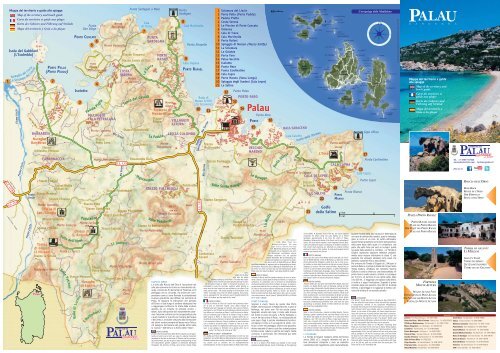
Mappa del territorio e guida alle spiagge<br />
Map of the territory and beach guide<br />
Carte du territoire et guide aux plages<br />
Karte des Gebietes und Führung auf Strände<br />
Mapa del territorio y Guía a las playas<br />
Spiaggia<br />
Fiume Liscia<br />
< Santa Teresa<br />
< Tempio<br />
< Santa Teresa - Tempio<br />
Fiume Liscia<br />
del Liscia<br />
(La Sciumara del<br />
S.S. 133<br />
Fiume Liscia<br />
Liscia)<br />
Valle<br />
Valle<br />
Patrona<br />
dell’Olmo<br />
di<br />
Valle<br />
Luchia<br />
Punta<br />
Don Diego<br />
Padula<br />
Paduledda<br />
Nuraghe<br />
di Luchia<br />
Piatta<br />
I Nalbunacci<br />
Monte<br />
Don Diego<br />
Rio Scopa<br />
Li<br />
Rio Scopa<br />
Iunturi<br />
4.73<br />
La<br />
Tanca dei Cavalli<br />
Monte<br />
Canu<br />
Punta Sardegna a Mare<br />
Cala<br />
di Trana<br />
7<br />
Sarra<br />
La<br />
Stazzareddu<br />
Valle<br />
Padula<br />
110.68<br />
Paduleddi<br />
Punta<br />
Sardegna<br />
8<br />
Cala Martinella<br />
Ponte<br />
Surraeddu<br />
La visita alla Roccia dell’Orso è l’occasione non<br />
solo per osservare da vicino un monumento naturale,<br />
conosciuto fin dai tempi di Tolomeo, ed il<br />
paesaggio che lo circonda, ma anche per comprendere<br />
come si sono formate le straordinarie<br />
sculture granitiche così diffuse nel territorio di<br />
Palau. Si seguono le indicazioni che portano<br />
all’Orso e si sale lungo il sentiero attrezzato fino<br />
a raggiungere la Roccia. Si tratta della scultura<br />
operata da un insieme di processi erosivi, i<br />
tafoni, tipici del granito ed è sorprendente osservare<br />
l’enorme scultura con la consapevolezza che<br />
a quel risultato si è giunti per l’azione dell’acqua<br />
e del vento. L’erosione che porta alla formazione<br />
dei tafoni avviene sempre dal basso verso l’alto e<br />
ciò spiega la formazione del grande antro sotto<br />
la “pancia “ dell’Orso e la forma della “testa”.<br />
CAPO D’ORSO<br />
A visit to the Roccia dell’Orso (Bear Rock) will give you the opportunity<br />
not only to get a bird’s eye view of a natural monument<br />
mentioned as far back as the times of Tolomeo and the surrounding<br />
environment, but also to gain a better understanding of how<br />
the extraordinary granite sculptures so extensively distributed<br />
throughout the territory of Palau were formed. Simply follow<br />
S.S. 125<br />
< Olbia<br />
Rio Surrau<br />
Rio Surrau<br />
Valle<br />
1 Sciumara del Liscia<br />
2 Porto Pollo (Porto Puddu)<br />
3 Padula Piatta<br />
4 Costa Serena<br />
5 Le Piscine di Porto Cuncatu<br />
6 Talmone<br />
7 Cala di Trana<br />
8 Cala Martinella<br />
9 Porto Rafael<br />
10 Spiaggia di Nelson (Mezzo Schifo)<br />
11 La Sciumara<br />
12 La Galatea<br />
13 Porto Faro<br />
14 Palau Vecchio<br />
15 Isolotto<br />
16 Punta Nera<br />
17 Punta Cardinalino<br />
18 Cala Capra<br />
19 Porto Mannu (Vena Longa)<br />
20 Spiaggia degli Svedesi (Cala Lepre)<br />
21 Le Saline<br />
Santu Baingiu<br />
indications<br />
for the Bear<br />
and take the beaten<br />
pathway leading up to the Rock. The latter was sculpted<br />
by a series of erosive processes typically observed in granite<br />
formations known as ‘tafoni’ or honeycomb structures; it is<br />
remarkable to view the enormous sculpture whilst bearing in<br />
mind how the final shape has been dictated by the effect of the<br />
wind and the water.. The erosion leading to the formation of the<br />
‘tafoni’ invariably occurs from the bottom upwards, thus providing<br />
an explanation for the extensive cavern situated beneath the<br />
“belly” of the Bear and the shape of the “head”.<br />
CAPO D’ORSO<br />
La visite à la Roche de l’Ours est l’occasion non seulement d’observer<br />
de près un monument naturel, connu depuis l’époque de<br />
Ptolémée ainsi que le paysage qui l’entoure, mais aussi de comprendrecomment<br />
se sont formées les extraordinaires sculptures de granit<br />
très diffuses sur le territoire de Palau. Il suffit de suivre les indications<br />
qui amènent jusqu’à l’Ours et de monter le long du sentier<br />
balisé jusqu’à la Roche. Il s’agit d’une sculpture opérée par un<br />
ensemble de processus d’érosion, de taphonomie, typiques du granit et<br />
il est surprenant d’observer l’énorme sculpture en ayant conscience<br />
que ce résultat a été atteint grâce à l’action de l’eau et du vent.<br />
L’érosion qui amène à la taphonomie opère toujours du bas vers le<br />
haut, ce qui explique la formation de la grande antre sous le<br />
“ventre” de l’Ours et la forme de la “tête”.<br />
CAPO D’ORSO - BÄRENKAP<br />
Ein Ausflug zum Roccia dell’Orso oder Bärenfelsen ist nicht nur eine<br />
Gelegenheit, aus nächster Nähe ein Naturdenkmal, das schon zu Zeiten<br />
Ptolemäus bekannt war, und die Landschaft, die es umgibt zu betrachten,<br />
sondern auch zu verstehen, wie die außergewöhnlichen<br />
Granitskulpturen, die man im ganzen Gebiet von Palau finden kann,<br />
Le<br />
Baragge<br />
La Multa<br />
1 km<br />
1 mi<br />
Porto Ulisse<br />
112.34<br />
BAIA SARACENO<br />
Cala Casotto<br />
entstanden<br />
sind. Man folgt den<br />
Hinweisschildern, die zum<br />
Capo d’Orso führen und folgt<br />
dem Wanderweg hinauf bis zum Felsen.<br />
Es handelt sich um Skulpturen, die durch<br />
das Miteinander verschiedener erosiver<br />
Prozesse entstanden sind, die typischen<br />
Granit-Tafonifelsen. Bei der Betrachtung dieses<br />
enormen Gebildes ist es erstaunlich zu bedenken,<br />
dass es durch die bloße Wirkung von Wasser<br />
und Wind entstanden ist, beginnend mit der Unterspülung von einzelnen<br />
Felsteilen. Die Erosion, die zur Bildung der Tafonifelsen führt, findet<br />
immer von unten nach oben statt, was die Entstehung der großen<br />
Höhle unter dem „Bauch des Bären“ sowie dessen Kopfform erklärt.<br />
CAPO D’ORSO<br />
Visitando la Roccia dell'Orso podemos observar de cerca un monumento<br />
natural, conocido desde el tiempo de Tolomeo, y el paisaje circunstante<br />
y asi comprender como se formaron las extraordinarias<br />
esculturas de granito del territorio de Palau. Se siguen las indicaciones<br />
que llevan hasta el Orso y se sube por un sendero hasta la Roccia.<br />
Se trata de una escultura natural realizada por la erosión del agua<br />
y del viento típica del granito, Tafoni. La erosión que forma los<br />
Tafoni se produce siempre desde abajo hacia el alto y por eso se explica<br />
la enorme caverna bajo la “pancia” (panza) del Orso y la forma<br />
de la “testa” (cabeza).<br />
PORTO RAFAEL<br />
Sognare è vivere. Nasce da questa idea Porto<br />
Rafael, dall’intuizione di Rafael Neville, Conte di<br />
Berlanga, nei primi anni ’60 del secolo scorso.<br />
Spagnolo, amante del mare, il conte volle trovare<br />
nel tratto di costa che porta a Punta Sardegna, a<br />
circa 4 km dal centro di Palau, la realizzazione dei<br />
suoi sogni. Oggi il piccolo insediamento turistico,<br />
scomparso il conte e il suo seguito di artisti, continua<br />
a vivere nel paesaggio, attorno alla piazzetta,<br />
ottimo esempio di come si può fare urbanizzazione<br />
turistica senza rubare lo spirito dei luoghi. Nelle<br />
vicinanze, il porticciolo, ben attrezzato pur nelle<br />
piccole dimensioni.<br />
PORTO RAFAEL<br />
To live is to dream. Porto Rafael was founded on this concept<br />
expressed by Rafael Neville, Count of Berlanga, at the beginning<br />
Punta dello Stintino<br />
Monte Razzicheddu<br />
74.73<br />
L'Orso<br />
Monte di lu Lepara<br />
CALA DI LEPRE<br />
Stazzo<br />
le Saline<br />
21<br />
LE SALINE<br />
20<br />
Golfo<br />
delle Saline<br />
Punta dell’Orso<br />
110.98<br />
CALA CAPRA<br />
19<br />
PORTO<br />
MANNU<br />
1 km<br />
1 mi<br />
of the 1960’s. A Spaniard, lover of the sea, the Count hoped to<br />
accomplish his dream along the coast leading up to Punta<br />
Sardegna, approximately 4 km from the centre of Palau.<br />
Nowadays, following the demise of the Count and his entourage of<br />
artists, this small tourist complex is well integrated into the landscape<br />
surrounding the square, constituting an excellent example of<br />
how tourist town planning can effectively be achieved without<br />
spoiling the essence of the location. A small well-equipped tourist<br />
harbour faces directly onto the sea.<br />
PORTO RAFAEL<br />
Rêver veut dire vivre. Porto Rafael naît de cette idée, de l’intuition<br />
de Rafael Neville, Conte de Berlanga, au début des années<br />
60 du siècle dernier. Espagnol, amant de la mer, le conte a voulut<br />
réaliser ses rêves dans la portion de côte qui va jusqu’à Punta<br />
Sardegna, à environ 4 Km du centre de Palau. Aujourd’hui, le<br />
conte et sa suite d’artistes ayant disparus, la petite implantation<br />
touristique est insérée dans le paysage, autour d’une petite place,<br />
parfait exemple de réalisation d’une urbanisation touristique qui<br />
préserve l’esprit des lieux. En bord de mer, le port de plaisance est<br />
bien équipé, même s’il reste de dimensions modestes.<br />
PORTO RAFAEL<br />
Träumen heißt Leben. Aus dieser Idee entsteht Porto Rafael, dank einer<br />
Intuition von Rafael Neville, Graf von Berlanga, Anfang der 60er<br />
Jahre des vorigen Jahrhunderts. Neville, Spanier, mit einer Passion für<br />
das Meer, wollte im Küstenabschnitt, der nach Punta Sardegna führt,<br />
circa 4 km von Palau entfernt, seine Träume realisieren. Heute ist der<br />
kleine touristische Ort, nach dem Verschwinden des Grafen und seines<br />
künstlerischen Gefolges, um den kleinen Hauptplatz herum gelegen<br />
und in die Landschaft eingefügt, ein optimales Beispiel dafür, wie man<br />
touristische Urbanisierung durchführen kann, ohne einen Ort seiner<br />
Ausstrahlung zu berauben. Direkt am Meer befindet sich der kleine<br />
aber dennoch gut ausgestattete Hafen.<br />
PORTO RAFAEL<br />
Soñar y vivir. De esta idea e intuición de Rafael Neville, Conte di<br />
Berlanga,. español y amante del mar, nace Porto Rafael a inicio de los<br />
años 60 del siglo pasado. El conte encuentra en la costa hacía Punta<br />
Sardegna, a casi 4 Km. del centro de Palau, el lugar para realizar su<br />
sueño. Hoy, el pequeño centro turístico, a pesar de la desaparición del<br />
conte y de sus amigos artistas, continua a vivir en medio a la naturalezza<br />
y a la “piazzetta” y son un optimo ejemplo de como la urbanización<br />
turística no siempre roba el espíritu del lugar. El minúsculo puerto<br />
bién equipado da refugio a pequeñas embarcaciones.<br />
LI MIZZANI<br />
Le Tombe di Giganti risalgono all'età del bronzo<br />
antico (2000 a.C.), vengono chiamate così per le<br />
loro dimensioni ciclopiche e sono un elemento<br />
caratteristico del megalitismo sardo. Generalmente,<br />
18<br />
Punta Bianca<br />
L’arcipelago della Maddalena<br />
Cala Capra<br />
Capo d'Orso<br />
17<br />
Punta Cardinalino<br />
Punta Capra<br />
la parte frontale della loro struttura è delimitata da<br />
una sorta di semicerchio (esedra), quasi a simboleggiare<br />
le corna di un toro. Al centro dell'esedra,<br />
queste Tombe presentano un'enorme stele granitica,<br />
nella parte bassa della quale c'è un'apertura, che<br />
porta alla parte forse più sacra ai nuragici: quella<br />
occupata dalle sepolture a corridoio. Le Tombe di<br />
Giganti ospitavano sepolture collettive probabilmente<br />
senza nessuna distinzione di classe. È così<br />
possibile che venissero utilizzate come ossari che<br />
potevano contenere fino a 200 scheletri.<br />
Per arrivare alla Tomba di Giganti di Li Mizzani si<br />
parte da Palau e si prende la strada SS 133 per Santa<br />
Teresa Gallura, all'altezza del ristorante Vecchia<br />
Gallura si svolta a sinistra su una strada asfaltata. Al<br />
primo bivio si svolta ancora a sinistra e si prosegue<br />
per 4,5 Km. Al termine di una ripida salita, dopo<br />
circa 500 mt., si raggiunge uno spiazzo sulla destra,<br />
si svolta e si segue l'indicazione. Superato il primo<br />
cancello, dopo aver percorso circa 200 mt. di strada<br />
sterrata, si parcheggia e si raggiunge la tomba, ubicata<br />
sulla sinistra di un secondo cancello.<br />
LI MIZZANI<br />
The Giant's Tombs date back to the Bronze Age (2000 BC.),<br />
they are called this way because of their size and they represent<br />
a characteristic element of the Sardinian Megalithism.<br />
Generally the front part of the Tomb features a horned semi-circular<br />
forecourt which was probably used as a meeting place for<br />
rituals. In the center of the exedra, the tombs present an enormous<br />
stele carved out of granite and the lower part is characterized<br />
by a small opening which leads to the most sacred part: the<br />
one occupied by the collective burials. The Giant's Tombs could<br />
probably hold about 200 bodies, without distinction of social class,<br />
and it is thus possible that they were used as ossuaries.<br />
To reach the Giant's Tomb of “Li Mizzani” departing from<br />
Palau you must take the SS 133 road to Santa Teresa Gallura<br />
and once you've reached the restaurant “Vecchia Gallura” (after<br />
approximately 3 km) you will make a left turn on a paved road<br />
and go straight on. At the first crossroad, take a left and follow<br />
for about 4,5 km. After having covered an uphill keep going for<br />
500 mt. until you find a pitch with an entrance on the right. At<br />
this point, after crossing the first gate, you will enter a dirt road,<br />
go on for 200 mt, park the car and enter the second gate. The<br />
Tomb will be on the immediate left.<br />
Foto: Gian Mario Pedroni, Pier Mario Bulciolu. Grafica: Dario Maiore - Taphros - 0789 51785<br />
Mappa del territorio e guida<br />
alle spiagge<br />
Map of the territory and<br />
beach guide<br />
Carte du territoire et<br />
guide aux plages<br />
Karte des Gebietes und<br />
Führung auf Strände<br />
Mapa del territorio y<br />
Guía a las playas<br />
PIAZZA PORTO RAFAEL<br />
PORTO RAFAEL SQUARE<br />
PLACE DE PORTO RAFAEL<br />
DER PLATZ VON PORTO RAFAEL<br />
PLAZA DE PORTO RAFAEL<br />
FORTEZZA<br />
MONTE ALTURA<br />
MOUNT ALTURA FORT<br />
FORTIFICATION DU MONT ALTURA<br />
DIE FESTUNG VON MONTE ALTURA<br />
FORTALEZA MONTE ALTURA<br />
Tel. +39 0789 707025<br />
www.palauturismo.com · turismo@palau.it<br />
find us on<br />
ROCCIA DELL’ORSO<br />
BEAR ROCK<br />
ROCHE DE L’OURS<br />
DER BÄRENFELS<br />
ROCCIA DELL’ORSO<br />
TOMBA DI GIGANTI<br />
LI MIZZANI<br />
GIANT’S TOMB<br />
TOMBES DES GÉANTS<br />
DIE GIGANTENGRÄBER<br />
TUMBA DE LOS GIGANTES<br />
NUMERI UTILI<br />
Comune · P.zza Popoli d’Europa,1 · Tel. 0789-770801<br />
Croce Rossa · Via degli Achei · Tel.0789-708580<br />
Punto Info Palau · Ufficio Turismo · Palazzo Fresi · Tel. 0789-707025 Chiesa · Via Don Occhioni · Tel. 0789-709607<br />
CCN Orsus Mediterraneus · Via Nazionale, 2 · Tel. 0789-771000 Biblioteca Comunale · Palazzo Fresi · Tel. 0789 -771021<br />
Museo Etnografico · Loc. Montiggia · Tel. 329-6041373<br />
Poste Italiane · Via R. Margherita · Tel. 0789-708527<br />
Carabinieri · Via Nazionale, 127 · Tel. 0789-709503<br />
Guardia Medica · Via degli Achei · Tel. 0789-709396<br />
Polizia Municipale · Via Omero, 1 · Tel. 0789-770870<br />
Guardia Medica Turistica · Via degli Achei · Tel. 0789-708537<br />
Polizia di Stato · Via Capo d'Orso snc · Tel. 0789-708000<br />
Banco di Sardegna · Via Fonte Vecchia · Tel. 0789-709140<br />
Guardia di Finanza · Via Nazionale, 113 · Tel. 0789-709510<br />
Vigili del Fuoco Olbia · Tel. 0789 22222<br />
Banca di Sassari · Via Roma, 9 · Tel. 0789 -708148<br />
Corpo Forestale · Loc: Vecchio Marino · Tel. 0789-708778<br />
Unicredit Banca · Via Nazionale · Tel. 0789-1895100<br />
Protezione Civile · Via degli Achei · Tel. 0789-708660<br />
Farmacia · Via delle Ginestre, 19 · Tel. 0789-709516<br />
Ufficio Marittimo · P.zza del Molo · Tel. 0789-709419<br />
TAXI · Piazza del Molo · Tel. 0789-709218
LI MIZZANI<br />
Les Tombes des Géants datent à l'age du bronze (2000 Av. J.C.),<br />
ils sont appelées ainsi pour leur dimensions gigantesques et sont<br />
un élément caractéristique du mégalithisme de la Sardaigne. En<br />
général, l'avant de leur structure est bornée par une sorte de<br />
demi-cercle (exèdre), qui symbolise les cornes d'un taureau. Au<br />
centre de l'exèdre, les Tombes ont un énorme stèle de granit, dans<br />
la partie inférieure de laquelle il y a un ouverture, qui mène à<br />
la partie la plus sacrée aux nuragiques: ce qui était occupée par<br />
les sépultures à couloir. Les Tombes des Géants accueillaient<br />
sépultures collectives, peut-être sans aucune distinction de classe.<br />
Peut-être qu'ils étaient utilisées comme ossuaires qui pourraient<br />
contenir jusqu'à 200 squelettes.<br />
Pour arriver à la Tombe des Géant de Li Mizzani on parte de<br />
Palau et on prend la route SS133 pour Santa Teresa Gallura,<br />
au restaurant La Vecchia Gallura on tourne à gauche dans la<br />
route goudronnée. Au première carrefour, on tourne encore à<br />
gauche et on continue pour 4,5 Km. A' la fin d'une raide montée,<br />
après environ 500 mt, on arrive à un espace ouvert sur la<br />
droite, on tourne et on suit l'indication. Après la première grille,<br />
après avoir parcouru environ 200 mt. de chemin de terre, on<br />
gare la voiture et on atteint la tombe, qui est située sur la gauche<br />
d'un deuxième grille.<br />
LI MIZZANI<br />
Die Tombe dei Giganti (Gigantengräber) stammen aus der<br />
Bronzezeit (ca. 2.000 v. Chr.) und sie heissen so wegen ihrer<br />
riesigen Ausmasse, die für die sardische Megalithzeit charakteristisch<br />
sind. Ihre Vorderseite ist im allgemeinen von einer<br />
Art Säulenhalbkreis begrenzt, der ein Stierhorn symbolisieren<br />
soll. Im Zentrum dieses Säulenhalbkreises steht eine enorme<br />
Granitstele, in deren unterem Teil eine Öffnung ist, die in<br />
den wohl heiligsten Bereich der Nuraghenkultur führt: dieser<br />
Bereich ist ein Gang mit Gräbern. Die Gigantengräber<br />
beherbergten Gemeinschaftsgräber, vermutlich ohne<br />
Standesunterschiede. Möglicherweise wurden sie als Beinhaus<br />
für bis zu 200 Skelette benutzt.<br />
Um zum Tomba dei Giganti von Li Mizzani zu kommen,<br />
nimmt man von Palau die SS 133 nach Santa Teresa di<br />
Gallura und biegt beim Restaurant „Vecchia Gallura“ nach<br />
links auf eine Asphaltstraße ab. An der ersten Kreuzung biegt<br />
man wieder nach links ab und folgt der Straße ca. 4,5 km<br />
weit. Nach einem steilen Anstieg erreicht man nach ca. 500<br />
m einen Platz rechter Hand. Von dort folgt man der<br />
Beschilderung. Hinter dem ersten Gitter kann man nach ca.<br />
200 m Feldweg parken und erreicht das Gigantengrab links<br />
von einem zweiten Gitter.<br />
LI MIZZANI<br />
Las Tumbas de los Gigantes se remontan a la edad del bronce<br />
antiguo (2.000 a.C.), se llaman asì por sus enormes dimensiones,<br />
y son un elemento caracteristico del megalitismo sardo.<br />
Normalmente, la parte frontal de su estructura está delimitada<br />
por una especie de semicirculo (esedra) que parece simbolizar<br />
los cuernos de un toro. En el centro, estas tumbas presentan una<br />
enorme estela de granito en la cual, en la parte baja está una<br />
apertura, que nos lleva a la zona más sagrada a los nuragicos:<br />
la zona de los entierros "de pasillo". Las Tumbas de los<br />
Gigantes acogían entierros colectivos probablemente sin ninguna<br />
distinción de clase.<br />
Tambien es posible que fueran utilizadas como osario que<br />
podìan contener hasta 200 esqueletos. Para llegar a la Tumba<br />
del los Gigantes de "Li mizzani" desde Palau se coge la carretera<br />
SS133 dirección S.Teresa Gallura, a la altura del restaurante<br />
"Vecchia Gallura" se gira a mano izquierda en una carretera<br />
asfaltada. Al primer cruce se gira a mano izquirda y<br />
luego todo recto por 4,5 Km. Al final de una escapada tras 500<br />
m, se llega a una explanada en la derecha, se gira y se siguen<br />
las indicaciones. Después de la primera cancela, tras tras haber<br />
percorrido 200 mt. de camino de carretera no asfaltada se<br />
puede aparcar y se llega a la tumba, que se encuentra a la<br />
derecha de otra cancela.<br />
LE FORTIFICAZIONI<br />
Lo sviluppo delle fortificazioni militari sulle<br />
isole dell’arcipelago non interessò la costa<br />
palaese fino al 1887, quando fu deciso un<br />
piano di fortificazioni che si concretizzò<br />
all’inizio nelle due fortezze di Monte Altura e<br />
di Capo d’Orso. La fortificazione di Monte<br />
Altura è indubbiamente la più imponente e<br />
svolse un ruolo fino alla seconda guerra mondiale.<br />
Recentemente ristrutturata, è meta di<br />
visite guidate ed ospita la mostra “Itinerario<br />
delle Fortificazioni” e la Galleria d’Arte<br />
Contemporanea “Palau Arte”.<br />
FORTIFICATIONS<br />
The development of military fortifications throughout<br />
the islands of the archipelago did not affect the coast of Palau<br />
up until 1887 when a fortification plan was put into practice<br />
with the initial construction of two forts on Mount Altura<br />
and at Capo d’Orso. The Mount Altura Fort is undoubtedly<br />
the most imposing and was in use up until the Second World<br />
War. It has recently been renovated; guided visits are now<br />
available and it hosts the exhibition “Itinerary of<br />
Fortifications” and the “Palau Arte” Gallery of Modern Art.<br />
LES FORTIFICATIONS<br />
Le développement des fortifications militaires sur les îles<br />
de l’Archipel ne concerna plus la côte de Palau jusqu’en 1887<br />
lorsque fut mis sur pied un plan de fortifications qui se concrétisa<br />
dans la réalisation, d’abord, des deux forteresses du Mont<br />
Altura et de Capo d’Orso. La fortification du Mont Altura est<br />
sans aucun doute la plus imposante et elle a joué un rôle<br />
important jusqu’à la seconde guerre mondiale; récemment<br />
restructurée, fait l’objet de visites guidées et elle est également<br />
le siège de l’exposition “Itinerario delle Fortificazioni”<br />
(Itinéraire des Fortifications) ainsi que celui de la Galerie<br />
d’Art Contemporain “Palau Arte” (Palau Art).<br />
4 Costa Serena<br />
DIE FESTUNGEN<br />
Die Küste von Palau nicht von der Erstellung militärischer<br />
Festungen auf den Inseln des Archipels betroffen, bis zum<br />
Jahre 1887, als ein Plan für weitere Festungen beschlossen<br />
wurde, der zunächst den Bau der zwei Anlagen in Monte<br />
Altura und Capo d’Orso. Die Festung von Monte Altura ist<br />
zweifellos die eindrucksvollste und war bis zum zweiten<br />
Weltkrieg von Bedeutung. Ist kürzlich restauriert worden und<br />
ein beliebtes Ziel für Führungen und Besichtigungen.<br />
Außerdem beherbergt sie die Ausstellung “Itinerario delle<br />
Fortificazioni” (Anm. d. Ü.: Rundgang durch die Festungen)<br />
und die Galerie für zeitgenössische Kunst “Palau Arte”.<br />
LAS FORTIFICACIONES<br />
El desarrollo de las fortificaciones militares del archipiélago<br />
no tuvieron en cuenta la costa de Palau hasta que<br />
en1887 se decidio un plan de fortificaciones que se concretizó<br />
en la construccción de dos fortalezas Monte Altura y Capo<br />
d'Orso.Sin duda, la fortificación de Monte Altura es la más<br />
imponente y tuvo un rol hasta la segunda guerra mundial;<br />
apenas restaurada, es meta de visitas turísticas y sede la la<br />
exposición “Itinerario delle Fortificazioni” y de la Galleria<br />
d'Arte Contemporanea “Palau Arte”.<br />
1 Sciumara del Liscia 2 Porto Pollo (Porto Puddu)<br />
3 Padula Piatta<br />
5 Le Piscine di Porto Cuncatu 6 Talmone 7 Cala di Trana<br />
8 Cala Martinella 9 Porto Rafael 10 Spiaggia di Nelson (Mezzo Schifo) 11 La Sciumara 12 La Galatea<br />
13 Porto Faro 14 Palau Vecchio 15 L’Isolotto 16 Punta Nera 17 Punta Cardinalino<br />
18 Cala Capra 19 Porto Mannu (Vena Longa)<br />
20 Spiaggia degli Svedesi (Cala Lepre) 21 Le Saline<br />
Dimmi di che spiaggia sei<br />
Lungo i 25 chilometri di costa del territorio di Palau sono 21 le spiagge piccole<br />
e grandi che si offrono al visitatore, ciascuna con caratteristiche diverse. La<br />
maggior parte sono facilmente raggiungibili. Chi vuole invece la spiaggia<br />
esclusiva deve impegnarsi un po’ per conquistarla, ma ne vale sempre la pena. Nel<br />
Golfo delle Saline ci sono ben 4 spiagge: quella delle Saline, quella degli Svedesi,<br />
Vena Longa (Porto Mannu) e Cala Capra. Nei pressi della cittadina, le spiagge di<br />
Punta Nera e dell’Isolotto sono facilmente raggiungibili, come sull’altro versante<br />
quelle di Palau Vecchio e Porto Faro. Seguendo il litorale si trova poi la spiaggia di<br />
La Galatea, mentre la spiaggia di Palau per antonomasia è quella della Sciumara al<br />
fondo della rada di Mezzo Schifo: questo nome non ha nulla a che vedere con il<br />
ribrezzo, ma ricorda un antico tipo di imbarcazione di servizio per le grandi navi e<br />
probabilmente è da collegare con la presenza ottocentesca della flotta inglese<br />
dell’Ammiraglio Nelson proprio in questa rada, così come Cala Inglese nei pressi di<br />
Porto Rafael, che a sua volta ha la piazzetta affacciata sulla spiaggia omonima. La<br />
Sciumara si raggiunge dal centro di Palau. La piccolissima spiaggia di Cala Martinella<br />
si raggiunge invece dalla strada che conduce al faro di Punta Sardegna. Per chi la spiaggia<br />
bellissima vuole conquistarsela c’è Cala di Trana, di sabbia candida, con alle<br />
spalle un complesso dunale, solo in parte colonizzato da piante pioniere. La si raggiunge<br />
via mare oppure a piedi attraverso un sentiero, dopo aver percorso uno sterrato<br />
che si imbocca dalla strada che da Palau porta a Costa Sere-na. Anche le spiagge<br />
di Porto Cuncato e Talmone vanno conquistate con una camminata che inizia dalla<br />
rotonda raggiungibile da Costa Serena. Al fondo di Porto Puddu, nella profonda<br />
insenatura che si addentra verso Costa Serena c’è un’altra bellissima spiaggia, in un<br />
tratto dove le correnti trasformano continuamente il rapporto mare e terra.<br />
Poco più ad est c’è la lunga spiaggia delle Dune di Porto Puddu e di Porto Liscia, con<br />
alle spalle la zona umida di Padula Piatta. Più in là ancora, raggiungibile da Porto<br />
Puddu, c’è la spiaggia dell’istmo che congiunge alla terraferma l’Isuledda (nota anche<br />
come Isola dei Gabbiani).<br />
Questo tratto di costa è plasmato dal vento, dalle correnti e dagli apporti del fiume<br />
Liscia che segna il confine di Palau ad occidente e che sta alle spalle del complesso<br />
dunale della Sciumara del Liscia, un angolo di natura dal fascino inestimabile, dove si<br />
radunano a cercare il vento surfisti di tutto il mondo.<br />
TELL ME HOW YOUR BEACH SHOULD BE<br />
Along the 25 kilometres of coast present throughout the Palau territory, 23 beaches ranging from large to small are at<br />
the visitor’s disposal, each completely different from the next. Some are better suited for those who wish to have access to all types<br />
of commodity without having to lift a finger. On the contrary, those seeking an exclusive beach will have to toil a little to reach it,<br />
although it will have been well worth the trouble. The “Golfo delle Saline” comprises 3 different beaches: Vena Longa (Porto<br />
Mannu), the beach of the Capo d’Orso camp site and Cala Capra. Nearer to the town the beaches of Punta Nera and Isolotto are<br />
within easy reach, as are those of Palau Vecchio and Porto Faro on the other side. Proceeding along the coast you come to the beach<br />
of La Galatea, whilst the beach conventionally thought of as the beach of Palau is that of Sciumara situated at the end of the<br />
Mezzo Schifo roadstead. The term “Mezzo Schifo” (repugnance) was not used to convey the meaning of disgust, but rather recalls<br />
an ancient type of sea craft used in assisting the large ships and can likely be dated back to the presence in the roadstead during<br />
the Nineteenth century of the English fleet led by Admiral Nelson. The same applies to the bay of Cala Inglese (English Cove)<br />
adjacent to Porto Rafael, with its square overlooking the beach of the same name. La Sciumara can be reached either from the<br />
centre of Palau or from the road that leads to Porto Rafael. The tiny beach of Cala Martinella can be reached from the road leading<br />
to the lighthouse at Punta Sardegna. Those wishing to succeed in gaining access to their own magnificent beach may visit the<br />
white sandy beach of Cala di Trana with its backdrop of dunes only partly colonised by indigenous plants. It can be reached by sea<br />
or along a footpath, after having crossed an unmade up area leading from the road running from Palau to Costa Serena. Access<br />
to the beaches of Porto Cuncato and Talmone must also be deserved, firstly by means of a walk starting from the rotunda at Costa<br />
Serena. At the end of Porto Puddu, in the deep creek snaking towards Costa Serena another breathtaking beach is to be found in<br />
a stretch of coast where the currents are continually modifying the relationship between the sea and the land. Slightly further east<br />
is the long beach of the Dunes of Porto Puddu and Porto Liscia with the marshland of Padula Piatta in the background. Even<br />
further on, through the district of Porto Puddu, you will come to the beach at the isthmus which links Isuledda to the mainland<br />
(also known as the Isola dei Gabbiani / Isle of Gulls). This stretch of coast is hewn by the wind, the currents and by the motion of<br />
the river Liscia marking the boundary of Palau to the west and backing onto the dunes of Sciumara del Liscia, a natural area of<br />
inestimable appeal where surfers from all over the world gather to take advantage of the wind.<br />
DIS-MOI DE QUELLE PLAGE TU ES<br />
Le long des 25 kilomètres de côte du territoire de Palau, 23 plages petites et grandes s’offrent au visiteur, chacune ayant<br />
des caractéristiques différentes des autres. Certaines sont équipées pour ceux qui veulent toutes les commodités sans bouger le petit<br />
doigt. Ceux qui désirent, au contraire, une plage exclusive, doivent se bouger pour y accéder, mais cela en vaut toujours la peine.<br />
Dans le Golfe des Salines, il y a 3 plages : celle de Vena Longa (Porto Mannu), celle du camping Capo d’Orso et celle de Cala Capra.<br />
Près de la ville, les plages de Punta Nera et de l’Isolotto sont faciles d’accès, ainsi que sur l’autre versant, les plages de Palau Vecchio<br />
et Porto Faro. En suivant le littoral, l’on trouve la plage de La Galatea, tandis que la plage en titre de Palau est celle de la Sciumara<br />
au fond de la rade de Mezzo Schifo : ce nom n’a rien a voir avec le dégoût, mais il rappelle un ancien type d’embarcation de service<br />
pour les grands navires et il est probablement lié à la présence durant le XIX ème siècle de la flotte anglaise de l’Amiral Nelson<br />
dans cette rade, tout comme à Cala Inglese dans les environs de Porto Rafael dont la petite place se trouve face à la plage du même<br />
nom. La Sciumara est accessible par le centre de Palau ou bien par la route qui conduit à Porto Rafael. La petite plage de Cala<br />
Martinella est accessible par la route qui conduit au phare de Punta Sardegna. Pour ceux qui veulent conquérir une très belle plage,<br />
il y a Cala di Trana, une plage de sable immaculé, adossée à un ensemble de dunes en partie colonisé par des plantes pionnières. Cette<br />
plage est accessible par la mer ou bien à pied en suivant un sentier, après avoir parcouru un chemin de terre depuis la route qui va<br />
de Palau à Costa Serena. Les plages de Porto Cuncato et de Talmone également ne sont accessibles qu’après une promenade qui part<br />
de la rotonde accessible depuis Costa Serena. Au fond de Porto Puddu, dans la profonde crique qui va jusqu’à Costa Serena, se trouve<br />
une autre plage magnifique, à un endroit où les courants transforment continuellement le rapport mer et terre. Un peu plus à<br />
l’est, se trouve la longue plage des Dunes de Porto Puddu et de Porto Liscia, adossé à la zone humide de Padula Piatta. Au-delà,<br />
accessible par le hameau de Porto Puddu, se trouve la plage de l’isthme qui relie l’Isuledda (connue aussi sous le nom d’Ile des<br />
Goélands) à la terre ferme. Cette portion de côte est façonnée par le vent, par les courants et par les apports du fleuve Liscia qui<br />
marque la frontière de Palau à l’ouest et qui est adossé à l’ensemble des dunes de la Sciumara du fleuve Liscia, une portion de nature<br />
à l’attrait inestimable où se retrouve des surfeurs du monde entier à la recherche du vent idéal.<br />
STRÄNDE ÜBER STRÄNDE<br />
Entlang der 25 km langen Küste von Palau gibt es 23 kleine und große Strände, von denen sich ein jeder dem Besucher<br />
mit verschiedenen Charakteristiken präsentiert. Einige Strände bieten jeglichen Komfort für diejenigen, die keinen Finger rühren<br />
wollen. Wer einen exklusiven Strand bevorzugt, muss sich allerdings etwas anstrengen, um ihn zu erreichen, aber das ist die Sache<br />
in jedem Fall wert. Im Golf der Salinen gibt es gleich drei Strände: Vena Longa (Porto Mannu), der Strand des Campingplatzes<br />
Capo d’Orso und der von Cala Capra. In der Nähe der Stadt sind die Strände Punta Nera und Isolotto einfach zu erreichen und<br />
auf der anderen Seite die Strände von Palau Vecchio und Porto Faro. Entlang der Küste trifft man dann auf den Strand La<br />
Galatea, während der Strand von Palau schlechthin der Sciumara-Strand am Ende der Reede von Mezzo Schifo ist. Der Name<br />
der Reede hat nichts mit Abscheu (Anm. d. Ü.: ital. “schifo“ = Ekel) zu tun, sondern erinnert an eine alte Art von Hilfsbooten<br />
zu Diensten großer Schiffe und ist wahrscheinlich auf die Anwesenheit der Flotte Admiral Nelsons im 19. Jahrhundert in eben<br />
dieser Bucht zurückzuführen, wie auch Cala Inglese in der Nähe von Porto Rafael, deren kleiner Hauptplatz auf einen gleichnamigen<br />
Strand blickt. La Sciumara kann man sowohl vom Zentrum Palaus aus als auch von der Straße, die nach Porto Rafael<br />
führt, erreichen. Den winzigen Strand Cala Martinella hingegen erreicht man von der Straße aus, die zum Leuchtturm von<br />
Punta Sardegna führt. Wer sich seinen Traumstrand erobern will, sollte Cala di Trana mit seinem weißem Sand und dem<br />
Dünenkomplex, nur teilweise von Pionierpflanzen bewachsen, besuchen. Zu erreichen ist dieser Strand über das Meer, oder zu<br />
Fuß über einen Pfad, der von dem unbefestigten Weg abgeht, den man auf der Straße von Palau nach Costa Serena einschlagen<br />
muss. Auch die Strände von Porto Cuncato und Talmone müssen durch eine Wanderung mit Beginn an dem Rondell, das man<br />
von Costa Serena aus erreicht, erobert werden. Am Ende von Porto Puddu, in der tiefen Bucht, die sich Richtung Costa Serena<br />
noch vertieft, gibt es einen weiteren wunderschönen Strand an einer Stelle, wo die Strömungen die Grenze zwischen Meer und<br />
Festland ständig verändern. Etwas weiter im Osten liegt der lange Dünenstrand von Porto Puddu und Porto Liscia. Dahinter<br />
das Feuchtgebiet von Padula Piatta. Noch ein Stück weiter, zu erreichen von Porto Puddu, liegt der Strand der Landenge, welche<br />
Isuledda (auch als Isola dei Gabbiani oder Möweninsel bekannt) mit dem Festland verbindet. Dieser Küstenabschnitt ist vom<br />
Wind, den Strömungen und den Zuflüssen der Liscia geformt. Letztere bildet die Grenze Palaus im Westen und befindet sich<br />
hinter dem Dünenkomplex der Sciumara der Liscia, ein faszinierender von der Natur geschaffener Ort, wo sich Surfer aus der<br />
ganzen Welt auf der Suche nach Wind versammeln.<br />
DIME DE QUE PLAYA VIENES<br />
A lo largo de los 25 km de costa del territorio de Palau, podemos visitar entre grandes y pequeñas, 21 playas cada una con<br />
sus características. La mayor parte de fácil acceso. Quién en cambio desea una playa exclusiva tendrá que empeñarse para conquistarla,<br />
pero quedará satisfecho. En el Golfo delle Saline hay 4 playas: Saline, Svedesi, Vena Longa (Porto Mannu) y Cala Capra.<br />
Desde el casco urbano es muy fácil llegar, por un lado, a las playas de Punta Nera y de Isolotto y por el otro, a las de Palau Vecchio<br />
y de Porto Faro. Siguiendo el litorale se encuentra la playa de La Galatea, mientras la playa más renombrada de Palau es la<br />
Sciumara al final de la ensenada de Mezzo Schifo: este nombre alude a un antiguo tipo de embarcación de servicio en uso en las<br />
grandes naves del ochocientos y recuerda la permanencia de la flota del Almirante Nelson en esta ensenada. También Cala Inglese<br />
en Porto Rafael recuerda el mismo episodio. Desde el centro de Palau se puede alcazar la playa de La Sciumara, en cambio a la<br />
pequeña playa de Cala Martinella se llega desde la carrretera al faro de Punta Sardegna. A Cala di Trana, con arena blanquisima,<br />
se llega por mar o andando por un sendero que se coje desde la carretera de Palau a Costa Serena.<br />
Después de pasar la rotonda de Costa Serena por un sendero se llega a las playas de Porto Cuncato y Talmone. En la profonda<br />
ensenada de Porto Puddu hacia Costa Serena se encuentra una bonita playa en un trecho de mar donde las corrientes marinas<br />
trasforman continuamente el mar y la costa.<br />
A este, frente a la zona húmeda de Padula Piatta, la larga playa de Dune di Porto Puddu y de Porto Liscia, más adelante<br />
desde Porto Puddu llegamos a la playa del istmo que une Isuledda (conocida como Isola dei Gabbiani) a la tierra firme.<br />
Detrás de las dunas de Sciumara del Liscia un trecho de costa, plasmado por el viento, las corrientes marinas y los aportes de<br />
agua dulce del río Liscia, que limita Palau a occidente, nos ofrece un angulo natural de incomparable encanto y reune surfistas<br />
de todo el mundo.


