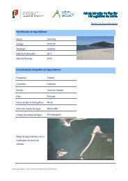
Praia da Mareta
Praia da Mareta
Praia da Mareta

Create successful ePaper yourself
Turn your PDF publications into a flip-book with our unique Google optimized e-Paper software.
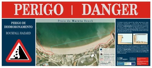
PERIGO<br />
DANGER<br />
PERIGO DE<br />
DESMORONAMENTO<br />
ROCKFALL HAZARD<br />
P r a i a d a M a r e t a B e a c h<br />
A evolução (erosão) natural <strong>da</strong>s arribas processa-se numa<br />
sequência intermitente e descontinua de derroca<strong>da</strong>s<br />
instantâneas, dinâmica que constitui perigo para os utentes<br />
<strong>da</strong>s praias. A FAIXA DE RISCO corresponde à área passível de<br />
ser ocupa<strong>da</strong> pelos resíduos de desmoronamentos e tem<br />
largura igual a 1.5 vezes a altura <strong>da</strong> arriba. Para sua segurança<br />
permaneça afastado do topo e <strong>da</strong> base <strong>da</strong>s arribas, bem como<br />
de penedos (leixões) isolados.<br />
faixa de risco = 1,5 x altura <strong>da</strong> arriba<br />
rockfall hazard area = 1,5 x cliff height<br />
altura <strong>da</strong> arriba<br />
cliff height<br />
N<br />
Você está aqui I You are here<br />
Zona balnear I Bathing zone<br />
Natural cliff evolution (erosion) progresses by intermittent and<br />
discontinuous series of rockfall and cliff collapses. Cliff evolution is a<br />
potential menace for people standing on beaches accumulated at<br />
the cliff base. HAZARD AREAS correspond to areas where it is likely<br />
that effects of debris will be felt and its length equals 1.5 times cliff<br />
height. For your safety, keep away from cliff base and cliff edge, as<br />
well from sea stacks.<br />
Crista <strong>da</strong> arriba I Cliff edge<br />
Faixa de risco I Hazard area<br />
0 20 40 60 80 Metros<br />
Meters<br />
Fotografia aérea I Aerial Photograph<br />
59.1<br />
Rua do Alportel, n.º 10<br />
8 0 0 0 - 2 9 3 F a r o<br />
Tel. +351 289 889 000<br />
Fax +351 289 889 099<br />
presidencia@arhalgarve.pt<br />
w w w . a r h a l g a r v e . p t<br />
Emergência I Emergency<br />
SOS 112<br />
Policia Marítima 282 762 826<br />
Maritime Police<br />
Bombeiros 282 639 285<br />
Fire Brigade
PERIGO<br />
DANGER<br />
PERIGO DE<br />
DESMORONAMENTO<br />
ROCKFALL HAZARD<br />
P r a i a d a M a r e t a B e a c h<br />
A evolução (erosão) natural <strong>da</strong>s arribas processa-se numa<br />
sequência intermitente e descontinua de derroca<strong>da</strong>s<br />
instantâneas, dinâmica que constitui perigo para os utentes<br />
<strong>da</strong>s praias. A FAIXA DE RISCO corresponde à área passível de<br />
ser ocupa<strong>da</strong> pelos resíduos de desmoronamentos e tem<br />
largura igual a 1.5 vezes a altura <strong>da</strong> arriba. Para sua segurança<br />
permaneça afastado do topo e <strong>da</strong> base <strong>da</strong>s arribas, bem como<br />
de penedos (leixões) isolados.<br />
faixa de risco = 1,5 x altura <strong>da</strong> arriba<br />
rockfall hazard area = 1,5 x cliff height<br />
altura <strong>da</strong> arriba<br />
cliff height<br />
N<br />
Você está aqui I You are here<br />
Zona balnear I Bathing zone<br />
Natural cliff evolution (erosion) progresses by intermittent and<br />
discontinuous series of rockfall and cliff collapses. Cliff evolution is a<br />
potential menace for people standing on beaches accumulated at<br />
the cliff base. HAZARD AREAS correspond to areas where it is likely<br />
that effects of debris will be felt and its length equals 1.5 times cliff<br />
height. For your safety, keep away from cliff base and cliff edge, as<br />
well from sea stacks.<br />
Crista <strong>da</strong> arriba I Cliff edge<br />
Faixa de risco I Hazard area<br />
0 20 40 60 80 Metros<br />
Meters<br />
Fotografia aérea I Aerial Photograph<br />
59.2<br />
Rua do Alportel, n.º 10<br />
8 0 0 0 - 2 9 3 F a r o<br />
Tel. +351 289 889 000<br />
Fax +351 289 889 099<br />
presidencia@arhalgarve.pt<br />
w w w . a r h a l g a r v e . p t<br />
Emergência I Emergency<br />
SOS 112<br />
Policia Marítima 282 762 826<br />
Maritime Police<br />
Bombeiros 282 639 285<br />
Fire Brigade
PERIGO<br />
DANGER<br />
PERIGO DE<br />
DESMORONAMENTO<br />
ROCKFALL HAZARD<br />
P r a i a d a M a r e t a B e a c h<br />
A evolução (erosão) natural <strong>da</strong>s arribas processa-se numa<br />
sequência intermitente e descontinua de derroca<strong>da</strong>s<br />
instantâneas, dinâmica que constitui perigo para os utentes<br />
<strong>da</strong>s praias. A FAIXA DE RISCO corresponde à área passível de<br />
ser ocupa<strong>da</strong> pelos resíduos de desmoronamentos e tem<br />
largura igual a 1.5 vezes a altura <strong>da</strong> arriba. Para sua segurança<br />
permaneça afastado do topo e <strong>da</strong> base <strong>da</strong>s arribas, bem como<br />
de penedos (leixões) isolados.<br />
faixa de risco = 1,5 x altura <strong>da</strong> arriba<br />
rockfall hazard area = 1,5 x cliff height<br />
altura <strong>da</strong> arriba<br />
cliff height<br />
N<br />
Você está aqui I You are here<br />
Zona balnear I Bathing zone<br />
Natural cliff evolution (erosion) progresses by intermittent and<br />
discontinuous series of rockfall and cliff collapses. Cliff evolution is a<br />
potential menace for people standing on beaches accumulated at<br />
the cliff base. HAZARD AREAS correspond to areas where it is likely<br />
that effects of debris will be felt and its length equals 1.5 times cliff<br />
height. For your safety, keep away from cliff base and cliff edge, as<br />
well from sea stacks.<br />
Crista <strong>da</strong> arriba I Cliff edge<br />
Faixa de risco I Hazard area<br />
0 20 40 60 80 Metros<br />
Meters<br />
Fotografia aérea I Aerial Photograph<br />
59.3<br />
Rua do Alportel, n.º 10<br />
8 0 0 0 - 2 9 3 F a r o<br />
Tel. +351 289 889 000<br />
Fax +351 289 889 099<br />
presidencia@arhalgarve.pt<br />
w w w . a r h a l g a r v e . p t<br />
Emergência I Emergency<br />
SOS 112<br />
Policia Marítima 282 762 826<br />
Maritime Police<br />
Bombeiros 282 639 285<br />
Fire Brigade
PERIGO<br />
DANGER<br />
PERIGO DE<br />
DESMORONAMENTO<br />
ROCKFALL HAZARD<br />
P r a i a d a M a r e t a B e a c h<br />
A evolução (erosão) natural <strong>da</strong>s arribas processa-se numa<br />
sequência intermitente e descontinua de derroca<strong>da</strong>s<br />
instantâneas, dinâmica que constitui perigo para os utentes<br />
<strong>da</strong>s praias. A FAIXA DE RISCO corresponde à área passível de<br />
ser ocupa<strong>da</strong> pelos resíduos de desmoronamentos e tem<br />
largura igual a 1.5 vezes a altura <strong>da</strong> arriba. Para sua segurança<br />
permaneça afastado do topo e <strong>da</strong> base <strong>da</strong>s arribas, bem como<br />
de penedos (leixões) isolados.<br />
faixa de risco = 1,5 x altura <strong>da</strong> arriba<br />
rockfall hazard area = 1,5 x cliff height<br />
altura <strong>da</strong> arriba<br />
cliff height<br />
N<br />
Você está aqui I You are here<br />
Zona balnear I Bathing zone<br />
Natural cliff evolution (erosion) progresses by intermittent and<br />
discontinuous series of rockfall and cliff collapses. Cliff evolution is a<br />
potential menace for people standing on beaches accumulated at<br />
the cliff base. HAZARD AREAS correspond to areas where it is likely<br />
that effects of debris will be felt and its length equals 1.5 times cliff<br />
height. For your safety, keep away from cliff base and cliff edge, as<br />
well from sea stacks.<br />
Crista <strong>da</strong> arriba I Cliff edge<br />
Faixa de risco I Hazard area<br />
0 20 40 60 80 Metros<br />
Meters<br />
Fotografia aérea I Aerial Photograph<br />
59.4<br />
Rua do Alportel, n.º 10<br />
8 0 0 0 - 2 9 3 F a r o<br />
Tel. +351 289 889 000<br />
Fax +351 289 889 099<br />
presidencia@arhalgarve.pt<br />
w w w . a r h a l g a r v e . p t<br />
Emergência I Emergency<br />
SOS 112<br />
Policia Marítima 282 762 826<br />
Maritime Police<br />
Bombeiros 282 639 285<br />
Fire Brigade