Capa 17(1) - fechada.indd - Sociedade Brasileira de Ornitologia
Capa 17(1) - fechada.indd - Sociedade Brasileira de Ornitologia
Capa 17(1) - fechada.indd - Sociedade Brasileira de Ornitologia

Create successful ePaper yourself
Turn your PDF publications into a flip-book with our unique Google optimized e-Paper software.
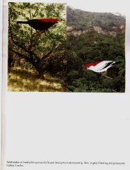
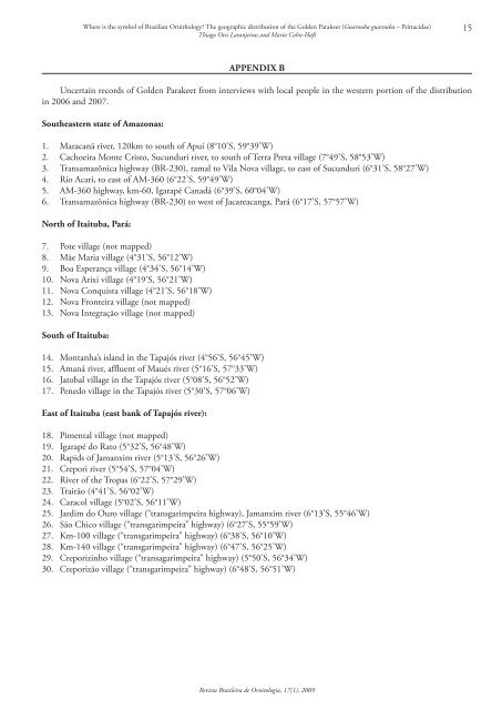
Where is the symbol of Brazilian Ornithology? The geographic distribution of the Gol<strong>de</strong>n Parakeet (Guarouba guarouba – Psittacidae)Thiago Orsi Laranjeiras and Mario Cohn-Haft15APPendix BUncertain records of Gol<strong>de</strong>n Parakeet from interviews with local people in the western portion of the distributionin 2006 and 2007.Southeastern state of Amazonas:1. Maracanã river, 120km to south of Apuí (8°10’S, 59°39’W)2. Cachoeira Monte Cristo, Sucunduri river, to south of Terra Preta village (7°49’S, 58°53’W)3. Transamazônica highway (BR‐230), ramal to Vila Nova village, to east of Sucunduri (6°31’S, 58°27’W)4. Rio Acari, to east of AM‐360 (6°22’S, 59°49’W)5. AM‐360 highway, km‐60, Igarapé Canadá (6°39’S, 60°04’W)6. Transamazônica highway (BR‐230) to west of Jacareacanga, Pará (6°<strong>17</strong>’S, 57°57’W)North of Itaituba, Pará:7. Pote village (not mapped)8. Mãe Maria village (4°31’S, 56°12’W)9. Boa Esperança village (4°34’S, 56°14’W)10. Nova Arixi village (4°19’S, 56°21’W)11. Nova Conquista village (4°21’S, 56°18’W)12. Nova Fronteira village (not mapped)13. Nova Integração village (not mapped)South of Itaituba:14. Montanha’s island in the Tapajós river (4°56’S, 56°45’W)15. Amaná river, affluent of Maués river (5°16’S, 57°33’W)16. Jatobal village in the Tapajós river (5°08’S, 56°52’W)<strong>17</strong>. Penedo village in the Tapajós river (5°30’S, 57°06’W)East of Itaituba (east bank of Tapajós river):18. Pimental village (not mapped)19. Igarapé do Rato (5°32’S, 56°48’W)20. Rapids of Jamanxim river (5°13’S, 56°26’W)21. Crepori river (5°54’S, 57°04’W)22. River of the Tropas (6°22’S, 57°29’W)23. Trairão (4°41’S, 56°02’W)24. Caracol village (5°02’S, 56°11’W)25. Jardim do Ouro village (“transgarimpeira highway), Jamanxim river (6°13’S, 55°46’W)26. São Chico village (“transgarimpeira” highway) (6°27’S, 55°59’W)27. Km‐100 village (“transgarimpeira” highway) (6°38’S, 56°10’W)28. Km‐140 village (“transgarimpeira” highway) (6°47’S, 56°25’W)29. Creporizinho village (“transagarimpeira” highway) (5°50’S, 56°34’W)30. Creporizão village (“transgarimpeira” highway) (6°48’S, 56°51’W)Revista <strong>Brasileira</strong> <strong>de</strong> <strong>Ornitologia</strong>, <strong>17</strong>(1), 2009