Sie wollen auch ein ePaper? Erhöhen Sie die Reichweite Ihrer Titel.
YUMPU macht aus Druck-PDFs automatisch weboptimierte ePaper, die Google liebt.
R1 I Großglockner Tour<br />
Vom Ausgangspunkt dem Tauernradweg bis Bruck folgen.<br />
Danach geht‘s weiter ins Fuschertal. In Fusch beginnt nun<br />
der Anstieg. Die Tour führt vorbei am Wild- & Erlebnispark<br />
Ferleiten bis zur Mautstelle und weiter entlang der aussichtsreichen<br />
Panoramastraße hinauf bis zum höchsten Punkt<br />
der Gebirgsstraße, die Edelweißspitze auf 2.571 m Seehöhe.<br />
Der Rückweg erfolgt über dieselbe Route.<br />
Für Konditionsstarke: Weiterfahrt übers Fuschertörl und dem<br />
Hochtor bis zur Kaiser-Franz-Josefs-Höhe (2.369 m) und/oder<br />
nach Heiligenblut (Kärnten) möglich!<br />
m<br />
3000<br />
Großglockner Hochalpenstraße<br />
2500<br />
2000<br />
1500<br />
1000<br />
500<br />
Asphalt 89,1 km<br />
km 10 20 30 40 50 60 70 80<br />
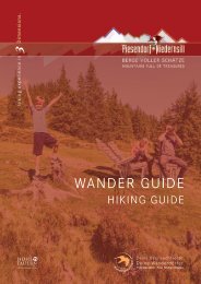
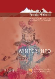
BERGE VOLLER SCHÄTZE<br />
MOUNTAINS FULL OF TREASURES<br />
From the starting point, follow the well-marked Tauern Cycle<br />
Path to Bruck. Then continue into the Fuschertal valley.<br />
The ascent begins in Fusch. Now the tour leads past the wildlife<br />
and adventure park Ferleiten to the toll station and continues<br />
along the panoramic road up to highest point of the high<br />
alpine road, the Edelweißspitze at 2,571 metres above sea level.<br />
The way back is via the same route.<br />
For very fit racing bikers: It is possible to continue via Fuschertörl<br />
and Hochtor to the Kaiser-Franz-Josefs-Höhe (2,369 m)<br />
and/or to Heiligenblut (Kärnten).<br />
89,1 km Start & Ziel:<br />
6:30 h Niedernsill<br />
1.834 m Start & Destination:<br />
1.834 m Niedernsill