Geology of Southern California.pdf - Grossmont College
Geology of Southern California.pdf - Grossmont College
Geology of Southern California.pdf - Grossmont College

Create successful ePaper yourself
Turn your PDF publications into a flip-book with our unique Google optimized e-Paper software.
Sue Monroe<br />
Image courtesy <strong>of</strong> NASA/Earth Observatory<br />
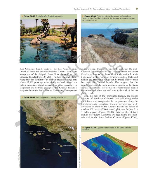
� Figure SC.46 The LaBrea Tar Pits in Los Angeles.<br />
San Clemente Islands south <strong>of</strong> the Los Angeles basin.<br />
North <strong>of</strong> these, the east-west oriented Channel Islands are<br />
comprised <strong>of</strong> San Miguel, Santa Rosa, Santa Cruz, and<br />
Anacapa Islands (Figure SC.47). The four Channel Islands<br />
were united in the form <strong>of</strong> an <strong>of</strong>fshore mountain range until<br />
about 12,000 years ago when rising sea level isolated the<br />
tallest summits as islands separated by ocean passages. The<br />
alignment and bedrock geology <strong>of</strong> the Channel Islands is<br />
very similar to the Santa Monica Mountains, a component<br />
� Figure SC.47 Offshore islands <strong>of</strong> southern <strong>California</strong>.<br />
<strong>Southern</strong> <strong>California</strong>.6 The Transverse Ranges, Offshore Islands, and Interior Basins 27<br />
Dick Hilton<br />
Image courtesy <strong>of</strong> National Oceanographic and Atmospheric Agency<br />
� Figure SC.48 Flat surface in the foreground on Santa Rosa<br />
Island, and on San Miguel Island in the distance, are marine terraces<br />
eroded at sea level.<br />
<strong>of</strong> the western Transverse Ranges. In particular the mid-<br />
Cenozoic volcanic rocks <strong>of</strong> the Channel Islands are almost<br />
identical to those <strong>of</strong> the Santa Monica Mountains. In addition,<br />
many <strong>of</strong> the geological structures such as faults and<br />
folds in the Transverse Ranges can be traced <strong>of</strong>fshore from<br />
land onto the Channel Islands. This suggests that the<br />
islands represent the same mountain system as the Santa<br />
Monica Mountains, except that the westernmost portion<br />
was submerged when sea level rose at the end <strong>of</strong> the last<br />
glacial epoch.<br />
Like the rest <strong>of</strong> the Transverse Ranges, the islands<br />
<strong>of</strong>fshore <strong>of</strong> southern <strong>California</strong> are still rising under<br />
the influence <strong>of</strong> compressive forces generated along the<br />
transform plate boundary. Marine terraces are welldeveloped<br />
on many <strong>of</strong> the Channel Islands and reflect as<br />
much as 600 meters (2000 feet) <strong>of</strong> uplift over the past 2 to<br />
3 million years (Figure SC.48). Between the <strong>of</strong>fshore<br />
islands <strong>of</strong> southern <strong>California</strong> are deep basins and channels<br />
such as the Santa Barbara Channel (Figure SC.49),<br />
� Figure SC.49 Digital elevation model <strong>of</strong> the Santa Barbara<br />
Channel.