Geology of Southern California.pdf - Grossmont College
Geology of Southern California.pdf - Grossmont College
Geology of Southern California.pdf - Grossmont College

You also want an ePaper? Increase the reach of your titles
YUMPU automatically turns print PDFs into web optimized ePapers that Google loves.
6 <strong>Geology</strong> <strong>of</strong> <strong>Southern</strong> <strong>California</strong><br />
<strong>Southern</strong> <strong>California</strong>.2<br />
The Plate Tectonic Framework<br />
<strong>of</strong> <strong>Southern</strong> <strong>California</strong><br />
The geological foundation <strong>of</strong> southern <strong>California</strong> is the<br />
reflection <strong>of</strong> a long and complex plate tectonic history<br />
that is unique with respect to adjacent regions. Positioned<br />
along the leading edge <strong>of</strong> a continent for more than<br />
500 million years, <strong>California</strong> has been affected by several<br />
different kinds <strong>of</strong> plate interactions that have occurred at<br />
the western margin <strong>of</strong> North America. Each shift in the<br />
plate tectonic setting triggered geologic events that contributed<br />
to the complex bedrock geology <strong>of</strong> the region.<br />
The effects <strong>of</strong> the younger tectonic events have become<br />
superimposed on the rocks and structures produced during<br />
earlier episodes <strong>of</strong> geologic activity. The resulting<br />
rock record is a tangled geologic mosaic that has taken<br />
geologists decades to decipher. In fact, there are still<br />
many gaps in our understanding <strong>of</strong> the plate tectonic history<br />
<strong>of</strong> southern <strong>California</strong>, and scientists continue to<br />
explore the region for more evidence that can help<br />
resolve the current uncertainties. Nonetheless, the broad<br />
patterns in the plate tectonic evolution <strong>of</strong> southern<br />
<strong>California</strong> are now fairly well established and provide a<br />
sound basis for understanding the origin <strong>of</strong> this remarkable<br />
landscape.<br />
The rocks <strong>of</strong> southern <strong>California</strong> document almost two<br />
billion years <strong>of</strong> geologic history. In reviewing the major<br />
events in this immense span <strong>of</strong> time, we will utilize the geologic<br />
time scale developed by geologists over the past two<br />
centuries.<br />
Late Precambrian-Paleozoic: Continental Rifting and a<br />
Passive Continental Margin: Near the end <strong>of</strong> Precambrian<br />
time, North America was part <strong>of</strong> a great supercontinent<br />
known as Rodinia. Not to be confused with Pangaea, a<br />
much younger supercontinent, Rodinia had been assembled<br />
by plate convergence from 1.3 to about 1.0 billion years ago.<br />
During the construction <strong>of</strong> Rodinia, the basement rocks<br />
were intensely metamorphosed and deformed by numerous<br />
plate collisions and intruded by magma that crystallized into<br />
plutonic rock. In southern <strong>California</strong>, Precambrian metamorphic<br />
and igneous rocks representing the basement <strong>of</strong><br />
Rodinia occur in the eastern Mojave Desert and in the Basin<br />
and Range province to the north.<br />
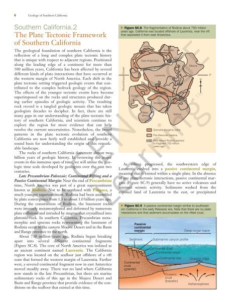
About 750 million years ago, Rodinia began breaking<br />
apart into several different continental fragments<br />
(Figure SC.8). The core <strong>of</strong> North America was isolated as<br />
an ancient continent named Laurentia. The <strong>California</strong><br />
region was located on the seafloor just <strong>of</strong>fshore <strong>of</strong> a rift<br />
zone that formed the western margin <strong>of</strong> Laurentia. Farther<br />
west, a severed continental fragment now in east Antarctica<br />
moved steadily away. There was no land where <strong>California</strong><br />
now stands in the late Precambrian, but there are marine<br />
sedimentary rocks <strong>of</strong> this age in the Mojave Desert and<br />
Basin and Range province that provide evidence <strong>of</strong> the conditions<br />
on the seafloor that existed at this time.<br />
� Figure SC.8 The fragmentation <strong>of</strong> Rodinia about 750 million<br />
years ago. <strong>California</strong> was located <strong>of</strong>fshore <strong>of</strong> Laurentia, near the rift<br />
that separated it from east Antarctica.<br />
Ocean<br />
Mozambique<br />
Kalahari<br />
Congo<br />
India<br />
East Antarctica<br />
West<br />
Africa<br />
Laurentia<br />
Amazonia<br />
Australia<br />
Baltica<br />
Grenville orogenic belts<br />
Pre-Grenville cratons<br />
Rifts where Rodinia started<br />
to fragment 750 million<br />
years ago<br />
Siberia<br />
As rifting progressed, the southwestern edge <strong>of</strong><br />
Laurentia evolved into a passive continental margin,<br />
meaning that it existed within a single plate. In the absence<br />
<strong>of</strong> any plate tectonic interactions, passive continental margins<br />
(Figure SC.9) generally have no active volcanoes and<br />
minimal seismic activity. Sediments washed from the<br />
exposed land <strong>of</strong> Laurentia to the east, or precipitated<br />
� Figure SC.9 A passive continental margin simliar to southeastern<br />
<strong>California</strong> in the early Paleozoic era. Note that there are no plate<br />
interactions and that sediment accumulates on the rifted crust.<br />
Passive<br />
continental<br />
margin Deep-ocean basin<br />
Sediment<br />
Continental<br />
crust<br />
(granitic)<br />
Submarine canyon pr<strong>of</strong>ile<br />
Continental shelf<br />
Continental slope<br />
Continental rise<br />
Oceanic<br />
crust<br />
(basaltic)<br />
N<br />
Oceanic ridge<br />
Asthenosphere<br />
0º