Geology of Southern California.pdf - Grossmont College
Geology of Southern California.pdf - Grossmont College
Geology of Southern California.pdf - Grossmont College

You also want an ePaper? Increase the reach of your titles
YUMPU automatically turns print PDFs into web optimized ePapers that Google loves.
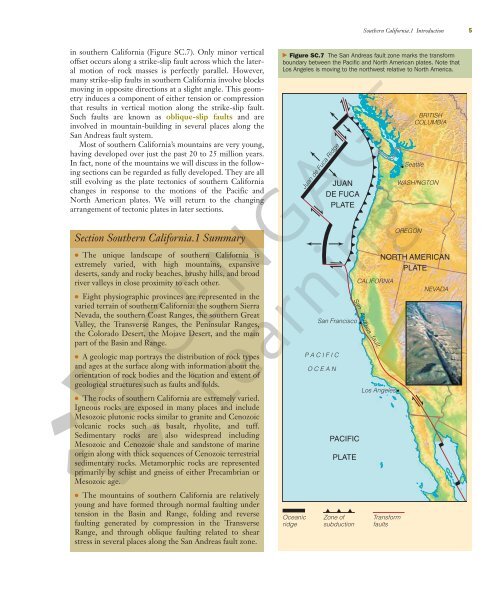
in southern <strong>California</strong> (Figure SC.7). Only minor vertical<br />
<strong>of</strong>fset occurs along a strike-slip fault across which the lateral<br />
motion <strong>of</strong> rock masses is perfectly parallel. However,<br />
many strike-slip faults in southern <strong>California</strong> involve blocks<br />
moving in opposite directions at a slight angle. This geometry<br />
induces a component <strong>of</strong> either tension or compression<br />
that results in vertical motion along the strike-slip fault.<br />
Such faults are known as oblique-slip faults and are<br />
involved in mountain-building in several places along the<br />
San Andreas fault system.<br />
Most <strong>of</strong> southern <strong>California</strong>’s mountains are very young,<br />
having developed over just the past 20 to 25 million years.<br />
In fact, none <strong>of</strong> the mountains we will discuss in the following<br />
sections can be regarded as fully developed. They are all<br />
still evolving as the plate tectonics <strong>of</strong> southern <strong>California</strong><br />
changes in response to the motions <strong>of</strong> the Pacific and<br />
North American plates. We will return to the changing<br />
arrangement <strong>of</strong> tectonic plates in later sections.<br />
Section <strong>Southern</strong> <strong>California</strong>.1 Summary<br />
● The unique landscape <strong>of</strong> southern <strong>California</strong> is<br />
extremely varied, with high mountains, expansive<br />
deserts, sandy and rocky beaches, brushy hills, and broad<br />
river valleys in close proximity to each other.<br />
● Eight physiographic provinces are represented in the<br />
varied terrain <strong>of</strong> southern <strong>California</strong>: the southern Sierra<br />
Nevada, the southern Coast Ranges, the southern Great<br />
Valley, the Transverse Ranges, the Peninsular Ranges,<br />
the Colorado Desert, the Mojave Desert, and the main<br />
part <strong>of</strong> the Basin and Range.<br />
● A geologic map portrays the distribution <strong>of</strong> rock types<br />
and ages at the surface along with information about the<br />
orientation <strong>of</strong> rock bodies and the location and extent <strong>of</strong><br />
geological structures such as faults and folds.<br />
● The rocks <strong>of</strong> southern <strong>California</strong> are extremely varied.<br />
Igneous rocks are exposed in many places and include<br />
Mesozoic plutonic rocks similar to granite and Cenozoic<br />
volcanic rocks such as basalt, rhyolite, and tuff.<br />
Sedimentary rocks are also widespread including<br />
Mesozoic and Cenozoic shale and sandstone <strong>of</strong> marine<br />
origin along with thick sequences <strong>of</strong> Cenozoic terrestrial<br />
sedimentary rocks. Metamorphic rocks are represented<br />
primarily by schist and gneiss <strong>of</strong> either Precambrian or<br />
Mesozoic age.<br />
● The mountains <strong>of</strong> southern <strong>California</strong> are relatively<br />
young and have formed through normal faulting under<br />
tension in the Basin and Range, folding and reverse<br />
faulting generated by compression in the Transverse<br />
Range, and through oblique faulting related to shear<br />
stress in several places along the San Andreas fault zone.<br />
P A C I F I C<br />
O C E A N<br />
P ACIFIC<br />
PLA TE<br />
<strong>Southern</strong> <strong>California</strong>.1 Introduction 5<br />
� Figure SC.7 The San Andreas fault zone marks the transform<br />
boundary between the Pacific and North American plates. Note that<br />
Los Angeles is moving to the northwest relative to North America.<br />
Oceanic<br />
ridge<br />
Juan de Fuca Ridge<br />
JUAN<br />
DE FUCA<br />
PLA TE<br />
San Francisco<br />
Zone <strong>of</strong><br />
subduction<br />
CALIFORNIA<br />
San Andreas fault<br />
Los Angeles<br />
OREGON<br />
BRITISH<br />
COLUMBIA<br />
Seattle<br />
WASHINGTON<br />
NOR TH AMERICAN<br />
PLA TE<br />
Transform<br />
faults<br />
NEVADA