Geology of Southern California.pdf - Grossmont College
Geology of Southern California.pdf - Grossmont College
Geology of Southern California.pdf - Grossmont College

Create successful ePaper yourself
Turn your PDF publications into a flip-book with our unique Google optimized e-Paper software.
36 <strong>Geology</strong> <strong>of</strong> <strong>Southern</strong> <strong>California</strong><br />
<strong>Southern</strong> <strong>California</strong>.9<br />
<strong>Southern</strong> <strong>California</strong> Earthquakes<br />
Earthquakes in <strong>California</strong> are an inevitable consequence <strong>of</strong><br />
the interactions between tectonic plates along the forward<br />
edge <strong>of</strong> a west-moving continent. The forces generated<br />
along the transform boundary between the Pacific and<br />
North American plates result in thousands <strong>of</strong> earthquakes<br />
every year. The ground literally shakes continuously in<br />
<strong>California</strong>, but most <strong>of</strong> these tremors go unfelt by people<br />
and rarely cause damage. Nonetheless, the seismic history<br />
<strong>of</strong> southern <strong>California</strong> includes some devastating events<br />
that serve as reminders <strong>of</strong> the serious hazards facing those<br />
who live near such as active plate boundary.<br />
Historic and Ancient Earthquakes in <strong>Southern</strong><br />
<strong>California</strong>: Though earthquakes occur in many parts <strong>of</strong><br />
<strong>California</strong>, exceptionally powerful temblors have repeatedly<br />
shaken the southern part <strong>of</strong> the state. The 1857 Fort Tejon<br />
earthquake and the Lone Pine earthquake <strong>of</strong> 1873 rank<br />
among the greatest seismic events in <strong>California</strong> history.<br />
The Fort Tejon earthquake (estimated magnitude 7.9)<br />
resulted from a sudden slip along more than 300 kilometers<br />
(180 miles) <strong>of</strong> the San Andreas fault from the Transverse<br />
Ranges area to the central Coast Ranges. Effects <strong>of</strong> this<br />
earthquake were widespread and included uprooted trees,<br />
damaged building, and disrupted stream drainages, and<br />
liquefaction. Only the sparse human population at the<br />
time limited the death toll to one. The Lone Pine earthquake<br />
was more tragic. At least 23 people died when the<br />
magnitude 7.8 quake toppled most <strong>of</strong> the adobe brick<br />
buildings the eastern Sierra Nevada town. The Lone Pine<br />
event resulted from slip along the normal fault zone at the<br />
base <strong>of</strong> the Sierra Nevada, and thus occurred in a completely<br />
different plate tectonic setting as the Fort Tejon shock.<br />
The scarp, or surface exposure, <strong>of</strong> this normal fault is still<br />
visible in the hills just west <strong>of</strong> Lone Pine (Figure SC.19).<br />
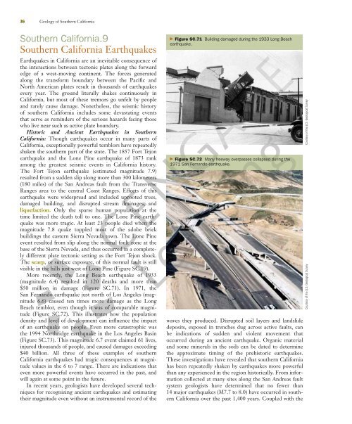
More recently, the Long Beach earthquake <strong>of</strong> 1933<br />
(magnitude 6.4) resulted in 120 deaths and more than<br />
$50 million in damage (Figure SC.71). In 1971, the<br />
San Fernando earthquake just north <strong>of</strong> Los Angeles (magnitude<br />
6.6) caused ten times more damage as the Long<br />
Beach temblor, even though it was <strong>of</strong> comparable magnitude<br />
(Figure SC.72). This illustrates how the population<br />
density and level <strong>of</strong> development can influence the impact<br />
<strong>of</strong> an earthquake on people. Even more catastrophic was<br />
the 1994 Northridge earthquake in the Los Angeles Basin<br />
(Figure SC.73). This magnitude 6.7 event claimed 61 lives,<br />
injured thousands <strong>of</strong> people, and caused damages exceeding<br />
$40 billion. All three <strong>of</strong> these examples <strong>of</strong> southern<br />
<strong>California</strong> earthquakes had tragic consequences at magnitude<br />
values in the 6 to 7 range. There are indications that<br />
even more powerful events have occurred in the past, and<br />
will again at some point in the future.<br />
In recent years, geologists have developed several techniques<br />
for recognizing ancient earthquakes and estimating<br />
their magnitude even without an instrumental record <strong>of</strong> the<br />
� Figure SC.71 Building damaged during the 1933 Long Beach<br />
earthquake.<br />
� Figure SC.72 Many freeway overpasses collapsed during the<br />
1971 San Fernando earthquake.<br />
waves they produced. Disrupted soil layers and landslide<br />
deposits, exposed in trenches dug across active faults, can<br />
be indications <strong>of</strong> sudden and violent movement that<br />
occurred during an ancient earthquake. Organic material<br />
and some minerals in the soils can be dated to determine<br />
the approximate timing <strong>of</strong> the prehistoric earthquakes.<br />
These investigations have revealed that southern <strong>California</strong><br />
has been repeatedly shaken by earthquakes more powerful<br />
than any experienced in the region historically. From information<br />
collected at many sites along the San Andreas fault<br />
system geologists have determined that no fewer than<br />
14 major earthquakes (M7.7 to 8.0) have occurred in southern<br />
<strong>California</strong> over the past 1,400 years. Coupled with the<br />
Courtesy <strong>of</strong> the U.S. Geological Survey<br />
Courtesy <strong>of</strong> the U.S. Geological Survey