MAPS OF NEWFOUNDLAND - McMaster University
MAPS OF NEWFOUNDLAND - McMaster University
MAPS OF NEWFOUNDLAND - McMaster University

You also want an ePaper? Increase the reach of your titles
YUMPU automatically turns print PDFs into web optimized ePapers that Google loves.
180 EARLY PRINTED <strong>MAPS</strong> <strong>OF</strong> CANADA<br />
ENTRY 544. ROBERT SAYER. 1788. Third<br />
state.<br />
Map title: A CHART / <strong>OF</strong> THE SOUTH-EAST<br />
PART / <strong>OF</strong> / <strong>NEWFOUNDLAND</strong>, / —<br />
Map size: 49.9 x 68 cm.<br />
Published in: The North American Pilot for<br />
Newfoundland, Labradore, the Gulf and River<br />
St. Laurence — London Sayer and Bennett 1784<br />
and in: The North American Pilot — 1794LC<br />
G1106 .P5N6 1784[1788] Vault; NMC G 1106<br />
.P5N6 1794 fol Vault.<br />
Ref: LC Phillips 10325.<br />
Top right corner, outside the neat-line, is “ III ” and<br />
bottom centre “ London. Printed for R. Sayer, Map<br />
& Chartfeller, N o . 53 in Fleet Street. Street .<br />
10 th .Feb y .1788.” The repetition presumably is the<br />
result of inaccurate erasing of the previous imprint!<br />
ENTRY 545. LAURIE & WHITTLE.<br />
[1794]1799, 1806. Fourth state.<br />
Plate: 392.<br />
Map title: A CHART / <strong>OF</strong> THE SOUTH-EAST<br />
PART / <strong>OF</strong> / <strong>NEWFOUNDLAND</strong>, / —<br />
Map size: 50 x 68 cm.<br />
Published in: The First part of the North<br />
American Pilot —1799, 1806.<br />
LC G1106 .P5N6 1799, 1806 Vault.<br />
Ref: LC Phillips 1236, 4476.<br />
Engraved below the border is “ Publifhed 12 May<br />
1794 . by LAURIE & WHITTLE, N o . 53 Fleet<br />
Street London.”.<br />
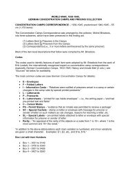
Plate 392. Chart of the Avalon peninsula which appeared as a number of states dated 1770,<br />
1777, 1788 & 1794. This is the final state with a Laurie & Whittle imprint but apparently no<br />
other changes. Entry 545. ( Courtesy of the National Archives of Canada ).