THE SIEGE OF QUEBEC - McMaster University
THE SIEGE OF QUEBEC - McMaster University
THE SIEGE OF QUEBEC - McMaster University

Create successful ePaper yourself
Turn your PDF publications into a flip-book with our unique Google optimized e-Paper software.
<strong>QUEBEC</strong> CITY & PROVINCE, <strong>SIEGE</strong> <strong>OF</strong> <strong>QUEBEC</strong>, MONTREAL, WEST COAST AND ADMIRAL DE FONTE 15<br />
CHAPTER TWO<br />
<strong>THE</strong> <strong>SIEGE</strong> <strong>OF</strong> <strong>QUEBEC</strong><br />
Champlain's choice of location for Quebec City was based both on its defensive potential and its<br />
commanding control of the river below. Brigadier General Wolfe quickly appreciated this after a<br />
number of abortive efforts to mount an attack. Notably, his attempt to breach the defences at<br />
Montmorency was an abysmal failure. With lack of success and with Wolfe in poor health, he could do<br />
little but mount a continuous bombardment of the city, reducing it largely to rubble. In addition,<br />
punitive destruction of villages and farms along the river served little other than to salve military<br />
frustration.<br />
By the end of the summer and with winter approaching, Wolfe was at variance with his officers<br />
and was considering a general withdrawal. He was, however, urged to make a final attempt with an<br />
audacious scheme to land troops, who would then scale the cliffs leading up to the Plains of Abraham.<br />
The British troops were highly disciplined and with professional training, and in a direct confrontational<br />
mode were potentially far superior to the French forces which had been heavily reinforced with civilian<br />
forces. Weighed against this was the highly exposed position of the British troops with a difficult<br />
retreat line, and with French forces upriver at Montreal. However, the plan succeeded and Montcalm<br />
obviously thought he could defeat the British, and made the mistake of moving against them in ordered<br />
formation. The close range musket volleys from the disciplined British troops were devastating and<br />
the battle only lasted some fifteen minutes.<br />
The news of the victory was received in England and America with great enthusiasm and resulted<br />
in numerous accounts and plans of the battle formations. Of particular interest is the duplication of a<br />
number of these maps, which at first sight appear identical, but in fact on close inspection show that<br />
they were carefully copied, but apparently published in the same run of a monthly magazine. Presumably<br />
intense interest in accounts of the the siege led to the requirement of additional copies of the magazine,<br />
sometimes when production had already commenced on copy for the next months issue, when some<br />
plates had already been reworked. As a result new plates had then to be re-engraved, closely copied<br />
from the originals, to allow the run on monthly sales to be satisfied. Examples of these duplicated<br />
plates can be seen in the Grand Magazine of Universal Intelligence, Oct. 1759; Gentlemans<br />
Magazine, November 1759, and in the London Magazine October 1760 where the view of Montreal<br />
is duplicated. ( see Entries 1020, 1024, 1092 & 1093 ).
16 EARLY PRINTED MAPS <strong>OF</strong> CANADA IV.<br />
ENTRY VANDER AA. Second state. 1729.<br />
Map title: Quebec<br />
Ref: Kershaw v.1, p. 250, ENTR Y 281, Plate 185.<br />
ENTRY 1015. JEFFERYS. 1759. First state.<br />
Plate: 775.<br />
Map title: A CORRECT PLAN / <strong>OF</strong> <strong>THE</strong> /<br />
ENVIRONS <strong>OF</strong> <strong>QUEBEC</strong>, / AND <strong>OF</strong> <strong>THE</strong> /<br />
BATTLE fought on the 13 th . September, 1759: /<br />
Together with a particular Detail of / — / Engraved<br />
by THOMAS JEFFERYS, / Geographer to His<br />
MAJESTY.<br />
Map size: 40.9 x 88.7 cm.<br />
Published in: A General Topography of North<br />
America —. London For R. Sayer & T. Jefferys 1768.<br />
LC G 1105 .J4 1768 Vault; G3454 .Q4 1759 .J<br />
Vault; BN du Q G3452 Q4 R1 1762 4H d; NMC<br />
21042, 54105.<br />
Ref: BN du Q # 948.<br />
Engraved outside the neat-line, bottom left, is<br />
“ Published According to Act of Parliament by<br />
Thos. Jefferys, the Corner of S t . Martins Lane<br />
Charing Crofs.”. There is an engraved portion<br />
pasted over at the left-hand side, just north of<br />
“ADMIRAL HOLMES’s DIVISION ”, showing the<br />
changed battle lines on the Plains of Abraham with<br />
the English boats landing troops.<br />
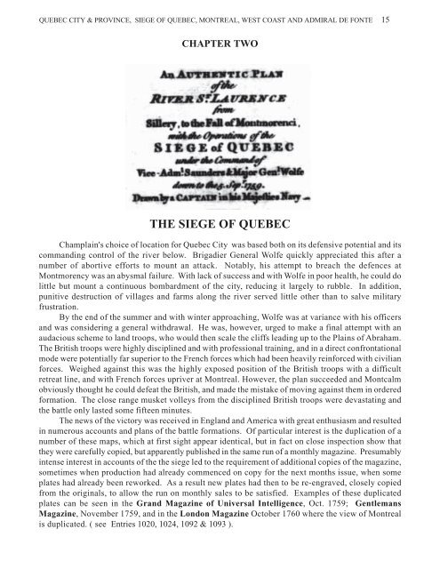
ENTRY 1016. JEFFERYS. 1759. First state.<br />
Map title: An AU<strong>THE</strong>NTIC PLAN / of the /<br />
RIVER S T . LAURENCE / from / Sillery, to the Fall<br />
of Montmorenci, / with the Operations of the /<br />
<strong>SIEGE</strong> of <strong>QUEBEC</strong> / under the Command of /<br />
Vice-Adm l . Saunders &Major Gen l . Wolfe / down<br />
to the 5.Sep r . 1759 / Drawn by a CAPTAIN in his<br />
Majefties Navy
<strong>QUEBEC</strong> CITY & PROVINCE, <strong>SIEGE</strong> <strong>OF</strong> <strong>QUEBEC</strong>, MONTREAL, WEST COAST AND ADMIRAL DE FONTE 17<br />
Map size: 33 x 47.7 cm.<br />
Published in: The Natural and Civil History of<br />
the French Dominions ——. London 1760. p131.<br />
Ref: Armstrong 1982, # 26; BN du Q #.<br />
National Library of Canada FC 305 J 44 x fol RES. ;<br />
BN du Q RES AB 5; NMC 2716, 15644.<br />
There is a dedication to William Pitt engraved in the<br />
top left corner, and outside the neat-line, bottom right,<br />
is “ Price 2 d ”.<br />
ENTRY 1017. JEFFERYS. 1759. Second state.<br />
Plate: 776.<br />
Map title: An AU<strong>THE</strong>NTIC PLAN / of the /<br />
RIVER S T . LAURENCE / from / Sillery, to the Fall<br />
of Montmorenci, / with the Operations of the /<br />
<strong>SIEGE</strong> of <strong>QUEBEC</strong> / under the Command of /<br />
Vice-Adm l . Saunders &Major Gen l . Wolfe / down<br />
to the 5.Sep r . 1759 / Drawn by a CAPTAIN in his<br />
Majefties Navy<br />
Map size: 33 x 47.7 cm.<br />
Published in: A General Topography of North<br />
America. London 1768.<br />
NMC 97969, 97970; LC G 1105 .J4 1768 Vault.<br />
There is a dedication to William Pitt engraved in the<br />
top left corner, and outside the neat-line, bottom right,<br />
is “ Published by Tho s .Jefferys Geographer to his<br />
Royal Highnefs the Prince of Wales. near Charing<br />
Crofs, London. Price 2 d ”.<br />
ENTRY 1018. TIRION. 1759.<br />
Plate: 777.<br />
Map title: QUEBEK, / De Hoofdstad van /<br />
KANADA; / aan de Rivier van S t . Laurens: / door<br />
de Engelschen belegerd en by Verdrag demagtigd,<br />
/ in’t jaar 1759.<br />
Map size: 32.6 x 42.7 cm.<br />
Published in: Nieuwe en beknopte Hand-Atlas, --.<br />
Amsterdam 1769.<br />
And in: Hedendaagsche Historie of<br />
Tegenwordige Staat van Amerika. Amsterdam, I.<br />
Tirion 1769.<br />
NMC 2720; LC G1015 .T5 1769; BN du Q G 3452<br />
Q4R1 1759 T5.<br />
Ref: BN du Q # 1552; LC Phillips 600.<br />
ENTRY 1019. GRAND MAGAZINE <strong>OF</strong><br />
UNIVERSAL INTELLIGENCE. 1759.<br />
Plate: 778.<br />
Map title: A MAP / of the Country round /<br />
<strong>QUEBEC</strong>, / with the Camps of the / Englifh &<br />
French, at the Siege thereof. / 1759.<br />
Map size: 16.4 x 22.5 cm.<br />
Published in: Grand Magazine of Universal<br />
Intelligence. v.2, Oct. 1759, p.553.<br />
NMC 2719; BN du Q G 3452 Q4R1 1759 G7.<br />
Ref: Jolly GMUI-14; BN du Q # 795.<br />
Engraved in the top margin is “ Engraved for the<br />
Grand Mag. Printed for R. Griffiths London.”.<br />
Plate 775. Jefferys beautifully engraved map<br />
of the siege, published in A General<br />
Topography of North America. There is a slip<br />
of printed paper pasted over the map at the left<br />
so that both the initial battle formations and the<br />
secondary battle lines are shown. Details of<br />
these are shown overleaf. Entry 1015.<br />
( Courtesy of the Library of Congress ).
18 EARLY PRINTED MAPS <strong>OF</strong> CANADA IV.
<strong>QUEBEC</strong> CITY & PROVINCE, <strong>SIEGE</strong> <strong>OF</strong> <strong>QUEBEC</strong>, MONTREAL, WEST COAST AND ADMIRAL DE FONTE 19<br />
Plate 776. Jefferys second plan of the siege , published in A General Topography of North America<br />
in 1768. Entry 1017. ( Courtesy of the National Archives of Canada )<br />
Plate 777. Tirion's plan of the siege, closely copied from Jefferys and published later. Entry 1018.<br />
( Courtesy of the National Archives of Canada )
20 EARLY PRINTED MAPS <strong>OF</strong> CANADA IV.<br />
ENTRY 1020. GRAND MAGAZINE <strong>OF</strong><br />
UNIVERSAL INTELLIGENCE. ? 1759.<br />
Plate: 779.<br />
Map title: A MAP / of the Country round /<br />
<strong>QUEBEC</strong>, / with the Camps of the / Englifh &<br />
French, at the Siege thereof. / 1759.<br />
Map size: 16.2 x 21.9 cm.<br />
Published in: Grand Magazine of Universal<br />
Intelligence. v.2. Oct. 1759. opp. p. 552.<br />
NMC 84683.<br />
Ref: Jolly GMUI-14.<br />
A close copy of the equivalent map in the Grand<br />
Magazine 1759 (Entry 1019), possibly in<br />
response to additional copies being required. The<br />
plate is entirely re-engraved and completely lacks<br />
the running title above the neat-line<br />
ENTRY 1021. SCOTS MAGAZINE. 1759.<br />
Plate: 780.<br />
Map title: A Plan of the operations / at the<br />
taking of <strong>QUEBEC</strong>, / and the Battle fought near<br />
/ that City, Sept r 13. 1759.<br />
Map size: 11.4 x 18.7 cm.<br />
Published in: Scots Magazine. v. 21, Oct. 1759,<br />
p.552.<br />
BN du Q G 3452 Q4R1 1759 P5.<br />
Ref: Phillips Maps p.734; BN du Q # 1002; Jolly<br />
SCOT-25.<br />
“ T Phinn Sc, ” is engraved bottom right, inside<br />
the neat-line.<br />
Plate 778. Plan of the siege, published in the Grand Magazine of Universal Intelligence in<br />
Oct 1759. Entry 1019. ( Courtesy of the National Archives of Canada )
<strong>QUEBEC</strong> CITY & PROVINCE, <strong>SIEGE</strong> <strong>OF</strong> <strong>QUEBEC</strong>, MONTREAL, WEST COAST AND ADMIRAL DE FONTE 21<br />
Plate 779. Plan of the siege, possibly published in the Grand Magazine of Universal Intelligence in<br />
Oct 1759, as a second edition in response to heavy demand for the magazine . Entry 1020.<br />
ENTRY 1022. GRAND MAGAZINE <strong>OF</strong><br />
MAGAZINES. 1759.<br />
Plate: 781.<br />
Map title: A PLAN / of the / Seat of War / at<br />
and near / <strong>QUEBEC</strong>, / with the Line of Battle.<br />
Map size: 11.4 x 18.7 cm.<br />
Published in: Grand Magazine of Magazines.<br />
v.3, Oct. 1759, p.273.<br />
Ref: Jolly GMOM-33.<br />
Engraved at the lower left, inside the neat-line is<br />
“ J. Gibson Sculp.”.<br />
ENTRY 1023. GENTLEMANS & LONDON<br />
MAGAZINE. 1759.<br />
Plate: 782.<br />
Map title: A PLAN / of the / Seat of War / at<br />
and near / <strong>QUEBEC</strong> / with the Line of Battle<br />
( Courtesy of the National Archives of Canada )<br />
Map size: 11.2 x 18.3 cm.<br />
Published in: Gentlemans & London Magazine<br />
v. 28, Nov. 1759, p. 556.<br />
Ref: Jolly GAL-76.<br />
ENTRY 1024. GENTLEMANS MAGAZINE.<br />
1759. ( Probably the first issue )<br />
Plate: 783. ( 784 )<br />
Map title: An AU<strong>THE</strong>NTIC PLAN / of the /<br />
RIVER S T .LAURENCE, / from SILLERY to the<br />
/ FALLS of MONTMORENCY.<br />
Map size: 10.6 x 18.6 cm.<br />
Published in: Gentlemans Magazine. v.29, Nov<br />
1759, p.8.<br />
BN du Q G 3452 Q4R1 1759 G5.<br />
Ref: Michigan v.1, p.50; BN du Q # 623, # 773;<br />
Jolly GENT-137; Clements v. 3, p. 100.<br />
“ J Gibson Sculp t . ” is engraved outside the neatline,<br />
lower right.
22 EARLY PRINTED MAPS <strong>OF</strong> CANADA IV.<br />
ENTRY 1025. GENTLEMANS MAGAZINE.<br />
1759. ( Probably the second issue. )<br />
Plate: 784.<br />
Map title: An AU<strong>THE</strong>NTIC PLAN / of the /<br />
RIVER S T . LAURENCE, / from SILLERY to<br />
the / FALLS of MONTMORENCY.<br />
Map size: 10.6 x 18.6 cm.<br />
Published in: Gentlemans Magazine. v. 29, Nov<br />
1759, p. 8.<br />
BN du Q G3452 Q4R1 1759.<br />
Ref: Jolly GENT-137; BN du Q #773.<br />
“ J Gibson Sculp t . ” is engraved outside the neatline,<br />
lower right. However, the entire plate has<br />
been re-engraved. This may have resulted from<br />
heavy demand for this particular edition of the<br />
Magazine and the requirement for a second<br />
printing after some of the plates had already been<br />
reworked for the next Magazine edition.<br />
ENTRY 1026. LONDON MAGAZINE. 1759.<br />
Plate: 785.<br />
Map title: A PLAN of the / RIVER S T .<br />
LAWRENCE, / from the / Falls of Montmorenci<br />
to Sillery; / with the Operations of the / <strong>SIEGE</strong><br />
of <strong>QUEBEC</strong>.<br />
Map size: 17.8 x 25.4 cm.<br />
Published in: London Magazine. v. 28, Nov.<br />
1759, p. 608; & in An Accurate and Authentic<br />
Journal of the Siege of Quebec. London 1759<br />
NMC 2725; BN du Q RES AE 154; Clements<br />
Library C 1759 Ac.<br />
Ref: Michigan v.2, p.259; Phillips Maps p.734;<br />
Winsor v.5, p.542. Jolly LOND-178; BN du Q # 977.<br />
Engraved above the neat-line is “ For the London<br />
Mag. ”.<br />
Plate 780. Plan of the siege, published in the Scots Magazine in Oct 1759. Entry 1021.<br />
( Courtesy of the Bibliothèque Nationale du Quebec ).
<strong>QUEBEC</strong> CITY & PROVINCE, <strong>SIEGE</strong> <strong>OF</strong> <strong>QUEBEC</strong>, MONTREAL, WEST COAST AND ADMIRAL DE FONTE 23<br />
Plate 781. Plan of the siege, published in the Grand Magazine of Magazines in Oct 1759.<br />
Entry 1022.<br />
Plate 782. Plan of the siege, published in the Gentlemans & London Magazine in Nov 1759.<br />
Entry 1023.
24 EARLY PRINTED MAPS <strong>OF</strong> CANADA IV.<br />
Plate 783. Plan of the siege, published in the Gentlemans Magazine in Nov. 1759. Entry 1024.<br />
This is probably the first issue of the plate. Comparative details of both issues are given below.<br />
Entry 1024-1025.<br />
( Courtesy of the Bibliothèque Nationale du Quebec ).<br />
Plate 784. It is evident from the layout of the lettering and its exact configuration that indeed the<br />
whole plate was re-engraved. The slightly improved layout of the lettering “ within Musquet Shot ”,<br />
adjacent to the Montmorency River and Falls, is used to identify the second issue.
<strong>QUEBEC</strong> CITY & PROVINCE, <strong>SIEGE</strong> <strong>OF</strong> <strong>QUEBEC</strong>, MONTREAL, WEST COAST AND ADMIRAL DE FONTE 25<br />
Plate 785. Plan of the siege, published in the London Magazine in Nov.1759. Entry 1026.<br />
ENTRY 1027. UNIVERSAL MAGAZINE. 1759.<br />
Plate: 786.<br />
Map title: An / Authentic PLAN of the / RIVER S T .<br />
LAURENCE, / from Sillery to the Fall of<br />
Montmorenci; / with the Operations of the / <strong>SIEGE</strong><br />
of <strong>QUEBEC</strong>, / under the Command of / Vice-Adm l .<br />
Saunders & Major Gen l . Wolfe. / 1759.<br />
Map size: 29.8 x 35.6 cm.<br />
Published in: Universal Magazine. v. 25, Dec.<br />
1759, p. 281.<br />
NMC 2722.<br />
Ref: Phillips Maps p.732; Jolly UNIV-85.<br />
There are two insets: “ Part of the Upper River of<br />
St. Laurence ” & “ A View of the ACTION gained<br />
by the ENGLISH near <strong>QUEBEC</strong>, Sep r . 13. 1759. ”.<br />
( Courtesy of the National Archives of Canada ).<br />
ENTRY 1028. ROYAL MAGAZINE. 1759.<br />
Plate: 787.<br />
Map title: An Authentic Plan / of the / RIVER<br />
S T . LAURENCE, / from / Sillery to the Fall of<br />
Montmerenci. / with the Operations of the /<br />
<strong>SIEGE</strong> of <strong>QUEBEC</strong>, / under the Command of<br />
/ Vice-Adm l . Saunders & Maj r . Gen l . Wolfe /<br />
down to the 5 Sep r . 1759. / Drawn by a<br />
CAPTAIN in his / Majesties Navy.<br />
Map size: 18.5 x 24.1 cm.<br />
Published in: Royal Magazine. v.1, Dec 1759,<br />
p.279; & in A Letter to the Right Honourable<br />
William Pitt —. London 1759; & in: Brittania<br />
Triumphant —. London 1777.<br />
Clements Library C 1759 Le, C 1777 Br ; LC<br />
Rare Books AP3.R7.<br />
Ref: Michigan v.1, p.50; Jolly ROYMAG-6;<br />
Trudel 1973, #64; Clements v. 3, p. 100.<br />
Engraved above the neat-line, top right is “ Royal<br />
Mag. ”.
26 EARLY PRINTED MAPS <strong>OF</strong> CANADA IV.<br />
Plate 786. Plan of the siege, published in the Universal Magazine in Dec 1759.<br />
Entry 1027. ( Courtesy of the National Archives of Canada ).<br />
ENTRY 1029. NEW YORK GAZETTE 1759.<br />
Plate: 788.<br />
Map title: A Plan of the CITY of <strong>QUEBEC</strong>K.<br />
Map size: 7.5 x 13.2 cm.<br />
Published in: The American Country Almanac<br />
for 1760.<br />
Clements v.3, p.125; Wheat & Brun # 84; Winsor<br />
v.5, p.543.<br />
ENTRY 1030. WEA<strong>THE</strong>RWISE 1761<br />
Plate: 789.<br />
Map title: PLAN of the CITY of <strong>QUEBEC</strong>K<br />
Map size: 8 x 13 cm.<br />
Published in: Father Abrahams Almanac — for<br />
the year 1761. Philadelphia 1761.<br />
BN du Q RES AF 182.<br />
Ref: BN du Q # 605.<br />
ENTRY 1031. TOBLER 1761.<br />
Plate: 790.<br />
Map title: no title<br />
Map size: 13.4 x 19.4 cm.<br />
Published in: Pennsylvania Town and Countrymans<br />
Almanack for —1761—. Germantown 1761<br />
Ref: Clements v.3, p.128.<br />
ENTRY 1032. SAUR 1762.<br />
Plate: 791.<br />
Map title: no title<br />
Map size: 13.4 x 19.4 cm.<br />
Published in: Deutch Americanisch Calender<br />
auf —1762—. Germantown 1762.<br />
The same woodblock appears to have been used<br />
from the Tobler edition, but with different text<br />
added.
<strong>QUEBEC</strong> CITY & PROVINCE, <strong>SIEGE</strong> <strong>OF</strong> <strong>QUEBEC</strong>, MONTREAL, WEST COAST AND ADMIRAL DE FONTE 27<br />
Plate 787. Plan of the siege, published in the Royal Magazine in Dec 1759.<br />
Entry 1028. ( Courtesy of the National Archives of Canada ).<br />
ENTRY 1033. GENTLEMANS & LONDON<br />
MAGAZINE. 1760.<br />
Plate: 792.<br />
Map title: A PLAN of the / RIVER S T .<br />
LAWRENCE, / from the / Falls of Montmorenci<br />
to Sillery; / with the Operations of the / <strong>SIEGE</strong><br />
of <strong>QUEBEC</strong>.<br />
Map size: 17.6 x 24 cm.<br />
Published in: Gentlemans & London Magazine.<br />
v.29, Jan. 1760, p.20; & in The History of the<br />
Late War —- . Dodsley, Dublin Reprinted by John<br />
Exshaw —<br />
NMC 16089; BN du Q RES 154.<br />
Ref: BN du Q # 1005; Jolly GAL-79.<br />
Engraved in the lower margin at the left is “ D.<br />
Pomarede Sc t . ”.<br />
ENTRY 1034. ANON. ca. 1760<br />
Plate: 793.<br />
Map title: A PLAN / of the Operations at taking<br />
of the / CITY of <strong>QUEBEC</strong><br />
Map size: 13.4 x 18.3 cm.<br />
NMC 15682.<br />
Engraved along the bottom of the map is “ Sold by<br />
And. w Bell & Comp y Engravers Parliament Clofs<br />
Edin: r price 3 d . ”.
28 EARLY PRINTED MAPS <strong>OF</strong> CANADA IV.<br />
Plate 788. Plan of the siege, published in the New York Gazette in 1760. Entry 1029.<br />
( Courtesy of the Clements Library ).<br />
Plate 789. Plan of the siege, published in Father Abrahams Almanac in 1761. Entry 1030.<br />
( Courtesy of the Clements Library ).
<strong>QUEBEC</strong> CITY & PROVINCE, <strong>SIEGE</strong> <strong>OF</strong> <strong>QUEBEC</strong>, MONTREAL, WEST COAST AND ADMIRAL DE FONTE 29<br />
Plate 790. Plan of the siege, published in Pennsylvania Town & Countrymans Almanack 1761.<br />
Entry 1031. ( Courtesy of the Clements Library ).<br />
Plate 791. Plan of the siege, published in Deutch Americanisch Calender 1762.<br />
Entry 1032. ( Courtesy of the Clements Library ).
30 EARLY PRINTED MAPS <strong>OF</strong> CANADA IV.<br />
Plate 792. Plan of the siege, published in the Gentlemans & London Magazine in Jan 1760.<br />
Entry 1033. ( Courtesy of the National Archives of Canada ).<br />
Plate 793. Plan of the siege, published ca.1760. Entry 1034.<br />
( Courtesy of the National Archives of Canada ).
<strong>QUEBEC</strong> CITY & PROVINCE, <strong>SIEGE</strong> <strong>OF</strong> <strong>QUEBEC</strong>, MONTREAL, WEST COAST AND ADMIRAL DE FONTE 31<br />
ENTRY 1035. CHRETIEN FREDERIC DE<br />
HEYDEN-KILIAN 1760.<br />
Plate: 794.<br />
Map title: Englifche / EROBERUNG von / QUE-<br />
BEC den 18. Sept 1759. / ——<br />
Map size: 17.8 x 18.2 cm.<br />
Published in: Theatre de Guerre.<br />
NMC 25972; Clements Library.<br />
Ref: Clements v.3, p.135.<br />
“ XVII ” is engraved top right.<br />
ENTRY 1036. CHRETIEN FREDERIC DE<br />
HEYDEN-KILIAN 1761.<br />
Plate: 795.<br />
Map title: BATAILLE / so / den 28. April Ao.<br />
1760. / zwifchen den Englifchen Trouppen /<br />
unter Comando / des General Murray / — /<br />
unter Comando des Marquis Vaudreuil / —-<br />
Map size: 17.8 x 18.2 cm.<br />
Published in: Theatre de Guerre.<br />
NMC 25973; Clements Library.<br />
Ref: Clements v.3, p. 135<br />
“ XXIV ” is engraved top left.<br />
Plate 794. Plan of the siege, published by<br />
Kilian in 1760.<br />
Entry 1035. ( Courtesy of the Clements Library).<br />
ENTRY 1037. CHRETIEN FREDERIC DE<br />
HEYDEN-KILIAN 1760.<br />
Plate: 796.<br />
Map title: Belagerung / der / Stadt <strong>QUEBEC</strong>/ —<br />
Map size: 17.4 x 16.4 cm.<br />
Published in: Theatre de Guerre.<br />
NMC 25973; Clements Library.<br />
Ref: Clements v.3, p. 135.<br />
“ XXV ” is engraved top left.<br />
ENTRY 1038. ENTICK-OGDEN. 1763.<br />
Plate: 797.<br />
Map title: A New and Accurate Plan of the<br />
RIVER S T . LAWRENCE, from the Falls of /<br />
Montmorenci to Sillery; with the Operations of<br />
the <strong>SIEGE</strong> of <strong>QUEBEC</strong>.1763.<br />
Map size: 17.2 x 23.6 cm.<br />
Published in: The General History of the Late<br />
War —. London M.DCC.LXIII; & in: The<br />
British Lion Rous’d —- . Manchester 1762<br />
BN du Q RES AE 42; Clements Library C2 1762 Og.<br />
Ref: BN du Q #697.<br />
Plate 795. Plan of the siege, published by<br />
Kilian in 1761.<br />
Entry 1036. ( Courtesy of the Clements Library).
32 EARLY PRINTED MAPS <strong>OF</strong> CANADA IV.<br />
Plate 796. Plan of the siege, published by<br />
Kilian in 1760.<br />
Entry 1037. ( Courtesy of the Clements Library).<br />
ENTRY 1039. BEAURAIN. 1765.<br />
Plate: 798.<br />
Map title: BATAILLE sous / <strong>QUEBEC</strong> dans le<br />
/ Canada——<br />
Map size: 8.2 x 12.6 cm.<br />
Published in: Guerre de 1755 à 1763 —. Paris<br />
1765.<br />
LC Phillips 2813, G1793 .B3 1765 Vault.<br />
ENTRY 1040. MANTE. 1772.<br />
Plate: 799.<br />
Map title: ATTACK on <strong>QUEBEC</strong>. The FLEET<br />
Commanded by ADMIRAL SAUNDERS. The<br />
ARMY by MAJOR GENERAL WOLFE.<br />
Map size: 40.5 x 87.4 cm.<br />
Published in: The History of the Late War in<br />
North America..... By Thomas Mante...London<br />
... MDCCLXXII.<br />
BN Ge FF 8726; National Library of Canada E<br />
199.M29; LC E199. M29.<br />
Engraved in the top left corner, outside the neatline,<br />
is “ Facing page 233 ”, and in the top right<br />
corner, outside the neat-line, is “ Engrav’d for Mr .<br />
Mant’s History of the War in America ”.<br />
ENTRY 1041. FADEN. 1776.<br />
Plate: 800.<br />
Map title: PLAN / of the / CITY AND ENVIRONS /<br />
<strong>OF</strong> / <strong>QUEBEC</strong> / with / ITS <strong>SIEGE</strong> and<br />
BLOCKADE / by / <strong>THE</strong> AMERICANS, / from<br />
the 8 th . of December 1775 to the 13 th . of May<br />
1776. / — / Engraved by W m . FADEN<br />
Map size: 42.3 x 61.6 cm.<br />
Published in: The North American Atlas —.<br />
London William Faden 1777.<br />
NMC 1698, 20601, 20602; LC G 12010.S3F2<br />
1845 Vault, G1105 .F2 1777 Vault; G3454.Q4S31<br />
1776 .F3 Vault; BN du Q G 1100 A5 1781 CAR.<br />
Ref: BN du Q # 715; LC Phillips 1207, 1337.<br />
Engraved bottom centre, inside the neat-line, is<br />
“ London, Publifhed as the Act directs 12 Septem r .<br />
1776, by W M . FADEN (Succefor to the late M r .<br />
Tho s . Jefferys) Corner of S t . Martins Lane. ”.<br />
ENTRY 1042. LE ROUGE. 1777.<br />
Plate: 801.<br />
Map title: Environs / DE <strong>QUEBEC</strong>. / Bloque /<br />
par les Americains / du 8 Décembre 1775. / au<br />
13, Mai 1776. / A Paris / Chez le Rouge rue des<br />
grands / Augustins. / 1777.<br />
Map size: 22.8 x 29.9 cm.<br />
Published in: Atlas Amériquain. 1778-92.<br />
NMC 1612; LC G3454.Q4S3 1777 .L4 Roch. 5.<br />
Ref: Sellers & Van Ee 1981.<br />
ENTRY 1043. DESBARRES. 1777-81.<br />
Plate: 802.<br />
Map title: A PLAN of <strong>QUEBEC</strong> and<br />
ENVIRONS, with its Defences, —-<br />
Map size: 73.1 x 153 cm.<br />
Published in: The Atlantic Neptune published<br />
for the use of the Royal Navy of Great<br />
Britain—. London<br />
NMC 17020; LC # 124, state 1, copy 1, 17; BN<br />
du Q G 3452 Q4 1759 D4; Henry Stevens # 124;<br />
BL Maps 184.n.2.; Arch. Nova Scotia Nelson Atlas.<br />
Ref: Sellers & van Ee 1981 # 612; BN du Q # 634.<br />
There is no date imprint, or plate number. The<br />
shoals are stippled and the land is shown with<br />
hachures. Numerous small holdings are shown.
<strong>QUEBEC</strong> CITY & PROVINCE, <strong>SIEGE</strong> <strong>OF</strong> <strong>QUEBEC</strong>, MONTREAL, WEST COAST AND ADMIRAL DE FONTE 33<br />
Plate 797. Plan of the siege, published in The General History of the Late War in 1763.<br />
Entry 1038. ( Courtesy of the Bibliothèque Nationale du Quebec ).<br />
Plate 798. Plan of the siege, published in<br />
Guerre de 1755 à 1763, in 1765.<br />
Entry 1039. ( Courtesy of the Library of Congress ).
34 EARLY PRINTED MAPS <strong>OF</strong> CANADA IV.<br />
ENTRY 1044. ANON. First state.<br />
Plate: 803.<br />
Map title: A Plan of the / RIVER S T . LAURENCE<br />
/ from / Sillery to the Falls of Montmerenci, /<br />
with the Operations of the / <strong>SIEGE</strong> <strong>OF</strong><br />
<strong>QUEBEC</strong>, / under the Command of / Vice Adm l .<br />
Saunders & Maj r . Gen l . Wolfe. / 5 th . Sep t . 1759.<br />
Map size: 17.8 x 22.8 cm.<br />
Published in: source unknown.<br />
Engraved underneath the box-like cartouche is<br />
“ J Cary sculp t ”. There is no publishers information<br />
under the neat-line.<br />
Plate 799. Plan of the siege, published in The History of the Late War in No<br />
ENTRY 1045. MARGOWAN & DAVIS. 1780.<br />
Second state.<br />
Plate: 804.<br />
Map title: A Plan of the / RIVER S T . LAURENCE<br />
/ from / Sillery to the Falls of Montmerenci, /<br />
with the Operations of the / <strong>SIEGE</strong> <strong>OF</strong><br />
<strong>QUEBEC</strong>, / under the Command of / Vice Adm l .<br />
Saunders & Maj r . Gen l . Wolfe. / 5 th . Sep t . 1759.<br />
Map size: 17.8 x 22.8 cm.<br />
Published in: The Field of Mars: Being an<br />
Alphabetical Digestion of Naval and Military<br />
Engagements. Vol II .<br />
NMC A / 349 / Quebec / 1780(1781); BN du Q G
<strong>QUEBEC</strong> CITY & PROVINCE, <strong>SIEGE</strong> <strong>OF</strong> <strong>QUEBEC</strong>, MONTREAL, WEST COAST AND ADMIRAL DE FONTE 35<br />
rth America by Mante, in 1772. Entry 1040. ( Courtesy of the National Library of Canada ).<br />
3452 Q4R1 1780 C3.<br />
Ref: Jolly EUR-1-2, 4-7; LITB-2; WEST-9-10,<br />
13-15; BN du Q # 444.<br />
Engraved underneath the box-like cartouche is<br />
“ J Cary sculp t ”, and underneath the central neatline<br />
is “ Published by Ja s . Margowan & W m . Davis<br />
Nov r . 26, 1780. ”.
36 EARLY PRINTED MAPS <strong>OF</strong> CANADA IV.
<strong>QUEBEC</strong> CITY & PROVINCE, <strong>SIEGE</strong> <strong>OF</strong> <strong>QUEBEC</strong>, MONTREAL, WEST COAST AND ADMIRAL DE FONTE 37<br />
Plate 800.<br />
Plan of the American siege,<br />
published in<br />
The North American Atlas in<br />
1777.<br />
Entry 1041.<br />
( Courtesy of the National Archives of Canada ).
38 EARLY PRINTED MAPS <strong>OF</strong> CANADA IV.<br />
Plate 801. Plan of the American siege, published by Le Rouge in his Atlas Amériquain in 1778.<br />
Entry 1042. ( Courtesy of the National Archives of Canada ).<br />
Detail of Quebec city from<br />
Faden's map of the<br />
American siege. It shows<br />
considerably more<br />
building development than<br />
the town plan that was<br />
published in the General<br />
Magazine in the same<br />
year.
<strong>QUEBEC</strong> CITY & PROVINCE, <strong>SIEGE</strong> <strong>OF</strong> <strong>QUEBEC</strong>, MONTREAL, WEST COAST AND ADMIRAL DE FONTE 39<br />
Plate 803. An anonymous plan of the siege, around 1778. This is the first state of the plate which was<br />
subsequently re-published in The Field of Mars --- in 1780. Entry 1044.<br />
Plate 804. This second<br />
state of the plate has a<br />
publishers imprint below the<br />
lower neat-line.<br />
Entry 1045.
40 EARLY PRINTED MAPS <strong>OF</strong> CANADA IV.<br />
Plate 802. This beautifully engraved plan of the American siege and the surrounding areas of Quebec City was p<br />
that there is considerable detail of small holdings along the St Laurence
<strong>QUEBEC</strong> CITY & PROVINCE, <strong>SIEGE</strong> <strong>OF</strong> <strong>QUEBEC</strong>, MONTREAL, WEST COAST AND ADMIRAL DE FONTE 41<br />
ublished by DesBarres around 1778. This appears to be the only state of the plate but of considerable importance in<br />
iver as well as inland. Entry 1043. ( Courtesy of the National Archives of Canada ).
42 EARLY PRINTED MAPS <strong>OF</strong> CANADA IV.