MAPS OF NEWFOUNDLAND - McMaster University
MAPS OF NEWFOUNDLAND - McMaster University
MAPS OF NEWFOUNDLAND - McMaster University
Create successful ePaper yourself
Turn your PDF publications into a flip-book with our unique Google optimized e-Paper software.
CANADA, THE ARCTIC, <strong>NEWFOUNDLAND</strong>, THE RIVER & GULF <strong>OF</strong> ST. LAWRENCE 151<br />
CHAPTER THREE<br />
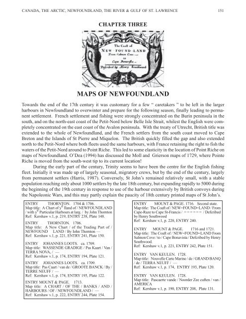
<strong>MAPS</strong> <strong>OF</strong> <strong>NEWFOUNDLAND</strong><br />
Towards the end of the 17th century it was customary for a few “ caretakers ” to be left in the larger<br />
harbours in Newfoundland to overwinter and prepare for the following season, finally leading to permanent<br />
settlement. French settlement and fishing were strongly concentrated on the Burin peninsula in the<br />
south, and on the north-east coast of the Petit-Nord below Belle Isle Strait, whilest the English were completely<br />
concentrated on the east coast of the Avalon peninsula. With the treaty of Utrecht, British title was<br />
extended to the whole of Newfoundland, and the French settlers from the south coast moved to Cape<br />
Breton and the Islands of St Pierre and Miquelon. The British quickly filled the gap and also extended<br />
north to the Petit-Nord where both fleets used the same harbours, with France retaining the right to fish the<br />
waters of the Petit-Nord around to Point Riche. This led to some elasticity in the location of Point Riche on<br />
maps of Newfoundland. O’Dea (1994) has discussed the Moll and Grierson maps of 1729, where Pointe<br />
Riche is moved from the south-west tip to its current location!<br />
During the early part of the century, Trinity seems to have been the centre for the English fishing<br />
fleet. Initially it was made up of largely seasonal, migratory crews, but by the end of the century, largely<br />
from permanent settlers (Harris, 1987). Conversely, St John’s remained relatively small, with a stable<br />
population reaching only about 1000 settlers by the late 18th century, but expanding rapidly to 5000 during<br />
the beginning of the 19th century in response to use of the harbour extensively by British convoys during<br />
the Napoleonic Wars, and this may partly explain the paucity of 18th century printed maps of St John’s.<br />
ENTRY THORNTON. 1704 & 1706.<br />
Map title: A Chart of y e Iland of / <strong>NEWFOUNDLAND</strong><br />
/ with y e Particular Harbours at larg. / by John Thornton<br />
Ref: Kershaw v.1, p. 219, ENTRY 238, Plate 148.<br />
ENTRY THORNTON. 1706.<br />
Map title: A New Chart / of the Trading Part of /<br />
NEWFOUND LAND / By Iohn Thornton —<br />
Ref: Kershaw v.1, p. 221, ENTRY 241, Plate 150.<br />
ENTRY JOHANNES LOOTS. ca. 1709.<br />
Map title: WASSENDE GRADIGE / Pas Kaart / Van /<br />
TERRA NOVA, / —<br />
Ref: Kershaw v.1, p. 174, ENTRY 194, Plate 121.<br />
ENTRY JOHANNES LOOTS. ca. 1709.<br />
Map title: Pas Caart / van de / GROOTE BANCK / By /<br />
TERRE NEUFF / —<br />
Ref: Kershaw v.1, p. 174, ENTRY 195, Plate 122.<br />
ENTRY MOUNT & PAGE. 1713.<br />
Map title: A CHART / <strong>OF</strong> THE / BANKS / AND /<br />
HARBOURS / <strong>OF</strong> / <strong>NEWFOUNDLAND</strong> / —<br />
Ref: Kershaw v.1, p. 222, ENTRY 244, Plate 154.<br />
ENTRY MOUNT & PAGE. 1716. Second state.<br />
Map title: The Coaft of / NEW=FOUND=LAND / From<br />
Cape-Raze to Cape St-Francis / = = = = = = / Defcribed<br />
by Henry Southwood<br />
Ref: Kershaw v.1, p. 220, ENTRY 240.<br />
ENTRY MOUNT & PAGE. 1716 and 1721.<br />
Map title: The Coaft of / NEW=FOUND=LAND From<br />
Salmon Cove / to / Cape Bonavista / Defcribed by Henry<br />
Southwood.<br />
Ref: Kershaw v.1, p. 221, ENTRY 242, Plate 151.<br />
ENTRY VAN KEULEN. 1728.<br />
Map title: Nouvelle Carte Marine / de / GRAND BANQ<br />
/ de / TERRA NEUFF / —<br />
Ref: Kershaw v.1, p. 174, ENTRY 193, Plate 120.<br />
ENTRY VAN KEULEN. 1728.<br />
Map title: Pascaerte vande / Noorder Zee cuften / van /<br />
AMERICA<br />
Ref: Kershaw v.1, p. 190, ENTRY 208, Plate 131.
152 EARLY PRINTED <strong>MAPS</strong> <strong>OF</strong> CANADA<br />
ENTRY 511. MOLL- LAHONTAN. 1703.<br />
Plate: 366.<br />
Map title: [NEW = / FOUND / LAND.]<br />
Map size: 16.2 x 10.8 cm.<br />
Published in: New Voyages to North America.<br />
LaHontan 1703.<br />
LC F1030.L178 1703; <strong>McMaster</strong> <strong>University</strong> B 13471.<br />
Inside the neat-line in the top left corner is “ H. Moll<br />
Fecit. / Vol. I. p. 225 ”. This format of Newfoundland,<br />
with a truncated top, was subsequently used by<br />
Moll for his series of maps of the Gulf of St. Lawrence<br />
in his Atlas Minor (Entry 571-574).<br />
ENTRY 512. VAN KEULEN. 1728.<br />
Plate: 367.<br />
Map title: Carte Nouvelle Contenant la Partie<br />
d’Amerique le plus Septentrionale / ou sont<br />
Exactement decrites les provinces Comme le<br />
Canada ou Nouvelle France / la Nouvelle Ecosse<br />
l’Accadia et Isle et Banc de Terre Neuve / —.<br />
Map size: 51.7 x 58.2 cm.<br />
Published in: De Nieuwe Groote Lightende Zee-<br />
Fakkel ‘t Vierde Deel —. Amsterdam 1728, 1782.<br />
S.M.A., A III 100; NMC 52142; LC G1059 .V6<br />
1782 Vault.<br />
Ref: Koeman Keu 113 A, Keu 113 B; LC Phillips<br />
1170, 3660.<br />
Plate 367. Van Keulen's chart of Newfoundland first published in the 1728 Dutch<br />
edition of his Zee-Fakkel and completely retaining the character of the 17th century<br />
Dutch charts. Entry 512. ( Courtesy of the National Archives of Canada ).
CANADA, THE ARCTIC, <strong>NEWFOUNDLAND</strong>, THE RIVER & GULF <strong>OF</strong> ST. LAWRENCE 153<br />
Plate 366. The first of Moll's maps of Newfoundland. It was engraved for<br />
the first English edition of Lahontan in 1703. Moll then used the same<br />
format for his subsequent maps in his Atlas Minor. Entry 511.
154 EARLY PRINTED <strong>MAPS</strong> <strong>OF</strong> CANADA<br />
Plate 369. This large fold-out chart was originally published as two separate charts by Thorn<br />
charts have been joined to form this impressive map of the<br />
ENTRY 513. CUTLER 1728.<br />
Plate: 368.<br />
Map title: The Coaft of / <strong>NEWFOUNDLAND</strong> /<br />
From / Placencia to Cape Bonavifta<br />
Map size: 15.9 x 24.2 cm.<br />
Published in: Atlas Maritimus London 1728.<br />
LC G1059 .A7 1728 Vault; BN du Q G 1015 A84<br />
1728 CAR.<br />
Ref: BN du Q # 7; LC Phillips 3298.<br />
This map is the left-hand side of a full folio page.<br />
ENTRY 514. MOUNT & PAGE. 1737. Third<br />
state.<br />
Plate: 369.<br />
Map title: The Coaft of / NEW=FOUND=LAND<br />
/ From Cape-Raze to Cape S t .-Francis /<br />
Defcribed by Henry Southwood & The<br />
Coaft of / NEW =FOUND= LAND / From<br />
Salmon Cove / to / Cape Bonavifta / Defcribed<br />
by Henry Southwood<br />
Map size: 42.7 x 103 cm.<br />
Published in: The English Pilot the Fourth Book<br />
—1737, 1745, 1749.<br />
LC G1106 .P5E5 1737, 1745, & 1749 Vault;<br />
Memorial <strong>University</strong> G 3436 P5 1721 & 1730 S6.<br />
Ref: LC Phillips 1171; Kershaw Entry 240, p.<br />
220, Plate 149, &151 .<br />
“ Ia Clark fculp ” is engraved both bottom right<br />
and left as a result of two maps being joined.
CANADA, THE ARCTIC, <strong>NEWFOUNDLAND</strong>, THE RIVER & GULF <strong>OF</strong> ST. LAWRENCE 155<br />
ton in 1689 and then by Mount & Page in 1707 & 1713. In the editions of 1727-1749, the two<br />
Avalon Peninsula. Entry 514. ( Courtesy of the Library of Congress ).<br />
ENTRY 515. BELLIN. 1744.<br />
Plate: 370.<br />
Map title: CARTE DE / L’ISLE DE TERRE-<br />
NEUVE / Dresfée par N.B. Ingenieur au Dépoft<br />
/ des Cartes et Plans de la Marine. / 1744.<br />
Map size: 28.7 x 36.2 cm.<br />
Published in: Histoire et Description Generale<br />
de la Nouvelle France. Charlevoix. Paris 1744.<br />
—TOME PREMIER A PARIS, Chez ROLIN—<br />
M.DCC.XLIV. Pierre-François-Xavier de<br />
Charlevoix.<br />
NMC 006., BN 8 o Ed. P.Angrand.778-780, BN 4 0<br />
Ed. Lk 12 762 D; BN du Q, RES AD 46.<br />
Ref: BN du Q # 176.<br />
“ Dheulland Sculp.” is engraved in the bottom right<br />
corner, outside the neat-line, and “ 21.”, is engraved<br />
on its side, outside the left-hand neat-line.<br />
ENTRY 516. BELLIN-ARKSTEE &<br />
MERKUS. 1756.<br />
Plate: 371.<br />
Map title: KARTE VON DEM / EYLANDE<br />
TERRE-NEUVE / —1744.<br />
Map size: 28.5 x 35.7 cm.<br />
Published in: Allgemeine Historie der Reisen zu<br />
Wasser und zu Lande. Leipzig 1756.<br />
National Library of Canada F 5057 C45 Reserve.<br />
Engraved outside the border, top right is “ No. 6 ”,<br />
and bottom right “ T.XIV. E.”.
156 EARLY PRINTED <strong>MAPS</strong> <strong>OF</strong> CANADA<br />
Plate 368. Map of south-east Newfoundland by Cutler<br />
published in his Atlas Maritimus in 1728. Entry 513.<br />
( Courtesy of the Clements Library ).
CANADA, THE ARCTIC, <strong>NEWFOUNDLAND</strong>, THE RIVER & GULF <strong>OF</strong> ST. LAWRENCE 157<br />
Plate 370. Map of Newfoundland by Bellin , published in 1744. Typical of Bellin's careful work, this<br />
detailed map of Newfoundland stood as the cartographic model for the next thirty years, and was copied<br />
by several other cartographers. Entry 515. ( Courtesy of the Bibliothèque Nationale du Québec ).
158 EARLY PRINTED <strong>MAPS</strong> <strong>OF</strong> CANADA<br />
Plate 371. Map of Newfoundland from Allgemeine Historie der Reisen zu<br />
Wasser und zu Lande. Leipzig 1756, closely copied from Bellin's<br />
equivalent map shown above. Entry 516. ( Courtesy of the National Library of Canada ).
CANADA, THE ARCTIC, <strong>NEWFOUNDLAND</strong>, THE RIVER & GULF <strong>OF</strong> ST. LAWRENCE 159<br />
Plate 372. Bellin's map of Port Dauphin published in Histoire et<br />
Description Generale de la Nouvelle France. Charlevoix. Paris 1744.<br />
Entry 517. ( Courtesy of the Bibliothèque Nationale du Québec ).<br />
Plate 373. Map of Port Dauphin from from Allgemeine Historie der Reisen<br />
zu Wasser und zu Lande. Leipzig 1756, closely copied from Bellin's equivalent<br />
map shown above. Entry 518. ( Courtesy of the National Library of Canada ).
160 EARLY PRINTED <strong>MAPS</strong> <strong>OF</strong> CANADA<br />
Plate 374. Bellin's map of Port Plaisance published in Histoire et<br />
Description Generale de la Nouvelle France. Charlevoix. Paris 1744.<br />
Entry 519. ( Courtesy of the Bibliothèque Nationale du Québec ).<br />
Plate 375. Map of Port Plaisance from Allgemeine Historie der Reisen zu Wasser<br />
und zu Lande. Leipzig 1756, closely copied from Bellin's equivalent map shown above.<br />
Entry 520. ( Courtesy of the National Library of Canada ).
CANADA, THE ARCTIC, <strong>NEWFOUNDLAND</strong>, THE RIVER & GULF <strong>OF</strong> ST. LAWRENCE 161<br />
ENTRY 517. BELLIN. 1744.<br />
Plate: 372.<br />
Map title: PLAN DU PORT DAUPHIN / ET<br />
DE SA RADE / Avec l’Éntrée de Labrador. / Par<br />
N.B.Ing.au D. de la M. / 1744<br />
Map size: 19.9 x 27.8 cm.<br />
Published in: Histoire et Description Generale<br />
de la Nouvelle France. Charlevoix. Paris 1744.<br />
BN Lk12 762 Vol 2; BN du Q, RES AD 46.<br />
Ref. BN du Q # 278.<br />
Bottom right is “ 6 ” rotated on its side, outside<br />
the neat-line.<br />
ENTRY 518. BELLIN-ARKSTEE & MERKUS.<br />
1756.<br />
Plate: 373.<br />
Map title: GRUNDRISS DES HAFENS DAU-<br />
PHIN / UND SEINER RHEEDE —1744.<br />
Map size: 19.7 x 28 cm.<br />
Published in: Allgemeine Historie der Reisen zu<br />
Wasser und zu Lande. Leipzig 1756.<br />
National Library of Canada F 5057 C45 Reserve.<br />
Engraved outside the border, top right, is “ N o .17 ”,<br />
and bottom right “ T.XIV.G.”<br />
Plate 376. Map of Newfoundland by Robert de Vaugondy published in his<br />
Atlas Portatif. Entry 522. ( Courtesy of the National Archives of Canada ).
162 EARLY PRINTED <strong>MAPS</strong> <strong>OF</strong> CANADA<br />
Plate 377. Chart of the Avalon Peninsula published in the English Pilot Fourth book in 1755, 1758, 1759, 1<br />
was finally re-engraved in 1778. The insets below show detail of the inset of Chebucto Harbour and particula
CANADA, THE ARCTIC, <strong>NEWFOUNDLAND</strong>, THE RIVER & GULF <strong>OF</strong> ST. LAWRENCE 163<br />
760, 1767, 1773, & 1775. By the 1767 edition the plate was extremely worn but it continued to be used until it<br />
rly the change in style of the compass rose in the re-engraved edition. Entry 523. ( Courtesy of the Library of Congress ).
164 EARLY PRINTED <strong>MAPS</strong> <strong>OF</strong> CANADA<br />
Plate 378. The final state of the Mount & Page chart of the Avalon Peninsula. This plate was re-engraved for<br />
the worn plate. As a result the impressions are dark with rather wider line engraving along the coastlines and
CANADA, THE ARCTIC, <strong>NEWFOUNDLAND</strong>, THE RIVER & GULF <strong>OF</strong> ST. LAWRENCE 165<br />
the 1778, 1780, & 1784 editions of the English Pilot Fourth Book and basically was an extensive re-working of<br />
with a simpler compass rose inside the inset of Chebucto Harbour. Entry 524. ( Courtesy of the Library of Congress ).
166 EARLY PRINTED <strong>MAPS</strong> <strong>OF</strong> CANADA<br />
ENTRY 519. BELLIN. 1744.<br />
Plate: 374.<br />
Map title: CARTE DES / BAYES, RADES ET PORT<br />
/ DE PLAISANCE / dans l’Isle de Terre Neuve /<br />
— / 1744.<br />
Map size: 19.5 x 28.5 cm.<br />
Published in: Histoire et Description Generale de<br />
la Nouvelle France. Charlevoix. Paris 1744. —<br />
TOME PREMIER A PARIS, Chez ROLIN—<br />
M.DCC.XLIV. Pierre-François-Xavier de<br />
Charlevoix.<br />
NMC., BN 8o Ed. P.Angrand.778-780, BN 40 Ed.<br />
Lk12 762 D; BN du Q, RES AD 46.<br />
Ref: BN du Q # 198.<br />
“Dheulland Sculp.” is engraved in the bottom right<br />
corner, outside the neat-line, and “ 2. ”, is engraved<br />
on its side outside the left-hand neat-line.<br />
ENTRY 520. BELLIN-ARKSTEE &<br />
MERKUS. 1756.<br />
Plate: 375.<br />
Map title: KARTE VON DEN / BAYEN,<br />
RHEEDEN UND HAFEN / VON PLAISANCE<br />
/ —1744.<br />
Map size: 19.2 x 28.2 cm.<br />
Published in: Allgemeine Historie der Reisen zu<br />
Wasser und zu Lande. Leipzig 1756.<br />
National Library of Canada F 5057 C45 Reserve.<br />
Engraved outside the border, top right, is “ N o . 7 ”.<br />
ENTRY 521. VAUGONDY. 1749. First state.<br />
Map title: ISLE DE / TERRE-NEUVE / ... /<br />
Par le S r .. Robert de Vaugondy / Fils de M R .<br />
ROBERT Geog ord. du Roi / Avec Privilege /<br />
1749<br />
Map size: 16.6 x 19.1 cm.<br />
Published in: Atlas Portatif, Universel et<br />
Militaire, composé — Paris — 1748-(49).<br />
BN G 3216.<br />
The page number, “ 71 ” is engraved top right,<br />
outside the neat-line.<br />
Plate 379. Port Plaisance published by Le Rouge in his atlas Récuëil Des Planse De L’Amérique<br />
Septentrionale. Entry 525. ( Courtesy of the Library of Congress ).
CANADA, THE ARCTIC, <strong>NEWFOUNDLAND</strong>, THE RIVER & GULF <strong>OF</strong> ST. LAWRENCE 167<br />
ENTRY 522. VAUGONDY. [1749]. Second<br />
state.<br />
Plate: 376.<br />
Map title: ISLE DE / TERRE-NEUVE / ... /<br />
Par le S r .. Robert de Vaugondy / Fils de M R .<br />
ROBERT Geog ord. du Roi / Avec Privilege / 1749<br />
Map size: 16.6 x 19.1 cm.<br />
Published in: Atlas Portatif, Universel et<br />
Militaire, composé — Paris — 1748-(49).<br />
BN Ge FF 9869, BN Ge FF 2658; NMC G 1015.<br />
R61 1749 fol. Vault; LC G1015 .R58 1749 Vault.<br />
Ref: LC Phillips 608.<br />
The page number, “ 199 ” is engraved top right,<br />
outside the neat-line.<br />
ENTRY 523. MOUNT & PAGE. 1755-1775.<br />
Plate: 377.<br />
Map title: A / New and Correct CHART / of<br />
the Coaft of / NEW FOUNDLAND / — / Sold<br />
by W & I. Mount & T. Page on Tower Hill.<br />
Map size: 46.9 x 60 cm.<br />
Published in: The English Pilot. The Fourth<br />
Book. 1755-1775.<br />
LC G1106 .P5E5 1755, 1758, 1759, 1760, 1767,<br />
1773 & 1775 Vault.<br />
Ref: LC Phillips 1171.<br />
There is an inset of “ Chebucto Harbour in NOVA<br />
SCOTIA ” at the top right. The original plate<br />
appears to have been used for editions in 1775,<br />
1773, 1767, 1760, 1759, 1758 & 1755. Finally<br />
of course, it was extremely worn, and the<br />
impressions for several of the last editions are poor.<br />
Plate 380. Gibson's map of<br />
Newfoundland from his Atlas<br />
Minimus, or a New Set of<br />
Pocket Maps.<br />
Entry 526.<br />
( Courtesy of the National Archives of Canada ).
168 EARLY PRINTED <strong>MAPS</strong> <strong>OF</strong> CANADA<br />
Plate 381. The map of Newfoundland from the London Magazine which was<br />
published in 1762. Entry 527. ( Courtesy of the National Archives of Canada ).<br />
ENTRY 524. MOUNT & PAGE. 1778-1784.<br />
Plate: 378.<br />
Map title: A / New and Correct CHART / of<br />
the Coaft of / NEW FOUNDLAND / — / Sold<br />
by W & I. Mount & T. Page on Tower Hill.<br />
Map size: 42 x 100.8 cm.<br />
Published in: The English Pilot the Fourth Book<br />
—1778, 1780, 1784<br />
LC G1106 .P5E5 1778, 1780, & 1784 Vault.<br />
Ref: LC Phillips 1171.<br />
The original plate appears to have been entirely<br />
re-worked, and re-issued virtually without change,<br />
apart from rather more extensive hatching along<br />
the coasts. There is still an inset of “ Chebucto<br />
Harbour in NOVA SCOTIA ” at the top right, with<br />
the compass rose obviously re-engraved.<br />
ENTRY 525. LE ROUGE. 1755.<br />
Plate: 379.<br />
Map title: CARTE DES / BAYES, RADES ET<br />
PORT / DE PLAISANCE. / dans l’Isle de Terre-<br />
Neuve / Dresse par M. Bellin / Pour l’Histoire<br />
du Canada / Par le P. Charlevoix<br />
Map size: 17.2 x 25.2 cm.<br />
Published in: Récuëil Des Planse De L’Amérique<br />
Septentrionale A Paris chez le S r . Le Rouge Jugénieu<br />
Géographe du Roi Rue des Augustina 1755.<br />
BN Ge FF 209, L.C. G1109 A1L4 1755 Vault,<br />
BN Ge FF 13338.<br />
Ref: LC Phillips 1185.
CANADA, THE ARCTIC, <strong>NEWFOUNDLAND</strong>, THE RIVER & GULF <strong>OF</strong> ST. LAWRENCE 169<br />
Plate 382. Map of Newfoundland published anonymously around 1762.<br />
Entry 529. ( Courtesy of Memorial <strong>University</strong> Library ).
170 EARLY PRINTED <strong>MAPS</strong> <strong>OF</strong> CANADA<br />
Plate 383. Map of Newfoundland copied from the similar map in the London Magazine but<br />
published in the Gentlemans & London Magazine in 1762; & in A Voyage to North America<br />
— . in 1766. Entry 530. ( Courtesy of the National Library of Canada ).<br />
ENTRY 526. GIBSON & BOWEN. 1758.<br />
Plate: 380.<br />
Map title: NEW- / FOUND / LAND<br />
Map size: 6.4 x 9.4 cm.<br />
Published in: Atlas Minimus, or a New Set of<br />
Pocket Maps / ... / By J. Gibson ... Revif’d,<br />
Corrected and Improved By Eman Bowen...Jan y<br />
2 d . 1758...London.<br />
BN Ge FF 667, LC G1015 .G5 1758, 1774, 1779,<br />
1792; NMC 104408; BL Maps c.7.a.21.<br />
Ref: LC Phillips 621, 3516, 3518, 676.<br />
Outside neat-line, top right corner is “ 45 ”.<br />
ENTRY 527. LONDON MAGAZINE. 1762.<br />
Plate: 381.<br />
Map title: A New MAP, of the / only useful and<br />
frequented / part of / NEW FOUND / LAND. /<br />
By Tho s .. Kitchin Geog r ..<br />
Map size: 17.5 x 24 cm.<br />
Published in: London Magazine v.31, Aug. 1762,<br />
p.465.<br />
NMC 9, 17, 18; Arch. Newfoundland MG.97.<br />
Ref: Jolly LOND-215.<br />
Engraved above the neat-line, top centre, is “ For<br />
the London Magazine ”.<br />
ENTRY 528. GENTLEMANS & LONDON<br />
MAGAZINE. 1762.<br />
[see Plate: 383.]<br />
Map title: A New MAP, of the / only useful and<br />
frequented / part of / NEW FOUND / LAND. /<br />
By Tho s .. Kitchin Geog r .<br />
Map size: 17.5 x 24 cm.<br />
Published in: Gentlemans & London Magazine<br />
v.31, Aug. 1762, p.578; & in: A Voyage to North<br />
America — . Exshaw & Potts Dublin 1766.<br />
Ref: Jolly GAL-96.
CANADA, THE ARCTIC, <strong>NEWFOUNDLAND</strong>, THE RIVER & GULF <strong>OF</strong> ST. LAWRENCE 171<br />
Plate 384. Map of Newfoundland by T. Kitchin, again a furthur derivative of the equivalent London<br />
Magazine map. Entry 531. ( Courtesy of the Bibliothèque Nationale du Québec ).<br />
ENTRY 529. ANON ca. 1762.<br />
Plate: 382.<br />
Map title: [INSEL / NEU-LAND od. / TERRE-<br />
NEUVE / Olim Avalon ]<br />
Map size: 29.2 x 23.1 cm.<br />
Published in: source not located<br />
Memorial <strong>University</strong> G 3435 1762 I5.<br />
ENTRY 530. EXSHAW & POTTS. 1766.<br />
Plate: 383.<br />
Map title: A New MAP of the / only useful and<br />
frequented / part of / NEW FOUND / LAND /<br />
By Tho s . Kitchin Geog r .<br />
Map size: 17.5 x 24.2 cm.<br />
Published in: A Voyage to North America —.<br />
Dublin MDCCLXVI.<br />
BN du Q RES AE 53 v.1; National Library of<br />
Canada FC305 C422 1766 v.2 Reserve; <strong>McMaster</strong><br />
<strong>University</strong> B 15982.<br />
Ref: BN du Q # 1008.<br />
Although the engraving has been very closely copied<br />
from the London Magazine edition , it is in<br />
fact an entirely new plate that was used for both<br />
A Voyage to America , as well as earlier in the<br />
Gentlemans & London Magazine in 1762.<br />
ENTRY 531. KITCHIN ca. 1766.<br />
Plate: 384.<br />
Map title: A New MAP, of the / MOST FRE-<br />
QUENTED / PART <strong>OF</strong> / NEW FOUND /<br />
LAND. / By Tho s . Kitchin Geogr r .<br />
Map size: 17.8 x 24.5 cm.<br />
Published in:<br />
LC G3435 1762 .K5 Vault; BN du Q G 3435 1760 K5.<br />
Ref: BN du Q # 1011; Sellers & van Ee.
172 EARLY PRINTED <strong>MAPS</strong> <strong>OF</strong> CANADA<br />
Plate 385. Map of Newfoundland by Raspe published in 1764. Entry 532.<br />
ENTRY 532. RASPE. 1764.<br />
Plate: 385.<br />
Map title: CARTE VON DER INSEL /<br />
TERRE-NEUVE / entworfen von Bellin<br />
Map size: 22.4 x 22.7 cm.<br />
Published in: Schau Platz des gegenwærtigen<br />
Kreigs, --- Belagerungen im Jahre 1762. Zehender<br />
und letzer Theil. Nürnberg.<br />
NMC G1106 S1S32 1764; G3600 1785 .B4 Vault; LC<br />
G3435 1785 .B4 Vault; BN du Q. G 3435 1764 B4.<br />
Ref: BN du Q # 228.<br />
Engraved outside the neat-line, in the top right<br />
corner, is “ N o . 147 ” and bottom right “ Nürnberg<br />
in der Raspifchen Handlung ”.<br />
( Courtesy of the National Archives of Canada ).<br />
ENTRY 533. MARCO COLTELLINI. 1763.<br />
Plate: 386.<br />
Map title: Nuova, e corretta Carta dell’Isola di<br />
Terra Nuova.<br />
Map size: 20.7 x 16.3 cm.<br />
Published in: Il Gazzettiere Americano<br />
contenente un Distinto Ragguaglio di Tutte le<br />
Partie del Nuovo Mondo — MDCCLXIII.<br />
and in; Atlante dell’America —— Livorno,<br />
1777 without change.<br />
NMC E 14 A516 1763 v.3; Arch. Newfoundland<br />
MG.86.1.<br />
Ref: LC Phillips 1161.<br />
“ D Vorem. Rofsi Sc.” is engraved within the border,<br />
lower right.
CANADA, THE ARCTIC, <strong>NEWFOUNDLAND</strong>, THE RIVER & GULF <strong>OF</strong> ST. LAWRENCE 173<br />
Plate 386. Map of Newfoundland published in Il Gazzettiere Americano —, 1763 and in<br />
Atlante dell’America —— in 1777. Entry 533.<br />
( Courtesy of the National Archives of Canada ).
174 EARLY PRINTED <strong>MAPS</strong> <strong>OF</strong> CANADA<br />
Plate 387. Bellin's chart of Port Plaisance from his Petit Atlas Maritime 1764. Entry 534.<br />
( Courtesy of the National Archives of Canada ).<br />
ENTRY 534. BELLIN. 1764.<br />
Plate: 387.<br />
Map title: CARTE DES / BAYES, RADES,ET<br />
PORT / DE PLAISANCE / dans l’Isle de Terre-<br />
Neuve.<br />
Map size: 14.9 x 21.6 cm.<br />
Published in: Le Petit Atlas Maritime; recueil de<br />
Cartes et plans des Quatre Parties du Monde, —.<br />
Paris 1764.<br />
NMC A 903-1764, BN Ge EE 2262 (1), LC G<br />
1019 .B45 1764 Vault; BN du Q, G 1105 B32 1764<br />
CAR; Arch Newfoundland MG.102 (5).<br />
Ref: BN du Q # 199; LC Phillips 3508.<br />
“ Tome I. N o . 20.” is engraved in the top right corner,<br />
outside the neat-line, and “ croisey.sculp.” at<br />
the bottom right.<br />
ENTRY 535. BELLIN. 1764.<br />
Plate: 388.<br />
Map title: LE DÉTROIT DE / BELLE-ISLE.<br />
Map size: 20.8 x 15.9 cm.<br />
Published in: Le Petit Atlas Maritime; recueil<br />
de Cartes et plans des Quatre Parties du<br />
Monde, —. Paris 1764.<br />
NMC A 903-1764, BN Ge EE 2262 (1), LC<br />
G 1019 .B45 1764 Vault; BN du Q, G 1105 B32<br />
1764 CAR; Arch. Newfoundland MG.102 (2).<br />
Ref: BN du Q # 231; LC Phillips 3508.<br />
“ Tome I. N o . 14.” is engraved in the top right corner,<br />
outside the neat-line, and “ A. Voyez la Carte<br />
du Golphe de St.Laurent N.” along the left-hand<br />
neat-line.<br />
ENTRY 536. BELLIN. 1764.<br />
Plate: 389.<br />
Map title: CARTE DU HAVRE / DE / SAINT<br />
JEAN / dans l’Ifle de Terre-neuve.<br />
Map size: 15.9 x 20.6 cm.<br />
Published in: Le Petit Atlas Maritime; recueil<br />
de Cartes et plans des Quatre Parties du<br />
Monde, —. Paris 1764.<br />
NMC A 903-1764, BN Ge EE 2262 (1), LC G<br />
1019 .B45 1764 Vault; BN du Q, G 1105 B32<br />
1764 CAR; Arch. Newfoundland M6.102(6).<br />
Ref: BN du Q # 222; LC Phillips 3508.<br />
“ Tome I. N o . 21.” is engraved in the top right corner,<br />
outside the neat-line.
CANADA, THE ARCTIC, <strong>NEWFOUNDLAND</strong>, THE RIVER & GULF <strong>OF</strong> ST. LAWRENCE 175<br />
ENTRY 537. GRIERSON 1767.<br />
Plate: 390.<br />
Map title: The Coaft of / NEW FOUND=LAND<br />
/ From Cape Raze to Cape S t . Francis / Sold by<br />
George Grierson at the / two Bibles in Effex<br />
Street / Dublin<br />
Map size: 41.1 x 49 cm.<br />
Published in: The English Pilot, the Fourth Book<br />
Dublin 1767.<br />
LC G1106 .P5E5 1767b Vault; Memorial<br />
<strong>University</strong> G 3436 P5 1749 B3.<br />
Ref: LC Phillips 1162.<br />
Engraved inside the neat-line lower left is “ Ja<br />
Barlow fculp ”.<br />
ENTRY 538. JEFFERYS. 1770. First state.<br />
Map title: A GENERAL CHART / <strong>OF</strong> THE<br />
ISLAND <strong>OF</strong> / <strong>NEWFOUNDLAND</strong> / with the<br />
Rocks & Soundings. / — / By / James Cook<br />
and Michael Lane Surveyors / and Others. /<br />
LONDON / Publifh’d according to Act of<br />
Parliament. 10 th . May 1770. / By Thomas<br />
Plate 388. Bellin's chart of Belle-Isle strait<br />
from his Petit Atlas Maritime 1764.<br />
Entry 535.<br />
( Courtesy of the National Archives of Canada ).<br />
Jefferys Geographer to the KING.<br />
Map size: 54.6 x 56 cm.<br />
Published in: source not located<br />
NMC 78672.<br />
ENTRY 539. JEFFERYS. 1775. Second state.<br />
Plate: 391.<br />
Map title: A GENERAL CHART / <strong>OF</strong> THE<br />
ISLAND <strong>OF</strong> / <strong>NEWFOUNDLAND</strong> / with the<br />
Rocks & Soundings. / — / By / James Cook<br />
and Michael Lane Surveyors / and Others. /<br />
LONDON / Publifh’d according to Act of<br />
Parliament. 10 th . May 1775. / By Thomas<br />
Jefferys Geographer to the KING. / Printed for<br />
Rob t . Sayer & Jn o . Bennett / N o . 53 in Fleet<br />
Street<br />
Map size: 54.6 x 56 cm.<br />
Published in: American Atlas No. 14, 1775,<br />
1776[1780], 1777, 1783. & The North-<br />
American Pilot. 1770,1776 [1780].<br />
NMC 52302, 123714, G1100 C656 1775, G1106<br />
P5N6 1770, 1777 v.1; LC G1015 F22 1775,<br />
1776[1780], 1777, 1778, 1783. Vault; BN du Q<br />
G 1100 A5 1781 CAR.<br />
Ref: BN du Q # 1; LC Phillips 1208.<br />
The imprint “ Printed for Rob t . Sayer & Jn o .<br />
Bennett / N o . 53 in Fleet Street.” has been added<br />
below the title.<br />
ENTRY 540. JEFFERYS. 1775. Third state.<br />
Map title: A GENERAL CHART / <strong>OF</strong> THE<br />
ISLAND <strong>OF</strong> / <strong>NEWFOUNDLAND</strong> / with the<br />
Rocks & Soundings. / — / Printed for Rob t .<br />
Sayer Map & Chartfeller / N o . 53 in Fleet Street.<br />
Map size: 54.6 x 56 cm.<br />
Published in: The North American Pilot—. 1794<br />
and in The North American Pilot for<br />
Newfoundland, Labradore, the Gulf and River<br />
St. Laurence — London Sayer and Bennett 1784.<br />
LC G1106 .P5N6 1788 V.1.Vault; NMC 52303,<br />
G 1106 .P5N6 1794 fol Vault.<br />
Ref: LC Phillips 10325.<br />
There appears to be only a change in the title with<br />
Rob. Sayer remaining as sole publisher.
176 EARLY PRINTED <strong>MAPS</strong> <strong>OF</strong> CANADA<br />
Plate 389. Bellin's chart of the harbour of St. John from his Petit Atlas Maritime 1764.<br />
Entry 536. ( Courtesy of the National Archives of Canada ).
CANADA, THE ARCTIC, <strong>NEWFOUNDLAND</strong>, THE RIVER & GULF <strong>OF</strong> ST. LAWRENCE 177<br />
Plate 390. Grierson's chart of the Avalon Peninsula which he pirated from the Mount &<br />
Page edition of the English Pilot, publishing it himself also as The English Pilot, the<br />
Fourth Book, but in Dublin in 1767. The plates are entirely re-engraved as very close<br />
copies of the originals. Entry 537. ( Courtesy of the Library of Congress ).
178 EARLY PRINTED <strong>MAPS</strong> <strong>OF</strong> CANADA
CANADA, THE ARCTIC, <strong>NEWFOUNDLAND</strong>, THE RIVER & GULF <strong>OF</strong> ST. LAWRENCE 179<br />
Plate 391.<br />
Jefferys great chart of<br />
Newfoundland that was<br />
originally published in 1770.<br />
There appear to be four states<br />
of the plate with changes only<br />
made to the date of<br />
publication and the name of<br />
the publisher contained in the<br />
title. Editions appeared in 1770,<br />
1775, [1784] & 1794. The<br />
illustration here is the second<br />
state published in 1775.<br />
Entry 539.<br />
( Courtesy of the National Archives of Canada ).<br />
ENTRY 541. JEFFERYS. 1806. Fourth state.<br />
Map title: A GENERAL CHART / <strong>OF</strong> THE<br />
ISLAND <strong>OF</strong> / <strong>NEWFOUNDLAND</strong> / with the<br />
Rocks & Soundings. / — / By / James Cook<br />
and Michael Lane Surveyors / and Others. /<br />
LONDON / Publifh’d 12 May, 1794. by<br />
LAURIE & WHITTLE.53 Fleet Street.<br />
Map size: 54.6 x 56 cm.<br />
Published in: The First part of the North<br />
American Pilot —1799, 1806.<br />
NMC 52304; BN du Q, G 1186 P5C66 1815 CAR;<br />
LC G1106 .P5N6 1799 & 1806 Vault.<br />
Ref : BN du Q # 539; LC Phillips 1236, 4476.<br />
Again it appears that the only change is in the title<br />
with the publisher changing to Laurie & Whittle.<br />
ENTRY 542. SAYER & BENNETT. 1770.<br />
First state.<br />
Map title: A CHART / <strong>OF</strong> THE SOUTH-EAST<br />
PART / <strong>OF</strong> / <strong>NEWFOUNDLAND</strong>, / —<br />
Map size: 50 x 68 cm.<br />
Published in: The North American Pilot for<br />
Newfoundland, Labradore, the Gulf and River<br />
St. Laurence — London Sayer and Bennett v.1.<br />
1770.<br />
LC G1106 .P5N6 1770, v.1. Vault.<br />
Ref: LC Phillips 1209.<br />
Engraved below the border is “ London. Printed<br />
for R. Sayer and I. Bennett Map and Chartfeller,<br />
N o . 53 in Fleet Street 10 May.1770. ”, and top<br />
right “ III ”.<br />
ENTRY 543. SAYER & BENNETT. 1777. Second<br />
state.<br />
Map title: A CHART / <strong>OF</strong> THE SOUTH-EAST<br />
PART / <strong>OF</strong> / <strong>NEWFOUNDLAND</strong>, / —<br />
Map size: 50 x 68 cm.<br />
Published in: The North American Pilot for<br />
Newfoundland, Labradore, the Gulf and River<br />
St. Laurence — London Sayer and Bennett v.1.<br />
1777.<br />
LC G1106 .P5N6 1784[1788] Vault.<br />
Ref: LC Phillips 10325.<br />
Engraved below the border is “ London. Printed<br />
for R. Sayer and I. Bennett Map and Chartfeller,<br />
N o . 53 in Fleet Street 10 th .Feb y . 1777. ”, and top<br />
right “ III ”.
180 EARLY PRINTED <strong>MAPS</strong> <strong>OF</strong> CANADA<br />
ENTRY 544. ROBERT SAYER. 1788. Third<br />
state.<br />
Map title: A CHART / <strong>OF</strong> THE SOUTH-EAST<br />
PART / <strong>OF</strong> / <strong>NEWFOUNDLAND</strong>, / —<br />
Map size: 49.9 x 68 cm.<br />
Published in: The North American Pilot for<br />
Newfoundland, Labradore, the Gulf and River<br />
St. Laurence — London Sayer and Bennett 1784<br />
and in: The North American Pilot — 1794LC<br />
G1106 .P5N6 1784[1788] Vault; NMC G 1106<br />
.P5N6 1794 fol Vault.<br />
Ref: LC Phillips 10325.<br />
Top right corner, outside the neat-line, is “ III ” and<br />
bottom centre “ London. Printed for R. Sayer, Map<br />
& Chartfeller, N o . 53 in Fleet Street. Street .<br />
10 th .Feb y .1788.” The repetition presumably is the<br />
result of inaccurate erasing of the previous imprint!<br />
ENTRY 545. LAURIE & WHITTLE.<br />
[1794]1799, 1806. Fourth state.<br />
Plate: 392.<br />
Map title: A CHART / <strong>OF</strong> THE SOUTH-EAST<br />
PART / <strong>OF</strong> / <strong>NEWFOUNDLAND</strong>, / —<br />
Map size: 50 x 68 cm.<br />
Published in: The First part of the North<br />
American Pilot —1799, 1806.<br />
LC G1106 .P5N6 1799, 1806 Vault.<br />
Ref: LC Phillips 1236, 4476.<br />
Engraved below the border is “ Publifhed 12 May<br />
1794 . by LAURIE & WHITTLE, N o . 53 Fleet<br />
Street London.”.<br />
Plate 392. Chart of the Avalon peninsula which appeared as a number of states dated 1770,<br />
1777, 1788 & 1794. This is the final state with a Laurie & Whittle imprint but apparently no<br />
other changes. Entry 545. ( Courtesy of the National Archives of Canada ).
CANADA, THE ARCTIC, <strong>NEWFOUNDLAND</strong>, THE RIVER & GULF <strong>OF</strong> ST. LAWRENCE 181<br />
ENTRY 546. MANTE. 1772.<br />
Plate: 393.<br />
Map title: PLAN / of the Retaking / NEW-<br />
FOUNDLAND, / the Squadron commanded by /<br />
Lord Colville, / the Troops by Lieu t . Col. Amherst.<br />
Map size: 20.3 x 30.7 cm.<br />
Published in: The History of the Late War in<br />
North America....By Thomas Mante... London...<br />
MDCCLXXII.<br />
BN Ge FF 8726; National Library of Canada E<br />
199.M29; LC E199. M29.<br />
Top right corner outside the neat-line “ To face page<br />
467 ”. Above neat-line, top centre “ Engraved for<br />
M r . Mant’s History of the War in North America by<br />
T. Kitchin, Hydrographer to his Majesty. ” Bottom,<br />
outside the neat-line, is a table of contents.<br />
ENTRY 547. LE ROUGE. 1778.<br />
Plate: 394.<br />
Map title: L’ISLE / DE TERRE - NEUVE / Par<br />
/ James Cook M. Lane / --- / A PARIS / Chez le<br />
Rouge Rue des Grands Augustins / 1778 / avec<br />
Privilege du Roi.<br />
Map size: 53 x 53.7 cm.<br />
Published in: Pilote Americain Septentrional —<br />
Paris 1778-79. 2nd. Part.<br />
LC G1106 .P5L4 1778 V.2. Vault; G3437 .A8 1778<br />
.J4 Vault; NMC 136230.<br />
Ref: LC Phillips 10319.<br />
ENTRY 548. LE ROUGE. 1778.<br />
Plate: 395.<br />
Map title: PARTIE MERIDIONALE-<br />
ORIENTALE / DE L’ISLE / DE TERRE-<br />
NEUVE / —.1778<br />
Map size: 48.5 x 66 cm.<br />
Published in: Pilote Americain Septentrional -.<br />
Paris 1778-79. 2nd. Part.<br />
LC G1106 .P5L4 1778 v.2. Vault; G3437 .A8 1778<br />
.J4 Vault.<br />
Ref: LC Phillips 10319.<br />
Engraved top right is “ 12 ”.<br />
ENTRY 549. MOUNT & PAGE 1778-1784.<br />
Plate: 396.<br />
Map title: A CHART / of the / SOUTH-EAST<br />
COAST / <strong>OF</strong> / <strong>NEWFOUNDLAND</strong> / Printed<br />
for Mount & Page Tower-Hill / LONDON.<br />
Map size: 46.9 x 60 cm.<br />
Published in: The English Pilot. The Fourth<br />
Book. 1778, 1780, 1784.<br />
LC G1106 .P5E5 1784 Vault; Memorial <strong>University</strong><br />
G 3436 P5 1780 M6.<br />
Ref: LC Phillips 1171.<br />
ENTRY 550. ZATTA. 1778-9.<br />
Plate: 397.<br />
Map title: LE ISOLE / di / TERRA NUOVA / e<br />
/ CAPO BRETON / Di Nuova Projezione /<br />
VENEZIA 1778 / Prefso Antonio Zatta / Con<br />
Privilegio del Eccmo Senato.<br />
Map size: 42.8 x 32.2 cm.<br />
Published in: Atlante Novissimo. Venezia 1779-<br />
1785.<br />
LC G1015 .Z3 1785 Vault; NMC 1882.<br />
Ref: Phillips 650, 651.<br />
ENTRY 551. DEPOT DE LA MARINE 1782.<br />
Plate: 398.<br />
Map title: CARTE RÉDUITE / DE / L’ILE DE<br />
TERRE-NEUVE, / AVEC LES ROCHERS ET<br />
LES SONDES / — / 1782<br />
Map size: 88 x 57.9 cm.<br />
Published in: source not located<br />
Memorial <strong>University</strong> G 3436 P5 1782 F7.<br />
There is a depot stamp inside the simple cartouche<br />
below the date.
182 EARLY PRINTED <strong>MAPS</strong> <strong>OF</strong> CANADA
CANADA, THE ARCTIC, <strong>NEWFOUNDLAND</strong>, THE RIVER & GULF <strong>OF</strong> ST. LAWRENCE 183<br />
Plate 393. The harbour of St. John's<br />
published in The History of the Late War in<br />
North America by Thomas Mante in 1772.<br />
Entry 546. ( Courtesy of the National Library of Canada ).
184 EARLY PRINTED <strong>MAPS</strong> <strong>OF</strong> CANADA
CANADA, THE ARCTIC, <strong>NEWFOUNDLAND</strong>, THE RIVER & GULF <strong>OF</strong> ST. LAWRENCE 185<br />
Plate 394. Le Rouge<br />
published this version of<br />
Jefferys chart of<br />
Newfoundland in<br />
Pilote Americain<br />
Septentrional —,<br />
Paris 1778-79.<br />
Entry 547.<br />
( Courtesy of the Library of Congress ).<br />
ENTRY 552. DEPOT DE LA MARINE ca.<br />
1784. First state<br />
Plate: 399.<br />
Map title: CARTE REDUITE / DE / L’ILE DE<br />
TERRE-NEUVE / Dressée d’aprés les Plans Anglois<br />
de James Cook et Michael Lane, / ... / 1784<br />
Map size: 87.1 x 60.5 cm.<br />
Published in: Hydrographie Françoise. Recueil<br />
des cartes Marines / ... / Par feu M. Bellin,<br />
Ingénieur Hydrographe de Dépot et autrea.<br />
BN SH Pf 128 Div. 2 P 12; Memorial <strong>University</strong><br />
G 3436 P5 1784 F71.<br />
Below the cartouche is a “ Depot de la Marine ”<br />
stamp with fleurs-de-lis. Outside the neat-line, in<br />
the bottom right hand corner is engraved “ PRIX<br />
Trente Sols ” A single fleur-de-lis arrow is used<br />
on the central major line of longitude.<br />
ENTRY 553. BELLIN. ca. 1784. Second state.<br />
Plate: 400.<br />
Map title: CARTE REDUITE / DE / L’ILE DE<br />
TERRE-NEUVE / Dressée d’aprés les Plans Anglois<br />
de James Cook et Michael Lane, / ... / 1784<br />
Map size: 87.1 x 60.5 cm.<br />
Published in: Hydrographie Françoise. Recueil<br />
des cartes Marines / ... / Par feu M. Bellin,<br />
Ingénieur Hydrographe de Dépot et autrea.<br />
BN SH Pf 128 Div. 2 P12 1 , BN SH Pf 128 Div.5<br />
p4 1 ; LC G1059 .B43 1794.<br />
Ref: LC Phillips 589.<br />
In the second state of this map a large number of<br />
very minor changes have occurred. In a number<br />
of cases new physical features, port names etc.<br />
have been added, and all have been underlined in<br />
the plate. As well, underneath the primary cartouche,<br />
a note about James Cook has been added, and<br />
to the right of the cartouche a note about the Grand<br />
Banks has also been added. Below the table of<br />
latitudes and longitudes, in the centre of the map,<br />
there is an additional note added. Below the cartouche<br />
is a “ Depot de la Marine ” stamp with<br />
fleurs-de-lis. Outside the border on the right side<br />
at the bottom, is “ N o . 2 ” engraved on its side,<br />
with “ PRIX Trente Sols ” below the lower border.<br />
Two fleur-de-lis arrows are now used on<br />
major lines of longitude .
186 EARLY PRINTED <strong>MAPS</strong> <strong>OF</strong> CANADA<br />
Plate 395. Map of the Avalon peninsula published by Le Rouge, in the Pilote<br />
Americain Septentrional — Paris 1778-79. Entry 548. ( Courtesy of the Library of Congress ).<br />
Plate 396. Mount & Page produced this final chart of the Avalon peninsula<br />
for the 1778, 1780, & 1784 editions of The English Pilot. The Fourth<br />
Book. Entry 549.
CANADA, THE ARCTIC, <strong>NEWFOUNDLAND</strong>, THE RIVER & GULF <strong>OF</strong> ST. LAWRENCE 187<br />
Plate 397. Map of Newfoundland by Zatta published in 1778-79. Entry 550.<br />
( Courtesy of the National Archives of Canada ).
188 EARLY PRINTED <strong>MAPS</strong> <strong>OF</strong> CANADA<br />
Plate 398. A Depot de la Marine chart published in 1782. The source of this chart is<br />
puzzling since the cartography of north-eastern Newfoundland is quite different to anything<br />
published previously or subsequently. Entry 551. ( Courtesy of Memorial <strong>University</strong>, Newfoundland ).
CANADA, THE ARCTIC, <strong>NEWFOUNDLAND</strong>, THE RIVER & GULF <strong>OF</strong> ST. LAWRENCE 189<br />
Plate 399. Depot de la Marine chart published in 1784 replacing the previous chart.<br />
It is closely copied from the Cook & Lane survey which is acknowledged, and<br />
appeared as a number of states for at least 20 years. This is the first state of the plate.<br />
Entry 552. ( Courtesy of Memorial <strong>University</strong>, Newfoundland ).
190 EARLY PRINTED <strong>MAPS</strong> <strong>OF</strong> CANADA<br />
Plate 400. The second state of the Depot de la Marine chart copied from Cook & Lane.<br />
There are a large number of small changes made, but the additional note, added below the<br />
table of latitudes and longitudes in the centre of the map, quickly identifies it. Entry 553.<br />
( Courtesy of the Library of Congress ).
CANADA, THE ARCTIC, <strong>NEWFOUNDLAND</strong>, THE RIVER & GULF <strong>OF</strong> ST. LAWRENCE 191<br />
Plate 401. Faden published the Michael Lane survey of Newfoundland in A Journal of —<br />
Coast of Labrador — in 1792. Entry 558.<br />
( Courtesy of the National Archives of Canada ).


