

2011 - Geoinformatics
2011 - Geoinformatics
2011 - Geoinformatics

Create successful ePaper yourself
Turn your PDF publications into a flip-book with our unique Google optimized e-Paper software.
A r t i c l e<br />
Chances and Challenges<br />
Geosensor Networks<br />
Geosensor networks for the observation and monitoring of environmental phenomena are a recent<br />
trend in GIScience. With the increasing availability of sensors also their integration and cooperation in<br />
terms of sensor networks will evolve, argues Monika Sester. Two examples from research at the<br />
Institute of Cartography and <strong>Geoinformatics</strong> at Leibniz Universität Hannover, Germany, are given in<br />
order to illustrate the potential and application areas of geosensor networks in an exemplary fashion.<br />
By Monika Sester<br />
1 Overview<br />
Sensors are well known in Geodetic Science;<br />
also, integrating sensor to sensor networks is<br />
not new. This has been done to observe<br />
geodetic networks for exact point densification<br />
ever since. Traditional geodetic networks<br />
consist of a fixed set of dedicated sensors with<br />
a given configuration and measurement<br />
regime. The processing of the data is usually<br />
done in a centralized fashion. Geosensor networks<br />
for the observation and monitoring of<br />
environmental phenomena are a recent trend<br />
in GIScience. What is new is the fact that different<br />
sensors act independently, have the<br />
capability to communicate and thus the network<br />
is able to operate beyond the individual<br />
sensors’ capabilities. In this way, the network<br />
as such is more than the sum of the individual<br />
sensors. Besides their own position, geosensors<br />
capture information about the environment,<br />
such as temperature or humidity. In the<br />
context of engineering geodesy, sensor networks<br />
are used for monitoring purposes, e.g.<br />
to observe and monitor georisks like hang<br />
slides. For the future, a miniaturization of the<br />
sensors is envisaged, which eventually leads<br />
to so-called smart dust, i.e. sensors virtually<br />
integrated in the environment. This indicates<br />
that the number of sensors is typically very<br />
high.<br />
For scalability of the sensor network potential-<br />
ly consisting of a huge amount of sensors,<br />
which are distributed in the environment, different<br />
characteristics are essential: wireless<br />
communication, ad hoc determination of network<br />
topology, i.e. the neighborhood relationships<br />
between sensors, as well as local analysis.<br />
Thus, there is no central service in the<br />
sense of a global data and processing server,<br />
which receives and analyzes all the data.<br />
Instead, data is processed or at least pre-processed<br />
locally on the sensor, typically including<br />
information of neighboring sensors. Often,<br />
local information only<br />
matters locally and<br />
thus there is no need<br />
for creating a lot of<br />
data traffic in the network.<br />
In this way, a<br />
tight coupling of processing<br />
and sensing<br />
will be achieved. In<br />
summary, geosensor<br />
networks are characterized<br />
both by distributed<br />
data capture<br />
and distributed data<br />
processing.<br />
Decentralized algorithms<br />
for geosensor<br />
networks have been<br />
investigated by sever-<br />
36<br />
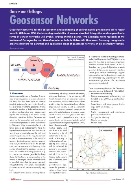
Figure 1: principle of cooperative<br />
adaptation of W-R-relationships<br />
al researchers and for different applications.<br />
Laube, Duckham & Wolle (2008) describe an<br />
algorithm to detect a moving point pattern,<br />
namely a so-called flock pattern. A flock is<br />
described as a group of objects that moves in<br />
a certain distance over a certain time. In a<br />
similar spirit, Laube & Duckham (2009) present<br />
a method for the detection of clusters in<br />
a decentralized way. Depending on the communication<br />
range, clusters of a certain size<br />
(radius) can be detected.<br />
There are many applications for Geosensor<br />
networks, see, e.g. Stefanidis & Nittel (2005):<br />
- Environmental monitoring<br />
- Disaster management, early warning systems<br />
(Bill et al., 2008), e.g. earthquakes,<br />
hill slides, …<br />
- Surveillance, risk management (buildings,<br />
technical devices, …)<br />
- Military<br />
- Traffic management and monitoring<br />
(car2car-communication)<br />
- Topographic Mapping<br />
- Glacier movements<br />
- Human body<br />
Figure 2: Quality of rainfall measurement.<br />
October/November <strong>2011</strong>