

2011 - Geoinformatics
2011 - Geoinformatics
2011 - Geoinformatics

Create successful ePaper yourself
Turn your PDF publications into a flip-book with our unique Google optimized e-Paper software.
A r t i c l e<br />
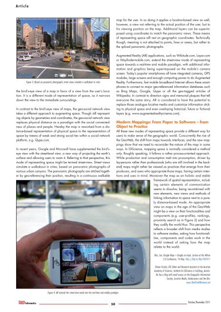
Figure 3: Based on panoramic photographs street views simulate a walkabout in cities<br />
the bird’s-eye view of a map in favor of a view from the user’s location.<br />
It is a different mode of representation of space, as it narrows<br />
down the view to the immediate surroundings.<br />
In contrast to the bird’s-eye view of maps, the geo-social network view<br />
takes a different approach to augmenting space. Though still representing<br />
objects by geometries and coordinates, the geo-social network view<br />
replaces physical distance as a paradigm with the social connectedness<br />
of places and people. Hereby the map is reworked from a distance-based<br />
representation of physical space to the representation of<br />
space by means of weak and strong social ties within a social network<br />
platform, e.g. Qype.com.<br />
In recent years, Google and Microsoft have supplemented the bird’seye<br />
view with the street-level view, a new way of projecting the earth’s<br />
surface and allowing users to roam it. Referring to that perspective, this<br />
mode of representing space might be termed street-view. Street views<br />
simulate a walkabout in cities, based on panoramic photographs of<br />
various urban canyons. The panoramic photographs are stitched together<br />
by geo-referencing their position, resulting in a continuous walkable<br />
Figure 4: AR extends the street-view mode into the real-time and mobile paradigm<br />
50<br />
map for the user. In so doing it applies a location-based view as well,<br />
however, a view not referring to the actual position of the user, but to<br />
his viewing position on the map. Additional layers can be superimposed<br />
using coordinates to match the panoramic views. These means<br />
of representing space still rest on geographic coordinates. Technically<br />
though, meaning is not attached to points, lines or areas, but rather to<br />
the spliced panoramic photographs.<br />
Augmented Reality (AR) applications, such as Wikitude.com, Layar.com<br />
or Wayfindermobile.com, extend the street-view mode of representing<br />
space towards a real-time and mobile paradigm, with additional information<br />
and graphics being superimposed on the mobile’s camera<br />
screen. Today’s popular smartphones all have integrated cameras, GPS<br />
modules, large screens and enough computing power to do Augmented<br />
Reality. Furthermore, fast mobile broadband Internet allows these smartphones<br />
to connect to major geo-referenced information databases such<br />
as Bing Maps, Google, Qype or all the geo-tagged articles of<br />
Wikipedia. In contrast to direction signs and memorial plaques that tell<br />
everyone the same story, AR is considered to have the potential to<br />
replace those analogue locative media and customize information sticking<br />
to physical space and even overlaying historical, future or fictional<br />
layers (e.g. www.augmentedrealitycinema.com).<br />
Modern Mappings: From Paper to Software – from<br />
Object to Practice<br />
All these new modes of representing space provide a different way for<br />
users to make sense of the geographic world. Concurrently the rise of<br />
the GeoWeb, the shift from maps towards interfaces, and the new mappings<br />
show that we need to reconsider the nature of the map in some<br />
ways. In GIScience, mapping space is normally considered a method<br />
only. Roughly speaking, it follows a rather process-oriented approach.<br />
While production and consumption melt into prosumption, driven by<br />
lay-persons rather than professionals (who are still involved in the backend)<br />
maps might rather be viewed as practices that emerge from their<br />
producers, and users who appropriate those maps, having certain intentions<br />
and uses in mind. Moreover the map as an holistic and stable<br />
framework of spatial representation, including<br />
certain elements of communication<br />
seems to dissolve, being recombined with<br />
new elements, new views and methods of<br />
linking information to space next to a purely<br />
distance-based mode. An appropriate<br />
view on maps in the age of the GeoWeb<br />
might be a view on their functionalities and<br />
components (e.g. user-profiles, rankings,<br />
proximity search as in Figure 2) and how<br />
they codify the world thus. This perspective<br />
reflects a broader shift from media studies<br />
to software studies, asking how functionalities,<br />
components and codes work in the<br />
world instead of asking how the map<br />
relates to the world.<br />
Ron, Lior: Google Maps = Google on maps. Lecture at the Where<br />
2.0 Conference, 14 May: http://blip.tv/file/969411<br />
Florian Fischer, GIS Editor and Research Assistant at the Austrian<br />
Academy of Sciences, Institute for GIScience in Salzburg, Austria.<br />
He has a blog with small essays on the Geographic Information<br />
Society, Locative Media, Geobrowsers and the like:<br />
www.ThePointOfInterest.net<br />
October/November <strong>2011</strong>