

Western Port Recreational Boating Guide. - Parks Victoria
Western Port Recreational Boating Guide. - Parks Victoria
Western Port Recreational Boating Guide. - Parks Victoria

Create successful ePaper yourself
Turn your PDF publications into a flip-book with our unique Google optimized e-Paper software.
A<br />
B<br />
C<br />
D<br />
E<br />
F<br />
G<br />
H<br />
I<br />
J<br />
K<br />
L<br />
M<br />
N<br />
O<br />
P<br />
Q<br />
R<br />
S<br />
T<br />
U<br />
V<br />
W<br />
Legend<br />
1 2 3 4 5 6 7 8 9 10 11 12 13 14 15 16 17 18 19 20 21 22 23 24 25 26 27 28 29 30 31 32<br />
38°25’<br />
38º28’47”S<br />
145º00’48”E<br />
38º28’59”S<br />
145º01’10”E<br />
STONY POINT<br />
Mgrvs<br />
FLINDERS<br />
38°30’<br />
SEE INSET<br />
Exposed at Low Water<br />
Water between 0m and 2m deep<br />
Water between 2m and 5m deep<br />
Water between 5m and 10m deep<br />
Water between 10m and 15m deep<br />
Water 15m and above<br />
Rocks<br />
R E D H I L L R O A D<br />
NO PERSONAL<br />
WATERCRAFT<br />
Q(4)Y12s<br />
Mud<br />
S T O N Y P O I N T R O A D<br />
Railway<br />
T R A C K<br />
Car<br />
Park<br />
Q(4)Y12s<br />
Oc.WRG4s<br />
5 Knot Zone<br />
No <strong>Boating</strong><br />
No Personal Water Craft<br />
No Personal Water Craft or Sailboards<br />
Access Lane<br />
Depot<br />
TANKERTON<br />
FI.G5s<br />
Mgrvs<br />
Restricted Water and limited access<br />
Marine National Park / Marine Sanctuary<br />
National Park and Conservation Areas<br />
145° 05’ 145° 10‘<br />
F R A N K S T O N – F L I N D ER S R O A D<br />
AQUACULTURE<br />
West Head<br />
38º29’28”S<br />
145º00’47”E<br />
38º29’29”S<br />
145º01’10”E<br />
Mushroom Reef<br />
Marine Sanctuary<br />
Flinders Rock<br />
Y<br />
Y<br />
F L I N D E R S<br />
B I G H T<br />
Q(4)Y12s<br />
Fl.Y5s<br />
Q(4)Y12s<br />
Y Y<br />
H A S T I N G S P O R T L I M I T<br />
R<br />
Jetty<br />
Mud<br />
R R<br />
G<br />
Q(4)Y12s<br />
Q(4)Y12s<br />
ENCLOSED WATERS<br />
COASTAL WATERS<br />
Piles<br />
G<br />
G<br />
Honeysuckle<br />
Point<br />
38°15’<br />
B A L N A R R I N G R O A D<br />
B I T T E R N – D R O M A N A R O A D<br />
PT LEO<br />
B A L N A R R I N G<br />
BALNARRING<br />
Palmer Bluff<br />
Merricks Beach<br />
Round Island<br />
Fl.WR7s<br />
Seal Rocks<br />
Black Rock<br />
LIGHTS<br />
Boat Ramp<br />
Fuel<br />
38°20’<br />
145° 05’ 145° 10‘<br />
B E A C H R D<br />
F R A N K S T O N – F L I N D E R S R O A D<br />
Pump out facitity<br />
Important bird roosting sites – do not disturb R<br />
Beacon or Conspicuous Mark<br />
No fishing, netting, spearing, taking or<br />
killing of marine life. All methods of fishing,<br />
from the shore or at sea, are prohibited<br />
Indicates a light structure or a lit beacon<br />
Iso. Isophase Fl. Flashing<br />
Oc. Occulating Q. Quick Flashing<br />
F. Fixed VQ. Very Quick Flashing<br />
eg. Fl.(2)8s A group of 2 flashes every 8 seconds<br />
G Green R Red W White Y Yellow Bl Blue<br />
Mo Morse Code<br />
C O O L A R T R O A D<br />
S A N D Y P O I N T R O A D<br />
L O R D<br />
YBY<br />
Q(4)Y10s YB<br />
BY BYB<br />
R<br />
BYB<br />
G<br />
YB<br />
W E S T E R N<br />
P A R K S V I C T O R I A<br />
Y Fl.Y4s<br />
F.Bu<br />
G<br />
Y Y<br />
G<br />
K I L O M E T R E S<br />
N A U T I C A L M I L E S<br />
P A R K S<br />
V I C T O R I A<br />
P O R T L I M I T<br />
W E S T E R N<br />
BREAKS IN HEAVY WEATHER<br />
Fairway<br />
Buoy<br />
RW Iso.2s<br />
LEADING LIGHTS 288º00'<br />
R<br />
SCALE 1:10,000<br />
Jetty<br />
F.Bu<br />
Mud<br />
T E A T R E E P O I N T<br />
K I L O M E T R E S<br />
N A U T I C A L M I L E S<br />
SCALE 1:10,000<br />
Fl.(2)R8s<br />
Point Sambell<br />
The Nobbies<br />
Point Grant<br />
COOLART<br />
WETLANDS<br />
AND<br />
HOMESTEAD<br />
H A S T I N G S P O R T L I M I T<br />
No.2<br />
R<br />
No.1<br />
G<br />
Salt<br />
Marsh<br />
TA N K E R T O N<br />
R O A D<br />
FRENCH<br />
ISLAND<br />
No.6<br />
R No.5<br />
G<br />
C A T B A Y<br />
S O M E R S R D<br />
SOMERS<br />
Phelan Bluff<br />
SEE INSET<br />
No.8<br />
R<br />
No.7<br />
YBY<br />
F R A N K S T O N – F L I N D E R S R O A D<br />
HASTINGS<br />
McHaffie Reef<br />
Fl.WRG5s<br />
McHaffie Point<br />
BLACK HILL 68m<br />
S W A N L A K E<br />
Kitty Miller Bay<br />
HMAS Cerberus<br />
Watt Point<br />
Helen Head<br />
B A S S<br />
S T O N Y P O I N T R D<br />
SEE INSET<br />
T YA B B – T O O R A D I N R O A D<br />
MARKS<br />
Y Y Y<br />
G<br />
R<br />
G<br />
BY BY YB YB BYB BYB YBY YBY<br />
North South East West<br />
BRB<br />
145° 15’<br />
B A X T E R – T O O R A D I N R O A D B A X T E R – T O O R A D IN R O A D<br />
H A N N S<br />
D A N D E N O N G – H A S T I N G S R O A D ( W E S T E R N P O R T H W Y )<br />
STEEL<br />
CRIB POINT<br />
I N L E T<br />
Restricted<br />
Area<br />
Water Tower<br />
No.12<br />
R<br />
STONY<br />
POINT<br />
Red Rock Point<br />
Penguin Rock<br />
ACCESS LANE<br />
S a l t w a t e r C r e e k<br />
YARINGA<br />
SEE INSET<br />
R<br />
Fl(2).R8s<br />
Fl.R<br />
G<br />
No.22<br />
No.21<br />
SEE<br />
INSET<br />
Fl.R10s<br />
COWES<br />
P H I L L I P I S L A N D<br />
Redcliff Head<br />
Chimney<br />
SANDSTONE IS.<br />
P A S S A G E<br />
Berry Beach<br />
ex-HMAS Otama<br />
(submarine)<br />
Sandy Point<br />
P H I L L I P I S L A N D R D<br />
RICHARDSON HILL 68m<br />
Pyramid Rock<br />
38º14’50”S<br />
145º14’55”E<br />
N O R T H<br />
Ld’g LIGHTS<br />
320º39'<br />
H A S T I N G S<br />
P O R T L I M I T<br />
INDUSTRY<br />
WHARVES<br />
NO<br />
BOATING<br />
H A S T I N G S<br />
Long Is.<br />
WESTERN PORT<br />
Point<br />
MARINA<br />
R<br />
B I G H T<br />
G<br />
No.35<br />
G<br />
No.33 Fl(2)Y.5s<br />
G<br />
No.32<br />
F.R R<br />
Fl.Y3s<br />
No.31<br />
F.R G<br />
F.R<br />
G<br />
Fl.Y4s<br />
No.30<br />
No.29<br />
No.11<br />
G<br />
Fl.G<br />
Q.R<br />
Fl.5s<br />
NO<br />
BOATING<br />
F.Bu<br />
F.Bu<br />
F<br />
No.14<br />
R<br />
No.13<br />
BY<br />
Fl.R2s<br />
G<br />
No.28 No.27<br />
R G Fl.Y4s<br />
No.26 No.25<br />
F.R R G<br />
No.18<br />
R R<br />
R<br />
G<br />
G No.23<br />
No.24 Fl(4)Y.6s<br />
R<br />
Radio Tower<br />
Cunningham Bay<br />
145° 15’<br />
Special<br />
<strong>Port</strong> hand – even numbers<br />
Starboard hand – odd numbers<br />
Isolated Danger (Black and Red)<br />
Cardinal – Pile or Pillar Buoy<br />
(Yellow and Black) with<br />
appropriate black top mark<br />
Marine National Park boundary markers (land)<br />
Access Lane<br />
Ld’g LIGHTS<br />
288º00'<br />
No.19<br />
No.20<br />
Fl.G R YBY<br />
No.16<br />
No.15<br />
R G<br />
A R M<br />
No.17<br />
YBY<br />
VQ(9)10s<br />
YBY<br />
W A T S O N<br />
Yaringa<br />
Marine National Park<br />
R<br />
R<br />
R<br />
C H A N N E L<br />
R R<br />
Middle<br />
Spit<br />
M I D D L E<br />
G<br />
R<br />
S P I T<br />
W AT S O N<br />
F.Bu<br />
SEE INSET<br />
SHIPPING<br />
ANCHORAGE<br />
Sunderland<br />
Bluff<br />
I N L E T<br />
C H A N N E L<br />
Tortoise Head<br />
H A S T I N G S P O R T L I M I T<br />
ACCESS LANE<br />
G<br />
YB<br />
Q(6)Fl.15s<br />
Fl.G8s<br />
R<br />
R H Y L L – N E W H AV E N R O A D<br />
Sunderland Bay<br />
QUAIL ISLAND<br />
S W A N C O R N E R<br />
1 2 3 4 5 6 7 8 9 10 11 12 13 14 15 16 17 18 19 20 21 22 23 24 25 26 27 28 29 30 31 32<br />
River Point<br />
R E D B I L L<br />
SEE INSET<br />
CANNONS<br />
38º12’47”S<br />
145º18’10”E CREEK<br />
SEE INSET<br />
FAIRHAVEN<br />
TANKERTON<br />
Tortoise Head<br />
Bank<br />
S T R A I T<br />
C R E E K<br />
R U T H E R F O R D<br />
I N L E T<br />
38º17’00”S<br />
145º18’30”E<br />
RHYLL<br />
38º29’09”S<br />
145º18’20”E<br />
Chinaman Is.<br />
B L A K E S C H A N N E L<br />
P A R K S<br />
V I C T O R I A<br />
Observation Point<br />
Fl.G5s<br />
SEE INSET<br />
Long Point<br />
P H I L L I P I S L A N D R O A D<br />
145° 20’<br />
WARNEET<br />
Adams Point<br />
G E N T L E<br />
Fl.R3s<br />
R<br />
G<br />
SEE INSET<br />
Eagle Rock<br />
B A G G E<br />
Fl.G5s<br />
YBY<br />
Fl.(2)10s<br />
H A R B O U R<br />
R<br />
R<br />
Crawfish Rock<br />
YBY<br />
Fl.WRG8s 38º16’24”S<br />
P A R K S<br />
V I C T O R I A<br />
G<br />
BY<br />
145º18’45”E<br />
Y<br />
G Barralliar Is.<br />
Scrub Point NO LANDING<br />
G<br />
R<br />
Y<br />
Q.G<br />
Y<br />
Y<br />
R<br />
G<br />
G<br />
R<br />
THE PINNACLES 66m<br />
Fl.R10s<br />
The Colonnades<br />
SEE INSET<br />
145° 20’<br />
S O U T H G I P P S L A N D H W Y S O U T H G I P P S L A N D H W Y<br />
F R E N C H<br />
38º29’37”S<br />
145º20’16”E<br />
CHURCHILL IS.<br />
NEWHAVEN<br />
SEE INSET<br />
Fl.10s<br />
I S L A N D<br />
F R E N C H I S L A N D<br />
Peck Point<br />
BY<br />
Churchill Island<br />
Marine National Park<br />
T O O R A D I N<br />
C H I C O R Y L A N E<br />
Y<br />
R<br />
R<br />
Woolamai Waters<br />
Manuka Point<br />
Woolamai Beach<br />
G<br />
G<br />
➤<br />
Ram Island<br />
B L I N D B I G H T<br />
A N N I E<br />
R<br />
TO CRANBOURNE<br />
Y<br />
C H A N N E L<br />
R<br />
Joes Island<br />
YBY BYB<br />
YBY<br />
MT WELLINGTON 98m<br />
F.Bl<br />
F.Bl<br />
R<br />
R<br />
G<br />
I R I S H<br />
French Island<br />
Marine National Park<br />
HARROP HILL 98m<br />
McLeod<br />
Point<br />
Red Point<br />
C H A N N E L<br />
R<br />
G<br />
R R<br />
G YBY<br />
C H A R I N G<br />
Charing<br />
BRB Cross<br />
Island<br />
Fl.G2s<br />
Q.G<br />
Nº2<br />
Fl.R3s<br />
C H A N N E L<br />
S A W T E L L S I N L E T<br />
J A C K<br />
38º17’33”S<br />
145º22’06”E<br />
Y<br />
R<br />
R<br />
R<br />
P O S T O F F I C E<br />
Y<br />
Fl.2s<br />
ELIZABETH IS.<br />
R<br />
E A S T<br />
R<br />
C R O S S<br />
F.G<br />
Davis Point<br />
Cape Woolamai<br />
C O C K YA N E S<br />
TOORADIN<br />
SEE INSET<br />
SAN REMO<br />
Griffith Point<br />
I N S I D E<br />
C H A N N E L<br />
LYA L L S<br />
38º17’07”S<br />
145º23’12”E<br />
G Y<br />
Maggie Shoal<br />
145° 25’<br />
Pelican Point<br />
N A T I O N A L<br />
Schnapper<br />
Rock<br />
YB<br />
Iso.G2s<br />
Pelican Island<br />
SettlementPoint<br />
Elizabeth Bluff<br />
P O R T<br />
E A S T E R N E N T R A N C E<br />
P A R K S<br />
V I C T O R I A<br />
P O R T L I M I T<br />
R<br />
R YBY<br />
Fl.G10s<br />
Loelia Shoal<br />
BYB<br />
YBY<br />
R<br />
R<br />
Fl.G8s<br />
R<br />
Fl.R10s<br />
ENCLOSED WATERS<br />
COASTAL WATERS<br />
B O U C H I E R<br />
French Island<br />
Marine National Park<br />
YBY<br />
YBY<br />
T H E D U C K S P L A S H<br />
R<br />
Reef Island<br />
Punch Bowl<br />
L E A D I N G L I G H T S 3 0 6 º 0 4 '<br />
B O U LT O N<br />
38º16’46”S<br />
145º25’10”E<br />
Y<br />
C H A N N E L<br />
R<br />
A R M<br />
Fl.R5s<br />
C O R O N E T B A Y<br />
145° 25’<br />
C H A N N E L<br />
H O R S E S H O E<br />
BRB<br />
F.G<br />
C A R D I N I A C R E E K<br />
T H E I N L E T S<br />
P A R K<br />
R<br />
McLEODS<br />
CORINELLA<br />
Cobb Bluff<br />
M O O D Y ’ S I N L E T<br />
C H A N N E L<br />
C H A N N E L<br />
C H A N N E L<br />
38º17’34”S<br />
145º27’15”E<br />
R<br />
G U Y S<br />
C H A N N E L<br />
38º18’24”S<br />
145º27’12”E<br />
B A S S<br />
Palmer Point<br />
Freeman Point<br />
270 280 290 300 310 320 330 340 350<br />
250<br />
R I V E R<br />
ANDERSON HILL 155m<br />
260<br />
Y<br />
YBY<br />
240<br />
H E A L S V I L L E –<br />
SEE INSET<br />
Blue Gum Point<br />
B A S S H W Y B A S S H W Y<br />
Black Head<br />
B U N Y I P R I V E R<br />
230<br />
COOLART WETLANDS<br />
AND HOMESTEAD<br />
R<br />
220<br />
K O O W E E R U P R O A D<br />
145° 30’<br />
TO KOO WEE RUP NORTH ➤<br />
KOO WEE RUP<br />
210<br />
Y<br />
200<br />
Y A L L O C K C R E E K<br />
Spit Point<br />
Tenby Point<br />
190<br />
QUEENSFERRY<br />
MAGNETIC NORTH 11º30'E 2009 (1'E)<br />
KILCUNDA<br />
B A S S H W Y<br />
145° 30’<br />
Tower<br />
L A N G L A N G R I V E R<br />
Bluff Point<br />
Stockyard Point<br />
P O W L E T T R I V E R<br />
38°15’<br />
LANG LANG<br />
B A S S H W Y<br />
38°20’<br />
GRANTVILLE<br />
0 10 20 30 40 50 60 70 80 90<br />
TRUE NORTH<br />
180<br />
Y<br />
170 160 150 140 130 120 110 100<br />
38°25’<br />
38°30’<br />
TO WONTHAGGI ➤<br />
BALNARRING SOMERS<br />
Groynes<br />
Yacht Club<br />
L E A D I N G L I N E 0 6 7 º<br />
R<br />
Q(4)Y.10s<br />
BY<br />
YB<br />
Merricks Merricks Creek Creek<br />
L E A D I N G L I N E 3 2 7 º 3 0 ’<br />
BYB<br />
YBY<br />
YB<br />
G<br />
Groynes<br />
BYB<br />
Yacht<br />
Club<br />
K I L O M E T R E S<br />
N A U T I C A L M I L E S<br />
SCALE 1:25,000<br />
W<br />
A<br />
B<br />
C<br />
D<br />
E<br />
F<br />
G<br />
H<br />
I<br />
J<br />
K<br />
L<br />
M<br />
N<br />
O<br />
P<br />
Q<br />
R<br />
S<br />
T<br />
U<br />
V<br />
NEWHAVEN<br />
C L E E L A N D S T R E E T<br />
C O W E S – S A N R E M O R D<br />
Sand<br />
M A R I N E P D E<br />
H E R R I N G S T<br />
S K I N N E R S T<br />
W O O L A M A I<br />
HASTINGS<br />
Marina<br />
Centre<br />
M U L L E T S T<br />
Rock<br />
Yacht<br />
Club<br />
Jetty<br />
F O R R E S T S T R E E T<br />
A N D E R S O N S T R E E T<br />
B E A C H C R E S C E N T<br />
Mud<br />
R<br />
Mud<br />
Breakwater<br />
M A R I N A<br />
W E S T E R N P O R T<br />
M A R I N A<br />
OC.5s<br />
S E AV I E W S T R E E T<br />
Q<br />
Suspended Transmission Cables<br />
R<br />
Mud<br />
CAUTION – NARROWS BETWEEN NEWHAVEN AND SAN REMO<br />
Boaters beware an 18-metre high headway under overhead power cables, and 12-metre headway<br />
under the bridge between San Remo and Newhaven prevents the passage of boats unless masts<br />
can be unstepped.<br />
Strong tidal flow reaching up to 6 knots exists at the narrows between Newhaven and San Remo.<br />
Because of the large rise and fall in tide on <strong>Western</strong> <strong>Port</strong>, it is advised boat operators remain in<br />
defined channels as boats have been stranded on mud flats for upwards of eight hours.<br />
F.R<br />
Marina<br />
Services<br />
G<br />
Y<br />
Y<br />
Report illegal fishing<br />
call 13 FISH (☎13 3474)<br />
B E A C H<br />
Helpful information includes:<br />
♦ Time and date<br />
of activity<br />
♦ Place<br />
♦ Number of<br />
people involved<br />
P H I L L I P ISLAND R O A D<br />
WOOLAMAI<br />
WATERS<br />
F.Bl<br />
H O M E S T E A D P O I N T<br />
Short-term<br />
public access<br />
moorings<br />
R O A D<br />
F.Bl<br />
Sand<br />
S T A T E<br />
Surf Lifesaving<br />
Club<br />
♦ Vehicle/boat<br />
registration<br />
♦ Activity<br />
♦ Equipment<br />
Information provided will assist in planning<br />
patrols and enforcement operations when no<br />
immediate field response is possible.<br />
K I L O M E T R E S<br />
N A U T I C A L M I L E S<br />
SCALE 1:25,000<br />
G<br />
R<br />
BYB<br />
G<br />
M A N U K A P O I N T<br />
Q.G<br />
Q.R<br />
Mooring<br />
Piles<br />
Fl.G2s<br />
C L E E L A N D<br />
F A U N A L<br />
B I G H T<br />
Fl.R3s<br />
F.G<br />
Jetty<br />
Q.G<br />
R<br />
B L A C K R E E F<br />
BRB<br />
BY<br />
R<br />
Fl(2)5s<br />
Turbine<br />
Bridge<br />
Jetty<br />
G<br />
Sand<br />
CAUTION – NARROWS BETWEEN NEWHAVEN AND SAN REMO<br />
Boaters beware an 18-metre high headway under overhead power cables, and 12-metre headway<br />
under the bridge between San Remo and Newhaven prevents the passage of boats unless masts<br />
can be unstepped.<br />
Strong tidal flow reaching up to 6 knots exists at the narrows between Newhaven and San Remo.<br />
Because of the large rise and fall in tide on <strong>Western</strong> <strong>Port</strong>, it is advised boat operators remain in<br />
defined channels as boats have been stranded on mud flats for upwards of eight hours.<br />
M A R I N E<br />
W O O L A M A I G R O V E<br />
FI.R6s<br />
G<br />
Mud<br />
YBY<br />
Mud<br />
G<br />
K I L O M E T R E S<br />
3 0 7 . 4 º<br />
N A R R O W S<br />
FI.G3s<br />
N A U T I C A L M I L E S<br />
SCALE 1:10,000<br />
T H E N A R R O W S<br />
M I D D L E<br />
S A N D<br />
Trmn Lines<br />
R<br />
Bridge<br />
F.G<br />
Mud<br />
and<br />
Rocks<br />
PA R A D E<br />
H A Z E LW O O D G R O V E<br />
B E R G I N G R O V E<br />
R<br />
V.Q<br />
BY<br />
R<br />
Pier<br />
R<br />
Y<br />
R<br />
H A S T I N G S<br />
R<br />
R<br />
G<br />
D A V I S P O I N T<br />
Slipway<br />
Y<br />
R<br />
R<br />
G<br />
FI.G3s<br />
SAN REMO<br />
Sand<br />
E A S T E R N E N T R A N C E<br />
L E A D I N G L I G H T S 306º04'<br />
G R I F F I T H P O I N T<br />
G<br />
Q.R<br />
B A C K B E A C H R O A D<br />
CAPE WOOLAMAI<br />
Fl.G8s<br />
G<br />
Mud<br />
G<br />
G<br />
K I L O M E T R E S<br />
N A U T I C A L M I L E S<br />
SCALE 1:10,000<br />
SAN REMO<br />
H U M B U G R E A C H<br />
YBY<br />
V.Q(9)10s<br />
G<br />
Q.R<br />
S A N D S T O N E<br />
I S L A N D<br />
B A C K B E A C H R O A D<br />
Q.G<br />
Rocks<br />
Mud<br />
and<br />
Rocks<br />
T O U R I S T R O A D<br />
BB LL II NN D D LL EE AA DD<br />
R<br />
H A S T I N G S<br />
C H A N N E L<br />
FRENCH ISLAND<br />
Mud<br />
Point Leuschnault<br />
Barge Landing<br />
S T O C K Y A R D<br />
P O I N T<br />
Mud<br />
K I L O M E T R E S<br />
N A U T I C A L M I L E S<br />
SCALE 1:25,000<br />
B I G H T<br />
E A S T<br />
YARINGA<br />
K ATA N D R A R D<br />
YA R I N G A R D<br />
Mangroves<br />
R<br />
YB<br />
B U N G O W E R R O A D<br />
L U M E A H R D<br />
K I L O M E T R E S<br />
N A U T I C A L M I L E S<br />
SCALE 1:25,000<br />
Mangroves<br />
R<br />
FI.R2s<br />
S C H N A P P E R<br />
R O C K S<br />
Mud<br />
Iso.G2s<br />
P E L I C A N<br />
I S L A N D<br />
Mangroves<br />
L O N G I S L A N D P O I N T<br />
L I Q U I D S P I E R<br />
L O N G<br />
I S L A N D<br />
P O I N T<br />
Entrance Beacon<br />
FI.5s<br />
( P R I V A T E )<br />
Y A R I N G A B O A T H A R B O U R<br />
F.R<br />
A R M<br />
G<br />
G<br />
S E T T L E M E N T<br />
P O I N T<br />
R R<br />
Y A R I N G A C H A N N E L<br />
Mud<br />
FI.R3s<br />
R<br />
FI.R5s<br />
Fl.Y4s<br />
Mud<br />
CORINELLA<br />
G<br />
G<br />
R<br />
G<br />
R<br />
Mud<br />
Fl.Y4s<br />
F.G<br />
Jetty<br />
Mud<br />
W A T S O N<br />
Y<br />
Yaringa<br />
Marine<br />
National<br />
Park<br />
I N L E T<br />
F.R<br />
F.R<br />
N O R T H A R M<br />
F.G<br />
F.G<br />
RHYLL<br />
J A N S S O N S T R E E T<br />
WA R L E Y AV E N U E<br />
L O C H R O A D<br />
Jetty<br />
Rock<br />
B E A C H C R E S C E N T<br />
Car<br />
Park<br />
COWES<br />
T H O M P S O N AV E N U E<br />
Jetty<br />
Fl.R10s E R E H W O N<br />
P O I N T<br />
T H E E S P L A N A D E<br />
B A S S AV E N U E<br />
NO BOATING<br />
Sand<br />
C H A P E L S T R E E T<br />
Slip<br />
Fl.G5s<br />
Sand<br />
Careening Piles<br />
K I L O M E T R E S 0.4<br />
N A U T I C A L M I L E S<br />
SCALE 1:10,000<br />
Yacht<br />
Club<br />
Mud<br />
G<br />
K I L O M E T R E S 0.4<br />
N A U T I C A L M I L E S<br />
SCALE 1:10,000<br />
R<br />
Jetty<br />
Oc.WRG4s<br />
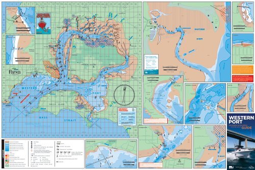
MARIne nATIOnAL PARK COORdInATeS<br />
0.2<br />
FLINDERS<br />
F I N D L E Y S T R E E T<br />
G<br />
Mud<br />
Yacht Club<br />
Latitude and Longitude values are based on WGS84.<br />
GPS users note that co-ordinates for boundaries are<br />
given in the format degrees:minutes:seconds. Alternate<br />
formates are available on www.parks.vic.gov.au, by<br />
calling 13 1963, or from <strong>Parks</strong> <strong>Victoria</strong> Offices. Location<br />
of reefs are for illustrative purposes only and may not<br />
indicate true position.<br />
nOTe: THIS IS nOT A nAVIgATIOn CHART<br />
This map is not for navigation use. Navigation aids are<br />
shown for information only. For navigation of <strong>Western</strong><br />
<strong>Port</strong>, Charts AUS 150, AUS 151 and AUS 152 should be<br />
consulted. Notices to Mariners issued by <strong>Parks</strong> <strong>Victoria</strong><br />
are published on www.parks.vic.gov.au<br />
0.2<br />
Fl.R10s<br />
S T E E L E S T R E E T<br />
K I L O M E T R E S 0.4<br />
N A U T I C A L M I L E S<br />
SCALE 1:10,000<br />
WESTERN<br />
PORT<br />
recreational boating<br />
5TH EDITION, JUNE 2011<br />
GUIDE<br />
0.2
<strong>Western</strong> <strong>Port</strong> is a treasure trove full of<br />
wonderful marine life and plenty of<br />
opportunities to explore. There’s a lot to<br />
see and do both on and under the water<br />
including watching wildlife, fishing, boating,<br />
kite boarding, diving, swimming or taking<br />
a stroll along a pier.<br />
Encounter dolphins and seals in their<br />
natural habitat<br />
As you travel across the bay, be on the lookout for dolphins or<br />
seals. Dolphins tend to be seen more often at the southern end of<br />
<strong>Western</strong> <strong>Port</strong> while seals can be seen soaking up the sun at Seal<br />
Rocks. Remember to keep a safe distance from wildlife at all times.<br />
Explore amazing underwater marine life<br />
<strong>Western</strong> <strong>Port</strong> is home to three Marine National <strong>Parks</strong> which host<br />
diverse marine life not seen anywhere else in the world and provide<br />
a variety of snorkelling and diving opportunities. See Marine<br />
National <strong>Parks</strong> section in alphabetical listing for further details.<br />
Hook a fishing adventure<br />
One of the most popular activities in <strong>Western</strong> <strong>Port</strong> is fishing.<br />
Anglers are lured by the thrill of the chase and catch a range of<br />
fish including flathead, snapper, squid, leatherjacket, gummy<br />
shark, salmon or King George whiting.<br />
Watch <strong>Western</strong> <strong>Port</strong>’s international visitors<br />
Bird watching is a popular and rewarding pastime and <strong>Western</strong><br />
<strong>Port</strong> provides excellent opportunities for observing a great variety<br />
of waterbirds. Of particular note are the flocks of migratory<br />
waders that use <strong>Western</strong> <strong>Port</strong> as a rich feeding area prior to<br />
their departure for breeding grounds within the Arctic Circle.<br />
Significant populations of species such as the Eastern Curlew,<br />
Whimbrel and Bar-tailed Godwit make their home in <strong>Western</strong> <strong>Port</strong><br />
between September and April each year.<br />
Licensed tour operators<br />
Take the easy approach to organising your great bay adventures<br />
by booking a tour, dive or fishing trip with one of <strong>Parks</strong><br />
<strong>Victoria</strong>’s licensed tour operators. For more information contact<br />
<strong>Parks</strong> <strong>Victoria</strong>.<br />
explore<br />
western port<br />
western port<br />
<strong>Western</strong> <strong>Port</strong> directory<br />
EMERGENCY 000 or 27MHz – Ch 88 or VHF – Ch 16<br />
Australian Hydrographic Service 02 4223 6500<br />
www.hydro.gov.au<br />
Australian Volunteer Coast Guard 9598 9092<br />
www.coastguard.com.au<br />
Bureau of Meteorology 9669 4000<br />
www.bom.gov.au<br />
Dept. of Primary Industries 136 186<br />
www.dpi.vic.gov.au<br />
Dept. of Sustainability & Environment 136 186<br />
www.dse.vic.gov.au<br />
Environment Protection Authority 9695 2722<br />
www.epa.vic.gov.au<br />
Fisheries <strong>Victoria</strong> 136 186<br />
Report Illegal Fishing 13 FISH (13 3474)<br />
www.dpi.vic.gov.au/fishing<br />
Government Information Centre 1300 366 356<br />
www.vic.gov.au<br />
Heritage <strong>Victoria</strong> 8644 8800<br />
www.heritage.vic.gov.au<br />
<strong>Parks</strong> <strong>Victoria</strong> 13 1963<br />
www.parks.vic.gov.au<br />
<strong>Port</strong> of Hastings www.portofhastings.vic.gov.au<br />
<strong>Port</strong> of Melbourne Corporation 1300 857 662<br />
www.portofmelbourne.com<br />
Transport Safety <strong>Victoria</strong> 1800 223 022<br />
www.transportsafety.vic.gov.au<br />
<strong>Victoria</strong>n Regional Channels Authority 5225 3500<br />
www.regionalchannels.vic.gov.au<br />
<strong>Victoria</strong>n Water Police 9399 7500<br />
<strong>Western</strong> <strong>Port</strong> Marina 5979 7400<br />
www.westernportmarina.com.au<br />
Yaringa Marina 5977 4154<br />
www.yaringa.com.au<br />
boating and swimming<br />
zone review<br />
As the <strong>Port</strong> Manager for <strong>Port</strong> Phillip and <strong>Western</strong> <strong>Port</strong>, <strong>Parks</strong><br />
<strong>Victoria</strong> has conducted a thorough review of all zones across the<br />
bays to ensure optimum safety and efficiency for all users of our<br />
bays. This review has been conducted with extensive consultation<br />
of community groups and individuals and relevant organisations<br />
who have an interest in recreational activity on the bays. Revisions<br />
to the zones will be phased in over several years using improved<br />
aids to navigation and clearer signage. For the latest information<br />
on the <strong>Recreational</strong> <strong>Boating</strong> and Swimming Zone Review visit<br />
www.parks.vic.gov.au<br />
1. The majestic Australian Pelican is easy to<br />
spot in flight.<br />
2. The Bar tailed Godwit is one of many bird<br />
species that migrate to <strong>Western</strong> <strong>Port</strong>.<br />
3. Cowes Pier is a popular boating destination<br />
and departure point<br />
4. Cowes boat ramp is one of many boat ramps<br />
around <strong>Western</strong> <strong>Port</strong><br />
5. Marine National <strong>Parks</strong> are home to many<br />
species including the Spiny Globe Fish<br />
6. <strong>Western</strong> <strong>Port</strong> is great for family fishing<br />
adventures<br />
7. Sailing is popular in southern <strong>Western</strong> <strong>Port</strong><br />
8. San Remo Pier is home to <strong>Western</strong> <strong>Port</strong>’s<br />
fishing fleet<br />
9. Weedy Sea Dragons are common<br />
around Flinders<br />
Recommended Publications<br />
Admiralty charts<br />
Available from most mapping outlets<br />
The Marine Act and associated regulations<br />
Available from the Government Information Centre<br />
<strong>Port</strong> of Hastings Handbook<br />
Available from www.patrick.com.au<br />
<strong>Victoria</strong>n <strong>Recreational</strong> <strong>Boating</strong> Safety Handbook<br />
Available from Marine Safety <strong>Victoria</strong><br />
<strong>Victoria</strong>n Tide Tables<br />
Available from <strong>Port</strong> of Melbourne Corporation<br />
Vessel Operating and Zoning Rules<br />
Available from Transport Safety <strong>Victoria</strong><br />
Available from <strong>Parks</strong> <strong>Victoria</strong><br />
Notice to Mariners<br />
Available at www.parks.vic.gov.au<br />
PORT<br />
PHILLIP<br />
recreational boating<br />
6TH EDITION, JULY 2010<br />
GUIDE<br />
boating safety<br />
checklist<br />
Everyone on the water has a duty of care to<br />
maintain a proper lookout at all times. This<br />
duty includes proper handling of a vessel and<br />
observing the rules, knowing the limitations<br />
of the boat, being aware of potential hazards<br />
and allowing for the actions of others, both<br />
reasonable and unreasonable. Using the<br />
following checklist will help you have the best<br />
possible boating experience on <strong>Western</strong> <strong>Port</strong>:<br />
Be prepared before you leave:<br />
l Carry safety equipment according to the regulations, including<br />
approved PFD-1s otherwise known as life jackets.<br />
l All children under the age of 10 years must wear an approved<br />
PFD-1 while on a recreational boat that is under way, unless<br />
the child is within a deckhouse, cabin, half cabin or a secure<br />
enclosed space.<br />
l Have a chart of where you are going and a radio.<br />
l Tell someone where you are going and when you expect<br />
to return.<br />
l Know the rules, local regulations and distress signals.<br />
l Check out local conditions, weather and tides.<br />
l Carry sufficient fuel, water and a first aid kit.<br />
l Ensure engine reliability and adequate fuel system and always<br />
carry sufficient fuel.<br />
l Don’t overload your boat.<br />
On the water<br />
l Adhere to the prescribed speed limits.<br />
l Ensure you always keep to the right of channels.<br />
l Wear your life jackets.<br />
l Keep a careful watch on the weather and watch out for other<br />
boats and hazards.<br />
l Keep a safe distance between your boat and other boats,<br />
people, wildlife or structures.<br />
l Keep a lookout at all times, especially rowers or non powered<br />
craft who are generally harder to see and hear.<br />
l Ensure a low wake is maintained when passing rowers and<br />
other non powered vessels or floating infrastructure.<br />
l Never mix alcohol and operating a vessel.<br />
l Keep well clear of moving ships as they may alter course and<br />
without notice.<br />
l Do not obstruct the movement of large vessels by drifting in<br />
shipping channels and across shipping tracks.<br />
l Be aware that the bow-wave or wash from large ships, including<br />
the large commercial ferries, can cause your boat to capsize or<br />
roll heavily as to cause serious injury to its occupants.<br />
l Take care not to cross ahead of a large vessel as you may<br />
underestimate its speed and not be seen.<br />
l If you hear a vessel sounding at least five short and rapid blasts<br />
on its horn, you must get out of its way.<br />
l Navigation lights on your vessel must be shown at night<br />
Regulations to be observed<br />
The following regulations must be observed to protect the bay<br />
environment and ensure a level of safety for all users of the waters:<br />
l Immediately slow down to 5 knots around swimmers or divers.<br />
l Don’t exceed the speed limit.<br />
l Observe boat zone boundaries and restrictions.<br />
l Know the boundaries and restrictions of Marine National <strong>Parks</strong><br />
and Sanctuaries.<br />
l Take all rubbish home with you and dispose of it appropriately.<br />
l Remember all native plants and animals are protected by law.<br />
l Jumping or diving from piers, jetties or bridges is not permitted.<br />
l Vessel operators over 21 years of age must have a Blood<br />
Alcohol Concentration (BAC) of below 0.05. Vessel operators<br />
under 21 years of age or accompanying a restricted license<br />
holder must have a BAC of 0.<br />
l The discharge of sewerage and other waste from boats<br />
is prohibited.<br />
look after<br />
western port<br />
<strong>Western</strong> <strong>Port</strong> is an important feeding site for migratory waterbirds<br />
and is acknowledged in several international protection<br />
agreements. Boat operators have a responsibility to protect<br />
the marine environment and ensure it can be enjoyed by future<br />
generations. You can protect <strong>Western</strong> <strong>Port</strong> and minimise your<br />
environmental impact by following these simple guidelines:<br />
• Avoid anchoring over seagrass and reef areas and consider<br />
purchasing an anchor that does less damage to seabeds.<br />
• Keep your boat clean and protected from aquatic pests.<br />
• Reduce speed when operating power boats in shallow water<br />
or when close to shore as propellers can cause considerable<br />
damage to sensitive seabeds and the wake can cause erosion.<br />
• Prevent pollutants such as petrol, oil, sewage and detergents<br />
from entering the water.<br />
• Store rubbish securely on your boat and always take all rubbish<br />
home with you.<br />
• Dispose of sewerage waste properly and use pump out facilities<br />
where they are available.<br />
• Clean out bilges and sumps regularly.<br />
• Launch or retrieve your craft at designated launching ramps.<br />
• Observe recreational fishing regulations.<br />
• Avoid disturbing flocks of feeding, resting or breeding birds.<br />
Get involved with a marine friends group. Contact <strong>Parks</strong> <strong>Victoria</strong><br />
for more information.<br />
hoon<br />
boating laws<br />
boating laws<br />
Laws empowering Police and authorised officers to order hoons<br />
Laws empowering Police and authorised officers to order hoons<br />
and their vessels (including boats and personal watercraft) off the<br />
and their vessels (including boats and personal watercraft) off the<br />
water were introduced in December 2009 to combat dangerous and<br />
water were introduced in December 2009 to combat dangerous and<br />
anti-social behaviour on the water.<br />
anti-social behaviour on the water.<br />
Hoon behaviour, for the purposes of the new laws, might include:<br />
Hoon behaviour, for the purposes of the new laws, might include:<br />
•<br />
• Doing ‘doughnuts’ near swimmers or other water users<br />
Doing ‘doughnuts’ near swimmers or other water users<br />
•<br />
• Speeding near swimmers or other people close to shore<br />
Speeding near swimmers or other people close to shore<br />
•<br />
• Endangering water skiers by going too close to jump their wake.<br />
Endangering water skiers by going too close to jump their wake.<br />
New laws are also being introduced in 2011 empowering <strong>Victoria</strong> Police<br />
New laws are also being introduced in 2011 empowering <strong>Victoria</strong> Police<br />
to impound, immobilise or seize a vessel or have a vessel forfeited.<br />
to impound, immobilise or seize a vessel or have a vessel forfeited.<br />
To report instances of hoon behaviour, contact Police on 000.<br />
To report instances of hoon behaviour, contact Police on 000.<br />
There are a number of rules and regulations<br />
that must be observed to protect the bay<br />
environment and ensure safety for all users<br />
of <strong>Western</strong> <strong>Port</strong>.<br />
Anchoring<br />
When anchoring ensure you always place anchors correctly and<br />
securely. Anchors damage reefs and seagrass beds when they are<br />
allowed to shift. Consider purchasing a new anchor that does less<br />
damage to seabeds. Where possible avoid anchoring over seagrass<br />
and reef areas. Anchoring is not permitted in shipping channels<br />
and fairways.<br />
Aquaculture reserve<br />
The Flinders Aquaculture Fisheries Reserve (440 ha) is located<br />
offshore between Flinders and Shoreham. The reserve is<br />
clearly identified by yellow ‘special marks’ (piles or buoys) with<br />
’Aquaculture‘ inscribed in black lettering on the yellow ‘X’ top mark<br />
and yellow synchronised lights at the external boundaries. Within<br />
the Reserves are Crown lease areas designated for marine farming.<br />
<strong>Recreational</strong> users may enter the reserves at their own risk and<br />
proceed with caution but cannot enter the lease areas (within the<br />
marked boundaries) without permission of the leaseholder.<br />
<strong>Recreational</strong> fishing can be undertaken throughout non-leased<br />
parts of the reserves in accordance with the conditions below:<br />
• Keep to public areas of the Aquaculture Fisheries Reserves.<br />
• Watch for divers and keep vessels and equipment a safe distance<br />
from aquaculture equipment.<br />
• Always travel at a safe speed and keep boat wash to a minimum.<br />
• Be aware of and comply with all boating and fisheries related<br />
regulations.<br />
• Don’t enter Crown leases without the express permission of the<br />
leaseholder.<br />
• Don’t encroach on Crown leases by keeping all equipment such<br />
as anchors, fishing lines and lures away from these areas.<br />
• Don’t tie up to navigation aids, aquaculture equipment or<br />
external Crown lease boundary buoys.<br />
• Don’t berley, clean fish or discharge human waste in or around<br />
the AFRs.<br />
For more information contact Fisheries <strong>Victoria</strong>.<br />
Aquatic pests<br />
When you participate in recreational boating activities you may<br />
be unknowingly spreading marine pests. You can protect <strong>Western</strong><br />
<strong>Port</strong> by keeping your boat and equipment clean and following<br />
these simple steps:<br />
1. Dislodge all plants and animals and bin them.<br />
2. Drain water from boat and gear Try not to let it drain back into<br />
the water.<br />
3. Dispose of unwanted live bait in a bin.<br />
4. Douse your boat and gear with freshwater and try not to let it<br />
drain back into the water.<br />
5. Dry your boat and equipment.<br />
6. Don’t forget to apply an authorised antifoulant where<br />
appropriate (within the antifoulant maximum in-service period<br />
and as directed on the can).<br />
For more information contact the Department of Primary Industries.<br />
Berthing facilities<br />
Public berthing is available on piers and jetties all over <strong>Western</strong><br />
<strong>Port</strong> for up to 48 hours at a time. Time limits and other restrictions<br />
are detailed on <strong>Parks</strong> <strong>Victoria</strong> signs at each location. Some areas<br />
have been leased or allocated for commercial boat operators only.<br />
These berths are not available for public use, including short term<br />
berthing. Please observe these restrictions to ensure fair access<br />
for everyone.<br />
Key<br />
l Short Term – up to 4 hours (check signage)<br />
l Loading<br />
l Permit and commercial vessels only<br />
BERtH LOcAtiOn type Map Ref.<br />
Corinella Jetty l l M25<br />
Cowes Jetty l l O14<br />
Flinders Pier l l Q1<br />
Point Leuschnault Barge Landing no public access L23<br />
Hastings Jetty l l G11<br />
Long Island Point Liquids Pier no public access G13<br />
Newhaven Jetty l l l S21<br />
Rhyll Jetty l l l P18<br />
San Remo Pier l l l T21<br />
Stony Point Jetty l l l K13<br />
Tankerton Jetty l l L16<br />
Tooradin Jetty l l A22<br />
Warneet South Jetty l l B18<br />
Berthing is also available in harbours, marinas and other sheltered<br />
waters in <strong>Western</strong> <strong>Port</strong>. Contact marina and harbour operators to<br />
book a berth prior to arrival.<br />
Dredging<br />
When encountering a dredge vessel recreational boat operators<br />
should always maintain a safe speed and pass on the non<br />
obstruction side of the dredge vessel.<br />
The safe side of passage is indicated by a double black diamond<br />
signal on the vessel. A double black ball signal indicates the<br />
obstruction side to avoid. A third black ball, black diamond, black<br />
ball signal indicates the vessel is restricted in its manoeuvrability.<br />
Maintenance dredging is conducted by <strong>Parks</strong> <strong>Victoria</strong> to maintain<br />
safe access to boating facilities in key locations such as San Remo,<br />
Stony Point and Tankerton.<br />
Dredging of shipping channels and fairways in <strong>Western</strong> <strong>Port</strong> is<br />
managed by the <strong>Port</strong> of Hastings Harbour Control.<br />
Pass safely this side Obstruction this side<br />
Fishing<br />
Fishing is permitted on <strong>Western</strong> <strong>Port</strong> and may be undertaken from<br />
either a vessel or on land excluding Marine National <strong>Parks</strong> and<br />
Sanctuaries. A <strong>Recreational</strong> Fishing Licence is required by anglers<br />
in <strong>Victoria</strong> for persons aged 18 – 70. Observe all fishing regulations<br />
and remember to check bag and size limits, fishing methods and<br />
closed seasons outlined in the <strong>Victoria</strong>n <strong>Recreational</strong> Fishing<br />
<strong>Guide</strong>. For more information contact the Department of Primary<br />
Industries – Fisheries <strong>Victoria</strong>.<br />
Fuel<br />
For your safety refuelling should always be carried out ‘on-boat’<br />
and not by leaning over the boat from a pier, jetty or landing.<br />
Care should always be taken to ensure fuel, oil and other potential<br />
pollutants are stored and transferred carefully and not spilt –<br />
especially on banks, in the water or on piers and jetties. When in<br />
public areas all diesel or unleaded fuel should be transported in<br />
AS2906 containers with a volume no greater than 25 litres. Larger<br />
containers or smaller sub-standard containers should not be used.<br />
Multiple containers can be used or fuel can be purchased from<br />
boat fuel retailers including <strong>Western</strong> <strong>Port</strong> Marina (map ref G11).<br />
Hazards and damaged aids to navigation<br />
Should you encounter damaged aids to navigation, malfunctioning<br />
navigation lights, vessels adrift, submerged objects and other<br />
dangerous debris floating in the local port, please contact <strong>Parks</strong><br />
<strong>Victoria</strong> to report them immediately on 13 1963.<br />
Marine national <strong>Parks</strong> and Sanctuaries<br />
Marine National <strong>Parks</strong> and Sanctuaries are magnificent places for<br />
exploring marine life, snorkelling, scuba diving, swimming, low<br />
speed recreational boating or sailing and photography. They protect<br />
a unique and diverse range of marine plants, animals and habitats<br />
for the benefit of current and future generations. Around 90 percent<br />
of the plants and animals are found nowhere else in the world.<br />
<strong>Western</strong> <strong>Port</strong>s three Marine National <strong>Parks</strong> protect a diverse<br />
biological treasure trove. Largely concealed from view behind a<br />
shoreline veil of marshland and mangroves, they contain expansive<br />
intertidal mudflats, meadows of seagrass, deep channels, small<br />
rocky reefs and an abundance of marine life. When the tide rolls out<br />
the extensive mudflats provide a source of food for waterbirds.<br />
The tides are the key to understanding <strong>Western</strong> <strong>Port</strong>’s marine life.<br />
The waters’ ebb and flow exposes shallow mudflats and creates<br />
deep channels that function as rich feeding grounds.<br />
Three Marine National <strong>Parks</strong> and a nearby Marine Sanctuary<br />
contain internationally significant roosting sites and feeding areas<br />
for migratory waders and other waterbirds.<br />
Q churchill island Marine national Park (675 ha) is<br />
influenced in part by the nearby open coast, and hosts beds<br />
of the living fossils known as lamp shells or Brachiopods. This<br />
ancient group of animals once had thousands of species, but is<br />
now reduced to a few species worldwide. The intertidal mud flats<br />
extending from Rhyll to Newhaven also support seagrasses and a<br />
vast number of bivalve molluscs, worms and creatures that provide<br />
a rich food source for birds and fish.<br />
W French island Marine national Park (2800 ha) is adjacent<br />
to the northern shoreline of French Island and protects extensive<br />
seagrass beds that have largely disappeared elsewhere in the<br />
bay since the 1950s. It’s one of the most extensive areas of salt<br />
marsh and mangrove communities in <strong>Victoria</strong>. The seabeds act as<br />
a nursery for fish including species such as King George Whiting,<br />
Bream and Mullet. This area is especially significant as a feeding<br />
habitat for over 32 species of migratory wader birds.<br />
E Yaringa Marine national Park (980 ha) with its serene<br />
waters in the north of the bay preserves the connection between<br />
mangroves and mudflats that is so important for roosting<br />
waterbirds. The mangroves are a vital part of the bay ecosystem<br />
and provide an important habitat for a number of invertebrates,<br />
marine snails and bivalves and adult and juvenile fish.<br />
R Mushroom Reef Marine Sanctuary (80 ha) is just outside<br />
<strong>Western</strong> <strong>Port</strong> on the <strong>Western</strong> side of Flinders. At low tide, the<br />
sea withdraws to reveal a huge mushroom shaped reef. The reef<br />
is formed from basalt that has weathered extensively to form a<br />
multitude of micro habitats, allowing a diverse range of creatures<br />
to shelter in crevices or under loose rocks. The bottom of rock<br />
pools are covered in dense meadows of bright green seagrass and<br />
brown seaweed.<br />
Marine National <strong>Parks</strong><br />
and Sanctuaries locations<br />
A number of activities are not permitted within the boundaries of<br />
<strong>Victoria</strong>’s Marine National <strong>Parks</strong> and Marine Sanctuaries. It’s your<br />
responsibility to know the boundaries.<br />
• No fishing<br />
• No spear fishing<br />
• No taking or damaging of any animals,<br />
plants and objects (artefacts)<br />
• Hovercraft are not permitted to operate within 150m of the<br />
French Island National Park shoreline.<br />
You may carry fin-fish on board your boat within park boundaries if<br />
you caught the fish outside the parks, and you may also carry (but<br />
not use) a fishing rod or a spear gun. You may also have abalone or<br />
rock lobster and associated equipment (securely stowed) on board<br />
the boat provided that you are travelling straight through the park<br />
by the shortest practicable route.<br />
Know the boundaries – penalties apply<br />
Offences by individuals may incur an infringement notice, or carry<br />
penalties of up to 12 months imprisonment and/or fines of up to<br />
$20,000. Vessels, vehicles and equipment may also be seized.<br />
to report fishing offences in Marine national <strong>Parks</strong> call<br />
the Fisheries <strong>Victoria</strong> offence reporting service on 13 FiSH<br />
(13 3474).<br />
For more information on Marine National <strong>Parks</strong> and Sanctuaries<br />
contact <strong>Parks</strong> <strong>Victoria</strong>.<br />
Moorings<br />
<strong>Parks</strong> <strong>Victoria</strong> directly manages approximately 1,950 of an<br />
estimated 2,900 swing moorings in 51 locations around <strong>Port</strong> Phillip<br />
and <strong>Western</strong> <strong>Port</strong>. The balance are managed by 11 yacht clubs,<br />
boat clubs and mooring associations acting as agents for <strong>Parks</strong><br />
<strong>Victoria</strong>.<br />
Casual moorings are available for short term use at Cleeland Bight<br />
(near San Remo) and west of the Yacht Club at Cowes. Casual<br />
moorings are clearly identifiable by large orange buoys. Casual<br />
moorings operate on a first come first serve basis for vessels upto<br />
14m and boat operators should call the <strong>Parks</strong> <strong>Victoria</strong> Information<br />
Centre to confirm booking upon arrival. For more information<br />
contact <strong>Parks</strong> <strong>Victoria</strong>.<br />
narrows – between newhaven and San Remo<br />
Boat operators should be aware of an 18-metre high headway<br />
under overhead power cables, and 12-metre headway under the<br />
bridge between San Remo and Newhaven prevents the passage of<br />
boats unless masts can be unstepped.<br />
Because of the large rise and fall in tide on <strong>Western</strong> <strong>Port</strong> there are<br />
strong tidal flows reaching up to 6 knots in the narrows between<br />
Newhaven and San Remo. It is advised that boat operators remain<br />
in defined channels as boats have been stranded on mud flats for<br />
upwards of eight hours.<br />
notice to mariners<br />
A Notice to Mariners is issued by a Harbour Master, <strong>Port</strong> Manager<br />
or Waterway Manager to advise commercial mariners, recreational<br />
boaters and waterway users of a significant change in a port<br />
or waterway which may affect the safe navigation of a vessel.<br />
Boat operators should always check the latest Notice to Mariners<br />
before operating a boat on <strong>Western</strong> <strong>Port</strong>. Notice to Mariners are<br />
available on the <strong>Parks</strong> <strong>Victoria</strong> and <strong>Victoria</strong>n Regional Channels<br />
Authority websites.<br />
Boat operators should carry accurate Australian navigation charts<br />
(Aus 150, Aus 151 and Aus 152) which can be purchased through<br />
mapping retailers and the Australian Hydrographic Service.<br />
<strong>Port</strong> security<br />
Water-side restricted zones are in place within 100 metres of the<br />
oil jetty structures at Long Island Point Jetty and Crib Point Jetties.<br />
Exclusion zone is in place within 400 metres ahead and 100 metres<br />
around a ship in transit. Access to the zone is controlled and<br />
unauthorised entry is an offence under the regulations.<br />
<strong>Victoria</strong>n Water Police manage port security in partnership with<br />
commercial port managers. If you see something suspicious on the<br />
water, contact the Water Police.<br />
Pump out facilities<br />
Poor water quality affects the health of the bay and in turn<br />
the enjoyment of recreational boating and fishing activities on<br />
<strong>Western</strong> <strong>Port</strong>. Discharge of sewage and other waste from boats<br />
adds pollutants to our valuable waterways and pose a risk to<br />
marine ecosystems and human health.<br />
Use a holding tank for sewage and dispose of waste properly on<br />
land or use provided pump out facilities. Boat sewerage pump out<br />
systems are used designed for larger boats that have holding tanks.<br />
Sewerage hoppers are designed for boats that use a portable toilet.<br />
Pump out facilities are available at <strong>Western</strong> <strong>Port</strong> Marina in<br />
Hastings (Map ref G11) and Yaringa Marina (Map ref 14D).<br />
Radio channels<br />
Marine radio is potentially a life line for vessels in an emergency.<br />
Avoid unnecessary communications on marine radio. Be aware<br />
of the following Marine Radio channels and frequencies when<br />
operating a motorised vessel in <strong>Western</strong> <strong>Port</strong>:<br />
<strong>Recreational</strong> Vessels VHF Channel 72, 73 and 77<br />
27MHz Channel 96<br />
<strong>Port</strong> Operations VHF Channel 14 and 08<br />
Emergency Calls and calling VHF Channel 16 and 67<br />
27MHz Channel 86 and 88<br />
Rowing and non powered vessels<br />
<strong>Western</strong> <strong>Port</strong> is often frequented by non-motorised vessels such<br />
as kite boards, kayaks and canoes. When passing non powered<br />
vessels, please ensure a low wake is maintained so as not to disturb<br />
or tip these vessels over as they are more susceptible to capsizing<br />
than larger motorised vessels.<br />
Shipping channels – steer clear<br />
Large ships travel <strong>Western</strong> <strong>Port</strong> shipping channels during all hours<br />
of the day and night and sometimes travel outside designated<br />
fairways. A ships blind spot can extend for many hundreds of<br />
metres and it is very difficult for ships to change course quickly.<br />
It is the responsibility of recreational boat operators to:<br />
• Keep clear of ships at all times.<br />
• Never anchor in shipping channels.<br />
• Never obstruct the path of ships or assume a ship can see you.<br />
• Never tie up to navigation aids such as buoys or channel markers.<br />
Penalties apply.<br />
For more information contact <strong>Port</strong> of Hastings Harbour Control.<br />
Speed restrictions<br />
Speed can be dangerous on the water. Not only is there a risk of<br />
crashing into other vessels, land or navigation aids, there are many<br />
other obstacles such as swimmers and divers or obstructions hidden<br />
under the surface. Always maintain a good lookout and operate at<br />
a safe speed and check local speed restrictions before you leave.<br />
A maximum speed of 5 knots applies on <strong>Western</strong> <strong>Port</strong> when<br />
operating a vessel:<br />
• Within 50m of swimmers, other vessels and fixed<br />
or floating structures.<br />
• Within 100m of divers flags.<br />
• Within a desinated 5 knot zone.<br />
tidal variations<br />
<strong>Western</strong> <strong>Port</strong> has strong tidal variations which can fluctuate by<br />
up to 3m. At low tide much of <strong>Western</strong> <strong>Port</strong> becomes mud flats.<br />
Always check tide charts and seek quality local advice before<br />
departing on your boat to avoid being caught high and dry.<br />
Should you get stuck in a low tide or mud make an emergency call<br />
via either 000 or marine radio.<br />
Tide charts are available from <strong>Port</strong> of Melbourne Corporation.<br />
Wildlife watching<br />
<strong>Western</strong> <strong>Port</strong> is an important feeding area for many species<br />
of waterbird and is recognised as a Wetland of International<br />
Significance particularly for migratory shorebirds which feed<br />
on the exposed mud at low tide and rest at high tide at specific<br />
roosting sites. It’s also home to seals, dolphins and visiting whales.<br />
When you see dolphins, seals, whales or feeding and resting<br />
birds make sure you give them plenty of space. Never approach<br />
closer than 100 metres and leave them alone if they show signs of<br />
agitation such as diving or rapid changes in direction.<br />
For more information contact the Department of Sustainability<br />
and Environment.<br />
guide to<br />
western port<br />
Boat Ramps<br />
Boat ramps are managed by several different agencies and councils throughout <strong>Western</strong> <strong>Port</strong>. Launching fees and facilities vary at each site.<br />
If you’re unfamiliar with a particular boat ramp contact the relevant boat ramp manager for more information.<br />
Boat Ramp Map ref. Managed by Contact no.<br />
1 Blind Blight C20 City of Casey 9705 5200<br />
2 Corinella M25 Corinella Foreshore Committee of Management 136 186<br />
3 Cowes O13 Bass Coast Shire Council 1300 226 278<br />
4 Flinders Q1 Mornington Peninsula Shire Council 1300 850 600<br />
5 Grantville M31 Bass Coast Shire Council 1300 226 278<br />
6 Hastings G11 Mornington Peninsula Shire Council 1300 850 600<br />
7 Lang Lang G31 Lang Lang Foreshore Committee of Management 136 186<br />
8 Newhaven S21 Bass Coast Shire Council 1300 226 278<br />
9 Rhyll P18 Bass Coast Shire Council 1300 226 278<br />
10 Shoreham O2 Shoreham Foreshore Committee of Management 136 186<br />
11 Stony Point K13 Stony Point Foreshore Committee of Management 136 186<br />
12 Tooradin B22 Tooradin Foreshore Committee of Management 136 186<br />
13 Warneet B18 Warneet Foreshore Committee of Management 136 186<br />
Throughout the world there is growing recognition of<br />
the vital contribution parks and waterways make to a<br />
healthy environment, healthy individuals and a healthy<br />
society. Enjoying <strong>Western</strong> <strong>Port</strong> is not only a great day<br />
out – it’s good for you.<br />
For more information on great outdoor adventures<br />
contact <strong>Parks</strong> <strong>Victoria</strong> on 13 1963 or visit<br />
www.parks.vic.gov.au<br />
Rediscover<br />
nature<br />
Reconnect<br />
with life<br />
other<br />
information<br />
information<br />
parks victoria<br />
local port manager<br />
for western port<br />
<strong>Parks</strong> <strong>Victoria</strong> is the port and waterway manager for the local<br />
port of <strong>Western</strong> <strong>Port</strong> and manages piers and jetties, mooring<br />
permits, aids to navigation, Marine National <strong>Parks</strong> and acts as<br />
a referral agency for planning matters and authorisation of<br />
new structures.<br />
<strong>Parks</strong> <strong>Victoria</strong> has the accountability for the safety of water<br />
users, control of vessel activities and movements in the local<br />
port and is authorised under the Marine Act 1988 to issue<br />
infringement notices or prosecute people who break the law.<br />
The <strong>Victoria</strong>n Water Police can also issue infringement notices<br />
and work in partnership with <strong>Parks</strong> <strong>Victoria</strong> on <strong>Western</strong> <strong>Port</strong><br />
to ensure the bays are used safely.<br />
For further information contact the <strong>Parks</strong> <strong>Victoria</strong> Information<br />
Centre on 13 1963 or visit www.parks.vic.gov.au<br />
FRENCH ISLAND<br />
TOORADIN<br />
P E L I C A N P O I N T<br />
T H E I N L E T S<br />
Mud<br />
Mud<br />
Mud<br />
R<br />
R<br />
R<br />
G<br />
C H A N N E L<br />
C H A N N E L<br />
C H A N N E L<br />
C H A N N E L<br />
C H A N N E L<br />
C H A N N E L<br />
C H A N N E L<br />
C H A N N E L<br />
B O U C H I E R<br />
B O U C H I E R<br />
L Y A L L S<br />
L Y A L L S<br />
C O C K Y A N E S<br />
C O C K Y A N E S<br />
B O U L T O N<br />
B O U L T O N<br />
H O R S E S H O E<br />
H O R S E S H O E<br />
I N S I D E<br />
T H E C U T<br />
C H A N N E L<br />
C H A N N E L<br />
C H A N N E L<br />
C H A N N E L<br />
C H A N N E L<br />
C H A N N E L<br />
C H A N N E L<br />
C H A N N E L<br />
C H A N N E L<br />
C H A N N E L<br />
C H A N N E L<br />
YBY<br />
YBY<br />
Y<br />
Mangroves<br />
Mangroves<br />
Drain<br />
Y<br />
P A L M E R P O I N T<br />
French Island<br />
Marine National Park<br />
French Island<br />
Marine National Park<br />
French Island<br />
Marine National Park<br />
French Island<br />
Marine National Park<br />
Y<br />
Mud<br />
I N S I D E<br />
I N S I D E<br />
I N S I D E<br />
I N S I D E<br />
I N S I D E<br />
I N S I D E<br />
I N S I D E<br />
T H E C U T<br />
Y<br />
K I L O M E T R E S<br />
SCALE 1:50,000<br />
N A U T I C A L M I L E S<br />
NORTH EASTERN<br />
CHANNEL<br />
R U T H E R F O R D P D E<br />
R U T H E R F O R D P D E<br />
WA R N E E T R O A D<br />
K A L L A R A R O A D<br />
H A R D Y AV E<br />
G L E N A LVA P D E<br />
B A R R A L L I A R I S L A N D<br />
C H A R I N G<br />
C R O S S<br />
I S L A N D<br />
A D A M S P O I N T<br />
J O E S I S L A N D<br />
B L I N D B I G H T<br />
B L I N D B I G H T<br />
C H I N A<br />
C H I N A<br />
B A Y<br />
B A Y<br />
F R E N C H I S L A N D<br />
Q U A I L<br />
I S L A N D<br />
C H I N A M A N I S L A N D<br />
WARNEET<br />
CANNONS<br />
CREEK<br />
TOORADIN<br />
T O O R A D I N<br />
R U T H E R F O R D<br />
R U T H E R F O R D<br />
I N L E T<br />
I N L E T<br />
I N S I D E C H A N N E L<br />
C H I C O R Y<br />
L A N E<br />
C H A R I N G<br />
C H A R I N G<br />
C R O S S<br />
C R O S S<br />
C H A N N E L<br />
C H A N N E L<br />
C H A N N E L<br />
C H A N N E L<br />
C O C K Y A N E S<br />
C O C K Y A N E S<br />
C H A N N E L<br />
C H A N N E L<br />
C H A N N E L<br />
C H A N N E L<br />
C H A N N E L<br />
C H A N N E L<br />
S A W T E L L S<br />
S A W T E L L S<br />
I N L E T<br />
I N L E T<br />
I R I S H<br />
I R I S H<br />
A N N I E<br />
G E N T L E<br />
T O O R A D I N<br />
T O O R A D I N<br />
J A C K<br />
J A C K<br />
T H E C U T<br />
T H E C U T<br />
T H E C U T<br />
T H E C U T<br />
T H E C U T<br />
T H E C U T<br />
T H E C U T<br />
T H E C U T<br />
C H A N N E L<br />
BYB<br />
R<br />
R<br />
R<br />
R<br />
R<br />
R<br />
R<br />
R<br />
R<br />
R<br />
R<br />
R<br />
R<br />
R<br />
R<br />
R<br />
R<br />
R<br />
R<br />
R<br />
R<br />
R<br />
R<br />
R<br />
R<br />
R<br />
R<br />
R<br />
R<br />
R<br />
R<br />
R<br />
R<br />
R<br />
R<br />
R<br />
R<br />
R<br />
R<br />
R<br />
R<br />
R<br />
R<br />
R<br />
R<br />
YBY<br />
YBY<br />
YBY<br />
YBY<br />
YBY<br />
YBY<br />
G<br />
G<br />
G<br />
G<br />
G<br />
G<br />
G<br />
G<br />
G<br />
G<br />
G<br />
G<br />
G<br />
G G<br />
G<br />
Mud<br />
Mud<br />
Mud<br />
Mangroves<br />
Mangroves<br />
Mangroves<br />
Mangroves<br />
Mangroves<br />
Mud<br />
Mud<br />
Mud<br />
Mud<br />
Mud<br />
G<br />
G<br />
G<br />
G<br />
R G<br />
G<br />
G<br />
G<br />
Q.G<br />
FI.G5s<br />
FI.G10s<br />
Boat Ramp<br />
Jetty<br />
BOATING<br />
ONLY<br />
Jetty<br />
BRB<br />
Y<br />
Y<br />
Y<br />
French Island<br />
Marine National Park<br />
French Island<br />
Marine National Park<br />
French Island<br />
Marine National Park<br />
French Island<br />
Marine National Park<br />
Mud<br />
C H I C O R Y<br />
L A N E<br />
38º16’24”S<br />
145º18’45”E<br />
38º17’33”S<br />
145º22’06”E<br />
38º12’47”S<br />
145º18’10”E<br />
38º17’00”S<br />
145º18’30”E<br />
Jetty<br />
NO MOTOR<br />
BOATING<br />
NO MOTOR<br />
NO MOTOR<br />
NO MOTOR<br />
NO MOTOR<br />
NO MOTOR<br />
NO MOTOR<br />
NO MOTOR<br />
NO MOTOR<br />
BOATING<br />
BOATING<br />
BOATING<br />
BOATING<br />
BOATING<br />
BOATING<br />
BOATING<br />
BOATING<br />
NO MOTOR<br />
NO MOTOR<br />
BOATING<br />
BOATING<br />
Y<br />
Y<br />
Y<br />
Y<br />
Y<br />
Y<br />
Y<br />
NO LANDING<br />
ON BARRIER ISLAND<br />
NO LANDING<br />
NO LANDING<br />
NO LANDING<br />
NO LANDING<br />
NO LANDING<br />
NO LANDING<br />
NO LANDING<br />
NO LANDING<br />
NO LANDING<br />
NO LANDING<br />
ON BARRIER ISLAND<br />
ON BARRIER ISLAND<br />
ON BARRIER ISLAND<br />
ON BARRIER ISLAND<br />
ON BARRIER ISLAND<br />
ON BARRIER ISLAND<br />
ON BARRIER ISLAND<br />
ON BARRIER ISLAND<br />
ON BARRIER ISLAND<br />
ON BARRIER ISLAND<br />
ON BARRIER ISLAND<br />
ON BARRIER ISLAND<br />
ON BARRIER ISLAND<br />
ON BARRIER ISLAND<br />
ON BARRIER ISLAND<br />
ON BARRIER ISLAND<br />
SCALE 1:25,000<br />
K I L O M E T R E S<br />
N A U T I C A L M I L E S<br />
TOORADIN CHANNEL<br />
TRUE NORTH<br />
MAGNETIC NORTH<br />
100% tREE FREE PAPER.<br />
This <strong>Boating</strong> <strong>Guide</strong> is printed on paper made from stone, a by-product of<br />
limestone quarrying. No wood pulp or water or acid or bleach was used in<br />
its manufacture. Stone-Paper has low-carbon emissions, uses less energy<br />
and can be recycled.<br />
© Copyright <strong>Parks</strong> <strong>Victoria</strong> 2011.<br />
Free publication. 5th Edition – June 2011<br />
Disclaimer: <strong>Parks</strong> <strong>Victoria</strong> does not guarantee that the publication<br />
is without flaw or is wholly appropriate for your particular purpose and<br />
therefore disclaims all liability for any error, loss or other consequence which<br />
may arise from you relying on any information in this publication.<br />
4<br />
6 7<br />
8<br />
2<br />
1<br />
9<br />
3<br />
5


