information - Scottish Natural Heritage
information - Scottish Natural Heritage
information - Scottish Natural Heritage

Create successful ePaper yourself
Turn your PDF publications into a flip-book with our unique Google optimized e-Paper software.
Countryside Commission for Scotland<br />
Battleby Redgorton Perth PH1 3EW<br />
® Perth (0738) 27921<br />
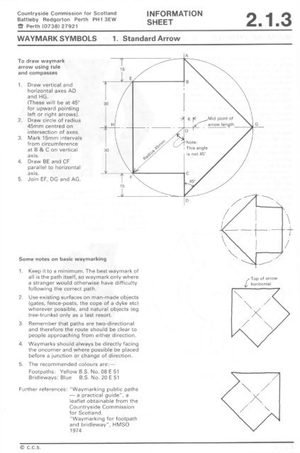
WAYMARK SYMBOLS 1. Standard Arrow<br />
To draw waymark<br />
arrow using rule<br />
and compasses<br />
1. Draw vertical and<br />
horizontal axes AD<br />
and HG.<br />
(These will be at 45°<br />
for upward pointing<br />
left or right arrows).<br />
2. Draw circle of radius<br />
45mm centred on<br />
intersection of axes.<br />
3. Mark 15mm intervals<br />
from circumference<br />
at B & C on vertical<br />
axis.<br />
4. Draw BE and CF<br />
parallel to horizontal<br />
axis.<br />
5. Join EF, DG and AG.<br />
Some notes on basic waymarking<br />
1. Keep it to a minimum. The best waymark of<br />
all is the path itself, so waymark only where<br />
a stranger would otherwise have difficulty<br />
following the correct path.<br />
2. Use existing surfaces on man-made objects<br />
(gates, fence-posts, the cope of a dyke etc)<br />
wherever possible, and natural objects (eg<br />
tree-trunks) only as a last resort.<br />
3. Remember that paths are two-directional<br />
and therefore the route should be clear to<br />
people approaching from either direction.<br />
4. Waymarks should always be directly facing<br />
the oncomer and where possible be placed<br />
before a junction or change of direction.<br />
5. The recommended colours are:—<br />
Footpaths: Yellow B.S. No. 08 E 51<br />
Bridleways: Blue B.S. No. 20 E 51<br />
Further references: "Waymarking public paths<br />
— a practical guide", a<br />
leaflet obtainable from the<br />
Countryside Commission<br />
for Scotland.<br />
"Waymarking for footpath<br />
and bridleway", HMSO<br />
1974<br />
© c.c.s.<br />
INFORMATION<br />
SHEET 2.1.3<br />
Top of arrow<br />
horizontal