

Download the 2012 Buyers Guide - Cactus Navigation ...
Download the 2012 Buyers Guide - Cactus Navigation ...
Download the 2012 Buyers Guide - Cactus Navigation ...

Create successful ePaper yourself
Turn your PDF publications into a flip-book with our unique Google optimized e-Paper software.
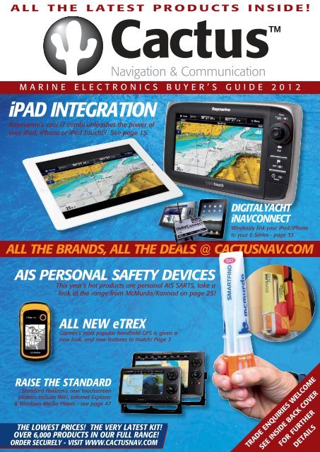
ALL THE LATEST PRODUCTS INSIDE!<br />
MARINE ELECTRONICS BUYER’S GUIDE <strong>2012</strong><br />
iPAD INTEGRATION<br />
Raymarine’s cool i7 combi unleashes <strong>the</strong> power of<br />
your iPad, iPhone or iPod Touch!!! See page 15<br />
ALL THE BRANDS, ALL THE DEALS @ CACT CAC CACTUSNAV.COM<br />
TUSNAV.COM<br />
AIS PERSONAL SAFETY DEVICES<br />
This year’s hot products are personal AIS SARTS, take a<br />
look at <strong>the</strong> range from McMurdo/Kannad on page 25! 5!<br />
ALL NEW eTREX<br />
Garmin’s most popular handheld GPS is given a<br />
new look, and new features to match! Page 3<br />
RAISE THE STANDARD<br />
Standard Horizon’s new touchscreen<br />
plotters include WiFi, Internet Explorer<br />
& Windows Media Player - see page 47<br />
THE LOWEST PRICES! THE VERY LATEST KIT!<br />
OVER 6,000 PRODUCTS IN OUR FULL RANGE!<br />
ORDER SECURELY - VISIT WWW.CACTUSNAV.COM<br />
DIGITALYACHT<br />
iNAVCONNECT<br />
Wirelessly link your iPad/iPhone<br />
to your E-Series - page 33<br />
TRADE ENQUIRIES WELCOME<br />
SEE INSIDE BACK COVER<br />
FOR FURTHER<br />
DETAILS
2<br />
CONTENTS<br />
Garmin 3<br />
Simrad 10<br />
B&G 10<br />
Lowrance 11<br />
NASA Marine 12<br />
Furuno 13<br />
Tacktick 14<br />
Raymarine 15<br />
Humminbird 20<br />
Geonav 21<br />
Echopilot 22<br />
McMurdo/Kannad 24<br />
Echomax 25<br />
Ocean Signal 26<br />
Navionics 27<br />
C-Map by Jeppesen 30<br />
DigitalYacht 32<br />
Digital Deep Sea 39<br />
KVH 40<br />
Intellian 41<br />
Icom 44<br />
Standard Horizon 46<br />
Shakespeare 48<br />
Sailor 49<br />
Thuraya 49<br />
Iridium 49<br />
Moerer 50<br />
Vesper 50<br />
Avtex 50<br />
Product Colour Code Key<br />
<strong>Navigation</strong> Equipment<br />
Autopilots<br />
Instruments<br />
Communications<br />
Echosounders/Fishfinders<br />
Electronic Cartography<br />
Welcome to <strong>Cactus</strong><br />
Introduction<br />
DEAR BOAT OWNER,<br />
Thanks for picking up our brochure and giving <strong>Cactus</strong> <strong>the</strong> chance to supply your next item of navigation and<br />
communication equipment. In an increasingly competitive market, we know that to stay on top we have to give<br />
our customers a great service and a unique offering.<br />
WHO WE ARE<br />
<strong>Cactus</strong> is a privately owned business operating with an office and warehouses in <strong>the</strong> UK and <strong>the</strong> US.<br />
I started <strong>the</strong> business after many years in <strong>the</strong> marine industry first as an electronics installation engineer and<br />
later as a sales and marketing manager for one of <strong>the</strong> manufacturers, working <strong>the</strong> UK and overseas. Before I<br />
started <strong>Cactus</strong>, marine electronics were ei<strong>the</strong>r sold from mail order chandlers who sold at low prices but lacked<br />
<strong>the</strong> specialist knowledge or <strong>the</strong> local technical dealers who had <strong>the</strong> knowledge but were on <strong>the</strong> whole<br />
expensive. My idea was to offer good technical expertise and low prices, hence our slogan and guiding<br />
principle<br />
WE GUARANTEE NOT TO BE BEATEN ON PRICE.<br />
The “<strong>Cactus</strong> price promise” guarantee you <strong>the</strong> best price, even in <strong>the</strong> event you have seen a price cheaper<br />
elsewhere. We try to keep our promise as simple as possible and not have lots of exceptions or caveats, so in<br />
a nut shell we will always match or better a price providing <strong>the</strong> product is from an official source, like for like<br />
and it’s not a discontinued product or promotion we can no longer source.<br />
WE ARE A REAL BUSINESS<br />
<strong>Cactus</strong> is a bricks and mortar business with premises and a warehouse full of stock. Next time you are looking<br />
at online retailers look carefully at <strong>the</strong>ir address (if <strong>the</strong>y put it on <strong>the</strong>ir site, many don’t) thanks to Google maps<br />
you can even take a look at <strong>the</strong>ir premises. You will see many of <strong>the</strong> retailers on <strong>the</strong> net are just one man<br />
bands working from home. But why does that matter? Well without premises <strong>the</strong>y can’t hold decent levels of<br />
stock, in fact most of <strong>the</strong>se companies don’t hold stock, and instead <strong>the</strong>y source from distributors who ship<br />
<strong>the</strong> goods for on <strong>the</strong>ir behalf. Many have no idea what <strong>the</strong>y are selling and most importantly have no<br />
infrastructure in place to deal with returning goods or service work.<br />
FREE INSTALLATION ADVICE<br />
Unlike many web retailers our sales team are marine engineers, so as well as being able to guide you through<br />
all <strong>the</strong> options <strong>the</strong>y can talk intelligently about all aspects of <strong>the</strong> installation. They can tell you <strong>the</strong> kit and tools<br />
you need, positioning antennas and display even how best to run cables. Our advice makes sure you get <strong>the</strong><br />
right kit and you get <strong>the</strong> most out of it. If you don’t want to install <strong>the</strong> equipment yourself we offer a comprehensive<br />
installation service.<br />
WE ARE THERE FOR YOU IF YOU GET A PROBLEM<br />
If you have a problem we don’t hide behind email address or restrict <strong>the</strong> times you can call us. If something<br />
you have bought from us isn’t working to your satisfaction, let us know and we will get it sorted.<br />
WE’VE BEEN IN THE BUSINESS A LONG TIME<br />
<strong>Cactus</strong> is now in its 2nd decade of trading, we know <strong>the</strong> solutions and products that work and ones that don’t.<br />
If you have an idea for a unique application or installation let us know, chances are we’ve already been <strong>the</strong>re<br />
and done it with ano<strong>the</strong>r customer. Over <strong>the</strong> years we have supplied equipment to tens of thousands of<br />
customers with boats ranging from day sailors to super yachts. Nearly all become repeat customers because<br />
<strong>the</strong>y like our pricing, customer service and business approach. We like to a build a rapport with our customers<br />
and get feedback on how <strong>the</strong>ir kit has performed; consequently we are able to give great advice. This advice<br />
doesn’t just save money, in one case recently it actually saved <strong>the</strong> life of a customer and his family in <strong>the</strong><br />
Sou<strong>the</strong>rn Ocean, (Check our website for more on this.)<br />
CACTUS IS A SOLID BUSINESS, OUR GROWTH & EXPANSION HAS BEEN CONSISTENT OVER THE YEARS<br />
In an industry where businesses come and go all <strong>the</strong> time, our strong credit rating and healthy balance sheet,<br />
make us one of <strong>the</strong> safest places to buy from. Remember your product warranty is always with <strong>the</strong> retailer, so<br />
if you get a problem you need to feel safe that <strong>the</strong> company you bought from is still in business.<br />
WE ARE AN AUTHORISED DEALER FOR ALL THE BRANDS<br />
<strong>Cactus</strong> is one of only a few internet retailers that is a dealer and service agent for ALL <strong>the</strong> major brands. We<br />
are not tied to a few suppliers which mean we can offer genuine unbiased advice. Unlike many online stores<br />
we are happy to talk you through a problem.<br />
I hope this gives you a brief explanation of why I believe you should buy from <strong>Cactus</strong>. I also hope what we<br />
offer in our catalogue and website is of interest. If you have any questions or queries I would be more than<br />
happy to answer <strong>the</strong>m directly through my email address at andrew@cactusnav.com.<br />
© <strong>2012</strong> <strong>Cactus</strong> <strong>Navigation</strong> & Communication Ltd. The information in this catalogue is correct at <strong>the</strong> time of going to press, using manufacturers’ specifications. However, products are constantly updated, hence <strong>Cactus</strong> can accept no responsibility for<br />
any errors in <strong>the</strong> description of any of <strong>the</strong> products featured in this catalogue.<br />
CALL NOW ON 020 78 33 34 35 • EMAIL SALES@CACTUSNAV.COM
Garmin<br />
Handheld <strong>Navigation</strong><br />
GARMIN eTREX 10<br />
Handheld GPS<br />
The eTrex 10 is a great choice for <strong>the</strong> budget conscious<br />
looking for a basic GPS device. It has a 2.2in sunlight<br />
readable monochrome display and comes with a<br />
worldwide basemap.<br />
KEY FEATURES<br />
• High-sensitivity, WAAS-enabled GPS receiver with<br />
HotFix® with GNSS support<br />
• Paperless geocaching<br />
• Waterproof standard: IEC 60529 IPX7<br />
• USB interface<br />
• Measures just 5.3 x 10.1 x 3.3cm, weighs 142g<br />
• Up to 25 hours of battery life, 2 x AA<br />
ALSO AVAILABLE<br />
NEW FOR<br />
• eTrex 20 - With 65k colour TFT display, 1.7Gb<br />
internal memory, microSD card slot<br />
<strong>2012</strong><br />
• eTrex 30 - All <strong>the</strong> features of <strong>the</strong> eTrex 20 with unit-to-unit<br />
wireless transfer, 3 axis electronic compass and barometric altimeter<br />
GARMIN GPS72H<br />
Handheld GPS<br />
This rugged GPS features a high sensitivity receiver for faster<br />
signal acquisition. WAAS enabled, waterproof and it floats!<br />
Also available as marine bundle pack with marine mounting<br />
bracket, 12v cigarette lighter cable and carrying case.<br />
KEY FEATURES<br />
• 500 waypoints, 50 routes<br />
• Alarms<br />
• Trip computer<br />
• Auto track log, 10 saved tracks<br />
• Course and speed filtering<br />
• Built-in celestial tables<br />
GARMIN DAKOTA 10 & 20<br />
2.6in Handheld Touchscreen Chartplotter<br />
Entry-level touchscreen handheld with high-sensitivity GPS with HotFix satellite<br />
prediction, and a worldwide basemap. Durable and waterproof, Dakota is built to<br />
withstand <strong>the</strong> elements and makes outdoor navigation simple<br />
with an easy to use interface. 850Mb internal memory.<br />
KEY FEATURES<br />
• 20hrs battery life (2 x AA)<br />
• Automatic turn by turn routing on roads<br />
• Optional mapping for detailed roads<br />
• 1000 waypoints, 50 routes, 10,000 track points<br />
• Chartsource and BlueChard g2 Vision compatible<br />
• Inbuilt hunting/fishing calendar, sun and moon info<br />
• Dakota 20 - microSD card slot, tilt compensated 3-axis<br />
compass, barometric altimeter, wireless data transfer, also<br />
accepts OS mapping<br />
GARMIN OREGON 450 & 550<br />
3in Handheld Touchscreen Chartplotter<br />
Rugged, lightweight and waterproof to IPX7, <strong>the</strong> Oregon<br />
range features a high sensitivity WAAS GPS, an easy to<br />
use interface and is ideal for both marine and land use<br />
with turn by turn routing on roads, a barometric altimeter<br />
and a tilt-compensated 3-axis electronic compass.<br />
KEY FEATURES<br />
• 16hrs battery life (2 x AA)<br />
• 850Mb memory<br />
• USB and NMEA0183 compatible<br />
• Wireless data transfer<br />
• Oregon450 - 1000 waypoints, 50 routes<br />
• Oregon550 - 2000 waypoints, 200 routes<br />
• 10,000 track points, 20 saved tracks<br />
• Internal basemap<br />
• Chartsource and BlueChard g2 Vision compatible<br />
• Supports geocaching GPX files<br />
• Inbuilt hunting/fishing calendar, sun and moon information and tide tables<br />
• Oregon450t & 550t - Preloaded with topographic charts<br />
• Oregon550/550t - 3.2 megapixel camera with autofocus, 4x digital zoom<br />
GARMIN Montana 600 Bundle<br />
Handheld GPS Chartplotter with G2 BlueChart UK & Ireland SD Card<br />
The New Montana marine bundle combines detailed mapping with a sturdy GPS<br />
handheld. The bundle includes G2 BlueChart UK & Ireland mapping (HXEU706L)<br />
featuring smooth layering and seamless integration of map graphics for easy panning,<br />
scrolling and zooming. With rich colours and shading for easy interpretation<br />
and clear visibility, it gives boaters greater capabilities on <strong>the</strong> water. The rugged<br />
Montana 600 features a bright 4in sunlight readable, 65k colour TFT touchscreen<br />
display, a High-sensitivity, WAAS-enabled<br />
GPS receiver and HotFix® and a<br />
Worldwide built-in basemap with<br />
shaded relief.<br />
KEY FEATURES<br />
• 3-axis compass<br />
• Barometric altimeter<br />
• Waterproof (IEC 60529 IPX7)<br />
• Multiple battery options (included)<br />
• microSD card slot for optional mapping<br />
• High speed USB and Serial interface<br />
• Wirelessly share data between compatible units<br />
GARMIN GPSMap62 & GPSMap62S<br />
Handheld GPS Chartplotter<br />
Rugged waterproof unit with a 2.6in sunlight-readable colour<br />
screen, 1.7Gb internal memory plus a built-in worldwide<br />
basemap with shaded relief. The GPSMap62S adds a<br />
microSD card slot for additional maps, barometric altimeter,<br />
electronic compass and unit-to-unit transfer functionality.<br />
KEY FEATURES<br />
• Add marine, topographic and road maps<br />
• High sensitivity, high precision GPS receiver<br />
• Photo navigation - download pictures from<br />
Garmin Connect Photos and navigate to <strong>the</strong>m<br />
• Compatible with Custom Maps - transform your own<br />
paper and electronic maps into downloadable maps<br />
• USB (high speed on 62S) and NMEA0183 interface<br />
• 20hr battery life, uses 2 x AA batteries<br />
• 2,000 waypoints, 200 routes, 10,000 track points,<br />
200 saved tracks<br />
GARMIN GPSMap78 & GPSMap78S<br />
Handheld GPS Chartplotter<br />
Rugged unit with crisp colour mapping, high-sensitivity<br />
receiver, moulded rubber side grips plus a microSD card<br />
slot for loading additional maps. The GPSMap78S adds<br />
an electronic compass, barometric altimeter, unit-to-unit<br />
transfer functionality and high speed USB interface.<br />
KEY FEATURES<br />
• Inbuilt worldwide basemap<br />
• Waterproof and floats<br />
• 1.7Gb internal memory<br />
• Add marine, topographic and road maps<br />
• BirdsEye satellite imagery (subscription required)<br />
• Compatible with Custom Maps - transform your own<br />
paper and electronic maps into downloadable maps<br />
• USB (high speed USB on 78S) and NMEA0183 interface<br />
• 20hr battery life, uses 2 x AA batteries<br />
GARMIN GPSMap620<br />
5.2in Colour Touchscreen Marine/Automotive Chartplotter<br />
Full-featured chartplotter featuring an automotive mode when loaded with City<br />
Navigator NT road charts. Preloaded with worldwide satellite basemap of shorelines<br />
and o<strong>the</strong>r surface features. Marine mode provides 3D “mariner’s eye view”<br />
above <strong>the</strong> waterline, “fish eye view” below <strong>the</strong> waterline and Auto Guidance<br />
that searches chart data to suggest <strong>the</strong> best passage.<br />
KEY FEATURES<br />
• Turn-by-turn voice prompts<br />
• 1500 waypoints, 50 routes (marine)<br />
• 1000 waypoints, 10 routes (automotive)<br />
• 10,000-point auto track log<br />
• AIS and DSC compatible<br />
• Optional remote antenna<br />
• Inbuilt tide and celestial tables<br />
• Optional flush mount kit<br />
Turn to <strong>the</strong> back page for pricing and ordering info NOW!<br />
3
4<br />
BLUECHART g2 & g2 VISION<br />
UK, Ireland, France Large<br />
BLUECHART g2 & g2 VISION<br />
Mediterranean Large<br />
BLUECHART g2 & g2 VISION<br />
Nordic Large<br />
BLUECHART g2 & g2 VISION<br />
Canada West Large<br />
BLUECHART g2 & g2 VISION<br />
Canada East Large<br />
BLUECHART g2 & g2 VISION<br />
USA West Coast Large<br />
BLUECHART g2 & g2 VISION<br />
USA East Coast Large<br />
BLUECHART g2 & g2 VISION<br />
USA Gulf of Mexico Large<br />
BLUECHART g2 & g2 VISION<br />
USA Alaska Large<br />
BLUECHART g2 & g2 VISION<br />
USA Great Lakes Large<br />
Garmin<br />
Electronic Cartography<br />
BLUECHART g2 & g2 VISION<br />
Caribbean Regular<br />
BLUECHART g2 & g2 VISION<br />
New Zealand Regular<br />
BLUECHART g2 & g2 VISION<br />
Asia East Regular<br />
Please note that this is just a small selection of<br />
<strong>the</strong> full Bluechart coverage - please call us for<br />
assistance if <strong>the</strong> cruising area you require is not<br />
shown here.<br />
We accept most major credit and debit cards
Garmin<br />
Cartography, Chartplotters & Chartsounders<br />
BLUECHART g2 & g2 VISION<br />
UK, Ireland, France Regular<br />
BLUECHART g2 & g2 VISION<br />
Europe South Atlantic Coast Regular<br />
BLUECHART g2 & g2 VISION<br />
Mediterranean Regular<br />
GARMIN GPSMap4x1/4x1S<br />
4in Colour Chartplotter/Fishfinder<br />
Available as a chartplotter (Map4x1) or a combination chartplotter/fishfinder<br />
(Map4x1S), this unit features an ultra-bright 4in colour QVGA display. The<br />
GPSMap4x1s comes with powerful dual frequency or dual beam sonar to clearly<br />
paint depth contours, fish targets, structure, etc. It’s also CANet capable, allowing<br />
sounder data to be shared with o<strong>the</strong>r plotter displays on your boat.<br />
KEY FEATURES<br />
• Satellite-enhanced 3D worldwide<br />
basemap<br />
• Preloaded US inland lakes maps<br />
• Preloaded US coastal maps<br />
• Preloaded with UK coastal maps<br />
• Models include dual frequency<br />
or dual beam sounder<br />
• Upgradeable to BlueChart g2<br />
Vision cartography via plug in card<br />
• Simple user interface, easy operation<br />
• Simplify navigation with Auto Guidance<br />
• NMEA2000 compatible<br />
GARMIN GPSMap5x1/5x1S<br />
5in Colour Chartplotter/Fishfinder<br />
Chartplotter (Map5x1) or combination<br />
chartplotter/fishfinder (Map5x1S) with<br />
all <strong>the</strong> features of <strong>the</strong> GPSMap4x1<br />
series, but with a larger ultra-bright 5in<br />
colour QVGA display.<br />
KEY FEATURES<br />
• GPSMap521 - Satellite-enhanced 3D<br />
worldwide basemap<br />
• GPSMap531 - Preloaded with US<br />
inland lakes maps<br />
• GPSMap541 - Also preloaded with<br />
US coastal maps<br />
• GPSMap551 - Also preloaded with<br />
UK coastal maps<br />
• S models include dual frequency or dual beam sounder<br />
ALL 4 & 5in MODELS SUPPLIED WITH<br />
Internal GPS antenna (optional external antenna), unit cover, tilt/swivel<br />
mount, cables, transducers sold separately<br />
GARMIN GPSMap750/750S<br />
7in Colour Touchscreen Chartplotter/Fishfinder<br />
The GPSMAP 750 series can connect with any Garmin GMR series marine radar<br />
and come preloaded with UK & Ireland charts, which can easily be added to with<br />
optional BlueChart® g2 or g2 Vision® cards for expanded coverage of specific<br />
regions. The 750s features a powerful 1000 watt capable digital sounder.<br />
KEY FEATURES<br />
• NMEA 2000 connectivity for engine, fuel, VHF, autopilot and o<strong>the</strong>r data monitoring<br />
• Single SD memory card slot<br />
• Two NMEA 0183 ports<br />
GPSMap750S FEATURES<br />
• Optional 1kW transducer: 1000W (RMS) 8000W (p to p)<br />
• Optional 500W dual frequency transducer: 500W (RMS) 4000W (p to p)<br />
• Depth: 2,000ft / 600m (1kW), 1,500ft / (500W)<br />
• UltraScroll high rep rate sonar provides lightning-fast screen updates<br />
SUPPLIED WITH<br />
Internal GPS antenna (optional external antenna), bail mount with built-in cable<br />
management, flush mount gasket, power/data cable, protective cover<br />
Turn to <strong>the</strong> back page for pricing and ordering info NOW!<br />
5
6<br />
GARMIN GPSMap4000 SERIES<br />
8.4in, 10.4in & 12.1in Colour Combination Displays<br />
These powerful combi displays combine video-quality<br />
resolution and luminous colour with <strong>the</strong> latest sensor<br />
and data options. Worldwide satellite imagery<br />
enhances <strong>the</strong> standard vector basemap format, add<br />
<strong>the</strong> optional BlueChart Vision card for high-resolution<br />
aerial reference photos which help in navigating tricky<br />
harbours and channels or locating places such as<br />
marinas, fuel barges or restaurants. The g2 Vision<br />
plugin data card also allows <strong>the</strong> units to graphically<br />
depict a true 3D “mariner’s eye” topside view or “fish<br />
eye” underwater navigation perspective.<br />
KEY FEATURES<br />
• GPSMap4008/4208 - 8.4in 640x480 pixel VGA<br />
• GPSMap4010/4210 - 10.4in 800x600 pixel SVGA<br />
• GPSMap4012/4212 - 12.1in 1024x768 pixel XGA<br />
• Worldwide satellite basemap<br />
• GPSMap4208, 4210 & 4212 - preloaded with US<br />
coastal maps<br />
• Auto Guidance searches all <strong>the</strong> chart features to<br />
suggest <strong>the</strong> best known charted route for navigation<br />
• Dual Bluechart g2 card slots<br />
• 4000 waypoints, 50 outes, 300 waypoints/route<br />
• GPSMap4012/4212 - 2 video inputs for onboard<br />
cameras, 1 SVGA PC monitor output<br />
• Anchor drag, arrival, off-course, shallow water, deep<br />
water, proximity waypoint, clock and battery alarms<br />
• Inbuilt celestial tables for sun and moon calculations<br />
• Add radar with optional GMR series digital antennas<br />
• Radar/chart overlay and split screen modes<br />
• MARPA target tracking<br />
• Add sonar with optional GSD22 digital remote<br />
sounder<br />
HOT<br />
PRODUCT<br />
SUPPLIED WITH<br />
GPS 17 WAAS sensor, A/V cable, power/data cable, mounting bracket, unit cover, flush mount, bail mount<br />
GARMIN GPSMap5000 SERIES<br />
8.4in, 12.1in & 15in Touchscreen Colour Combination Displays<br />
The GPSMap 5000 series features a radical touchscreen<br />
interface that makes navigation as easy as<br />
pointing your finger. The units are supplied with a<br />
worldwide basemap with high-quality satellite images<br />
in place of more traditional charts. For even more<br />
detail, you can add charts easily using <strong>the</strong> SD card<br />
slots. Keep watch on your engine room or o<strong>the</strong>r<br />
areas of your vessel by connecting a live video feed<br />
using <strong>the</strong> video input/output.<br />
BlueChart g2 Vision charts add a whole new dimension<br />
of exceptional feature - 3D mariner’s eye view or<br />
fish eye view provides you with a 3D perspective of<br />
map information, both above and below <strong>the</strong> waterline.<br />
High-resolution satellite images and aerial photographs<br />
help you orient yourself in unfamiliar areas.<br />
Auto Guidance creates a route that avoids shallow<br />
water, buoys and o<strong>the</strong>r obstacles.<br />
KEY FEATURES<br />
• All <strong>the</strong> features of <strong>the</strong> 4000 series combi displays<br />
• Innovative touch-screen design<br />
• Dual Bluechart g2 card slots<br />
• Add radar with optional GMR series digital antennas<br />
• Add sonar with optional GSD22 digital remote<br />
sounder<br />
• GPSMap5008/5208 - 8.4in 640x480 pixel VGA<br />
• GPSMap5012/5212 - 12.1in 1024x768 pixel XGA<br />
• GPSMap5015/5215 - 15in 1024x768 pixel XGA<br />
• GPSMap5208, 5212 & 5215 - preloaded with US<br />
coastal maps<br />
EDITOR’S<br />
CHOICE<br />
SUPPLIED WITH<br />
GPS 17 WAAS sensor, A/V cable, power cable, mounting bracket, unit cover, flush mount, marine grommet kit,<br />
NMEA2000 drop cable, NMEA2000 T-connector & terminator kit, NMEA2000 power cable, NMEA0183 cable<br />
We accept most major credit and debit cards<br />
Garmin<br />
Combi Displays<br />
GARMIN HD DIGITAL RADAR<br />
High Definition Digital Radar<br />
The Garmin HD digital radomes and open array<br />
antennas offer high-powered Digital Signal Processing<br />
for sharper radar imagery and improved target separation.<br />
Automatic pulse optimisation matches pulse<br />
width and repetition rate with <strong>the</strong> selected range.<br />
Self-contained signal<br />
processing provides a more precise, easy to read<br />
signature. Data is transmitted over <strong>the</strong> Garmin<br />
Marine Network to any compatible Garmin display.<br />
KEY FEATURES<br />
• Narrow beamwidth<br />
• MARPA target tracking (10 targets)<br />
• 24/30rpm dual rotation on open array antennas<br />
• Minimum range - 20m<br />
Tech info<br />
Garmin Radar Scanners<br />
When ordering your radar system you’ll<br />
need to specify <strong>the</strong> antenna you require -<br />
Part No. Size Power Beam Type Range<br />
GMR 18 18in 4kW RD 36nm<br />
GMR 18HD 18in 4kW 5º RD 36nm<br />
GMR 24HD 24in 4kW 3.6º RD 48nm<br />
GMR 404xHD 48in 4kW 1.8º OA 72nm<br />
GMR 406xHD 72in 4kW 1.18º OA 72nm<br />
GMR 604xHD 48in 6kW 1.8º OA 72nm<br />
GMR 606xHD 72in 6kW 1.1º OA 72nm<br />
GMR 1204xHD 48in 12kW 1.8º OA 72nm<br />
GMR 1206xHD 72in 12kW 1.1º OA 72nm<br />
RD - Radome Antenna (enclosed)<br />
OA - Open Array<br />
HD - High Definition<br />
GARMIN GC10<br />
Marine Camera<br />
Durable and waterproof, <strong>the</strong> Garmin GC 10 was built<br />
to brave <strong>the</strong> elements. With a<br />
small and unobtrusive design<br />
in a rugged housing that makes<br />
it easy to mount almost<br />
anywhere on your boat.<br />
KEY FEATURES<br />
• Can be used with on-board TV,<br />
video monitors or chartplotters with video input<br />
• No need to add separate hardware to view feed<br />
• Standard-image and reverse-image models<br />
• Automatic infra-red functionality<br />
GARMIN GFS10<br />
Fuel Sensor<br />
Add fuel tracking to your Garmin<br />
combi and optimise your<br />
fuel economy.<br />
KEY FEATURES<br />
• 10-22v<br />
• Unlike o<strong>the</strong>r fuel sensors<br />
it will measure fuel level when connected to an<br />
existing analogue fuel gauge or resistive fuel tank<br />
sensor<br />
• Flow rate 2 - 50 Gallons per hour per engine<br />
• Data transfer via CANet or NMEA 2000
Garmin<br />
Touchscreen Combi Displays<br />
GARMIN GPSMap6000 SERIES<br />
8.4 & 12.1in Colour Combination Displays<br />
The next evolution in Garmin’s series of full-featured marine products, <strong>the</strong> 6000<br />
series brings unprecedented speed to your vessel with Garmin G Motion technology<br />
- blazing-fast map redraw and refresh rates offers near real-time data to guide<br />
you. Whe<strong>the</strong>r you’re in a crowded harbour or in uncertain wea<strong>the</strong>r, you’ll have <strong>the</strong><br />
confidence to navigate with <strong>the</strong> 6000 series as your guide. Compatible with an<br />
optional remote for added flexibility and with a sleek and stylish design that was<br />
built to brave <strong>the</strong> elements, <strong>the</strong>y look great in any position on <strong>the</strong> boat.<br />
The 6000 series features a worldwide basemap with high quality satellite images<br />
in place of more traditional charts, plus you can easily add charts with <strong>the</strong> dual<br />
card slots. Optional BlueChart g2 Vision charts add a whole new dimension of<br />
exceptional features to your chartplotter - MarinerEye view and FishEye view provide<br />
you a 3-dimensional perspective of map information, both above and below<br />
<strong>the</strong> waterline. High-resolution satellite images and aerial photographs help you<br />
orient yourself in unfamiliar areas. Auto Guidance technology searches through all<br />
relevant charts to create a route you can actually follow - one that avoids obstacles,<br />
shallow water, buoys and o<strong>the</strong>r obstructions.<br />
Keep tabs on your engine room or o<strong>the</strong>r area of your boat with a live video feed<br />
using <strong>the</strong> video input and output options. The 6000 series easily connects to<br />
your network so you can interface with additional displays and add remote sensors,<br />
cameras and more. Once connected, you can share information between<br />
<strong>the</strong> 6000 series and o<strong>the</strong>r chartplotters on your boat. You can also add highpowered<br />
radar, sonar and XM satellite wea<strong>the</strong>r and radio to your system.<br />
KEY FEATURES<br />
• GPSMap6008/6208 - 12.1in 1024x768 pixel XGA<br />
• GPSMap6012/6212 - 15in 1024x768 pixel XGA<br />
• Worldwide satellite basemap<br />
• GPSMap6208 & 6212 preloaded with US coastal maps<br />
• Add radar with optional GMR series digital antennas<br />
• Radar/chart overlay and split screen modes<br />
• MARPA target tracking<br />
• Add sonar with optional GSD22 digital remote sounder<br />
• 5000 waypoints, 100 routes, 50,000 track points, 50 saved tracks<br />
• 4 NMEA 0183 inputs, 2 NMEA 0183 outputs, 2 video inputs for onboard<br />
cameras, 1 PC monitor video output<br />
GARMIN GPSMap7000 SERIES<br />
12.1 and 15.5in Touchscreen Colour Combination Display<br />
Put <strong>the</strong> power of Garmin’s next-generation marine navigator right at your fingertips with <strong>the</strong> GPSMap7000 Series.<br />
The 7000 series brings all <strong>the</strong> features, all <strong>the</strong> power and speed of <strong>the</strong> 6000 series but with innovative touchscreen<br />
control and <strong>the</strong> choice of larger displays. The 7000 Series comes standard with a worldwide, satellite-enhanced<br />
basemap as well as video-quality resolution on an impressive 12.1in or 15.5in XGA display. The 7000 Series also<br />
provides total system integration – allowing support for <strong>the</strong> addition of sonar, radar, wea<strong>the</strong>r and more. For additional<br />
enhanced features, you can add <strong>the</strong> optional BlueChart g2 Vision card.<br />
KEY FEATURES<br />
• GPSMap7012/7212 - 12.1in 1024x768 pixel XGA<br />
• GPSMap7015/7215 - 15in 1024x768 pixel XGA<br />
• Dual Bluechart g2 card slots<br />
• Worldwide satellite basemap<br />
• GPSMap7212 & 7215 preloaded with US coastal maps<br />
• Auto Guidance searches all <strong>the</strong> chart features to suggest <strong>the</strong> best known charted<br />
route for navigation<br />
• AIS compatible<br />
• Add radar with optional GMR series digital antennas<br />
• Radar/chart overlay and split screen modes plus MARPA target tracking<br />
• Add sonar with optional GSD22 digital remote sounder<br />
• 5000 waypoints, 100 routes, 50,000 track points, 50 saved tracks<br />
• 4 NMEA 0183 inputs, 2 NMEA 0183 outputs<br />
• GPSMap7012/7212 - 2 video inputs for onboard cameras,<br />
1 PC monitor video output<br />
• GPSMap7015/7215 - 4 video inputs for onboard cameras,<br />
1 PC monitor video output, 1 PC monitor video input<br />
• Anchor drag, arrival, off-course, shallow water, deep water, proximity waypoint,<br />
clock and battery alarms<br />
• Inbuilt tide tables and celestial tables for sun and moon calculations<br />
HOT<br />
PRODUCT<br />
• Anchor drag, arrival, off-course, shallow water, deep water, proximity waypoint,<br />
clock and battery alarms<br />
• Inbuilt celestial tables for sun and moon calculations<br />
• Tide tables<br />
• AIS compatible<br />
SUPPLIED WITH<br />
GPS 17x NMEA 2000 with pole, flush and under deck mount adapters, front<br />
cover, power cable, video cable, NMEA 0183 cable, NMEA 2000 drop cable, 10m<br />
NMEA 2000 backbone cable, NMEA 2000 power cable, NMEA 2000 T-connector<br />
and terminator kit, bail mount, flush mount kit, marine grommet kit<br />
SUPPLIED WITH<br />
GPS 17x NMEA 2000 with pole, flush and under deck mount adapters, front cover, power cable, video cable, NMEA 0183 cable, NMEA 2000 drop cable, 10m NMEA<br />
2000 backbone cable, NMEA 2000 power cable, NMEA 2000 T-connector and terminator kit, bail mount, flush mount kit, marine grommet kit<br />
Turn to <strong>the</strong> back page for pricing and ordering info NOW!<br />
7
8<br />
GARMIN echo 100<br />
4in Mono Single Beam Fishfinder<br />
State-of-<strong>the</strong>-art target tracking technology brings a<br />
new level of fishfinding capability to <strong>the</strong> budget<br />
minded buyer. Garmin’s<br />
exclusive HD-ID target<br />
tracking technology brings<br />
enhanced separation and<br />
definition of images on <strong>the</strong><br />
echo 100’s fast refreshing<br />
4in grayscale display.<br />
The single-beam 200kHz<br />
transducer lets you scan to<br />
depths of up to 180m.<br />
KEY FEATURES<br />
• Garmin HD-ID technology<br />
• 200kHz, 100 watts (RMS)<br />
• Beam width to 60º<br />
• Max Depth 180m (600ft)<br />
• Compact design for smaller boats<br />
SUPPLIED WITH<br />
Tilt/swivel mount, transducer, trolling motor clamp<br />
and transom mount<br />
GARMIN echo 150<br />
4in Mono Dual Beam Fishfinder<br />
With dual-beam technology at a single-beam price,<br />
echo 150 is <strong>the</strong> sport fisherman’s dream. Scan to<br />
depths of 400m in fresh water.<br />
In shallower water, a viewing<br />
angle of up to 120º lets you<br />
see fish well beyond <strong>the</strong> sides<br />
of your boat. HD-ID target<br />
tracking technology provides<br />
you with better separation and<br />
definition of images.<br />
KEY FEATURES<br />
• Garmin HD-ID technology<br />
• 200/77kHz, 200 watts (RMS)<br />
• Beam width to 120º<br />
• Max Depth 400m (1,300ft)<br />
• Compact design<br />
SUPPLIED WITH<br />
Tilt/swivel mount, transducer,<br />
trolling motor clamp and transom mount<br />
GARMIN GMI 10<br />
Digital Marine Instrument Display<br />
Radical colour multifunction display that integrates<br />
with <strong>the</strong> Garmin Marine Network and o<strong>the</strong>r sensors<br />
via NMEA2000 and NMEA0183. By showing data<br />
from multiple remote sensors on one display, <strong>the</strong><br />
GMI 10 offers a streamlined approach to marine<br />
instrumentation. Display data such as depth, speed,<br />
water and air temperature, wind speed/direction, fuel<br />
flow rate, engine data, fuel level and more, depending<br />
upon what sensors are connected. The GMI 10 supports<br />
more than two dozen standard NMEA2000 and<br />
more than 20 NMEA0183 data sentences and can<br />
also connect to any Garmin Marine Network chartplotters<br />
with an NMEA 2000 port.<br />
KEY FEATURES<br />
• Clear, bright 320 x 240 pixel colour QVGA display<br />
• Flexible, expandable system suits all boat sizes<br />
• GWS 10 wind sensor with barometric pressure and<br />
air temperature<br />
• GPS 17x 12-channel WAAS GPS sensor<br />
• GFS 10 fuel sensor<br />
• NMEA2000 and NMEA0183 compatible<br />
• Waterproof<br />
• Flush mountable<br />
GARMIN echo 200<br />
5in Mono Dual Beam Fishfinder<br />
Combines <strong>the</strong> features of <strong>the</strong> echo 150 with a larger<br />
5in grayscale display. The dual-beam transducer<br />
scans deep water to 450m with a wide scanning<br />
angle perfect for shallow water<br />
as well. Smooth Scaling<br />
technology means you<br />
won’t lose sight of <strong>the</strong><br />
sonar history as <strong>the</strong> unit<br />
changes depth ranges<br />
and allows you to rewind<br />
your sonar history in order<br />
to ensure that you haven’t<br />
missed a thing.<br />
KEY FEATURES<br />
• Garmin HD-ID technology<br />
• 200/77kHz, 200 watts (RMS)<br />
• Max depth 450m (1,500 ft)<br />
• Beam width to 120º<br />
SUPPLIED WITH<br />
Tilt/swivel mount, transducer, trolling motor clamp<br />
and transom mount<br />
GARMIN echo 500c/550c<br />
5in Colour Dual Beam Fishfinders<br />
Range of colour dual frequency fishfinders ideal for both shallow<br />
and deep water. HD-ID target tracking technology brings<br />
enhanced separation and definition of images. Smooth<br />
Scaling technology means you won’t lose sight of <strong>the</strong> sonar<br />
history as <strong>the</strong> unit changes depth ranges and allows you to<br />
rewind your sonar history in order to ensure that you haven’t<br />
missed a thing. The echo 550c boasts a video-quality<br />
640x480-pixel VGA screen, providing an amazing level of<br />
detail on fish returns, structure and bottom contours.<br />
KEY FEATURES<br />
• Garmin HD-ID technology<br />
• 200/77kHz, 500 watts (RMS)<br />
• Max depth 580m (1,900 ft)<br />
• Beam width to 120º<br />
• echo 500c - 5in colour QVGA 234 x 320 pixel display<br />
• echo 550c - 5in colour VGA 480 x 640 pixel display<br />
Garmin<br />
Fishfinders & Instruments<br />
GARMIN echo 300c<br />
3.5in Colour Dual Beam Fishfinder<br />
The echo 300c combines <strong>the</strong> performance and features<br />
of <strong>the</strong> echo 200 with <strong>the</strong> compact design of<br />
<strong>the</strong> echo 150 and a 3.5in<br />
colour sunlight viewable<br />
display. echo 300c is <strong>the</strong><br />
only colour dual-beam<br />
fishfinder on <strong>the</strong> market<br />
at this price, making it <strong>the</strong><br />
premier sonar option for<br />
fishermen on a budget!<br />
KEY FEATURES<br />
• Garmin HD-ID technology<br />
• 200/77kHz, 200 watts (RMS)<br />
• Max depth 450m (1,500 ft)<br />
• Beam width to 120º<br />
SUPPLIED WITH<br />
Tilt/swivel mount, transducer, trolling motor clamp<br />
and transom mount<br />
SUPPLIED WITH<br />
80/200kHz transom transducer, power/data cable, mounting bracket, flush mount hardware<br />
SUPPLIED WITH<br />
Display, mounting hardware, sun cover, power/NMEA 0183 cable, NMEA 2000 power cable, NMEA 2000 drop<br />
cable, NMEA 2000 tee & terminator kit<br />
GWS 10 Wind Sensor<br />
GPS 17x GPS Sensor<br />
We accept most major credit and debit cards<br />
HOT<br />
PRODUCT<br />
GFS 10 Fuel Sensor
Autopilot, AIS & VHF Radios<br />
GARMIN GHP 12<br />
Sailboat Autopilot System<br />
GHP 12 brings Garmin’s marine autopilot technology<br />
to sailboats. This second-generation autopilot<br />
is designed to suit most 20 to 70ft sailboats with<br />
linear-actuated steering systems with a choice of two<br />
drives (supplied separately).<br />
KEY FEATURES<br />
• Steer to GPS (requires GPS input)<br />
• Integrates with GWS 10 wind sensor<br />
or compatible NMEA windvanes<br />
• Heading hold, wind hold, step turn, tack/gybe<br />
LINEAR ACTUATORS AVAILABLE<br />
• Class A Drive Unit - up to 28,500lbs displacement<br />
• Class B Drive Unit - up to 79,000lbs displacement<br />
SUPPLIED WITH<br />
GHC 10, course computer, electronic control unit,<br />
interconnect cable, buzzer, power cable, NMEA2000<br />
drop cable, 2 x NMEA2000 T-connectors. Drive units<br />
sold separately<br />
GARMIN GHP 10<br />
Powerboat Autopilot System<br />
Powerful, easy to use autopilot system. The GHC<br />
10 fixed control unit integrates via a NMEA2000 bus,<br />
so autopilot heading data can easily be shared with<br />
o<strong>the</strong>r devices including chartplotters. Up to three<br />
GHC 10 controls can be interfaced with a single pilot,<br />
ideal for multiple helm station boats.<br />
KEY FEATURES<br />
• Suitable for all types of hydraulically steered power<br />
boats - inboard, outboard, stern-drive, diesels<br />
• NEW FOR 2011 - GHP 10V version for Volvo Penta<br />
IPS steering systems<br />
• No rudder feedback unit required<br />
• Gyro-stabilised compass<br />
• Patented Shadow Drive technology automatically<br />
disengages autopilot if <strong>the</strong> helm is turned and<br />
re-engages when a steady course is held<br />
• Hold position against wind, waves or current<br />
• Can steer in reverse<br />
• Bright 320 x 240 pixel QVGA colour LCD display<br />
HYDRAULIC REVERSING PUMPS AVAILABLE<br />
• 1.2L (up to 160cc, 10in 3 )<br />
• 2.0L (160-400cc, 10-24in 3 )<br />
• 2.1L (160-400cc, 10-24in 3 ), engine size 400hp+<br />
SUPPLIED WITH<br />
GHC 10, course computer, gyro compass, drive unit,<br />
interconnect cable, buzzer, power cable, NMEA2000<br />
drop cable, NMEA2000 T-connector<br />
GARMIN VHF 100i & VHF 200i<br />
Fixed DSC VHF Radios<br />
The Garmin VHF 100i and 200i range of VHF radios feature a large backlit 3.2in display, rotary volume, squelch<br />
and channel selection knobs, up to 25W transmission power and provides full Class D DSC capability.<br />
KEY FEATURES<br />
• Locate and monitor up to three o<strong>the</strong>r boats with position tracking capability<br />
• 200i - Two-way hailer functionality when connected to compatible horn speaker<br />
• 200i - Automatic and manual foghorn signals and adjustable base fog frequencies<br />
• LOCAL receiver mode improves performance in busy port environments<br />
• Ergonomic fist mic with built-in speaker<br />
• Programmable international channels<br />
• ATIS and private channel customisation options<br />
• 200i - Multi-language user interface<br />
• 200i - Supports GHS 10i second station<br />
• Automatic power-on when boat starts<br />
• Waterproof to IPX7 standard<br />
• Easy front flush-mounting option<br />
• NMEA 0183 compatible<br />
• 200i - NMEA 2000 compatible<br />
SUPPLIED WITH<br />
Fistmike, power cable, hailer/NMEA cable (200i), mounting bracket, flush mount gasket, protective cover<br />
GARMIN VHF 300i & VHF 300i AIS<br />
Fixed DSC VHF Radios<br />
Multi-station Class D DSC VHF transceiver comes with a two-way hailer system and a voicemail feature<br />
that lets you pre-record a 15-second message and send to any DSC radio. Replay <strong>the</strong> last 90<br />
seconds of any incoming voice transmission at <strong>the</strong> touch of a button. Listen via <strong>the</strong> supplied 4in<br />
active speaker with volume control, <strong>the</strong> handset’s inbuilt speaker or third-party passive speakers.<br />
Also features an inbuilt dual channel AIS receiver which<br />
simultaneously receives Class A and Class B AIS signals.<br />
NMEA 0183 and 2000 compatible.<br />
GARMIN AIS300<br />
Black Box AIS Receiver<br />
This affordable NMEA2000 compatible black box AIS<br />
receiver alerts you to potential collisions with o<strong>the</strong>r<br />
AIS-equipped vessels in your vicinity. It integrates<br />
with a Garmin chartplotter and VHF radio to enable<br />
automatic AIS target calling and to display AIS target<br />
data directly on <strong>the</strong> chartplotter screen.<br />
KEY FEATURES<br />
• Class A and Class B reception<br />
• Closest Point of Approach (CPA) alarm<br />
• 12-volt and 24-volt boat systems<br />
• NMEA 0183 output with selectable speed<br />
• Inbuilt passive splitter enables one VHF antenna to<br />
serve both <strong>the</strong> AIS 300 and any VHF radio<br />
SUPPLIED WITH<br />
Power/data cable, 2m NMEA2000 cable, NMEA2000<br />
T-connector, VHF interconnect cable, mounting kit<br />
KEY FEATURES<br />
• Space-saving black box configuration<br />
• 30w hailer when connected to compatible horn speaker<br />
• GHS 10i handset microphone with 2in LCD display<br />
• Rotary key and three soft buttons for dynamic controls<br />
• Multi station support with intercom facility<br />
• Locate and monitor up to three o<strong>the</strong>r boats with position<br />
tracking capability<br />
• VHF 300i AIS - display AIS ship information - position,<br />
course and speed of AIS equipped vessels within range<br />
• Waterproof to IPX7 standard<br />
SUPPLIED WITH<br />
GHS 10i handset microphone, active speaker, power<br />
cable, 10m deck cable, mounting hardware<br />
GARMIN AIS600<br />
Black Box AIS Transceiver<br />
Receive and transmit AIS data. Inbuilt active splitter<br />
allows one VHF antenna to serve both <strong>the</strong> AIS 600<br />
and VHF radio with minimal signal loss. The AIS 600<br />
connects to your existing Garmin marine network and<br />
is controlled via <strong>the</strong> chartplotter, so all <strong>the</strong> information<br />
you need will be right at your fingertips.<br />
Turn to <strong>the</strong> back page for pricing and ordering info NOW!<br />
9<br />
HOT<br />
PRODUCT<br />
KEY FEATURES<br />
• ClearTrack technology ensures no interruption of<br />
AIS traffic position while <strong>the</strong> VHF radio is in use<br />
• Integrates with chartplotters & VHF via NMEA2000<br />
• Call With Radio function - initiate a call to any MMSI<br />
target directly from <strong>the</strong> chartplotter<br />
SUPPLIED WITH<br />
GPS antenna, pole & surface mount, power cable,<br />
SRM cable, 2m NMEA2000 cable, NMEA2000<br />
T-connector, USB cable, 2m VHF interconnect cable,<br />
PC/Software CD, mounting kit
10<br />
SIMRAD NSS<br />
7, 8 & 12in Touchscreen Displays<br />
NEW FOR<br />
<strong>2012</strong><br />
KEY FEATURES<br />
• Touch screen user interface<br />
• Complementary rotary and button control<br />
• Network up to four processors via E<strong>the</strong>rnet and<br />
SimNet / NMEA2000<br />
• Network with Simrad NSE and NSO systems<br />
• Internal GPS with external option<br />
• Autopilot Integration<br />
• BEP C Zone integration<br />
• Audio Support<br />
SIMRAD HD RADARS<br />
High Definition Digital Radar<br />
KEY FEATURES<br />
• DX42S 2kW 18in Radome, 24nm, 5.3º beamwidth<br />
• DX64S 4kW 24in Radome, 48nm, 4º beamwidth<br />
• TX06S 6kW 4ft Open Array, 64nm, 1.8º beamwidth<br />
• TX10S 10kW 6ft Open Array, 72nm, 1.2º beamwidth<br />
• TX25S 25kW 8ft Open Array, 96nm, 1º beamwidth<br />
SIMRAD BROADBAND RADAR 3G/4G<br />
Networked Radar<br />
KEY FEATURES - 3G & 4G<br />
• Crystal clear image<br />
• Automatic clarity<br />
• 10 MARPA tracking<br />
• Dual guard zones<br />
• Instant on<br />
• Low power consumption<br />
• Extremely low emissions<br />
KEY FEATURES - 4G ONLY<br />
• 50% greater ranger than 3G<br />
• Dual range (when used with NSE, Zeus and NSO)<br />
• 48 RPM option<br />
• Advanced target detection<br />
SIMRAD TP10, TP22 & TP32<br />
Cockpit Tillerpilots<br />
NEW FOR<br />
<strong>2012</strong><br />
KEY FEATURES<br />
• TP10 (Up to 10m) - Budget standalone Tillerpilot.<br />
• TP22 (Up to 11m) - Faster hard over time plus<br />
SimNet and NMEA compatibility.<br />
• TP32 (Up to 12m) - Top spec high performance<br />
pilot with 85kg thrust and ultra-fast hard over time.<br />
• Waterproof double sealed design<br />
• NMEA interfacing to GPS & windvane (TP22/32)<br />
• SimNet compatible (TP22/32)<br />
• Optional external fluxgate sensor (TP22/32)<br />
• Hand remote option (TP22/32)<br />
SUPPLIED WITH<br />
Mounting kit, deck socket (TP22/32 only)<br />
SIMRAD NSE8 & NSE12<br />
8in & 12in Combi Displays<br />
KEY FEATURES<br />
• Single, Dual or multi-station configurations<br />
• Intuitive control interface for easy operation<br />
• Input and output of video or navigation data<br />
• Network NMEA0183, NMEA2000 or Simnet data<br />
• Pre-loaded with complete European Navionics<br />
Platinum charts for Europe<br />
• Award winning echosounder and radar technology<br />
• Brilliant Low Power LED Display Technology<br />
SIMRAD SONICHUB<br />
Marine Audio Server<br />
KEY FEATURES<br />
• Four channel x 50 watt speaker amplifier<br />
• AM/FM stereo tuner<br />
• Line-out to subwoofer<br />
• Audio source inputs including Apple products,<br />
o<strong>the</strong>r MP3 sources via USB port and flash drive<br />
• Stereo AUX line input for audio, mono line input for<br />
intercom, alarm and emergency override<br />
• Music control for up to three individual zones<br />
B&G ZEUS Z8 & Z12<br />
8in & 12in Combi Displays<br />
HOT<br />
PRODUCT<br />
KEY FEATURES<br />
• Radar, sail navigation and wea<strong>the</strong>r chart overlays<br />
• Water and ground vectors show <strong>the</strong> effect of tide<br />
and leeway on your course<br />
• Mark and boat laylines, with time and distance to<br />
layline for each tack<br />
• WindPlot allows you to make route choice decisions<br />
- whe<strong>the</strong>r to tack or stand on in <strong>the</strong> next gust etc<br />
• B&G H-Link, NMEA0183 & NMEA2000 compatible<br />
• Edit and backup of H3000 Polar tables<br />
• Preloaded cartography (Nautic Insight for <strong>the</strong> USA,<br />
Navionics coastal packages for Europe and APAC)<br />
• Optional cartography including Navionics Platinum+<br />
• Compatible with wide range of Navico equipment<br />
including Broadband Radar, SonicHub and o<strong>the</strong>r<br />
approved E<strong>the</strong>rnet, SimNet and NMEA2000 devices<br />
Simrad, B&G<br />
<strong>Navigation</strong> Equipment<br />
SIMRAD RS25 + AHK05<br />
Fixed DSC VHF and Wireless Handset<br />
KEY FEATURES<br />
• Intercom and Conference Features<br />
• Position display if integrated with GPS<br />
• Position Polling, Track your Buddy and Group Call<br />
• Barometer, <strong>the</strong>rmometer and wea<strong>the</strong>r forecasting<br />
• Dual watch, Tri watch and All-Scan functions<br />
• ATIS facility for inland waterways<br />
• Waterproof to JIS-7<br />
• NMEA 0183 input<br />
SIMRAD NAIS300 & AI50<br />
AIS Class B Transceiver Units<br />
KEY FEATURES<br />
• Plug and Play installation via a NMEA0183 NNMEA0183<br />
or Simnet<br />
• Both models can be integrated with a compatible<br />
chart display or PC via NMEA0183 or Simnet<br />
SIMRAD BSM-1<br />
Broadband Sounder Module<br />
KEY FEATURES<br />
• Tri-frequency capability for optimal performance<br />
• Deep water performance of over 3000ft<br />
• Low Power and Low-noise Sonar<br />
• High Resolution Linear receiver providing superior<br />
clarity in shallow and mid water<br />
B&G TRITON<br />
Instrument System<br />
KEY FEATURES<br />
NEW FOR<br />
• Multifunction “do it all” display <strong>2012</strong><br />
• Straightforward user interface<br />
• Large 4.1in colour display -<br />
nearly 40% more area than competing products<br />
• Bonded screens - excellent visibility in all conditions<br />
• Low power consumption<br />
• Dedicated pilot control - or interface with Zeus MFD<br />
• B&G Wind sensor technology<br />
We accept most major credit and debit cards
Lowrance<br />
<strong>Navigation</strong> Equipment<br />
LOWRANCE HDS 2<br />
5-10in HD Combi Displays<br />
NEW FOR<br />
<strong>2012</strong><br />
KEY FEATURES<br />
• Real time side scan image overlay onto chart<br />
plotter screen (structure needs to be connected)<br />
• Lighting fast graphics redraw<br />
• SolarMAX Plus display for <strong>the</strong> best detail in bright<br />
sunlight, <strong>the</strong> best wide-angle viewing ever achieved<br />
• Multi station networking<br />
• Compatible with Navionics Gold, Platinum and<br />
Platinum plus cartography<br />
• Add Sonic Hub, Structure Scan, AIS, Instrumentation<br />
and o<strong>the</strong>r NMEA 2000 devices<br />
LOWRANCE BROADBAND RADAR<br />
Networked Radar System For HDS<br />
KEY FEATURES<br />
• 19in radome, 5.2º beamwidth<br />
• Crystal clear image of your immediate surroundings<br />
• First radar with no radiation hazard<br />
• InstantOn with no tuning required<br />
• Low power consumption, ideal for yachts<br />
LOWRANCE STRUCTURESCAN<br />
Sonar Imaging For HDS<br />
KEY FEATURES<br />
• Fully Networkable<br />
• Down Scan high detail sonar imaging up to 90m<br />
• Side Scan imaging to at least 45m<br />
• View DownScan imaging with HDS Broadband<br />
Radar in split screen mode<br />
• Transducer includes water temperature sensor<br />
LOWRANCE SONICHUB<br />
Marine Audio Server<br />
KEY FEATURES<br />
• AM/FM stereo tuner<br />
• Simple, menu-driven control via HDS display<br />
• 4 x 50 watt amplifier plus line-out to subwoofer<br />
• Supplied with 2 x 200w 6.5in marine speakers<br />
• Audio source input via USB port and flash drive<br />
• Stereo AUX line input for audio, mono line input for<br />
intercom, alarm and emergency override<br />
• Music control for up to two individual zones<br />
LOWRANCE ELITE-4 SERIES<br />
4in Colour Fishfinder, Chartplotter<br />
and Chart Fishfinder<br />
NEW FOR<br />
<strong>2012</strong><br />
KEY FEATURES<br />
• New high bright 320x240 pixel display<br />
• Choose ei<strong>the</strong>r <strong>the</strong> legendary Lowrance Dual<br />
frequency 83/200 echosounder or <strong>the</strong> award<br />
winning 455/800 DSI echosounder<br />
• Inbuilt 16 channel GPS<br />
• Quick release tilt and swivel mount bracket<br />
MODELS AVAILABLE<br />
• Elite 4m - 4in chartplotter<br />
• Elite 4x - 4in echo sounder 83/200kHz<br />
• Elite 4 - 4in chartplotter/echo sounder 83/200kHz<br />
• Elite 4x DSI - 4in downscan image echo sounder<br />
• Elite 4 DSI - 4in chartplotter/downscan echo sounder<br />
LOWRANCE LVR-250<br />
Fixed Class D DSC VHF Radio<br />
KEY FEATURES<br />
• 1 x 1.8in LCD channel/function display with backlighting<br />
• 25 watts transmit power / 1 watt low power mode<br />
• 6 tactile microphone keys<br />
• Rotary Channel control with press-to-ente<br />
• 3 favourite channel mode with scan<br />
• 3W external speaker and GPS interface<br />
• Display position and time when connected to compatible GPS<br />
• Rotary Channel control with press-to-enter<br />
• Local/Distant feature eliminates interference<br />
• Case and mic waterproof (JIS 7 submersible)<br />
LOWRANCE LVR-880<br />
Fixed DSC VHF Radio<br />
KEY FEATURES<br />
• All <strong>the</strong> features of <strong>the</strong> LVR-250 plus:<br />
• NMEA0183 and NMEA2000 DSC integration<br />
• <strong>Navigation</strong> to waypoint with transfer capability to plotters<br />
• 200 waypoints with up to 6 character naming<br />
• Intercom with talkback plus built-in 22w hailer-horn<br />
• Extra-large and bright FSTN full-matrix screen<br />
• Large 57mm speaker for great audio output when<br />
running at high speed<br />
• Instant “GO” and MOB key<br />
LOWRANCE LHR-80<br />
Handheld Waterproof Floating VHF<br />
KEY FEATURES<br />
• Built-in GPS receiver with unique trackplotter screen feature<br />
• Great Circle waypoint navigation<br />
• Storage of up to 500 waypoints<br />
• Man Over Board functionality<br />
• “Track-Your-Buddy” allows boaters to pinpoint and display <strong>the</strong> exact location of<br />
o<strong>the</strong>r vessels via position polling<br />
• “Get Buddy” transmits radio’s position at <strong>the</strong> push of a button<br />
• Save a buddy list of up to 20 people<br />
• Large display with adjustable contrast and backlighting<br />
• 1400mAh Li-Ion battery<br />
• Signal Strength Indicator<br />
• NOAA Wx 1050Hz tone alert for wea<strong>the</strong>r/storm warnings (US only)<br />
• Lat/Long and time display<br />
• Distress call button<br />
• Up to 13hrs battery life<br />
LOWRANCE ELITE-5 SERIES<br />
5in Colour Fishfinder, Chartplotter<br />
and Chart Fishfinder<br />
HOT<br />
PRODUCT<br />
Turn to <strong>the</strong> back page for pricing and ordering info NOW!<br />
11<br />
KEY FEATURES<br />
• High Definition 480x480 pixel sun viewable screen<br />
• Simple and Intuitive operation<br />
• Quick release tilt and swivel mount bracket<br />
• Internal 16 Channel precision GPS<br />
• Navionics Gold Compatible<br />
MODELS AVAILABLE<br />
• Elite 5x - 5in 83/200kHz echo sounder<br />
• Elite 5m - 5in chartplotter<br />
• Elite 5x - 5in chartplotter & 83/200kHz echosounder<br />
• Elite 5x DSI - 5in downscan echosounder<br />
• Elite 5 DSI - 5in chartplotter/downscan echosounder
12<br />
NASA PC NAVTEX USB<br />
Dual Frequency PC Navtex Receiver<br />
View Navtex messages on your PC! Instantly get <strong>the</strong><br />
latest wea<strong>the</strong>r forecast from your local station or any<br />
o<strong>the</strong>r message stored in <strong>the</strong> unit’s memory.<br />
KEY FEATURES<br />
• Receives messages even without PC connected<br />
• Supports selected message filtering and printing<br />
• Low current consumption - can be left on 24/7<br />
SUPPLIED WITH<br />
Compact stub antenna, software, cable<br />
NASA AIS ENGINE 3<br />
2 Channel AIS Receiver<br />
Turn your PC or compatible chart plotter into an AIS<br />
display! Windows 95, 98, ME, XP, 2000, NT and<br />
Vista compatible, <strong>the</strong> software includes a world map<br />
on which vessels are plotted.<br />
KEY FEATURES<br />
• Optional GPS input<br />
• Display vessel name,<br />
MMSI number, position,<br />
call sign, destination etc<br />
• Works with all plotters,<br />
radars, PCs etc with AIS input<br />
• Super sensitive receiver with GPS multiplexer<br />
• Receives all class A and class B messages<br />
• AIS Engine 3 decodes all available AIS messages<br />
SUPPLIED WITH<br />
Software, 9-pin serial data cable, 12 volt power cable<br />
NASA HF3/W<br />
MF/HF Receiver<br />
Covering 30Khz - 30Mhz, this compact MF/HF<br />
receiver includes a wea<strong>the</strong>rfax interface.<br />
SUPPLIED WITH<br />
Antenna, PC cable, power supply, Meteoscan lite software<br />
to download wea<strong>the</strong>rfax pictures, RTTY wea<strong>the</strong>r<br />
forecasts and navtex messages.<br />
NASA CLIPPER<br />
Instrument System<br />
Budget 110mm instrument system with large clear<br />
displays. Supplied with transducers and cabling.<br />
KEY FEATURES<br />
• Log - log, trip log and trend indicator, kts/mph<br />
• Depth - keel/waterline offset, deep/shallow<br />
alarms, trend indicator, feet or metres<br />
• Wind - “digital analogue”, selectable pointer style<br />
• Duet - combines <strong>the</strong> Clipper Speed and Depth<br />
• Compass - true or magnetic display, steering<br />
function, off-course alarm<br />
• GPS Repeater - COG, SOG, Lat/Long, BTW, DTW,<br />
XTE, rolling road display<br />
NASA CLIPPER EASY NAVTEX<br />
Dual Frequency LCD Navtex Receiver<br />
Easy to read, this Navtex receiver features big, bold<br />
characters and intuitive message formatting.<br />
KEY FEATURES<br />
• 518/490kHz, programmable channel switching<br />
• Built in real time spectrum analyser<br />
• Very high contrast display with white backlight<br />
SUPPLIED WITH<br />
Compact stub antenna<br />
NASA AIS RADAR<br />
AIS Receiver<br />
Standalone AIS receiver that shows AIS equipped<br />
vessels in a radar-style format. A trail of previous positions<br />
clearly shows <strong>the</strong> relative track of all <strong>the</strong> targets<br />
on <strong>the</strong> screen. Requires standard VHF antenna.<br />
KEY FEATURES<br />
• 1, 2, 4, 8, 16 and 32nm ranges<br />
• SOG, vessel’s name, MMSI and current Lat/Long<br />
• Low power consumption<br />
NASA MOBi<br />
Man Overboard Indicator<br />
Keep your crew safe with this state of <strong>the</strong> art man overboard<br />
system, consisting of a base unit and up to eight waterproof<br />
active transponder tags, each of can be individually named.<br />
KEY FEATURES<br />
• Failsafe transponder technology<br />
• Base unit alarm if crewmember falls overboard<br />
• Each tag is individually identified on <strong>the</strong> display<br />
• 3 x AAA batteries will power each transponder for several<br />
weeks’ continuous use<br />
SUPPLIED WITH<br />
Base unit, three tags<br />
HOT<br />
PRODUCT<br />
NASA BM-1<br />
Battery Monitor<br />
Monitors <strong>the</strong> performance of 12v lead acid battery<br />
systems with up to<br />
600Ah capacities. It<br />
shows voltage, current<br />
(charge or discharge),<br />
<strong>the</strong> battery’s state of<br />
charge and <strong>the</strong> time<br />
to charge or discharge.<br />
KEY FEATURES<br />
• Supply current 3mA<br />
• Battery capacities 5-600Ah<br />
• Load current 100A maximum<br />
• 110mm case with high contrast LCD<br />
• 24v version also available<br />
NASA Marine<br />
<strong>Navigation</strong> Equipment<br />
NASA METEOMAN<br />
Digital Barometer<br />
BM-1 & BM-1 COMPACT SUPPLIED WITH<br />
Display, precision shunt and prefabricated cables for simple DIY installation<br />
Precision high resolution barograph. Easy to use and<br />
reliable with low power consumption.<br />
KEY FEATURES<br />
• Wind speed and direction, ambient temperature<br />
and barometric pressure<br />
• Chronometer, stop watch, race countdown timer,<br />
internal temperature display and battery monitor<br />
• Optional NMEA Wind sensor<br />
NASA WEATHERMAN<br />
RTTY Telex Receiver<br />
Compact Radioteletype wea<strong>the</strong>r forecast receiver.<br />
Memory can store several thousand lines of text.<br />
KEY FEATURES<br />
• High contrast 16 lines x 40 character display<br />
• Power save auto timer on backlight<br />
• Spectrum screen for simple signal analysis<br />
SUPPLIED WITH<br />
Active micro antenna<br />
We accept most major credit and debit cards<br />
HOT<br />
PRODUCT<br />
NASA BM-1 COMPACT<br />
Battery Monitor<br />
This compact 12v lead acid battery system monitor<br />
displays <strong>the</strong> voltage, current (charge or discharge),<br />
state of charge and <strong>the</strong> time to charge or discharge.<br />
KEY FEATURES<br />
• Supply current 1.5mA<br />
• Battery capacities 5-600Ah<br />
• Load current 100A maximum<br />
• Compact - 125x62x23mm with high contrast LCD<br />
• Also available in white
Furuno<br />
NavNet 3D <strong>Navigation</strong> System<br />
FURUNO NAVNET 3D<br />
Multifunction <strong>Navigation</strong> System<br />
A groundbreaking navigation system that introduces new concepts in user interface design that makes this powerful system easy to use. NavNet 3D introduces a new<br />
dimension to charting with Full Time 3D chart rendering - choose traditional 2D top-down view or pan/zoom <strong>the</strong> chart to any 3D angle instantly - <strong>the</strong>re’s no delay<br />
switching to “3D mode” as with o<strong>the</strong>r chartplotters as NavNet 3D operates in this 3D environment at all times. The cutting edge “Time Zero” technology gives instant<br />
chart zoom, panning and display mode changes seamlessly with no lag.<br />
With NavNet 3D’s true 3D environment, you can see all <strong>the</strong> information you want - radar overlay, AIS, chart symbols, depth soundings etc. Choose <strong>the</strong> type of charts<br />
you want to view - raster, vector or combine <strong>the</strong>m with Furuno’s Satellite Photofusion charts, giving unprecedented control over your charting environment.<br />
FURUNO MFD8 & MFD12<br />
NavNet 3D 8.4in & 12.1in Combi Displays<br />
Choose between an 8.4in or 12.1in colour sunlight-viewable displays with high brightness and anti-reflective<br />
glass coating that allows use even in direct sunlight. The low profile design is ideal for flush mounting or can<br />
be bracket mounted.<br />
HOT<br />
PRODUCT<br />
KEY FEATURES<br />
• Choice of an 8.4in TFT 640x480 pixel (MFD8) or a<br />
12in TFT 800x600 pixel (MFD12) display<br />
• Jeppesen C-Map On Board Charts<br />
• Stores up to 2,000 waypoints, 200 routes of 100<br />
waypoints per route<br />
• Head up, course up, North up, relative motion or<br />
true motion display modes<br />
• True 3D environment for a more instinctive chart<br />
presentation<br />
• Simple, intuitive operation with Rotokey & Scrollpad<br />
FURUNO NAVNET 3D BB<br />
NavNet 3D Black Box System<br />
If NavNet 3D sounds right for you, but you want a bigger display,<br />
<strong>the</strong>n <strong>the</strong> NavNet 3D BB system offers all <strong>the</strong> features of <strong>the</strong> MFD8/<br />
MFD12, linking a powerful NavNet3D black box processor with a<br />
range of LCD displays, from 12.1in up to 19in. Control<br />
is via a separate dedicated control keyboard.<br />
NavNet 3D BB is compatible with all <strong>the</strong> peripherals available<br />
to <strong>the</strong> MFD8 & MFD12 systems - radar, digital sounder, AIS,<br />
satellite compass, wea<strong>the</strong>rfax etc.<br />
KEY FEATURES<br />
• 12.1in SVGA marine monitor, 800x600px<br />
• 15in XGA marine monitor, 1024x768px new HD version<br />
• 17in SXGA marine monitor, 1280x1024px<br />
• 19in SXGA marine monitor, 1280x1024px<br />
• Dedicated control keyboard<br />
• Dedicated 3D button - toggle between 2D<br />
perspective and favourite 3D angle<br />
• High-resolution satellite photography can be fused<br />
with raster or vector chart information, viewable in<br />
2D or 3D<br />
• No preset chart scales - zoom to <strong>the</strong> exact<br />
magnification level you wish<br />
• Ultra High Definition (UHD) Digital Radar<br />
• 3D chart-radar overlay (requires sat compass input)<br />
• Furuno Digital Filter (FDF) Fish Finder<br />
HOT<br />
PRODUCT<br />
FURUNO NAVNET 3D RADAR<br />
Digital Radar<br />
Turn to <strong>the</strong> back page for pricing and ordering info NOW!<br />
13<br />
KEY FEATURES<br />
• Enhanced detection both in long and short range<br />
• Enhanced auto tuning, gain and anti-clutter controls<br />
• 48rpm rotation speed for HSC and river applications<br />
• Adaptive rotation speed according to pulse length<br />
• Accurate radar overlay on both 2D and 3D charts<br />
• True Colour Radar shows density of targets<br />
• Radar Guard Zone and Watchman features<br />
• Dual VRM and dual EBL<br />
• Off-centre display capability<br />
Tech info<br />
Furuno UHD Radar Scanners<br />
When ordering your radar system you’ll<br />
need to specify <strong>the</strong> antenna you require -<br />
Part No. Size Power Type Range<br />
DRS2D 19in 2.2kW RD 24nm<br />
DRS4D 24in 4kW RD 36nm<br />
DRS4A 3.5ft 4kW OA 48nm<br />
DRS6A 4ft 6kW OA 64nm<br />
DRS12A 4ft/6ft 12kW OA 72nm<br />
DRS25A 4ft/6ft 25kW OA 96nm<br />
RD - Radome Antenna (enclosed)<br />
OA - Open Array<br />
FURUNO NAVNET 3D<br />
Upgrade Modules<br />
Add powerful features to your NavNet 3D system<br />
with <strong>the</strong>se optional modules.<br />
MODULES AVAILABLE<br />
• BBWX1 Sirius Satellite Wea<strong>the</strong>r Receiver (US only)<br />
• DFF1 Digital Sounder Module<br />
• FA30 AIS Receiver<br />
• FA50 Class A & B AIS Transponder<br />
• FAX30 Wea<strong>the</strong>rfax & Navtex Receiver<br />
• PG700 Integrated Heading Sensor<br />
• SC30, SC50 & SC110 Satellite Compasses
14<br />
BREAK<br />
FREE!<br />
TACKTICK T108 CRUISE PACK<br />
Wireless Speed, Depth, Wind System<br />
This great value package is ideal for sailboats of all<br />
sizes, coming complete with a ‘digital analogue’ and<br />
a dual digital<br />
display.<br />
Find out more...<br />
Tacktick Wireless Instruments<br />
EASY TO INSTALL - a typical installation can be<br />
done in just a few hours, with no need to drill<br />
holes in bulkheads, run cables through headlining<br />
or down <strong>the</strong> mast.<br />
PERFORMANCE ADVANTAGE - with no mast<br />
cable, spar weight is reduced and <strong>the</strong> boat’s centre<br />
of gravity is lowered.<br />
DATA WHERE YOU NEED IT - with clip in cradles,<br />
displays can be positioned anywhere on <strong>the</strong><br />
boat.<br />
SEALED FOR LIFE - all Tacktick products are<br />
totally waterproof (submersible to 10m), which<br />
also eliminates condensation. Reliability also<br />
increases since wiring faults typically account for<br />
80% of system problems on boats.<br />
TACKTICK T106 REMOTE DISPLAY<br />
Handheld Wireless Remote Display<br />
Not just a remote control, this is an independent<br />
Micronet wireless palm sized display which shows all<br />
system data and also incorporates<br />
a rolling road and performance<br />
pages for displaying uploads<br />
from tactical software, and it<br />
can function as a remote control<br />
for Micronet displays. Add<br />
as many handsets as needed<br />
for key crew members.<br />
KEY FEATURES<br />
• Repeats a wide range of data<br />
• Palm sized, easy to hold<br />
• Totally multifunction<br />
• Graphic multi-line display<br />
• Solar powered with integrated<br />
lithium batery<br />
• Can be used with o<strong>the</strong>r<br />
manufacturers’ equipment<br />
HOT<br />
PRODUCT<br />
SUPPLIED WITH<br />
Remote display, universal wireless NMEA interface<br />
EDITOR’S<br />
CHOICE<br />
KEY FEATURES<br />
• Speed, Depth, Distance<br />
• Wind Speed and Direction<br />
• Calculated functions<br />
• Compatible with o<strong>the</strong>r manufacturers via NMEA<br />
• Solar powered with integrated lithium batteries<br />
• Efficient power consumption - units can run<br />
autonomously for up to 300 hours<br />
SUPPLIED WITH<br />
Dual Digital Display, Analogue Display, Speed and<br />
Depth transducers, Wind Transmitter, Hull Transmitter<br />
TACKTICK T035 SPEED SYSTEM<br />
Entry Level Speed System<br />
The T035 Speed system is <strong>the</strong> ideal solution for all<br />
yachts 35ft or under. A large, wireless 38mm (15in)<br />
display shows speed. There are no cables to pull<br />
through headlinings<br />
or bulkheads, <strong>the</strong> only<br />
requirement is a 12v<br />
connection to power<br />
<strong>the</strong> display.<br />
KEY FEATURES<br />
• Boat Speed and Log<br />
• Large clear backlit digital display<br />
• Completely waterproof to 10 metres<br />
• Simple installation, easy calibration<br />
• Show depth on <strong>the</strong> same display -<br />
simply add a T912 Depth Transducer<br />
SUPPLIED WITH<br />
Speed transducer, hull transmitter and display unit<br />
TACKTICK T038 SPEED/DEPTH/WIND<br />
Entry Level Cruise Pack System<br />
Ideal for ei<strong>the</strong>r replacing existing instruments, first<br />
time installations or new-builds. Wireless data transfer<br />
means <strong>the</strong> system is simple to install with no wires<br />
down <strong>the</strong> mast or through <strong>the</strong> deck and just 12v<br />
required for <strong>the</strong> displays<br />
and speed/depth<br />
pod.<br />
KEY FEATURES<br />
• Boat Speed & Log<br />
• Depth & Sea Temp<br />
• Wind Speed & Direction<br />
• Cost effective solution<br />
• Large clear backlit digital displays<br />
• Completely waterproof to 10 metres<br />
SUPPLIED WITH<br />
3xDisplays, hull transmitter, triducer, mas<strong>the</strong>ad unit<br />
TACKTICK T100 SPEED/DEPTH<br />
Bidata System<br />
The Tacktick Speed/Depth system is a compact solution<br />
for those on a budget or where space is limited.<br />
The single display shows<br />
boat speed, depth and<br />
distance travelled.<br />
SEEN IT<br />
FOR LESS?<br />
WE WON’T BE<br />
BEATEN ON<br />
KEY FEATURES<br />
PRICE!<br />
• Speed, Depth and Distance<br />
• Solar powered with integrated lithium battery<br />
• Efficient power consumption - units can run<br />
autonomously for up to 300 hours<br />
• Easy to expand system<br />
SUPPLIED WITH<br />
Dual digital display, through hull speed and depth<br />
transducers, hull transmitter<br />
Tacktick<br />
Wireless Instruments<br />
TACKTICK T034 DEPTH SYSTEM<br />
Entry Level Depth System<br />
The T034 Depth system is <strong>the</strong> ideal solution for all<br />
yachts 35ft or under. A large, wireless 38mm (15in)<br />
display shows depth. There are no cables to pull<br />
through headlinings<br />
or bulkheads, <strong>the</strong> only<br />
requirement is a 12v<br />
connection to power<br />
<strong>the</strong> display.<br />
KEY FEATURES<br />
• Depth & Sea Temp<br />
• Large clear backlit digital display<br />
• Completely waterproof to 10 metres<br />
• Simple installation, easy calibration<br />
• Show speed on <strong>the</strong> same display -<br />
simply add a T911 Speed Transducer<br />
SUPPLIED WITH<br />
Depth transducer, hull transmitter and display unit<br />
TACKTICK T033 WIND SYSTEM<br />
Entry Level Wind System<br />
The T033 Wind system is <strong>the</strong> ideal solution for cruising<br />
yachts 35ft or under. Wind speed and direction<br />
information is delivered wirelessly from <strong>the</strong> wind<br />
transmitter, whilst <strong>the</strong> display itself is powered by<br />
your boat’s 12-volt battery.<br />
KEY FEATURES<br />
• True and apparent wind speed and<br />
direction (true wind requires boat speed)<br />
• Large clear backlit analogue display<br />
• Completely waterproof to 10 metres<br />
• Simple installation, easy calibration<br />
SUPPLIED WITH<br />
Wind transmitter and display unit<br />
TACKTICK T101 WIND<br />
Wind System<br />
The wireless T101 Wind System does away with all<br />
<strong>the</strong> inconvenience of installing a traditional wind<br />
system - with no mast cable <strong>the</strong> mast doesn’t need<br />
to be stepped, plus <strong>the</strong> weight saved improves <strong>the</strong><br />
yacht’s performance. The display shows wind<br />
direction (360º and close hauled) and wind speed.<br />
KEY FEATURES<br />
• Large clear ‘analogue’ display<br />
• Solar powered with integrated lithium battery<br />
• Efficient power consumption - units can run<br />
autonomously for up to 300 hours<br />
SUPPLIED WITH<br />
Wind transmitter and display unit<br />
We accept most major credit and debit cards
Raymarine<br />
E Series Combi Displays<br />
RAYMARINE e7 / e7D<br />
Touch Screen Multifunction Display<br />
The Raymarine e7 is a feature rich MFD that sets a new standard for ease of use, performance, and connectivity.<br />
A networking wonder, <strong>the</strong> e7 breaks new ground with Wi-Fi streaming to Apple iPhones (4+) and iPads.<br />
Transform your Apple iPhone (4 and above), or iPad 1 and 2 into a remote Raymarine e7 multifunction display<br />
viewer! Using <strong>the</strong> Raymarine e7’s built-in Wi-Fi and <strong>the</strong> Raymarine Viewer App, you can view <strong>the</strong> entire<br />
Raymarine e7 display simultaneously, thanks to <strong>the</strong> e7’s video streaming capability. View charts, sonar, radar<br />
and <strong>the</strong>rmal night vision from anywhere onboard, right in <strong>the</strong> palm of your hand.<br />
User friendly screens and a clear menu structure enable immediate access to <strong>the</strong> most relevant functions.<br />
Easily swipe between homescreen pages and create your own custom navigation pages by simply dragging<br />
and dropping <strong>the</strong> application icon to <strong>the</strong> desired location on <strong>the</strong> page.<br />
The e7D chartplotter-fishfinder features a built-in dual<br />
frequency HD Digital sonar capable of depths down<br />
to 3,000 feet which targets fish and depicts structure<br />
with amazing clarity. Connect <strong>the</strong> Raymarine e7D<br />
chartplotter-fishfinder to optional through-hull, in-hull<br />
or transom transducers.<br />
KEY FEATURES<br />
• HybridTouch. Full touch screen interaction or<br />
total keypad control - your choice<br />
• Home screen. Simple application selection and<br />
page customisation<br />
• Fast. Equipped with three processors including<br />
a dedicated graphics processor<br />
Radar display<br />
RAYMARINE SR100<br />
Sirius Wea<strong>the</strong>r Receiver (US Only)<br />
Graphically display up to <strong>the</strong> minute state-of-<strong>the</strong>-art<br />
wea<strong>the</strong>r forecast information and animated wea<strong>the</strong>r<br />
forecasts on your Raymarine system. A monthly<br />
Sirius Marine Wea<strong>the</strong>r subscription is required.<br />
KEY FEATURES<br />
• WSI NowRad® Wea<strong>the</strong>r Radar<br />
• Lightning and Storm Tracks<br />
• Sea Surface Temperature<br />
• Warnings, observations and buoy reports<br />
• Surface Pressure, Wind and Wave forecast and more<br />
HOT<br />
PRODUCT<br />
• Wi-Fi streaming to Apple iPhones (4 and<br />
above) and iPads (1 and 2)<br />
• Network up to six displays with SeaTalkHS<br />
• Bluetooth integration<br />
• e7D HD Digital Chartplotter-Fishfinder model<br />
RAYMARINE RCU-3<br />
Remote Control Unit t<br />
Stay in command of <strong>the</strong> e7<br />
without letting go of <strong>the</strong><br />
wheel! Bluetooth wireless<br />
control from up to 15ft.<br />
NEW FOR<br />
<strong>2012</strong><br />
KEY FEATURES<br />
• Attaches directly to steering ng wheel<br />
• Change range scales, control trol music,<br />
switch between apps, mark k waypoints etc<br />
• Lanyard mount option (supplied)<br />
RAYMARINE DSM30 & DSM300<br />
HD Digital Sounder Module<br />
Add HD Digital sounder technology to <strong>the</strong> C and<br />
E Series with <strong>the</strong> DSM30 (600W) and DSM300<br />
(1000W) 50/200kHz dual frequency digital sounder<br />
modules. See table<br />
on right for <strong>the</strong><br />
transducers available.<br />
KEY FEATURES<br />
• hsb2 compatible<br />
• HD Digital technology<br />
virtually eliminates clutter<br />
• Auto Adaptive Gain control - no adjustment required<br />
• Digitally Adaptive Transmitter Receiver with infinite<br />
receiver bandwidth settings and digital filter<br />
• A-Scope (Real-Time Display)<br />
• Auto or manual zoom (x2, x4 or x6)<br />
• Bottom lock and white line<br />
SUPPLIED WITH<br />
Transducers must be specified. If fitting to an E<br />
Series a SeaTalkhs crossover coupler or SeaTalkhs<br />
Network Switch is required<br />
RAYMARINE AIS350<br />
Black Box AIS Receiver<br />
Dual-channel AIS receiver<br />
which recieves Class A<br />
and Class B broadcasts.<br />
Turn to <strong>the</strong> back page for pricing and ordering info NOW!<br />
15<br />
KEY FEATURES<br />
NEW FOR<br />
• SeaTalkng, NMEA0183 <strong>2012</strong><br />
and USB 2.0 connections<br />
• NMEA2000 compatible<br />
• Inbuilt NMEA0183 multiplexer with normal and<br />
high-speed input/output for 3rd party integration<br />
RAYMARINE AIS650<br />
Black Box Class B AIS Transceiver<br />
Class B AIS transceiver allowing you to transmit your<br />
data to o<strong>the</strong>r AIS equipped vessels, and receive <strong>the</strong>ir<br />
data for viewing on your Raymarine multifunction<br />
display’s radar or chartplotter screen.<br />
NEW FOR<br />
<strong>2012</strong><br />
KEY FEATURES<br />
• Dual channel receivers<br />
• Dedicated 50 channel RAIM compliant GPS receiver<br />
• Silent mode turns off transmitter while still enabling<br />
you to see transmissions from o<strong>the</strong>r vessels<br />
• SeaTalkng integration with C Series Widescreen,<br />
E Series Widescreen and G Series systems<br />
• USB 2.0 plug-and-play connection to PCs<br />
• SD Card Slot for recording of AIS data.<br />
• Inbuilt NMEA multiplexer simplifies integration with<br />
older displays, VHF radios and 3rd party devices<br />
Tech info<br />
Raymarine Echosounder Transducers<br />
Suitable for <strong>the</strong> Digital Sounder Modules<br />
and most stand-alone fishfinders<br />
P319 Plastic thru hull<br />
600W, 50/200kHz<br />
Depth only<br />
B744V Bronze thru hull<br />
600W, 50/200kHz<br />
Depth, speed, temp<br />
Also available with long<br />
stem B744VL (shown)<br />
P66 High speed transom mount<br />
600W, 50/200kHz<br />
Depth, speed, temp<br />
P79 Adjustable in-hull<br />
600W, 50/200kHz<br />
Depth only<br />
SS555 Stainless steel thru hull<br />
600W, 50/200kHz<br />
Depth only<br />
B256 Bronze thru hull high perf’<br />
1000W, 50/200kHz<br />
Depth, temp<br />
B260 Bronze thru hull v high perf’<br />
1000W, 50/200kHz<br />
Depth, temp
16<br />
RAYMARINE E SERIES WIDESCREEN<br />
9, 12 & 14in Colour Touch Screen Combi Displays<br />
E Series Widescreen is one of <strong>the</strong> most flexible, technically advanced,<br />
and easy to use multi-function touch screen navigation displays.<br />
HybridTouch gives users <strong>the</strong> flexibility of touch screen control alongside<br />
traditional hard keys - a seamless mix of both methods.<br />
KEY FEATURES<br />
• Network up to 5 E Series displays via SeaTalkhs<br />
• Optically bonded super high resolution displays<br />
• Inbuilt tutorial guides you through <strong>the</strong> features<br />
• Full ‘qwerty’ on-screen keyboard<br />
• Intuitive touch-by-touch manual route building<br />
• 48rpm high speed radar scanning<br />
• Fully customisable screen layouts<br />
• Rugged IPX6 waterproof housing<br />
RAYMARINE C SERIES WIDESCREEN<br />
9, 12 & 14in Colour Combi Displays<br />
The C Series Widescreen expands <strong>the</strong> capabilities of <strong>the</strong> original multifunction display with larger, brilliant displays,<br />
increased performance, expanded networking and video integration. Available in 9, 12 and 14in display<br />
sizes <strong>the</strong> C Series now offers dual station networking capability, a high sensitivity internal GPS receiver and high<br />
quality embedded charts. The optically bonded LCD display dramatically improves contrast, eliminates condensation<br />
and improves readability.<br />
KEY FEATURES<br />
• Internal high sensitivity GPS sensor eliminates need<br />
for an external antenna for most installations<br />
• Embedded chart options: Europe, Coastal US,<br />
Latin America-Asia-Oceania<br />
• Also compatible with Navionics Gold and Platinum<br />
• Low profile flush mounting<br />
• Rugged IPX6 waterproof housing<br />
• Dual display networking via SeaTalkhs<br />
• Sunlight viewable, super high resolution displays :<br />
C90W: WXGA resolution (800x480)<br />
C120W: WXGA resolution (1280x800)<br />
C140W: WXGA resolution (1280x800)<br />
• Intuitive softkeys for essential navigation functions<br />
• Processors are 2.5 times faster<br />
HOT<br />
PRODUCT<br />
SUPPLIED WITH<br />
Power & interface lead<br />
• Faster pans & screen refresh<br />
• On board graphics accelerator<br />
• Smoo<strong>the</strong>r 3D graphics and video<br />
• Unicontrol integrates ‘OK’, Cursor & Rotary<br />
controls into one<br />
• Highly customisable user interface with multiple<br />
page and split window combinations<br />
• Composite Video In<br />
• Optional on board cameras<br />
• Smartpilot X Series autopilot control<br />
• Compatible with Digital Radar, Digital Sounder<br />
Module, AIS and SIRIUS Wea<strong>the</strong>r Module<br />
SUPPLIED WITH<br />
Power & interface lead<br />
Raymarine<br />
E Series & C Series Displays<br />
HOT<br />
PRODUCT<br />
• Composite Video In<br />
• Optional on board cameras<br />
• Smartpilot X Series autopilot control<br />
• Compatible with Digital Radar, Digital Sounder<br />
Module, AIS and SIRIUS Wea<strong>the</strong>r Module<br />
RAYMARINE HD & SHD DIGITAL<br />
Radar Scanners<br />
Raymarine’s exclusive Super HD Digital technology<br />
gives amazingly clear radar images with unmatched<br />
target separation and lifelike presentation that virtually<br />
eliminates noise, clutter and false echoes. Super HD<br />
Digital processing delivers a radar image that can’t be<br />
matched by similar analogue or digital radar systems,<br />
with a level of performance that rivals that of systems<br />
of more than twice <strong>the</strong> size and power output.<br />
RADOME KEY FEATURES<br />
• Narrow horizontal beam angle - 4.9° for 18in and<br />
3.9° for 24in<br />
• Custom designed LNC (Low Noise Converter)<br />
• Lowest noise on <strong>the</strong> front end of <strong>the</strong> system,<br />
superior sensitivity and weak target acquisition<br />
• Greatest number of pulse lengths, pulse repetition<br />
frequencies and IF bandwidths<br />
• Optimises range discrimination and target<br />
detection performance over <strong>the</strong> entire range scale<br />
• Quieter belt drive operation<br />
• Superior auto functions<br />
• Thin interconnect cable (12.3mm)<br />
OPEN ARRAY KEY FEATURES<br />
• Twice <strong>the</strong> performance of analogue radar systems<br />
• Reduces <strong>the</strong> effective horizontal beam width giving<br />
<strong>the</strong> target resolution of a much larger radar array<br />
• Adaptive digital receiver automatically adjusts to<br />
changing environmental and sea conditions for a<br />
dramatically clearer picture<br />
• Fast digital receiver processor<br />
• 256 colour target levels<br />
• Dual range capable<br />
• Thin interconnect cable (12.3mm)<br />
• 12 or 24 volt operation<br />
Tech info<br />
Raymarine Radar Scanners<br />
When ordering your radar system you’ll<br />
need to specify <strong>the</strong> antenna you require -<br />
Part No. Size Power Type Range<br />
RD418D 18in 4kW RD 48nm<br />
RD424D 24in 4kW RD 48nm<br />
RD418HD 18in 4kW RD 48nm<br />
RD424HD 24in 4kW RD 48nm<br />
A1048HD 48in 4kW OA 72nm<br />
A1048SHD 48in 4kW OA 72nm<br />
A1072HD 72in 4kW OA 72nm<br />
A1072SHD 72in 4kW OA 72nm<br />
A3048HD 48in 12kW OA 72nm<br />
A3072HD 72in 12kW OA 72nm<br />
RD - Radome Antenna (enclosed)<br />
OA - Open Array<br />
Digital and HD Domes are only compatible with<br />
C Wide, E Wide and G Series systems<br />
We accept most major credit and debit cards
Raymarine<br />
Instruments<br />
RAYMARINE ST70<br />
Instrument System<br />
Multifunction Colour display designed for simple setup and customisation. ST70’s<br />
capabilities include depth, speed, wind, navigation data, autopilot status, engine<br />
monitoring and more via <strong>the</strong> SeaTalkng data bus. Waterproof to CFR-46 standard.<br />
KEY FEATURES<br />
• Full colour graphical displays, virtual analogue displays and histograms<br />
• 8 user defined instrument data pages, 16 layout options for each data page<br />
• High contrast sunlight viewable TFT colour display with wide viewing angles<br />
• Day and Night mode colour palettes<br />
• Easily retrofitted to ST60 surface mount installations<br />
• Compatible with SeaTalk, SeaTalk2, SeaTalkng and NMEA 2000 devices<br />
• Intelligently converts first-generation SeaTalk data to SeaTalkng<br />
SUPPLIED WITH<br />
• Snap-on sun cover, surface and flush mounting kits, SeaTalkng backbone cable,<br />
SeaTalk adapter cable-<br />
RAYMARINE ST70+<br />
Instrument System<br />
6.5in wide angle high-visibility displays. Create<br />
a system with SeaTalkng sensors for wind,<br />
speed, depth and NMEA2000 engine systems.<br />
KEY FEATURES<br />
• Night and Inverse lighting modes<br />
• User defined instrument pages<br />
• Analogue, digital and historical displays<br />
• Configure as instrument or autopilot display<br />
RAYMARINE ST60+ GRAPHIC<br />
Multifunction Dot-Matrix Display<br />
Versatile multifunction dot matrix display that can<br />
show any data on <strong>the</strong> SeaTalk network bus.<br />
KEY FEATURES<br />
• Intuitive Chapter and Page control keys<br />
• Up to seven user configurable favourites pages<br />
• View and control multiple data sources<br />
• Large digit, graphical or multi-line format displays<br />
• Single, split or quad screen displays<br />
RAYMARINE ST60+ COMPASS<br />
Compass System<br />
KEY FEATURES<br />
• Heading<br />
• Average course<br />
• Course Over Ground*<br />
• Man overboard display<br />
• Keypad heading<br />
alignment<br />
RAYMARINE ST60+ SPEED<br />
Speed/Log System<br />
KEY FEATURES<br />
• Boat speed 0-60kts<br />
• Log & Resettable Trip<br />
• Sea temperature<br />
• Pilot Status display*<br />
• Max & avg speed, VMG*<br />
• Speed over ground*<br />
• Stopwatch/lap timer<br />
• Race start timer<br />
RAYMARINE ST60+ DEPTH<br />
Depth System<br />
KEY FEATURES<br />
• Water depth 0.8-180m<br />
• Depth trend indicator<br />
• Transducer, waterline or<br />
keel offset<br />
• Pilot status display*<br />
• Shallow, deep & anchor<br />
alarms<br />
RAYMARINE ST60+ WIND<br />
Wind System<br />
KEY FEATURES<br />
• Apparent wind speed<br />
• True wind speed*<br />
• True wind direction*<br />
• Max wind speed alarm<br />
• Beaufort, knots, m/sec<br />
• Master or repeater<br />
*Requires relevant data present on SeaTalk<br />
RAYMARINE i70<br />
Instrument System<br />
Packed full of powerful features but very easy to use, <strong>the</strong> i70 instrument family<br />
consists of <strong>the</strong> Raymarine i70 multifunctional instrument head and two autopilot<br />
control heads - one tailored for powerboaters (p70R) and one for sailors (p70).<br />
The whole system is compatible with <strong>the</strong> latest SeaTalkng tranducers, as well as<br />
NMEA 2000 and SeaTalk1 sources.<br />
The whole system is very easy and intuitive to set up and use,<br />
thanks to Raymarine’s exclusive LightHouse User Interface.<br />
i70 KEY FEATURES<br />
• 4in LCD display with 160º viewing angle<br />
NEW FOR<br />
• Anti-reflective coating for improved visibility in bright sunlight<br />
• LightHouse user interface is simple and quick to use <strong>2012</strong><br />
• AIS repeater<br />
• Display Wind, Speed, Depth, Tridata, Engine (NMEA 2000),<br />
Environmental (NMEA 2000), Fuel (NMEA 2000) and navigation data<br />
• Low power consumption - typically 132mA/ 1.6W<br />
p70/p70R KEY FEATURES<br />
• Uses Raymarine’s easy to use LightHouse user interface<br />
• Start up wizard helps you configure <strong>the</strong> pilot quickly and easily<br />
• Button or rotary control options for sail and power applications<br />
• Supports Pattern, Track, Wind Vane, Power Steer and Jog Steer modes<br />
• Display <strong>the</strong> pilot information in different formats<br />
• Support for multiple data sources<br />
• SeaTalkng/ NMEA 2000 and SeaTalk1 connectivity (no bridging required)<br />
Turn to <strong>the</strong> back page for pricing and ordering info NOW!<br />
17<br />
RAYMARINE ST60+ TRIDATA<br />
Combi System<br />
KEY FEATURES<br />
• Combined Speed and<br />
Depth multi-line display<br />
• Boat speed 0-60kts<br />
• Water depth 0.8-180m<br />
• Speed over ground<br />
• Automatically switches<br />
depth sensors when depth<br />
sounder module is detected, to avoid interference<br />
RAYMARINE ST40<br />
Entry Level Instrument System<br />
Simple and elegant,<br />
with large digit LCD<br />
displays. Optional<br />
snap-on bezels, three<br />
levels of back lighting<br />
and waterproof to<br />
USCG-CFR 46. SeaTalk<br />
Speed<br />
compatible, all necessary<br />
transducers are included.<br />
Depth<br />
Wind<br />
Bidata<br />
Compass<br />
HOT<br />
PRODUCT
18<br />
RAYMARINE ST1000+/ST2000+<br />
Cockpit Tiller Autopilot<br />
Raymarine’s range of tiller autopilots are suitable for most tiller-steered sailboats.<br />
Easy to use and install <strong>the</strong>y feature a useful backlit display.<br />
KEY FEATURES<br />
• ST1000+ suitable for sailboats up to 2,500kg<br />
• ST2000+ suitable for sailboats up to 4,500kg<br />
• Inbuilt SeaTalk and NMEA interface<br />
• Autopilot and navigation info display<br />
• Wea<strong>the</strong>rproof design, 2-stage pushrod seal<br />
• Low power consumption<br />
• Intelligent course holding software<br />
ALSO CONSIDER<br />
• Eagle ETP10, ETP22, ETP33<br />
RAYMARINE SPX5/SPX5GP TILLER PILOT<br />
High Performance Cockpit Tiller Autopilot<br />
The ultimate tiller autopilots, with a fixed control head and compass unit and two<br />
very powerful drive unit options but still with low power consumption.<br />
KEY FEATURES<br />
• For sailboats up to 6,000kg (SPX5) and 7,500kg (SPX5-GP)<br />
• Inbuilt SeaTalk and NMEA interface<br />
• Wea<strong>the</strong>rproof design with two stage pushrod seal<br />
• Intelligent course holding software<br />
RAYMARINE SPX5 WHEEL PILOT<br />
Cockpit Wheel Autopilot<br />
Fully enclosed wheel mounted<br />
autopilot - no belts or untidy<br />
trailing wires. Features wheel<br />
mounted drive and a fixed<br />
control unit with large backlit<br />
display. The convenience of<br />
an inboard pilot at <strong>the</strong> cost of<br />
a cockpit pilot.<br />
KEY FEATURES<br />
• Low power consumption<br />
• Backlit display and keypad<br />
• SeaTalk and NMEA interface<br />
• <strong>Navigation</strong>al information repeater<br />
• Intelligent course holding software<br />
• Suitable for sailboats up to 7,500kg<br />
• Can be used on hydraulically steered boats<br />
(with optional rudder feedback)<br />
SUPPLIED WITH<br />
Control unit, drive/gearbox unit,<br />
fluxgate compass and cabling<br />
Add second station<br />
control to your<br />
ST1000, ST2000 and<br />
SPX5 Cockpit Pilots by<br />
adding <strong>the</strong> wireless<br />
S100 controller.<br />
Optional Extras<br />
Add second station<br />
control to your<br />
ST1000, ST2000 and<br />
SPX Cockpit Pilots by<br />
adding <strong>the</strong> wireless<br />
SmartController.<br />
Raymarine<br />
Cockpit & Wireless Autopilots<br />
RAYMARINE SMARTPILOT X SERIES<br />
Inboard Autopilot System<br />
Raymarine’s Smartpilot X range of inboard autopilots offer more power and<br />
greater steering accuracy with advanced steering software and powerful features.<br />
The ST70 autopilot control enables you to take full advantage of <strong>the</strong> SmartPilot X<br />
Series capabilities and performance. Each system must include at least one ST70<br />
autopilot control, but additional ST70, ST6002, ST7002 or ST8002 control heads<br />
can also be added for multi-station control. The pilot can also be engaged<br />
directly from a Raymarine combi display.<br />
SMARTPILOT X KEY FEATURES<br />
• Complete all in one box autopilot<br />
• Linear, hydraulic and sterndrive options<br />
• Inbuilt rate gyro sensor<br />
• AST (Advanced Steering Technology)<br />
and SmartSteer gives superior steering<br />
in all conditions and speeds<br />
• Smart Rudder Sense eliminates<br />
rudder feedback unit<br />
• SeaTalkng compatibility with<br />
ST70 instruments<br />
• Control <strong>the</strong> pilot from your<br />
Raymarine combi display<br />
• Automatic fishing patterns<br />
ST70 AUTOPILOT CONTROL KEY FEATURES<br />
• Unlock <strong>the</strong> full functionality of <strong>the</strong> SmartPilot X system<br />
• 3.5in sunlight viewable colour display<br />
• SeaTalkng and NMEA2000 interface<br />
• Digital, compass or 3D isometric displays<br />
• Surface or flush mount<br />
SUPPLIED WITH<br />
Control, course computer, gyro compass, drive.<br />
RAYMARINE ST6002<br />
Second Station Control Head<br />
The ST6002 is a basic optional secondary control<br />
unit that can be used alongside <strong>the</strong> main ST70<br />
control head. It features a large clear display<br />
with an analogue rudder angle indicator.<br />
KEY FEATURES<br />
• Inbuilt SeaTalk & NMEA interface<br />
• Autopilot, navigation and instrument displays<br />
• Multi station control options<br />
• Remote control ST60/ST60+ instruments<br />
RAYMARINE ST7002<br />
Second Station Control Head<br />
Optional secondary control head takes all <strong>the</strong> features and performance of <strong>the</strong><br />
ST6002 and adds a multifunction control unit<br />
with large, clear LCD display.<br />
KEY FEATURES<br />
• Large display<br />
• Analogue rudder angle indicator<br />
• Inbuilt SeaTalk & NMEA interface<br />
• Autopilot, navigation and instrument displays<br />
• Multi station control options<br />
• Remote control ST60/ST60+ instruments<br />
RAYMARINE ST8002<br />
Second Station Rotary Control Head<br />
Optional secondary control head with all <strong>the</strong> features of <strong>the</strong> ST7002, but with a<br />
large, easy to use rotary control knob and<br />
power steer option.<br />
KEY FEATURES<br />
• Large display<br />
• Inbuilt SeaTalk & NMEA interface<br />
• Autopilot, navigation and instrument displays<br />
• Multi station control options<br />
• Remote control ST60/ST60+ instruments<br />
We accept most major credit and debit cards
Raymarine<br />
Communications<br />
RAYMARINE RAY49<br />
DSC VHF Radio<br />
The Ray49 is a compact, rugged, submersible (IPX7) VHF radio with easy-to-use<br />
rotary controls for volume, squelch and menu operation, a large 7-segment, backlight<br />
LCD display and <strong>the</strong> fistmike includes integrated channel controls<br />
and an inbuilt speaker. The receiver offers excellent noise rejection and best-inclass<br />
audio output. Features four scan modes modes and programmable scanning.<br />
KEY FEATURES<br />
• Class D DSC - distress key transmits GPS position and a digital mayday<br />
• NMEA0183 input for chartplotter position polling<br />
• Programmable Scanning, dual and Tri Watch<br />
• Quick Access channel 16/9 Key<br />
• NOAA Wea<strong>the</strong>r Alert (US only)<br />
• External loudspeaker option<br />
• Available in gray or white<br />
• Optional flush mount kit<br />
SUPPLIED WITH<br />
Radio, microphone,<br />
sun cover, mounting bracket,<br />
power/speaker/data cable<br />
RAYMARINE RAY240E<br />
Modular DSC VHF Radio<br />
Modular multi-station system with separate transceiver unit that can<br />
be mounted out of sight, with only <strong>the</strong> waterproof handset and<br />
remote loudpeaker on show. Each handset provides full VHF<br />
and DSC functionality plus intercom facility between stations.<br />
• Full function alphanumeric keypad<br />
• Programmable scan and tri-watch<br />
• Loudspeaker with on/off switch and volume control<br />
• Optional fog horn/loudhailer<br />
SUPPLIED WITH<br />
One handset, loudspeaker, transceiver unit, cables<br />
RAYMARINE 33STV<br />
Satellite TV Antenna System<br />
The 33STV makes satellite<br />
TV reception available to<br />
boats as small as 20ft<br />
in length. 33STV is HD<br />
compatible and comes<br />
standard with <strong>the</strong><br />
Multi-satellite Interface<br />
Module which conveniently<br />
switches<br />
<strong>the</strong> system across 3<br />
satellites automatically,<br />
providing uninterrupted<br />
channel surfing just like a home satellite TV system.<br />
The antenna control unit can connect with up to 6<br />
onboard satellite receivers via USB.<br />
KEY FEATURES<br />
• High performance compact antenna<br />
• Only 14in diameter, weighs less than 4.5kg<br />
• Channel Surf without Delay - Fast Tracking<br />
• Built-in HD Module<br />
• Wide Power Supply Range: DC 9V~ 31V<br />
• Easy & Simple Installation<br />
• NMEA 0183 GPS Interface<br />
RAYMARINE 37STV<br />
Satellite TV Antenna System<br />
If you want <strong>the</strong> benefits of satellite TV onboard, but<br />
you’ve always thought your boat was too small, <strong>the</strong>n<br />
<strong>the</strong> 37STV system is <strong>the</strong> solution, which will fit on<br />
most boats 25-40ft in length.<br />
KEY FEATURES<br />
• All <strong>the</strong> key features in a small boat package<br />
• Footprint of only 14.5in, weighs only 8.6kg<br />
• Watch on TV, monitor, G Series or E Series display<br />
• Engineered for <strong>the</strong> harshest marine environments<br />
• Quickly acquires signals from all DVB compatible<br />
service providers<br />
RAYMARINE RAY55E<br />
DSC VHF Radio<br />
The Ray55E features rotary controls for volume, squelch and menu operation<br />
and an extra large LCD display. The fistmike includes integrated channel controls<br />
and an inbuilt speaker. The Ray55E is also<br />
expandable to 2 stations with full duplex<br />
intercom capability using<br />
<strong>the</strong> optional Raymic Full<br />
Function Handset.<br />
KEY FEATURES<br />
• Position, COG & SOG<br />
display via NMEA input<br />
• Chartplotter position polling<br />
• Favourite channel softkeys<br />
• Dual Channel Display shows active and stand by channel simultaneously<br />
• All Scan, Saved (Memory) Scan, Priority All Scan and Priority Saved Scan<br />
• Submersible (IPX7) rugged housing<br />
• Low profile bezel, optional flush mount kit<br />
ALSO AVAILABLE<br />
• Ray218 - Adds an inbuilt 30 Watt Hailer<br />
with “Listen Back” capability and automatic<br />
foghorn to <strong>the</strong> features of <strong>the</strong> Ray55E<br />
SUPPLIED WITH<br />
Radio, microphone, sun cover, mounting bracket, power/speaker/data cable<br />
RAYMARINE RAYMIC<br />
Remote Station Handset<br />
Add full function remote control of <strong>the</strong> Raymarine Ray55 and<br />
Ray218 VHF radios with <strong>the</strong> Raymic remote station handset.<br />
KEY FEATURES<br />
• Full control of all features and functions of <strong>the</strong> Ray55<br />
and Ray218 VHF radios<br />
• Extra large dot matrix LCD<br />
• Speaker microphone<br />
• Submersible (IPX7 Standard)<br />
• Full duplex intercom between stations<br />
SUPPLIED WITH<br />
Handset, cradle<br />
RAYMARINE 45STV & 60STV<br />
Satellite TV Antenna System<br />
For DVB satellite TV receivers, <strong>the</strong> compact, fully<br />
automatic stabilised antenna provides uninterrupted<br />
reception in almost any conditions. It quickly<br />
identifies compatible DVB satellites<br />
using a unique Wide Range<br />
Searchalgorithm. Highly<br />
accurate satellite tracking at<br />
sea is achieved using<br />
Dynamic Beam<br />
Tilting technology,<br />
ensuring a clear<br />
picture in <strong>the</strong><br />
most challenging<br />
conditions.<br />
Turn to <strong>the</strong> back page for pricing and ordering info NOW!<br />
19<br />
KEY FEATURES<br />
• 45STV footprint only 19.2in, weight is only14kg<br />
• 23.5in 60STV for vessels of 50ft and above offers<br />
greater signal range and improved reception<br />
• Watch on TV, monitor, G Series or E Series display<br />
• Dual LNB Design - watch <strong>the</strong> wea<strong>the</strong>r at <strong>the</strong> helm<br />
while o<strong>the</strong>rs watch TV down below<br />
• Supports multiple receivers<br />
ALL MODELS SUPPLIED WITH<br />
Antenna, Antenna Control Unit. You will need to purchase and activate a DVB compatible satellite TV receiver with <strong>the</strong> provider of your choice and provide a television<br />
monitor or o<strong>the</strong>r suitable video display
20<br />
HUMMINBIRD 570x DI<br />
5in Dual Beam Mono Fishfinder<br />
Outstanding performance and incredible value come toge<strong>the</strong>r in <strong>the</strong> Humminbird<br />
570x DI. Take advantage of <strong>the</strong> Down Imaging and DualBeam Sonar with exclusive<br />
Humminbird SwitchFire technology, sensitive enough to track a jig down to<br />
70 feet and separate fish as<br />
close as 2.5in apart. Enable<br />
Humminbird’s Fish ID+ target<br />
identification system to convert<br />
sonar returns into easy-to-read<br />
icons. In-dash mount, or use<br />
<strong>the</strong> Tilt & Swivel Disconnect<br />
Mounting System.<br />
KEY FEATURES<br />
• Display: 5in 640x320,<br />
FSTN LCD 16 Level Grayscale<br />
• Sonar: Dual Beam 455/80/200kHz<br />
• Power: 2400W PTP, 250W RMS<br />
• Depth: 1000ft/300m<br />
HUMMINBIRD PIRANHAMAX 170x & 190cx<br />
3.5in & 4in Ultra-Compact Fishfinders<br />
With one touch you can take advantage<br />
of <strong>the</strong> advanced PiranhaMAX Series fishfinders.<br />
Unlock <strong>the</strong> power of Fish ID+,<br />
fish alarms, depth alarms and zoom. You<br />
won’t believe how easy it is to put <strong>the</strong><br />
high-performance sonar to work for you.<br />
Simply mount your PiranhaMAX in-dash,<br />
and let <strong>the</strong> Transflective Color TFT or<br />
contrast enhanced, Clear Edge Grayscale<br />
display show you everything, even in<br />
direct sunlight!<br />
KEY FEATURES PIRANHAMAX 170x<br />
• Display: 4in 240x160, FSTN LCD 8 Level Grayscale<br />
• Sonar: DualBeam 200kHz/83kHz<br />
• Power Output: 1600W PTP 200W RMS<br />
• Depth: 800ft/250m<br />
KEY FEATURES PIRANHAMAX 190cx<br />
• Display: 3.5in 320x240, 256 colour TFT<br />
• Sonar: SingleBeam 200kHz<br />
• Power Output: 1600W PTP 200W RMS<br />
• Depth: 800ft/250m<br />
HUMMINBIRD 788cxi HD<br />
5in Combination Chartplotter and Sonar<br />
The 788cxi HD DI Combo features a Best-In Class High Definition 640x640 5in<br />
display, DualBeam PLUS and Down Imaging sonar with 4000 Watts PTP power<br />
output, GPS Chartplotting and advanced Fishing System capabilities. In addition,<br />
it includes dual card slots for maps and saving waypoints, as well as three<br />
programmable preset buttons to save your favorite views.<br />
KEY FEATURES<br />
• 5in 640x640 256 colour TFT<br />
• DualBeam PLUS 455/80/200kHz<br />
• 4000W PTP, 500W RMS<br />
• Depth 1000ft/300m<br />
• 50 channel GPS<br />
• Trackplotting, chartplotting<br />
• 3000 waypoints, 50 routes<br />
• 50 tracks with 20,000 points each<br />
• Dual SD Card Slots<br />
• Upgradeable Software<br />
• Optional Wea<strong>the</strong>rsense, Wireless<br />
Sonar link, CannonLink & InterLink<br />
network modules<br />
• Navionics Gold & HotMaps compatible<br />
Humminbird<br />
Fishfinders & Chartsonars<br />
HUMMINBIRD 597cxi HD DI<br />
5in Combination Chartplotter and Sonar<br />
Features a Best in Class brilliant colour 640x640 5in display. Down Imaging and<br />
Single Beam Sonar with 4000 Watts power output, 50 channel internal GPS<br />
Chartplotting, a card slot for maps and saving waypoints and a Tilt & Swivel Quick<br />
Disconnect Mounting System. The<br />
new design also allows drop-in<br />
replacement capability for<br />
competitive in-dash models.<br />
KEY FEATURES<br />
• Freeze Frame with ability to Mark<br />
Structure on Sonar<br />
• Real Time Sonar RTS Window<br />
• Selective Fish ID<br />
• Sonar Echo Enhancement<br />
• Split Screen Zoom<br />
• Custom Digital Readout Selection<br />
• Large Digits View<br />
• Selectable Background Colour<br />
• X Press Menu System<br />
HUMMINBIRD 385cxi<br />
3.5in Combination Chartplotter and Sonar<br />
The Humminbird 385cxi is designed for those who demand top-of-<strong>the</strong>-line technology,<br />
but don’t have space for a bigger fishfinder. With oceans of new features,<br />
<strong>the</strong> 300 Series performs way beyond its size, and is right at home in <strong>the</strong> most<br />
extreme fishing situations. With exclusive SwitchFire technology you’ll get <strong>the</strong><br />
most out of <strong>the</strong> DualBeam Sonar<br />
that gives you wide coverage with<br />
<strong>the</strong> best picture of <strong>the</strong> bottom.<br />
It’s powerful sonar technology<br />
built into a pint-size package. With<br />
internal GPS and built-in UniMap<br />
you’ll be able to pinpoint your<br />
position with ease. A built-in card<br />
slot allows you to upgrade with a<br />
Navionics chart card for enhanced<br />
navigation and map detail.<br />
KEY FEATURES<br />
• 3.5in 320x240 256 colour TFT<br />
• Sonar: DualBeam 200kHz/83kHz<br />
• Power Output: 2400W PTP, 300W RMS<br />
• Depth: 1000ft/300m<br />
• Available as a portable version<br />
HUMMINBIRD 798cxi HD SI<br />
5in Combination Chartplotter and Side Imaging Sonar<br />
This powerful fishfinder is packed with professional technology. With exclusive<br />
Humminbird SwitchFire, Side Imaging and Down Imaging and DualBeam PLUS<br />
dual frequency technology, you have more fishfinding options than ever. It’s<br />
<strong>the</strong> first sonar that adapts with your fishing conditions. Detail explodes off <strong>the</strong><br />
5in display, with amazing 640x640 pixel clarity, unbeatable colour and contrast.<br />
Programmable preset buttons put your favorite views at your fingertips. Mount it<br />
in-dash, or use <strong>the</strong> Tilt & Swivel<br />
Quick Disconnect Mounting<br />
System. Add Navionics Gold or<br />
Hotmaps cartography using <strong>the</strong><br />
dual SD card slots.<br />
KEY FEATURES<br />
• 5in 640x640 colour TFT display<br />
• DualBeam PLUS 200/83kHz<br />
• Side Imaging and Down Imaging<br />
455kHz, 180° total coverage<br />
• 4000W PTP, 500W RMS<br />
• Depth 100ft/30m (SI),1500ft/450m<br />
• Memory: Dual SD Card Slots<br />
• Upgradeable Software<br />
• Navionics Gold & HotMaps compatible<br />
We accept most major credit and debit cards
Humminbird, Geonav<br />
Chartsonars and Chartplotters<br />
HUMMINBIRD 898cx SI<br />
7in Widescreen Chartplotter and Side Imaging Sonar<br />
This impressive combi unit is a blend of form and function, with a generous<br />
7in screen, featuring a 16:9 aspect ratio and incredibly clear picture quality. With<br />
Humminbird Side Imaging, Down Imaging and SwitchFire Sonar, <strong>the</strong> 800 Series<br />
puts you in control of <strong>the</strong><br />
most versatile fishfinding<br />
system on <strong>the</strong> water.<br />
Exclusive Humminbird<br />
ContourXD cartography,<br />
GPS track and chartplotting<br />
and any of <strong>the</strong><br />
Humminbird network<br />
modules.<br />
KEY FEATURES<br />
• 7in 800x480 TFT display<br />
• DualBeam PLUS 200/83kHz<br />
• HD Side Imaging and Down Imaging 455/800kHz,<br />
180° total coverage<br />
• Optional 200/50kHz transducer<br />
• 8000 Watts (PTP), 1000 Watts (RMS)<br />
• 150ft/45m (SI),1500ft/450m, 3000ft/900m with optional 50kHz transducer<br />
• Memory: Dual SD Card Slots<br />
• Upgradeable Software<br />
HUMMINBIRD 1198cx SI<br />
10.4in Widescreen Chartplotter and Side Imaging Sonar<br />
The 1198cx SI Combo features a huge 10.4in display, Side Imaging and DualBeam PLUS<br />
sonar with up to 8000 Watts PTP* power output, GPS Chartplotting with built-in ContourXD<br />
maps, and advanced Fishing System capabilities. Includes unit cover and in-dash mounting kit.<br />
Maximise your angling experience with <strong>the</strong> Humminbird 1198c SI Combo fishfinder system.<br />
* Requires <strong>the</strong> use of <strong>the</strong> optional 1KW (8000watt) transducer.<br />
KEY FEATURES<br />
• 10.4in 800x600 TFT display, 65,000 colours<br />
• DualBeam PLUS 200/83kHz<br />
• HD Side Imaging and Down Imaging 455/800kHz,180° total coverage<br />
• Up to 8000 Watts (PTP), 1000 Watts (RMS)<br />
• Optional 200/50kHz transducer<br />
• Max Depth 450m/1500ft (900m/3000ft with optional 50kHz transducer)<br />
• Max Depth (Side Imaging) 150ft/45m<br />
• Memory: Dual SD Card Slots<br />
• Upgradeable Software<br />
GEONAV 3/3S<br />
Handheld GPS Navigator<br />
The Geonav 3 & 3S are<br />
powerful but compact<br />
handheld marine GPS<br />
navigators with Navionics<br />
compatibility (Gold<br />
recommended, but will<br />
take some Platinum+,<br />
check with Navionics)<br />
and it also functions as<br />
an in-car satnav. Clear,<br />
bright 2.2in colour TFT<br />
display. The Geonav 3S<br />
model also includes a<br />
magnetic compass and<br />
barometer.<br />
KEY FEATURES<br />
• Compact, lightweight<br />
all in one solution<br />
• 2.2in transflective TFT<br />
display (240x320 pixel)<br />
• Navionics Gold and Platinum+ compatible<br />
• Rechargeable lithium battery, 9hr battery life<br />
SUPPLIED WITH<br />
NMEA power supply cable, Quick-mount bracket with<br />
snap-on socket, sun cover<br />
GEONAV 5 TOURING<br />
5in Colour Navigator/Fishfinder<br />
An innovative unit which combines a chartplotter,<br />
fishfinder and in-car navigator in one package.<br />
Features an inbuilt 12 channel WAAS-EGNOS<br />
GPS and world map, just add <strong>the</strong> F170 black box<br />
sounder for fishfinder functionality.<br />
KEY FEATURES<br />
• Marine chartplotter, fishfinder and in-car satnav<br />
• Navionics Land&Sea, Platinum and Land & Sea<br />
Platinum chart compatible<br />
• Save unlimited markers, routes and waypoints on<br />
CompactFlash cartridge<br />
SUPPLIED WITH<br />
NMEA power supply cable, Quick-mount bracket with<br />
snap-on socket, sun cover<br />
HUMMINBIRD 998cx SI<br />
8in Widescreen Chartplotter and Side Imaging Sonar<br />
With <strong>the</strong> screen’s 16:9 aspect ratio, crystal-clear pixel resolution, and Humminbird<br />
Side Imaging, Down Imaging and SwitchFire Sonar systems, <strong>the</strong>se high-performance<br />
units give serious anglers a huge on-<strong>the</strong>-water advantage. The widescreen<br />
display makes for easy-toread<br />
split screen viewing<br />
of sonar displays or <strong>the</strong><br />
incredibly detailed optional<br />
cartography. Add on <strong>the</strong><br />
powerful HumminbirdPC<br />
software, and you’ve got<br />
an all-in-one tool to<br />
dominate <strong>the</strong> competition.<br />
KEY FEATURES<br />
• 8in 800x480 TFT display<br />
• DualBeam PLUS 200/83kHz<br />
• HD Side Imaging and Down Imaging 455/800kHz,<br />
180° total coverage<br />
• Optional 200/50kHz transducer<br />
• 8000 Watts (PTP), 1000 Watts (RMS)<br />
• 150ft/45m (SI),1500ft/450m, 3000ft/900m with optional 50kHz transducer<br />
• Memory: Dual SD Card Slots<br />
• Upgradeable Software<br />
Turn to <strong>the</strong> back page for pricing and ordering info NOW!<br />
21<br />
GEONAV 7 WIDE<br />
7in Colour Chartplotter/Fishfinder<br />
Featuring a sunlight view transflective TFT LCD display<br />
guaranteed against fogging and condensation<br />
and an inbuilt 12 channel GPS. Data windows are<br />
optimised for intuitive control and <strong>the</strong> split screen<br />
function enables chart and fishfinder data to be displayed<br />
simultaneously. The unit can be linked to <strong>the</strong><br />
Geonav F170 black box fishfinder.<br />
KEY FEATURES<br />
• 2D or 3D cartography, built-in world map<br />
• Waterproof (IPX6), panel, bracket or flush mounting<br />
• Acoustic Anchor Alarm<br />
• Autozoom, Easy View<br />
• EBL/VRM, Runway display<br />
• Overzoom and Screen Amplifier<br />
SUPPLIED WITH<br />
NMEA power supply cable, Quick-mount bracket with<br />
snap-on socket, sun cover
22<br />
ECHOPILOT 2D<br />
Colour Forward Looking Sonar<br />
The EchoPilot FLS 2D offers all <strong>the</strong> best features of <strong>the</strong> EchoPilot forward sonar range, now displayed on a full<br />
colour transflective TFT LCD with a 7in viewable area. The benefits of colour include<br />
being able to gain more information about <strong>the</strong> nature of <strong>the</strong> sea bed.<br />
Stronger echoes give different colours. Alternatively<br />
<strong>the</strong> colours can be set to correspond to depth.<br />
Simple digital sounders show historical data, <strong>the</strong>y<br />
may show a depth which is 10-15sec out of date<br />
and represents <strong>the</strong> seabed your boat passed over<br />
a hundred metres ago. The digital depth on <strong>the</strong> 2D<br />
is an average of <strong>the</strong> first one third of <strong>the</strong> screen<br />
ahead and so is far closer to <strong>the</strong> reality of what is<br />
under your boat right now.<br />
KEY FEATURES<br />
• Max Range Ahead 200m<br />
• Max Depth Range 100m<br />
• Digital Depth<br />
• Forward Alarm<br />
• Optional Swivel Bracket<br />
• Multiple Display Options<br />
ECHOPILOT 3D<br />
BB Colour Forward Looking Sonar<br />
Black Box FLS which displays a 3D representation of <strong>the</strong> waters ahead of<br />
<strong>the</strong> boat. Seabed terrain and potential hazards are shown for <strong>the</strong> first<br />
time with unparalleled realism. You see a real time sonar image of what<br />
is actually ahead, not a chart rendered into 3D. Twin retractable<br />
transducers ensure complete forward coverage whatever <strong>the</strong> hull form.<br />
The screen updates every 1-2 seconds depending on <strong>the</strong> range setting.<br />
KEY FEATURES<br />
• 200m forward range, 100m depth range<br />
• 200KHz twin retractable transducers<br />
• Beam width 90º vertical, 60º horizontal<br />
• Multiple display viewpoints<br />
• E<strong>the</strong>rnet style transducer connection<br />
(allows data cable of up to 150m)<br />
• 12 or 24v operating voltage<br />
• Full HD capable<br />
• DVI, VGA, S-Video and Component Video outputs<br />
ECHOPILOT PLATINUM VIDEO<br />
BB Colour Forward Looking Sonar<br />
Black box colour forward sonar which links with third<br />
party combi displays with a composite or S-Video<br />
input. Available as a complete black box solution<br />
comprising transducer, skin fitting, cables, electronics<br />
and control keypad.<br />
KEY FEATURES<br />
• 200m forward range<br />
• Forward Alarm<br />
• Digital Depth<br />
• Speed Option<br />
• Built in GPS Repeater<br />
EXPERT<br />
ADVICE<br />
SUPPLIED WITH<br />
Power cable, data cable, standard plastic transducer<br />
(bronze professional model also available), throughhull<br />
fitting and blanking cap, protective cover<br />
SUPPLIED WITH<br />
Transducer interface box, visual processor box, twin retractable transducers, control unit, two skin fittings<br />
ECHOPILOT BRONZE<br />
Forward Looking Sonar<br />
If you’re stuck for space but still want to fit an FLS,<br />
<strong>the</strong> Echopilot Bronze is ideal, contained in a standard<br />
110x110mm instrument-sized case with <strong>the</strong> latest<br />
transflective LCD technology.<br />
KEY FEATURES<br />
• Simple two key operation<br />
• Forward range 100m, depth range 50m<br />
• Forward alarm<br />
• Optional professional transducer for long keel boats<br />
over 35ft<br />
SUPPLIED WITH<br />
200kHz standard or professional transducer with<br />
12m cable<br />
We accept most major credit and debit cards<br />
Echopilot<br />
Forward Looking Sonar<br />
Find out more...<br />
Real Time Forward Looking<br />
Technology Explained<br />
Real Time means that <strong>the</strong> FLS doesn’t gradually<br />
build up a picture, instead it scans <strong>the</strong> whole forward<br />
view and updates <strong>the</strong> screen several times<br />
a second. An obstruction ahead of <strong>the</strong> boat will<br />
be shown immediately.<br />
The FLS displays a profile of <strong>the</strong> seabed below<br />
and 3-5 times that depth ahead of <strong>the</strong> vessel<br />
on a flat muddy bottom. This increases to 8 or<br />
9 times if <strong>the</strong> seabed shoals upward and more<br />
than this for a large target. Rocky bottoms give<br />
especially strong reflections and hard vertical<br />
surfaces like quay walls or reefs will often be<br />
seen at 150m or more.<br />
In <strong>the</strong> vertical plane <strong>the</strong> FLS scans through 90º<br />
from straight ahead to straight down. The FLS<br />
is not designed to be a fishfinder, it is a collision<br />
avoidance device. In reality it does pick up larger<br />
fish and sometimes shoals of smaller fish.<br />
BUNDLE MEGADEAL!<br />
Echopilot Bronze S/D/W Bundle<br />
We’re offering you a great value for money<br />
instrument bundle pack giving you speed,<br />
depth and wind data on two multifunction<br />
instrument displays!<br />
PACKAGE CONTENTS<br />
• 2 x Bronze Trio Multifunction instruments<br />
• Speed Transducer<br />
• Depth Transducer<br />
• NMEA Wind Transducer<br />
EVERYTHING YOU NEED TO GET STARTED<br />
VISIT OUR WEBSITE FOR<br />
THE LATEST PRICES!
Echopilot<br />
AIS & Instruments<br />
ECHOPILOT EASYRESCUE<br />
AIS SART<br />
easyRESCUE is a personal AIS transmitting<br />
beacon with inbuilt GPS. When triggered,<br />
it transmits an emergency AIS-SART<br />
sentence which triggers an alarm on all<br />
AIS enabled vessels within range, along<br />
with your current position which will be<br />
displayed as a marker on AIS-equipped<br />
chartplotters. The GPS is a new generation<br />
fast acquiring type and <strong>the</strong> VHF<br />
AIS transmitter repeats <strong>the</strong> message<br />
and position several times per minute.<br />
KEY FEATURES<br />
• AIS Class B SAR transmitter<br />
• Very compact size<br />
• 2W transmission power<br />
• Inbuilt, fastest at <strong>the</strong> market GPS receiver<br />
• Waterproof to IP68 standard<br />
• Simple self test for function check<br />
HOT<br />
PRODUCT<br />
• Personalised “emergency telegram” (Ship’s MMSI may also be transmitted)<br />
• Transmission range up to 3nm (dependent on wave and antenna height)<br />
• Battery lifespan 4 years (if not used except for self tests)<br />
• Service interval - after use or after 4 years, whichever comes first<br />
• BSH approved<br />
ECHOPILOT AIS & AIS-IS<br />
Black Box Dual Frequency AIS Receiver<br />
The Echopilot AIS is a dual frequency AIS receiver that receives both Class A and<br />
Class B AIS signals. It makes integrating AIS with your plotter, combi display, PC or<br />
laptop simple. Improved drivers and matching allows<br />
cable lengths of up to 15m between <strong>the</strong><br />
Echopilot AIS and chartplotter/ PC<br />
without data loss. The Echopilot AIS-IS<br />
model features an integral antenna<br />
splitter, fur<strong>the</strong>r simplifying installation.<br />
KEY FEATURES<br />
• Very low power consumption<br />
• NMEA compatible<br />
• GPS data in and out<br />
• Robust metal case, only 140 x 140 x 36 mm<br />
ECHOPILOT TRX-2<br />
Black Box Dual Frequency AIS Transceiver<br />
The Echopilot TRX is a 2nd generation dual frequency AIS transceiver with inbuilt<br />
GPS receiver (GPS antenna not included). It receives Class A<br />
and B AIS data from o<strong>the</strong>r vessels and also transmits<br />
your boat’s own data, so you can be seen by<br />
o<strong>the</strong>r AIS equipped vessels. Features<br />
a USB port for PC integration and<br />
an SD card recorder.<br />
KEY FEATURES<br />
• CPA (Closest Point of Approach)<br />
• Alarm<br />
• SD card recorder<br />
• Silent mode capable<br />
• Fully approved<br />
ECHOPILOT EASY SPLIT & EASY SPLIT OCB<br />
VHF Antenna Splitter<br />
The Easy Split removes <strong>the</strong> need for a separate<br />
VHF antenna for an AIS transponder and allows<br />
a single antenna to be shared with a VHF<br />
radio. The Easy Split OCB is for Class B AIS<br />
installations where <strong>the</strong> signal is transmitted<br />
at 2W, meaning <strong>the</strong> o<strong>the</strong>r equipment must<br />
be disconnected very quickly - with <strong>the</strong> Easy Split<br />
OCB, this happens in less than 1millisecond!<br />
KEY FEATURES<br />
• Simplifies installation - no need for two VHF antennas<br />
• VHF antenna input, VHF radio output, AIS output, FM radio output<br />
• Easy Split OCB for Class B AIS installations<br />
ECHOPILOT BRONZE+ SERIES<br />
Instrument Display System<br />
Versatility is <strong>the</strong> principle of <strong>the</strong> Bronze Instrument series. Stand alone instruments,<br />
<strong>the</strong>y are also fully NMEA compatible and interfaceable. They bring all <strong>the</strong> features<br />
of far more expensive instruments into one neat package and a number of completely<br />
unique new ideas too.<br />
All displays are fully functional GPS repeaters, displaying position, BTW, DTW, COG<br />
and SOG. The innovative steering screen displays course to waypoint on a simulated<br />
compass card and has an off course arrow showing course over ground.<br />
Input can be accepted from any o<strong>the</strong>r NMEA compatible depth or log, including<br />
Echopilot FLS units. NMEA speed, log, depth and GPS information is also output.<br />
The Bronze range uses a transflective, backlit, high definition LCD matrix for maximum<br />
visibility in all conditions. The matrix enables <strong>the</strong> instruments to be menu<br />
driven - this way <strong>the</strong> instruments can be operated simply using just two buttons.<br />
The flush mount case is waterproof and matches <strong>the</strong> Bronze FLS.<br />
ECHOPILOT BRONZE+ TRIO<br />
Combination Log & Depth Instrument Display<br />
Versatile instrument with simple, intuitive menu driven operation with transflective<br />
backlit, high definition dot matrix LCD for maximum visibility. The Trio is a combination<br />
log and depth unit, but is also a fully functional NMEA repeater and features<br />
an innovative steering screen displays course to Waypoint on a simulated compass<br />
card and has an off course arrow showing course over ground.<br />
As <strong>the</strong> Trio will work with a wide range<br />
of third party transducers it’s ideal as a<br />
replacement if you don’t want <strong>the</strong> cost<br />
and hassle of lifting your boat out of <strong>the</strong><br />
water to change <strong>the</strong> existing transducers<br />
KEY FEATURES<br />
• NMEA repeater<br />
• NMEA input accepted from any o<strong>the</strong>r<br />
NMEA compatible depth or log units<br />
• Compatible with many old 150kHz or<br />
200kHz depth transducers<br />
• Compatible with many old paddlewheels<br />
ECHOPILOT BRONZE+ DEPTH<br />
Depth Instrument Display<br />
The Bronze Depth+ is unlike all o<strong>the</strong>r existing sounders - it is Multi Frequency,<br />
which means that you can select <strong>the</strong> transmit frequency to match <strong>the</strong> transducer<br />
already installed in your boat, making installation simple.<br />
KEY FEATURES<br />
• Multi frequency functionality<br />
• Available with or without transducer<br />
• Graphical depth history<br />
• Deep/shallow alarm<br />
• Keel offset<br />
• Selectable units - feet or metres<br />
• Built in GPS Repeater<br />
• NMEA Compatible<br />
• Repeater Option<br />
• Compatible with many old 150kHz or<br />
200kHz depth transducers<br />
ECHOPILOT BRONZE+ LOG<br />
Speed/Log Instrument Display<br />
The Bronze Log+ can accept input from<br />
ei<strong>the</strong>r a standard Echopilot paddlewheel<br />
transducer, or it can repeat NMEA speed<br />
and log data from any o<strong>the</strong>r source as<br />
well as acting as an NMEA GPS repeater.<br />
KEY FEATURES<br />
• Boat speed, log, trip log, speed history<br />
• Sunlight viewable monochrome display<br />
• Calibration Adjustment<br />
• NMEA Compatible<br />
• Repeater Option<br />
• Selectable units - kts, mph, km/h<br />
Turn to <strong>the</strong> back page for pricing and ordering info NOW!<br />
23<br />
EDITOR’S<br />
CHOICE
24<br />
McMURDO SMARTFIND E5<br />
406MHz EPIRB<br />
The Smartfind E5 is an ultra-compact 406MHz EPIRB. Once<br />
removed from its Carrysafe mounting bracket, <strong>the</strong> unit can be<br />
activated ei<strong>the</strong>r manually or automatically by immersion in<br />
water. A hydrostatic release casing is also available.<br />
Smartfind EPIRBs are programmed with a unique serial<br />
number which must be registered with <strong>the</strong> national<br />
authorities. Where permitted by <strong>the</strong>se authorities,<br />
beacons can be re-programmed with <strong>the</strong> vessel’s<br />
MMSI or Radio Call Sign.<br />
KEY FEATURES<br />
• Stylish and compact<br />
• GMDSS compliant<br />
• 121.5MHz homing transmitter<br />
McMURDO FAST FIND 210<br />
406MHz GPS PLB<br />
Extremely compact and powerful PLB with a built in<br />
50 channel GPS for additional pinpoint accuracy, fur<strong>the</strong>r<br />
speeding up time of location. Once activated,<br />
Fast Find will continue to transmit for at least 24 hrs<br />
at a powerful 5W output, <strong>the</strong> 406 MHz transmission<br />
ensures that a call for help gets through whatever<br />
<strong>the</strong> conditions. Fast Find also includes a unique<br />
SOS LED flash light facility which is<br />
manually activated to fur<strong>the</strong>r assist<br />
in speeding up recovery during night<br />
time rescues.<br />
KEY FEATURES<br />
• Extremely compact and lightweight<br />
• 406 MHz international messaging<br />
and 121.5 MHz homing signal<br />
• 50 channel integral GPS<br />
• 5 year replaceable battery<br />
• SOS Morse LED flash light<br />
• Simple three-stage activation<br />
• Minimum 24hrs continuous operation<br />
SEEN IT<br />
FOR LESS?<br />
WE WON’T BE<br />
BEATEN ON<br />
PRICE!<br />
• Non hazardous battery for safe and easy transportation<br />
• High brightness LED flashing locator lights<br />
• Comprehensive diagnostic and self-test facilities<br />
• 6 year battery life<br />
McMURDO FAST FIND 200<br />
406MHz PLB<br />
All <strong>the</strong> features of <strong>the</strong> Fast Find 210, but without <strong>the</strong><br />
internal GPS. Alert signal to rescue services within<br />
90 mins, typical positional accuracy to within 3nm.<br />
WE CAN PROGRAM<br />
INTERNATIONAL VERSIONS<br />
OF ALL THESE EPIRBS -<br />
VISIT OUR WEBSITE,<br />
PART NO. ZMCMPROG<br />
McMURDO FASTFIND MAX G<br />
406MHz GPS PLB<br />
Handheld PLB with integral GPS featuring <strong>the</strong> same<br />
advanced technology found in <strong>the</strong> award winning<br />
Precision EPIRB. Designed using miniature<br />
components to fit into an erogonomically styled<br />
compact casing, it employs a simple 3 stage manual<br />
operation and features user replaceable battery<br />
packs. It is ideal for alerting <strong>the</strong> rescue services of<br />
an emergency during maritime,<br />
light aircraft and outdoor<br />
activities (where licensing<br />
allows).<br />
KEY FEATURES<br />
• Compact and lightweight<br />
• 406MHz transmitter,<br />
121.5MHz homing frequency<br />
• Integral GPS receiver<br />
• Battery life 5 years,<br />
transmission<br />
life 48 hrs<br />
McMURDO S4 RESCUE<br />
SART<br />
A 9GHz X-Band Radar transceiver<br />
for assisting air/sea ship or<br />
survival craft rescue operations in<br />
accordance with IMO GMDSS<br />
requirements.<br />
KEY FEATURES<br />
• Ship or survival craft use<br />
• 96hr operation (standby mode)<br />
• 5 year long life<br />
replaceable battery pack<br />
• Audio/visual alarm<br />
• Inbuilt test facility<br />
• Internal/external mounting<br />
options<br />
SUPPLIED WITH<br />
Mounting bracket, lithium battery<br />
McMurdo<br />
EPIRBs, PLBs & SARTs<br />
McMURDO SMARTFIND G5<br />
406MHz GPS EPIRB<br />
Ultra-compact 406MHz EPIRB with a high performance multichannel<br />
integral GPS. Supplied with a Carrysafe mounting bracket,<br />
<strong>the</strong> G5 can be activated manually or automatically by<br />
immersion in water. A hydrostatic release casing<br />
is also available.<br />
Smartfind EPIRBs are programmed with a unique serial<br />
number which must be registered with <strong>the</strong> national<br />
authorities. Where permitted by <strong>the</strong>se authorities,<br />
beacons can be re-programmed with <strong>the</strong> vessel’s<br />
MMSI or Radio Call Sign.<br />
KEY FEATURES<br />
• State of <strong>the</strong> art multi-channel GPS<br />
• GMDSS compliant<br />
• 121.5MHz homing transmitter<br />
EDITOR’S<br />
CHOICE<br />
• Non hazardous battery for safe and easy transportation<br />
• High brightness LED flashing locator lights<br />
• Comprehensive diagnostic and self-test facilities<br />
• 6 year battery life<br />
Find out more...<br />
What is an EPIRB?<br />
An Emergency Position Indicating<br />
Radio Beacon (EPIRB) is used to alert <strong>the</strong><br />
Search And Rescue services in <strong>the</strong> event of an<br />
emergency. It transmits a coded message on<br />
<strong>the</strong> 406MHz distress frequency, which is<br />
detected by <strong>the</strong> COSPAS-SARSAT satellites.<br />
Emergency alerts are relayed to <strong>the</strong> closest<br />
Local User Terminal, which <strong>the</strong>n forwards <strong>the</strong><br />
information to <strong>the</strong> Mission Control Centre where<br />
<strong>the</strong> message is decoded. The distress details<br />
and vessel details (taken from <strong>the</strong> registration<br />
details) are <strong>the</strong>n passed to <strong>the</strong> appropriate<br />
Rescue Coordination Centre who co-ordinate <strong>the</strong><br />
relevant Search And Rescue authorities.<br />
What’s <strong>the</strong> difference between an EPIRB<br />
and a PLB?<br />
Once <strong>the</strong> Search And Rescue service are in <strong>the</strong><br />
area, <strong>the</strong>y need to pinpoint your position directly.<br />
McMurdo’s Smartfind E5 and G5 EPIRBs contain<br />
a 121.5MHz location transmitter for this purpose.<br />
That’s fine if you’re with <strong>the</strong> EPIRB, but if you’re<br />
in <strong>the</strong> water or have become separated from<br />
<strong>the</strong> vessel, you’ll still want <strong>the</strong> rescue services to<br />
find you quickly and easily. A Personal Locator<br />
Beacon (PLB) transmits on <strong>the</strong> same 121.5MHz<br />
frequency, but is designed to be carried on your<br />
person - many quality foul wea<strong>the</strong>r jackets have<br />
a pocket on <strong>the</strong> sleeve for this purpose.<br />
And what’s a SART?<br />
Generally deployed in <strong>the</strong> liferaft on a long pole,<br />
a Search And Rescue Transponder (SART)<br />
performs a similar function to a PLB, <strong>the</strong> difference<br />
being that a SART sends out a 9GHz signal<br />
which is detected by a ship’s radar, appearing as<br />
a dotted line pointing to your position.<br />
We accept most major credit and debit cards
McMurdo/Echomax<br />
AIS SARTs, Radar Target Enhancer<br />
McMURDO SMARTFIND S5<br />
AIS SART<br />
A manual deployment survivor location device for<br />
use on life rafts or survival craft, it meets IMO SOLAS<br />
requirements and is an alternative to a Radar SART.<br />
Compact, easy to operate and deploy, <strong>the</strong> Smartfind<br />
S5 is supplied in a quick release carry off bag for<br />
quick evacuation. When activated it triggers an alarm<br />
on all AIS enabled vessels within range, transmitting<br />
your vessel’s MMSI number along with your current<br />
position, which will be displayed as a marker on AISintegrated<br />
chartplotters. Once activated <strong>the</strong> Smartfind<br />
S5 AIS SART transmits continually for a minimum of<br />
96hrs. An inbuilt GPS provides high speed position<br />
information to assist in<br />
<strong>the</strong> quick recovery<br />
of survivors.<br />
The highly visible,<br />
buoyant carry case<br />
can be wall mounted<br />
<strong>the</strong> bridge or packed<br />
inside a survival craft.<br />
HOT<br />
PRODUCT<br />
KEY FEATURES<br />
• Ship or Survival craft options<br />
• Buoyant/floats, waterproof to 10m<br />
• Rugged, compact and lightweight<br />
• Non-hazardous battery for safe, easy transportation<br />
• 6 year battery life<br />
• Visual indication of operation<br />
• Built-in test facility<br />
• Integral lanyard<br />
• Internal/external mounting options<br />
ECHOMAX ACTIVE-X<br />
X Band Radar Target Enhancer<br />
Active Radar Target Enhancer which dramatically<br />
improves your safety at sea by increasing <strong>the</strong> chances<br />
of being seen by on radar by commercial shipping.<br />
The unit receives a signal from a transmitting radar,<br />
amplifies it and returns a stronger signal.<br />
The operating range is typically up to 30nm,<br />
this will vary depending on <strong>the</strong> height that it<br />
is installed, <strong>the</strong> heel angle of <strong>the</strong> boat and<br />
also <strong>the</strong> position and power of <strong>the</strong> scanning<br />
vessel’s radar system, but independent<br />
performance tests by QinetiQ showed a<br />
dramatic increase in <strong>the</strong> visible radar signal<br />
when using <strong>the</strong> Active-X system, and a test<br />
by Practical Boat Owner magazine showed<br />
that it significantly outperformed competitive<br />
Active RTE systems.<br />
HOT<br />
PRODUCT<br />
KEY FEATURES<br />
• Reception frequency: X band 9.3 - 9.5GHz<br />
• Exceeds ISO 8729-2 performance requirements<br />
• Standby current consumption less than 15mA<br />
• Size of boosted radar signal generated -<br />
0º heel: 111.36m 2<br />
10º heel: 78.96m 2<br />
20º heel: 20.80m 2<br />
• Only weighs 327g (excluding cable)<br />
• External alarm relay<br />
SUPPLIED WITH<br />
Control box, 24m cable (base shown not included)<br />
McMURDO SMARTFIND S10<br />
Personal AIS Beacon<br />
The Smartfind S10 AIS Beacon is an innovative<br />
manually activated personal safety device which<br />
incorporates both AIS (Automatic Identification<br />
System) and GPS technology.<br />
Smartfind S10 is waterproof,<br />
buoyant and compact, intended<br />
for carriage by divers, crew and<br />
anyone who works or carries out<br />
leisure activities on <strong>the</strong> water.<br />
When activated <strong>the</strong> Smartfind<br />
S10 transmits a unique alert<br />
signal to <strong>the</strong> vessel <strong>the</strong><br />
individual has come from<br />
and to all AIS enabled<br />
equipment within a<br />
typical 4 mile range,<br />
signalling that help is<br />
required in a man<br />
overboard or lost<br />
diver situation.<br />
NEW FOR<br />
<strong>2012</strong><br />
KEY FEATURES<br />
• Manually activated personal safety<br />
device to aid recovery of persons in difficulty<br />
• Transmits GPS target tracking information over AIS<br />
• Unique serialised ID<br />
• Small and light for unobtrusive carriage<br />
• Waterproof, buoyant and fully submersible to 60m<br />
• Flashing LED light<br />
• Minimum 24 hour continuous operation<br />
• 5 year battery storage life<br />
ECHOMAX ACTIVE-XS<br />
Dual Band Radar Target Enhancer<br />
State of <strong>the</strong> art Radar Target Enhancer which<br />
works on both X and S band radar systems,<br />
greatly increasing your chances of being seen<br />
by large vessel radar systems. The quadruple<br />
alarm indicates whe<strong>the</strong>r you are painted<br />
by S or X Band radar signal.<br />
KEY FEATURES<br />
• Reception frequency:<br />
X band 9.3 - 9.5GHz<br />
S band 2.9 - 3.1 GHz<br />
• Exceeds ISO 8729-2 requirements<br />
• Standby current consumption<br />
less than 23mA<br />
• Weight 573g (excluding cable)<br />
• External alarm relay<br />
SUPPLIED WITH<br />
Control box, 24m cable<br />
ECHOMAX ACCESSORIES<br />
Mounting Hardware<br />
A range of stainless steel fittings are available:<br />
• Base fitting for cabin roofs etc<br />
• 150mm extension pole<br />
• 300mm extension pole<br />
• Mast bracket<br />
Tech info<br />
Turn to <strong>the</strong> back page for pricing and ordering info NOW!<br />
25<br />
KANNAD SAFELINK R10<br />
Survivor Recovery System<br />
The SafeLink R10 SRS (Survivor Recovery System),<br />
is a personal AIS device designed to be fitted to a<br />
lifejacket and assist in Man Overboard recovery. It<br />
enables those on board any vessel with an AIS chart<br />
plotter to quickly and efficiently locate and retrieve a<br />
missing crew member. It also features a flashing LED<br />
indicator light to aid detection.<br />
Carrying a SafeLink R10 is a<br />
must for every safety<br />
conscious sailor. Using this<br />
simple to operate, yet<br />
state of <strong>the</strong> art device<br />
gives <strong>the</strong> best chance<br />
of retrieval in a man<br />
overboard situation.<br />
NEW FOR<br />
<strong>2012</strong><br />
HOT<br />
PRODUCT<br />
KEY FEATURES<br />
• Lifejacket mounted personal AIS beacon<br />
• Transmits GPS target tracking information over AIS<br />
• Unique serialised ID<br />
• Compact and lightweight<br />
• Webbing clip or oral inflation tube mounting<br />
• Provides exact location, range and bearing to locate<br />
person(s) in need of assistance<br />
• Minimum 24 hour continuous operation<br />
• 7 year battery storage life<br />
Why Fit an Active Radar Target<br />
Enhancer?<br />
One of <strong>the</strong> biggest dangers facing small<br />
boats is <strong>the</strong> risk of being run down by larger<br />
commerical vessels, particularly in busy shipping<br />
lanes. These large vessels generally rely on radar<br />
to inform <strong>the</strong>m of any potential collision hazards,<br />
particularly at night or in bad wea<strong>the</strong>r where<br />
visibility is poor.<br />
Most small boats are built from GRP, composite<br />
materials or wood which are poor radar signal<br />
reflectors. This, coupled with <strong>the</strong> fact that most<br />
small boats sit relatively close to <strong>the</strong> water<br />
means that it is very difficult for <strong>the</strong>m to be<br />
picked up on a ships radar. Even a yacht at full<br />
sail doesn’t necessarily present a strong radar<br />
target, especially when it is heeled over, which<br />
reduces <strong>the</strong> visible cross-section.<br />
A common solution is <strong>the</strong> use of passive radar<br />
reflectors which are designed to reflect <strong>the</strong><br />
incoming radar signals more efficiently through<br />
<strong>the</strong> use of angular metallic plates, but <strong>the</strong>se<br />
only have limited effectiveness, especially if <strong>the</strong><br />
incoming radar pulse is weak to begin with.<br />
Active Radar Target Enhancers improve on this<br />
by electronically amplifying and re-transmitting<br />
<strong>the</strong> incoming radar pulses, so your small sailing<br />
yacht will look like a much larger vessel to any<br />
ship within radar scanning range. In independent<br />
tests, <strong>the</strong> radar echo returned by an unheeled<br />
boat fitted with <strong>the</strong> Echomax Active-X RTE was in<br />
excess of 110 sq m, certainly big enough for <strong>the</strong><br />
skipper of any tanker to sit up and take notice!
26<br />
INTRODUCING OCEAN SIGNAL ®<br />
Communication and Safety Products<br />
Ocean Signal, <strong>the</strong> new name in communication and safety at sea, has brought toge<strong>the</strong>r one of <strong>the</strong> most highly<br />
experienced electronic engineering teams in <strong>the</strong> marine communications industry who have a vision to provide<br />
<strong>the</strong> very best communication and safety products for today’s mariners.<br />
All Ocean Signal products are designed to meet or exceed <strong>the</strong> technical requirements of <strong>the</strong> International<br />
Maritime Organisation (SOLAS), International Electrotechnical Commission standards, European Directives and<br />
Decisions, United States Coastguard standards as well as many o<strong>the</strong>r applicable national and international rules.<br />
Offering exceptional value, <strong>the</strong> Ocean Signal range of products gives commercial, fishing and recreational users<br />
<strong>the</strong> confidence that <strong>the</strong>ir equipment will work to, and beyond, <strong>the</strong>ir expectations when it is needed most. Ocean<br />
Signal customers are <strong>the</strong>ir highest priority. Using <strong>the</strong> latest technologies available and paying meticulous<br />
attention to detail throughout <strong>the</strong> manufacturing process, Ocean Signal believes its products to be <strong>the</strong> best in<br />
class and to provide <strong>the</strong> highest standards of communication and safety at sea.<br />
OCEAN SIGNAL SAFESEA V100<br />
GMDSS Handheld VHF Radio<br />
Ultra-rugged and easy to use handheld VHF radio that<br />
meets all IMO requirements for carriage on SOLAS ships.<br />
The novel battery protection tab means <strong>the</strong> primary<br />
battery can be permanently attached to <strong>the</strong> radio without<br />
fear of losing its charge. In an emergency simply break off<br />
<strong>the</strong> red protective tab and <strong>the</strong> radio<br />
will be immediately ready to turn<br />
on. An optional rechargeable<br />
lithium<br />
polymer battery is available for everyday<br />
use. The quick release rapid<br />
charger provides <strong>the</strong> ideal<br />
solution for keeping <strong>the</strong> batteries<br />
fully charged.<br />
KEY FEATURES<br />
Battery<br />
protection tab<br />
• High efficiency transmitter for maximum battery life<br />
• Lithium primary battery for emergency use<br />
• Novel battery protection tab protects from inadvertent use<br />
• Battery classified as non-hazardous for shipment<br />
• Battery provides in excess of 16hrs typical operation,<br />
even at -20°C. (10% Tx, 10% Rx, 80% Squelched)<br />
• Lithium Polymer rechargeable battery option available<br />
with rapid charger, for everyday normal use<br />
• High contrast, backlit LCD and keypad<br />
• Rugged accessory socket option - waterproof to IP68<br />
for use with headsets, helmets, fist mikes, etc.<br />
OCEAN SIGNAL SAFESEA E100/E100G<br />
406MHz/121.5MHz EPIRB & GPS EPIRB<br />
SafeSea EPIRBs operate in <strong>the</strong> 406MHz satellite band<br />
monitored by Cospas-Sarsat, <strong>the</strong> international satellite<br />
operator, ensuring a signal can be located wherever it<br />
is activated around <strong>the</strong> globe. SafeSea EPIRBs are also<br />
fitted with a 121.5MHz homing beacon and a high<br />
brightness LED strobe light for fast on-scene location.<br />
The SafeSea E100G includes a dedicated inbuilt 50<br />
channel GPS providing fast and accurate signal<br />
acquisition (typically within 30 seconds).<br />
At over 96hrs, battery operating life is <strong>the</strong> highest in<br />
<strong>the</strong> industry, so an Ocean Signal EPIRB keeps rescue<br />
services updated with your location for longer.<br />
KEY FEATURES<br />
• Choice of GPS and non-GPS models<br />
• E100G incorporates a state of <strong>the</strong> art 50 channel GPS<br />
receiver for fast and accurate position acquisition<br />
Optional<br />
accessory socket<br />
High brightness LED<br />
strobe light<br />
User replaceable,<br />
non hazardous<br />
battery<br />
• Manual bracket, manual release housing and float free housing options<br />
• Typically 96 hours operation<br />
• User replaceable batteries with five year replacement interval<br />
• Non hazardous battery<br />
• Intuitive operating controls protected from accidental activation<br />
• Meets or exceeds all International standards<br />
• Class 2 (-20°C - +55°C) for general use<br />
Ocean Signal<br />
Safety Equipment<br />
OCEAN SIGNAL SAFESEA S100<br />
SART<br />
Dedicated radar transponder which complies with IMO<br />
SOLAS regulations. When switched on, <strong>the</strong> SART remains<br />
in a standby mode until automatically activated by an<br />
X-Band Radar sweep from any vessel in <strong>the</strong> vicinity. The<br />
SafeSea S100 transmits a series of pulses which are displayed<br />
on <strong>the</strong> ships Radar as a line of<br />
dots, providing a bearing to <strong>the</strong> survival<br />
craft. Simple, intuitive<br />
operating controls under snap-off<br />
cover prevent accidental activation.<br />
KEY FEATURES<br />
Intuitive controls<br />
• Superior battery life, even at -20°C<br />
• User replaceable, non hazardous battery<br />
• Five year replacement interval<br />
• Compact size for easy liferaft packing<br />
• Supplied with telescopic pole and storage bracket<br />
• 1 SART required per IMO SOLAS vessel (300 tonnes<br />
and above on international voyages)<br />
• 1 SART for every 4 liferafts on RO-RO passenger vessels<br />
• Nationally mandated vessels, including fishing vessels,<br />
passenger craft, commercial workboats, etc<br />
• Most Super and Megayachts are required to carry a<br />
SART, especially if covered by <strong>the</strong> MCA code of<br />
practice, which is recognised by many countries.<br />
• Voluntary fit vessels will also benefit by carrying a SART<br />
Tech info<br />
SafeSea EPIRB Mounting Options<br />
Two optional housings for <strong>the</strong> SafeSea<br />
EPIRB are available. Both are manufactured<br />
in a durable and highly UV stable plastic and<br />
provide excellent protection of <strong>the</strong> unit until it is<br />
required.<br />
• MRH100 manual release housing<br />
• ARH100 automatic release housing, containing a<br />
hydrostatic release that automatically deploys <strong>the</strong><br />
EPIRB if <strong>the</strong> vessel is sinking. IMO regulations<br />
require an automatic release housing to be<br />
provided for mandatory fitted EPIRB’s.<br />
The EPIRB is easily removed from ei<strong>the</strong>r housing.<br />
We accept most major credit and debit cards
Navionics<br />
Electronic Cartography<br />
NAVIONICS<br />
Electronic Cartography<br />
Navionics offers two main chart types, <strong>the</strong> popular Gold and <strong>the</strong> multi-award winning Platinum+. Both are<br />
based on Navionics’ exclusive vectorised fully seamless technology, providing clearly legible charts without<br />
clutter, holes or gaps. Visit www.navionics.com to access <strong>the</strong> list of compatible plotters.<br />
NEW FOR <strong>2012</strong> - THE FRESHEST DATA AVAILABLE EVERY WEEK!<br />
NEW FOR<br />
Why update your charts? Water levels fluctuate, buoys change, and new data is constantly being<br />
added to Navionics’ database - <strong>the</strong>y make over 10,000 changes every week! Freshest Data gives <strong>2012</strong><br />
you access to Navionics’ most current database which includes <strong>the</strong> latest Notices to Mariners,<br />
tidal data, port plans, POIs, improved bathymetric coverage, new data sets, updated coastlines, windfarm<br />
development, marina changes and updated wreck info. New <strong>2012</strong> Navionics products are eligible for unlimited<br />
FREE updates* to <strong>the</strong> nautical chart for one year. Freshest Data updates are available online for Gold and<br />
Platinum+ marine charts. * Does not include Denmark (where government regulations do not support this offer).<br />
NEW FOR <strong>2012</strong> - USER GENERATED CONTENT<br />
Join <strong>the</strong> UGC revolution and contribute to building <strong>the</strong> best localised data available. With a few simple steps,<br />
you can edit your charts to indicate local data like Rocks, Wrecks, Obstructions, Buoys, Beacons & Signs, Lights,<br />
Shops & Repairs, Ports & Marinas and Anchorages, Moorings and more. In sharing your UGC, a community of<br />
users will benefit and it is visible almost instantly!<br />
NAVIONICS GOLD<br />
Electronic Cartography<br />
Gold charts bring electronic cartography a step closer<br />
to <strong>the</strong> official paper charts. Bathymetries are easily<br />
distinguishable thanks to <strong>the</strong> different colour shadings<br />
with selectable contour colours, light sectors of<br />
lighthouses and real forms and colours of buoys.<br />
KEY FEATURES<br />
• Spot soundings and contours<br />
• Best range 1/32nd mile<br />
• Detailed port plans and port services guide<br />
• Animated tide height, current speed/direction data<br />
• Available in Small or XL9 sized areas of coverage<br />
• Compatible with PC Planning kits<br />
NAVIONICS PLATINUM+<br />
Electronic Cartography<br />
From detailed 2D base charts to top-down satellite photo overlays and 3D view, Platinum+ allows you to navigate<br />
in multiple dimensions for <strong>the</strong> ultimate in situational awareness. TurboView Technology offers powerful<br />
multi-dimensional charting - <strong>the</strong> embedded Navionics TurboView Charting Engine dramatically increases <strong>the</strong><br />
functionality and display capabilities of compatible GeoNav, Simrad, Lowrance, B&G and Raymarine plotters to<br />
provide boaters with <strong>the</strong> ultimate charting experience.<br />
KEY FEATURES<br />
• Award-winning Multi-Dimensional charts<br />
• Sold in two sizes, XL and XL3<br />
• Shaded depth contours for enhanced definition<br />
• Panoramic Port Photographs<br />
• Detailed Pilot Books<br />
• Detailed top-down aerial photographs that overlay<br />
over <strong>the</strong> chart at variable transparency<br />
• Enhanced Points of Interest data<br />
• Seamless, fluid pan and zoom, rotation and pitch<br />
functionality, much like a flight simulator!<br />
• Seamless transition between 2D and 3D views<br />
• Real-time overlay of navigation data on 3D profiles<br />
• Depth and elevation shadowing<br />
• High-speed flythrough, detailed aerial photo overlay<br />
Find out more...<br />
Why upgrade embedded charts?<br />
The Raymarine C & E series, Simrad<br />
NSE & NSO and <strong>the</strong> B&G Zeus<br />
chartplotters are all supplied with embedded<br />
Navionics Silver<br />
cartography, so why would you need to think<br />
about upgrading <strong>the</strong>se to Gold or Platinum+?<br />
Navionics Silver<br />
This is a very simple embedded chart of a large<br />
cruising area (eg Europe). The advantages are<br />
that you get huge coverage, you can use your<br />
chartplotter “straight out <strong>the</strong> box” and it’s great<br />
for route planning as it enables you to plan trips<br />
outside your regular cruising area.<br />
However, <strong>the</strong>re are limitations - <strong>the</strong> detail is only<br />
down to 0.5nm, <strong>the</strong>re is no depth information<br />
beyond 10m (spot sounding, contours, etc.),<br />
no tidal heights, no current speed and direction,<br />
no port plans or Points Of Interest, it’s not<br />
Navionics freshest data and most importantly, it’s<br />
not updateable because it is preloaded into <strong>the</strong><br />
chartplotters at <strong>the</strong> factory.<br />
Portland Bill & The Shambles - Navionics Silver<br />
Portland Bill & The Shambles - Navionics Gold<br />
The above examples clearly show <strong>the</strong> difference<br />
in <strong>the</strong> level of detail and presentation of <strong>the</strong><br />
same area between Silver, Gold and Platinum+.<br />
Only Platinum+ is compatible with TurboView,<br />
Navionics’ exclusive software engine which<br />
enables you to switch seamlessly between 2D<br />
and 3D views.<br />
Turn to <strong>the</strong> back page for pricing and ordering info NOW!<br />
27<br />
Portland Bill & The Shambles - Navionics Platinum+<br />
The latest Raymarine, Simrad and B&G plotters are<br />
designed to take full advantage of all <strong>the</strong> features<br />
of Navionics Gold and Platinum+ cartography, In<br />
our view it would be a waste to invest in this level<br />
of technology and to not use it to <strong>the</strong> full.<br />
Call us now for unbiased advice and to find out<br />
more about <strong>the</strong> chart coverage of your area.
28<br />
Navionics<br />
Electronic Cartography<br />
NAVIONICS PLATINUM+<br />
Platinum+ XL3 - Western Europe Platinum+ XL - UK<br />
FDI NAVIGATIONPLANNER<br />
PC-Based Chart Viewing System<br />
Designed specifically for Navionics charts, this allows<br />
you to plan using your PC at home, on board or in<br />
<strong>the</strong> office and save directly to a compatible cartridge<br />
for your chart plotter. Backup all your navigation waypoints<br />
and routes on your<br />
PC, import data from<br />
o<strong>the</strong>r sources and transfer<br />
<strong>the</strong>m to your plotter.<br />
KEY FEATURES<br />
• View <strong>the</strong> chart on your PC<br />
• Load, create and edit routes and save to chart card<br />
• Keep your own waypoint library, import waypoints<br />
from CSV files and o<strong>the</strong>r sources<br />
• Transfer data directly from <strong>the</strong> card to <strong>the</strong> plotter<br />
• Use <strong>the</strong> same chart symbols on your plotter and PC<br />
• Create a route with just a few mouse clicks<br />
• International or US colours and symbols<br />
• View and print full details of routes and waypoints<br />
• Locate ports with <strong>the</strong> Go-to-port function<br />
• Measure distances, bearing, fuel use and more<br />
• Access tide & current, sun & moonrise data - show<br />
tidal flow direction and velocity on chart. (Subject to<br />
chart data availability)<br />
Platinum+ XL3 - Americas<br />
Platinum+ XL3 - Oceania<br />
Platinum+ XL - Nor<strong>the</strong>rn Europe<br />
Platinum+ XL - West Mediterranean<br />
Platinum+ XL - East Mediterranean<br />
Platinum+ XL - Oceania<br />
We accept most major credit and debit cards
Navionics<br />
Electronic Cartography<br />
NAVIONICS GOLD<br />
Gold XL9 - Western Europe<br />
Gold XL9 - Americas<br />
Please note that <strong>the</strong> coverage maps shown on <strong>the</strong>se pages are just<br />
a small selection of Navionics’ entire worldwide chart catalogue<br />
Contact us for fur<strong>the</strong>r information if <strong>the</strong> area you’re looking for is<br />
not shown here, or visit our website.<br />
Gold XL9 - Africa<br />
Gold XL9 - Asia & Oceania<br />
Gold Small - UK<br />
Turn to <strong>the</strong> back page for pricing and ordering info NOW!<br />
Code<br />
557<br />
558<br />
559<br />
560<br />
561<br />
562<br />
563<br />
564<br />
565<br />
566<br />
567<br />
568<br />
569<br />
570<br />
571<br />
572<br />
573<br />
574<br />
575<br />
576<br />
29<br />
Area<br />
JERSEY - LE TREPORT<br />
ST-VALERY - ZEEBRUGGE<br />
TENBY - EXMOUTH<br />
FALMOUTH - WAYMOUTH<br />
START PT - CHICHESTER<br />
KEYHAVEN - RYE HBR.<br />
LITTLEHAMPTON - WALTON<br />
BURNHAM - SCARBOROUGH<br />
GRIMSBY - ANSTRUTHER<br />
SCOTLAND EAST<br />
SCOTLAND NORTH WEST<br />
SCOTLAND WEST<br />
ISLE OF JURA - BARMOUTH<br />
LIVERPOOL - GOWER<br />
IRELAND EAST<br />
IRELAND SOUTH<br />
IRELAND WEST<br />
IRELAND NORTH WEST<br />
IRELAND NORTH<br />
SHANNON - ERNE
30<br />
A closer look...<br />
C-MAP MAX<br />
Electronic Charting System<br />
Jeppesen (C-MAP)<br />
Electronic Cartography<br />
MAX is C-Map’s dynamic and interactive chart technology that has revolutionised <strong>the</strong> way electronic charts look<br />
and behave. MAX brings new life to <strong>the</strong> electronic chart, combining unparalleled levels of chart accuracy and<br />
detail, striking presentation and a huge collection of new value added data.<br />
KEY FEATURES<br />
Embedded photos & coastal land mapping<br />
Aerial photography of ports and marinas<br />
Fully animated worldwide tide & current database<br />
Perspective view - “rolling road” chart display<br />
We accept most major credit and debit cards
Jeppesen (C-MAP)<br />
Electronic Cartography<br />
C-MAP MAX WORLDWIDE CHART COVERAGE<br />
West European Coasts Megawide/Wide North & Baltic Seas Megawide/Wide<br />
Mediterranean & Black Sea Megawide/Wide Canada & USA Wide<br />
Atlantic European Coasts Megawide/Wide<br />
North & Central America Megawide<br />
MAX US Lakes Wide<br />
US Fishing Contour Charts Wide<br />
This is just a small selection of <strong>the</strong> total C-Map coverage. If you are looking for a region not shown here, please call us for more details or check our website.<br />
Turn to <strong>the</strong> back page for pricing and ordering info NOW!<br />
31<br />
West Europe Fresh Waters Megawide/Wide
Raymarine<br />
32 DigitalYacht<br />
E Series Marine Combi PC Displays Systems<br />
DIGITALYACHT AQUA STANDARD PC<br />
Compact 12v Marine PC<br />
Aqua PC is designed as a general purpose, great value on board PC. With <strong>the</strong> latest ultra low power, fanless, Intel Atom N270 processor (2.5W) <strong>the</strong> complete Aqua PC<br />
system typically consumes just 20W but provides all of <strong>the</strong> performance needed to run navigation software, e-mail, surf <strong>the</strong> web, etc. All Aqua PCs can be connected<br />
directly to <strong>the</strong> boat’s 12v or 24v DC supply with no inverter and all models can be switched on/off ei<strong>the</strong>r from <strong>the</strong> front panel switch or from a remote push button<br />
switch (not supplied). Can be supplied with optional built-in Hi-Power Wi-Fi adaptor or built-in NMEA 2000 Gateway.<br />
KEY FEATURES<br />
• 12/24v DC, ultra rugged, fanless marine PC<br />
• Compact - measures just 30 x 27 x 7cm!<br />
• Easy mounting and installation<br />
• Fitted with CD/DVD RW<br />
• Supplied with Windows 7 (on UK versions) - Linux version also available<br />
• 2 x NMEA Ports and 3 x USB Ports<br />
• Intel Atom N270 processor for low power consumption and fast computing<br />
• 160GB hard drive fitted in Anti-Vibration mount<br />
DIGITALYACHT AQUAPRO 2 PC<br />
Compact 12v Marine <strong>Navigation</strong> PC<br />
Designed specifically for high speed, demanding 3D charting and bathymetric applications, AquaPro 2 has<br />
been successfully tested on <strong>the</strong> latest MaxSea TimeZero technology. For exceptional performance it uses <strong>the</strong><br />
latest AMD Fusion APU technology, with 8GB RAM, 6 USB ports (including 2 x USB3.0), Windows 7 (64 bit)<br />
as standard. It can be fitted with an internal 4 port isolated NMEA interface with built in multiplexing functions,<br />
allowing complex NMEA systems to be integrated with <strong>the</strong> PC.<br />
KEY FEATURES<br />
• 64GB solid state hard drive, 8GB RAM<br />
• Latest AMD A6-3500 processor<br />
• Optimised for graphics-intensive navigation software<br />
ALL AQUA PCs SUPPLIED WITH<br />
0.75m power/IO cable, bulkhead and desktop mounting brackets, SmarterTrack Lite software, driver CD. Aqua Nav PC also includes a navigation IO cable and GPS<br />
smart antenna<br />
DIGITALYACHT T112<br />
12in Marine Touchscreen Monitor<br />
A compact 12v DC high resolution 1024x768 LCD<br />
touch screen with VGA, DVI<br />
and composite video input.<br />
Supplied with flush mount<br />
kit and software. Touch<br />
screen operation requires a<br />
USB connection to <strong>the</strong> PC.<br />
DIGITALYACHT KEYBOARDS<br />
KB05 - Great compact USB keyboard that doesn’t<br />
take up too much chart table space. Inbuilt 2 port<br />
USB hub, great for connecting<br />
dongles or memory sticks<br />
where getting access to<br />
<strong>the</strong> PC may be difficult.<br />
KB55 - Wireless keyboard with inbuilt trackball, ideal<br />
for use in rougher seas where you can brace yourself<br />
against a bulkhead and hold<br />
<strong>the</strong> keyboard in your<br />
hands, operating <strong>the</strong><br />
trackball with your thumb.<br />
NEW FOR<br />
<strong>2012</strong><br />
• 802.11n wireless adaptor for easy networking<br />
• 6 x USB Ports<br />
• 1090P HDMI output, Dolby 7.1 surround sound<br />
DIGITALYACHT USB TO NMEA<br />
USB To NMEA Adaptor<br />
Bi-directional NMEA to USB Adaptor<br />
which works on PCs, Mac and<br />
Linux computers and converts<br />
NMEA 0183 data used by many<br />
marine systems into a USB<br />
format that can be plugged<br />
into most modern<br />
computers. It supports<br />
traditional 4800 baud<br />
data or <strong>the</strong> higher<br />
speed 38400 baud<br />
rate used by AIS systems.<br />
KEY FEATURES<br />
• Plug and play connection to most PCs, Macs and<br />
Linux computers<br />
• Bidirectional data conversion<br />
• Inbuilt data indicator lights<br />
• Multiple adaptors can be used with <strong>the</strong> computer<br />
• Supports 4800 or 38400 baud rate<br />
SUPPLIED WITH1.8m cable, driver CD, SmarterTrack<br />
Lite AIS software<br />
We accept most major credit and debit cards<br />
HOT<br />
PRODUCT<br />
DIGITALYACHT AQUAMEDIA 2 PC<br />
Compact 12v Marine MediaCentre PC<br />
Featuring <strong>the</strong> latest AMD Fusion E-350 dual core<br />
processor with Radeon graphics chip, <strong>the</strong> complete<br />
system typically consumes just 35W while<br />
giving <strong>the</strong> performance you need for a<br />
full function HD Media Centre PC.<br />
NEW FOR<br />
<strong>2012</strong><br />
KEY FEATURES<br />
• 320GB hard drive, 4GB of RAM<br />
• BluRay drive, true HD 1080P movie playback<br />
• Supports 8 channel Dolby 7.1 surround sound<br />
• Digital TV tuner - record, pause and rewind live TV!<br />
• 4 x USB 2.0 and 2 x USB 3.0 ports<br />
DIGITALYACHT AQUANAV PC<br />
Compact 12v Marine <strong>Navigation</strong> PC<br />
AquaNav is optimised as a powerful marine navigation<br />
PC. Standard interfaces include three USB ports and<br />
a VGA and DVI port allowing <strong>the</strong> system to drive up<br />
to two compatible LCD monitors. It is supplied ready<br />
preconfigured and interfaced so <strong>the</strong> GPS and AIS<br />
work straight out of <strong>the</strong> box.<br />
KEY FEATURES<br />
• Super fast 64GB solid state hard drive, 2GB of RAM<br />
• Two NMEA ports<br />
• Inbuilt dual channel AIS receiver<br />
• Dedicated GPS Antenna<br />
• CD/DVD RW drive<br />
DIGITALYACHT GPS105<br />
12 Channel WAAS/EGNOS GPS<br />
Rugged, waterproof high sensitivity GPS ideal for use<br />
with DSC radios, radar, chart plotters or any o<strong>the</strong>r<br />
devices that require GPS data. Simple connection<br />
and zero configuration make it easy and reliable to<br />
install and use. Use with DigitalYacht’s USB-NMEA<br />
adaptor cable to interface with a PC.<br />
KEY FEATURES<br />
• Suitable for 12v and 24v systems<br />
• Low power consumption < 150mA<br />
• On-board rechargeable battery<br />
• Interference filter for radar and VHF channels<br />
• NMEA 0183 v2.20 output<br />
SUPPLIED WITH<br />
Integral 1in 14TPI threaded base and 10m cable
DigitalYacht<br />
<strong>Navigation</strong> Equipment<br />
DIGITALYACHT SMARTERTRACK<br />
<strong>Navigation</strong> Software<br />
Ideal for anyone with a dedicated chartplotter using Navionics Gold, Platinum or Platinum+ chart cartridges or is<br />
new to electronic charting and wants simple to use PC navigation software with excellent AIS support.<br />
SmarterTrack turns your Windows XP/Vista/7 PC into a navigation tool that overlays your position and AIS<br />
targets onto <strong>the</strong> chart. AIS features include colour coded targets, user selectable target labelling, fully<br />
configurable CPA and TCPA alarms, visual indication of CPA, AIS targets drawn to scale and<br />
more. Programming routes, checking tides, depths or nav-aids on <strong>the</strong> chart and a host of<br />
o<strong>the</strong>r navigation tasks can be performed simply and effortlessly.<br />
KEY FEATURES<br />
• NMEA2000 compliant version available<br />
• Customisable instrument displays<br />
• Wea<strong>the</strong>r overlays (GRIB files)<br />
• Displays all NMEA instrument data<br />
DIGITALYACHT HSC100<br />
Compass Sensor<br />
Fluxgate compass to provide heading data to chartplotters,<br />
radar and instrument systems. Unlike most low cost heading<br />
sensors, <strong>the</strong> HSC100 outputs at 10Hz which is required for<br />
MARPA target tracking and accurate radar overlays.<br />
KEY FEATURES<br />
• Industry standard NMEA 0183 “HDG” output<br />
• Gimballed to 45º<br />
• Waterproof to IPx7<br />
• Automatic calibration and manual compass offset feature<br />
• Additional AD10 heading output for Furuno systems<br />
SUPPLIED WITH<br />
15m Cable and manual<br />
• Transfer route and waypoints to your chartplotter<br />
• Optimum departure time capability from tidal data<br />
• Full set of configurable alarms<br />
• Will display wireless NMEA0183 data from<br />
DigitalYacht iAIS, WLN10 and Boatranet products<br />
SUPPLIED WITH<br />
Navionics USB cartridge reader, USB to NMEA2000 interface (NMEA2000 version only), CD-ROM, manual<br />
DIGITALYACHT WLN10 & WLN10HS<br />
Wireless NMEA Server<br />
Innovative and cost effective wireless device which creates its own 802.11b+g<br />
wireless access point which any o<strong>the</strong>r wireless device can connect to, such as a<br />
Smart Phone, Netbook or Laptop. Connect it to any device or system that has an<br />
NMEA0183 output - ei<strong>the</strong>r 4800 baud (WLN10) or 38,400 baud (WLN10HS)<br />
and it’ll automatically read <strong>the</strong> data and transmit it wirelessly to ano<strong>the</strong>r device via<br />
TCP/IP protocol to a suitably compatible<br />
application such as SeaPro and Rose Point<br />
Coastal Explorer (PC), MacENC (Macs) or<br />
iNavX (iPhone/iPad).<br />
KEY FEATURES<br />
• Easy to install IP54 black box solution<br />
• Can be fitted to any AIS unit, instrument system<br />
or o<strong>the</strong>r device with an NMEA 0183 output<br />
• WLN10 - 4800 baud NMEA data rate<br />
• WLN10HS - 38,400 baud NMEA data rate<br />
• Free iAIS App for iPhone, iTouch or iPad<br />
SUPPLIED WITH<br />
1m Power/Data cable, Wifi Antenna, software CD and User Manual<br />
HOT<br />
PRODUCT<br />
DIGITALYACHT SMARTERCHART 500 AIS COMBO<br />
5in Colour Chartplotter With AIS<br />
The SmarterChart 500 AIS Combo from Digital Yacht is <strong>the</strong> world’s first 5in chart<br />
plotter to feature an inbuilt AIS receiver. With all <strong>the</strong> features of <strong>the</strong> SmarterChart<br />
500 Chartplotter, it effortlessly plots your position on <strong>the</strong> electronic chart and also<br />
overlays all AIS targets typically<br />
within 20 miles of your boat.<br />
Sharing <strong>the</strong> same 5in sunlight<br />
viewable display as <strong>the</strong> o<strong>the</strong>r Smarter<br />
Chart 500 plotters, <strong>the</strong> AIS Combo<br />
is fully compatible with C-Map MAX<br />
charts, providing unprecedented value<br />
and detail. As <strong>the</strong> AIS receiver is<br />
inbuilt you don’t have to worry about<br />
integrating a separate receiver unit,<br />
simply connect to a suitable antenna<br />
or splitter and you’re ready to go!<br />
AIS target range, like VHF range is<br />
dependent upon installation factors<br />
such as antenna gain, antenna height<br />
and size of ground plane. Ranges in<br />
excess of 20-30 miles should be<br />
possible if all of <strong>the</strong>se factors are<br />
ideal.<br />
KEY FEATURES<br />
• World’s first 5in chart plotter with built-in AIS<br />
• Full C-Map MAX chart compatibility<br />
• 12v or 24v DC supply<br />
• Worldwide built-in electronic charts showing C-Map<br />
detail down to a level of two nautical miles<br />
• High sensitivity, dual channel AIS receiver - BNC connector for antenna<br />
• 50 channel internal GPS (external GPS available as option)<br />
• Requires connection to existing VHF/AIS antenna (optional accessory) or splitter<br />
SUPPLIED WITH<br />
Mounting brackets, 1m power/data cable, sun cover, fuse holder and user manual<br />
Turn to <strong>the</strong> back page for pricing and ordering info NOW!<br />
33<br />
DIGITALYACHT SMARTERTRACK LITE<br />
PC AIS Display Software<br />
A simple but effective graphical AIS display program<br />
for any PC running Windows XP/Vista/7. AIS data is<br />
meaningless unless it shows where <strong>the</strong> targets are<br />
in <strong>the</strong> real world relative to your vessel. SmarterTrack<br />
LITE does this by plotting all surrounding AIS targets<br />
on a world map or, as you zoom in, on a radar type<br />
screen with variable range rings. Features include<br />
colour coded targets, user selectable target labelling,<br />
target course lines and fast AIS information recovery,<br />
making it <strong>the</strong> ideal introduction to AIS software.<br />
KEY FEATURES<br />
• Graphical AIS display software plots all detected<br />
AIS targets on world map<br />
• Automatically switches to AIS “Radar” type display<br />
as you zoom in<br />
• Colour coded AIS Targets with course lines<br />
• Each AIS target shown with user selectable label<br />
• Can be upgraded to full SmarterTrack package<br />
SUPPLIED WITH<br />
Installation CD-ROM and manual<br />
HOT<br />
PRODUCT
34<br />
DIGITALYACHT BOATRANET<br />
Wireless <strong>Navigation</strong> Server<br />
BoatraNet... <strong>the</strong> world’s first wireless navigation server for boats!<br />
BoatraNet integrates with <strong>the</strong> boat’s navigation system via NMEA0183 or NMEA2000<br />
and creates a dynamic website for <strong>the</strong> boat that can be accessed even at sea without<br />
an internet connection. It creates a wireless network that works with iPhones, iPads,<br />
iPod Touch, Android Devices, Smart Phones, Laptops, Windows, LINUX and Mac OS X PCs -<br />
in fact any wireless enabled device with a HTML5 compliant browser. No special apps or<br />
difficult setup are required, simply connect to <strong>the</strong> Boatranet WiFi hot spot and start browsing!<br />
Featuring a Navionics based chart plotter, Boatranet can be supplied with optional Navionics Silver<br />
embedded cartography for your region (Europe, USA, Canada or ROW) and will <strong>the</strong>n display your boat’s<br />
position, <strong>the</strong> next waypoint and any AIS targets on <strong>the</strong> detailed chart. But it’s not limited to just navigation -<br />
photos, documents, music and video etc can also be stored using a USB memory stick which <strong>the</strong>n is available to<br />
all connected devices. Compatible with Digital Yacht’s high power WL510 system, local users of BoatraNet can<br />
connect to marina hot spots to get internet access. What’s more, BoatraNet automatically shares <strong>the</strong> internet<br />
connection allowing all of <strong>the</strong> wireless devices on <strong>the</strong> boat to access <strong>the</strong> internet!<br />
KEY FEATURES<br />
• 10-32v DC<br />
• Less than 2A consumption<br />
• Intel Atom D410 processor<br />
• 1Gb RAM<br />
• LINUX Server OS<br />
• Fully HTML5 compliant<br />
• Apache Web Server<br />
• 802.11n Wireless LAN<br />
• Two NMEA0183 Ports<br />
• Optional NMEA2000 Gateway<br />
DIGITALYACHT iNAVCONNECT<br />
12v Wireless Router<br />
All in one solution for setting up a wireless network<br />
on your boat. With direct connection to <strong>the</strong> boat’s<br />
12v or 24v DC, higher gain 5dB antenna and a rugged<br />
IP54 black box, iNAVConnect can be easily fitted<br />
to any GRP or wooden hulled vessel.<br />
HOT<br />
PRODUCT<br />
NEW FOR<br />
<strong>2012</strong><br />
Pre-configured and optimised for connection to a<br />
Raymarine E Series network, allowing waypoints<br />
and routes to be instantly transferred between <strong>the</strong><br />
iPhone/iPad and your Raymarine E Series plotter.<br />
Full integration with Digital Yacht’s WL510 long range<br />
Wi-Fi adaptor means everyone on board can share<br />
<strong>the</strong> long range internet connection when you arrive<br />
in port and connect to <strong>the</strong> marina’s hotspot. The<br />
optional NMEA 0183 to TCP/IP interface allows it to<br />
wirelessly transmit all of <strong>the</strong> vessels NMEA 0183 data<br />
to any mobile wireless device running a navigation<br />
app compatible with TCP/IP data transfer.<br />
KEY FEATURES<br />
• Allows Navionics’ “Plotter Sync” feature to wirelessly<br />
transfer routes and waypoints to E series plotter<br />
• Integrates with Digital Yacht’s WL510 long range<br />
Wi-Fi Adaptor<br />
• Creates 802.11n wireless network with full WEP/<br />
WPA/WPA2 encrypted password protection<br />
• Easy to install IP54 black box solution<br />
SUPPLIED WITH<br />
1m Power cable, 1m Network Cable, Wifi Antenna<br />
and User Manual<br />
DIGITALYACHT WL50<br />
Wi-Fi Booster<br />
Compact all-in-one system, ideal temporary<br />
mount solution for boats, caravans, RVs etc<br />
which should boost your Wi-Fi range to over<br />
0.5 miles in perfect conditions. With simple<br />
plug & play connection, it comes with all<br />
software and drivers for Windows XP, Vista,<br />
Mac OS X 10.3 (and higher) and LINUX.*<br />
KEY FEATURES<br />
• Ideal solution for temporary installation<br />
• 200mW Wi-Fi modem and high gain<br />
(8dBm) omni-directional antenna<br />
• 4 x suction cup mount<br />
• USB bus powered<br />
SUPPLIED WITH<br />
Mounting Suction Cups, Mounting<br />
brackets, 5m USB cable, Driver CD<br />
DigitalYacht<br />
WiFi Access & Intranet Systems<br />
DIGITALYACHT WL400<br />
High Power Wi-Fi System<br />
Compact, all-in-one system supports 802.11b/g<br />
protocols as well as WEP and WPA encryption.<br />
Compatible with Windows XP/Vista/7, Mac OS<br />
X 10.3+ and LINUX* operating systems, we’ve<br />
seen ranges of up to 3-4 miles with this low<br />
cost system!<br />
KEY FEATURES<br />
• Ideal for semi-permanent installation<br />
• Simple Plug and Play USB connection<br />
• All in one 200mW Wi-Fi modem and high gain<br />
(12dBm) omni-directional antenna<br />
• Industry standard 1in x 14 TPI thread mount<br />
• USB Bus Powered<br />
SUPPLIED WITH<br />
5m USB cable, Driver CD<br />
* Not tested with all LINUX distributions, but all of <strong>the</strong> latest Debian-based distributions should include <strong>the</strong>se drivers<br />
DIGITALYACHT WL510<br />
High Power Wi-Fi System<br />
The WL510 allows boat owners to connect to Wi-Fi hot spots. With internet connectivity on board you can<br />
download <strong>the</strong> latest wea<strong>the</strong>r or chart updates as well as having a mobile office on board. The system has<br />
a compact 12v DC below deck 600mW booster/modem and an external 12dBm high gain antenna.<br />
The WL510 modem connects to <strong>the</strong> PC via a regular RJ45<br />
network cable for plug ‘n’ play, driver free operation on<br />
Windows XP/Vista/7, Mac OS X 10.3 (and higher) and<br />
LINUX operating systems. It supports 802.11b/g protocols<br />
as well as WEP/WPA/WPA2 encryption. Even if you already<br />
have Wi-Fi access you will still want to take advantage of <strong>the</strong><br />
superior range and speed that this system will offer. Wi-Fi<br />
range depends on many factors, we’ve seen ranges of up<br />
to 4-6 miles with this low cost system.<br />
KEY FEATURES<br />
• Ideal for permanent installations and new builds<br />
• Easy to set up and control from any browser via<br />
web-based interface<br />
• 600mW Wi-Fi modem and high gain (12dBm)<br />
omni-directional antenna<br />
• Industry standard 1in x 14 TPI thread mount<br />
• Supplied with 10m of low loss coax cable<br />
• 1m network cable can be extended with<br />
any CAT5 network cable up to 50m<br />
• Requires connection to boat’s 12v supply<br />
• Windows XP/Vista/7 compatible<br />
• Mac OS X and LINUX compatible<br />
SUPPLIED WITH<br />
WiFi modem, antenna with 10m cable, base mount, 1m network cable, User Manual<br />
We accept most major credit and debit cards<br />
HOT<br />
PRODUCT<br />
NEW FOR<br />
<strong>2012</strong>
DigitalYacht<br />
AIS Systems<br />
DIGITALYACHT AIS100/AIS100USB/AIS100PRO<br />
AIS Receivers<br />
These value priced, entry level AIS receivers are Digital Yacht’s most cost effective<br />
solution for adding AIS to your boat. Three models are available, all with <strong>the</strong> same<br />
dual frequency receiver - <strong>the</strong> AIS100 with NMEA0183 output, <strong>the</strong> AIS100USB with<br />
USB interface, or NEW FOR <strong>2012</strong>, <strong>the</strong> AIS100PRO with multiplexed NMEA0183<br />
input plus USB interface. For use with existing AIS compatible chart plotters, such<br />
as <strong>the</strong> latest Garmin, Raymarine, Navico, Standard Horizon and Furuno units.<br />
Connected to an existing VHF antenna via a splitter or<br />
to a dedicated AIS antenna, you can receive<br />
all AIS targets typically within 20 miles<br />
of your boat.<br />
NEW FOR<br />
<strong>2012</strong><br />
KEY FEATURES<br />
• Low cost entry level AIS receivers<br />
• High performance dual-channel AIS receiver for use with existing plotter and<br />
radar systems<br />
• AIS100 - NMEA0183 output<br />
• AIS100USB - USB output<br />
• AIS100PRO - NMEA0183 and USB output, multiplexed NMEA0183 input<br />
• Requires VHF antenna, dedicated AIS antenna (optional accessory) or splitter<br />
• Easy to install IP54 black box solution<br />
SUPPLIED WITH<br />
Integral mounting brackets, 0.75m power/data cable, AIS Lite software on CD and<br />
User Manual<br />
DIGITALYACHT AIS200N2NET<br />
Tri-Output AIS Receiver<br />
Top of <strong>the</strong> range AIS receiver with Tri-Output connectivity, featuring <strong>the</strong> very latest<br />
AIS technology to give unrivalled levels of reception and data throughput.<br />
With easy connections to all of <strong>the</strong> latest PC navigation software and chart plotters,<br />
<strong>the</strong> AIS200N2NET matches and exceeds <strong>the</strong> performance of o<strong>the</strong>r more<br />
expensive, big brand AIS receivers. With NMEA 2000, dual NMEA 0183 and USB<br />
outputs, interfacing and installation is simple and it supports all of <strong>the</strong> latest AIS<br />
message types including AIS SARTs, AtoNs and base stations. Connected to an<br />
existing VHF antenna (via a splitter) or dedicated AIS antenna, you’ll receive all<br />
AIS targets within range – typically up to 30nm. Simple plug and play USB connection<br />
to a PC running Windows, Mac OSX or LINUX Kernels since V2.4.20, <strong>the</strong><br />
AIS200N2NET is automatically mapped to an available “virtual” com port.<br />
The AIS200N2NET has dual<br />
NMEA0183 outputs - one provides<br />
AIS data only, <strong>the</strong> o<strong>the</strong>r<br />
multiplexes AIS data with <strong>the</strong><br />
NMEA 0183 data it receives<br />
on <strong>the</strong> NMEA input (4800<br />
baud). With NMEA 2000 and<br />
USB output capability, <strong>the</strong><br />
AIS200N2NET can provide AIS<br />
feeds to multiple equipment at<br />
<strong>the</strong> same time, great for larger<br />
more complex installations.<br />
NEW FOR<br />
<strong>2012</strong><br />
KEY FEATURES<br />
• Latest generation AIS Technology - featuring a brand new AIS receiver design<br />
• Tri-Output: NMEA2000, NMEA0183 and USB PC<br />
• High performance dual channel AIS receiver for use with existing plotter and<br />
radar systems<br />
• Rugged IPX5 aluminium housing<br />
• USB Interface for simple plug and play connection to a PC<br />
• Two high speed NMEA outputs (38,400 baud)<br />
• Requires VHF antenna, dedicated AIS antenna (optional accessory) or splitter<br />
• Multiplexed NMEA input for single NMEA GPS+AIS data output on all three ports<br />
• Simple “fit and forget” black box solution<br />
SUPPLIED WITH<br />
Mounting brackets, 1m Power/Data cable, 1m USB Cable, 0.5m NMEA2000<br />
cable, AIS Lite software on CD and User Manual<br />
DIGITALYACHT AIS LIFE GUARD<br />
AIS Man Overboard Alarm<br />
The world’s first AIS Man Overboard Alarm designed to work with <strong>the</strong> new generation<br />
of AIS SARTs. Many existing AIS compatible chart plotters don’t fully support<br />
AIS SARTs, but connect <strong>the</strong> AIS Life Guard to an AIS receiver and you can have a<br />
complete working AIS SART man overboard system. Operation is automatic, simply<br />
connect <strong>the</strong> AIS Life Guard to <strong>the</strong> AIS receiver’s NMEA output and it will listen to all<br />
AIS traffic.<br />
An AIS SART transmission is indicated by <strong>the</strong><br />
internal alarm and red warning light, it<br />
can also be connected to an<br />
external alarm. Both AIS<br />
Message 1 and Message<br />
14 are detected, as well as<br />
AIS SART test messages.<br />
It is compatible with all<br />
Digital Yacht AIS receivers<br />
and transponders and it is<br />
designed to operate on 12v or<br />
24v DC systems.<br />
KEY FEATURES<br />
NEW FOR<br />
• World’s first dedicated AIS Man Overboard Alarm system <strong>2012</strong><br />
• Listens to AIS data on NMEA0183 Input<br />
• Alarms when AIS SART message 1 and 14 are detected<br />
• Internal 95dB buzzer with option to drive external alarm (not supplied)<br />
• Audible and Visual Alarms<br />
• Push button to silence alarm (short press) and reset alarm (long press)<br />
• Easy to install IP54 black box solution<br />
SUPPLIED WITH<br />
Integral mounting brackets, 0.75m Power/Data cable and User Manual<br />
DIGITALYACHT iAIS<br />
Wireless Tri-Output AIS Receiver<br />
The world’s first AIS receiver that links wirelessly with <strong>the</strong> latest iPhone, iPad and<br />
iTouch devices. Consisting of a high performance dual channel AIS receiver and<br />
an integrated 802.11b+g wireless access point, <strong>the</strong> iAIS also multiplexes any o<strong>the</strong>r<br />
NMEA data available - GPS, depth, speed and wind etc., all of which is available to<br />
any compatible application. By using <strong>the</strong> boat’s own GPS, even an iPod Touch or<br />
iPad that does not have an internal GPS can now be used for navigation and<br />
superior performance will also be seen on an iPhone.<br />
The iAIS also has an NMEA0183 and USB interface so that you can output data to<br />
a PC or a dedicated plotter. The free iAIS app from <strong>the</strong> App Store is a simple AIS<br />
display program, for more advanced use DigitalYacht recommends <strong>the</strong> iNavX app<br />
(www.inavx.com). Compatible with Navionics charts, iNavX provides a complete set<br />
of navigation functions that turns your Apple device into a full function chartplotter<br />
with waypoints, route and tidal data and GRIB wea<strong>the</strong>r data overlay.<br />
KEY FEATURES<br />
• Tri-output - WiFi, NMEA 0183 and USB<br />
• Integrated 802.11b+g wireless access point<br />
• Fully compatible with iNavX navigation application for Apple mobile devices<br />
• Simple “fit and forget” black box solution<br />
• Requires VHF antenna, dedicated AIS antenna (optional accessory) or splitter<br />
SUPPLIED WITH<br />
Mounting brackets, 1m Power/Data cable, 1m USB Cable, iAIS app (from Apple<br />
App Store), software CD and User Manual<br />
Turn to <strong>the</strong> back page for pricing and ordering info NOW!<br />
HOT<br />
PRODUCT<br />
35
36<br />
DIGITALYACHT AIT2000<br />
Black Box AIS Class B Transponder<br />
This ultra-compact Class B Transponder uses <strong>the</strong> latest AIS Transponder technology<br />
to squeeze more performance and interfacing options in to a housing that is half<br />
<strong>the</strong> size of <strong>the</strong> previous generation. Featuring a remote silence button option, two<br />
NMEA 0183 Inputs and Outputs, NMEA 2000 and USB connections, <strong>the</strong> AIT2000<br />
is <strong>the</strong> perfect AIS transponder solution for all light marine vessels up to 300 tons.<br />
Configuration of your vessel’s fixed data such as MMSI, call sign, boat name,<br />
dimensions etc. is made easy with <strong>the</strong> Windows and Mac compatible proAIS2<br />
software included. As well<br />
as transmitting your own<br />
vessel’s position so that<br />
o<strong>the</strong>r AIS equipped vessels<br />
know where you are, <strong>the</strong><br />
AIT2000, when connected<br />
to an existing VHF antenna<br />
(via a splitter) or dedicated<br />
AIS antenna, will receive all<br />
AIS targets within range of<br />
your boat - typically up to<br />
30NM.<br />
DIGITALYACHT ANT200<br />
AIS Smart Antenna Receiver<br />
Perfect “all in one” AIS Smart Antenna solution for small<br />
boats, particularly RIBs, sports boats and small yachts,<br />
where dry space to mount black box AIS units is limited.<br />
KEY FEATURES<br />
• High performance dual channel AIS receiver<br />
for use with existing chartplotter and radar systems<br />
• Multiplexed NMEA input for single NMEA GPS<br />
• High speed (38,400 baud) NMEA output of both<br />
GPS and AIS data to chartplotter, radar etc<br />
• Integral 1in x 14 TPI thread for standard VHF mounts<br />
SUPPLIED WITH<br />
15m Power/Data cable, AIS Lite software, User Manual<br />
DIGITALYACHT uAIS<br />
USB Powered AIS Smart Antenna Receiver<br />
Perfect “all in one” solution for anyone using a Laptop on a small boat<br />
that wants to receive AIS data. Uses standard Windows XP/Vista/7<br />
drivers and is automatically mapped to an available “virtual” com port,<br />
which your PC software can read. Also compatible with Mac OS X and<br />
all LINUX Kernels since V2.4.20. For use with any AIS compatible PC<br />
navigation software, such as <strong>the</strong> latest SmarterTrack, MaxSea, SeaPro,<br />
Nobeltec and RosePoint applications.<br />
KEY FEATURES<br />
• Integral 1” x 14 TPI thread for fixing to standard VHF mounts<br />
• Simple plug and play USB connection to a PC<br />
• High performance dual channel AIS receiver<br />
• High speed NMEA output (38,400 baud)<br />
SUPPLIED WITH<br />
5m USB cable, AIS Lite software, User Manual<br />
NEW FOR<br />
<strong>2012</strong><br />
KEY FEATURES<br />
• Easy to install black box solution<br />
• Latest generation AIS technology featuring a brand new AIS transponder design<br />
• Ideal for use with existing plotter and radar systems<br />
• Built-in high performance 50 channel GPS receiver (ideal also as a backup GPS)<br />
• USB Interface for simple plug and play connection to a PC or Mac<br />
• Includes N2Net interface and cable for connection to NMEA 2000 network<br />
• 2 x NMEA0183 outputs - one high speed (38,400 baud) with AIS + GPS +<br />
multiplexed data and <strong>the</strong> o<strong>the</strong>r 4800 baud for GPS output to DSC VHF Radio<br />
• Comes complete with GPS antenna with integral 1”x14TPI thread mount<br />
• Requires VHF antenna or dedicated AIS antenna (available as optional<br />
accessory) or splitter (SPL250)<br />
• Remote Silence Switch option<br />
• Supplied with programming software for user programming<br />
SUPPLIED WITH<br />
0.75m Power/Data cable, 0.75m USB cable, 0.75m N2Net cable, GPS Antenna<br />
with 7.5m cable, AIS software on CD and User Manual<br />
NEW FOR<br />
<strong>2012</strong><br />
HOT<br />
PRODUCT<br />
DigitalYacht<br />
AIS Systems<br />
DIGITALYACHT AISnet<br />
Internet Base Station<br />
AIS base station receiver for use at home or in <strong>the</strong> office. With <strong>the</strong> same high<br />
performance dual channel AIS receiver as <strong>the</strong> rest of <strong>the</strong> Digital Yacht range, AISnet<br />
features an e<strong>the</strong>rnet socket so that you can connect it to your broadband router and<br />
send AIS data to an online AIS tracking service. There are now a large number of<br />
websites which offer a view of AIS equipped vessels on a background chart allowing<br />
users to check <strong>the</strong> position and identity of ships and yachts. If your are close to <strong>the</strong><br />
coast and you would like to contribute your data to one of <strong>the</strong>se sites, simply register<br />
with <strong>the</strong> company and <strong>the</strong>y will give you an IP address and port number.<br />
It takes seconds to program <strong>the</strong> IP address and<br />
port into AISnet, which <strong>the</strong>n start<br />
sending your local AIS data across<br />
<strong>the</strong> internet to be displayed on <strong>the</strong><br />
site. It is also possible to view <strong>the</strong><br />
AIS data on your PC using <strong>the</strong> free<br />
SmarterTrack Lite software included<br />
with AISnet. Simply plug <strong>the</strong> USB connector<br />
into your PC and <strong>the</strong> AIS data will<br />
appear on your PC and still be transmitted<br />
over <strong>the</strong> internet.<br />
KEY FEATURES<br />
• Integrated e<strong>the</strong>rnet network controller for supplying AIS data to AIS websites<br />
• High performance dual channel AIS receiver<br />
• Simple configuration via free setup program<br />
• USB Interface for simple plug and play connection to a PC<br />
• Requires VHF antenna, dedicated AIS antenna (optional accessory) or splitter<br />
• Simple “fit and forget” black box solution<br />
SUPPLIED WITH<br />
UK/Euro/US mains adaptor, 1m USB Cable, AIS Lite + Setup software on CD and<br />
User Manual<br />
DIGITALYACHT SPL250<br />
AIS Antenna Splitter<br />
Removes <strong>the</strong> need for a separate VHF antenna for an AIS transponder and allows<br />
a single antenna to be shared with a VHF radio. This is <strong>the</strong> only VHF antenna splitter<br />
suitable for use with two transmitting devices.<br />
Compatible with all Class B AIS transponders<br />
and AIS receivers.<br />
KEY FEATURES<br />
• Saves installation time and cost<br />
• Guarantees priority to VHF voice and DSC radio<br />
operation even if <strong>the</strong> splitter power supply fails<br />
• Additional output for FM radio antenna connection<br />
SUPPLIED WITH<br />
RF leads for connection with AIS transponder, VHF radio and a power lead<br />
DIGITALYACHT HA156<br />
AIS VHF Stub Antenna<br />
This compact, ultra lightweight 0.2m antenna is optimised for AIS use<br />
and is ideal for use with all DigitalYacht AIS receivers and transponders.<br />
Important Note: The 20m cable fitted to this antenna acts as a tuned<br />
ground plane and should not be shortened or leng<strong>the</strong>ned.<br />
KEY FEATURES<br />
• Tuned for optimum gain and performance at AIS frequencies<br />
• Unobtrusive design for mounting at deck level<br />
• Can be used as emergency backup VHF aerial<br />
• Bayonet (BNC) fitting for quick connection<br />
DIGITALYACHT AA10<br />
AIS VHF Whip Antenna<br />
A 47cm whip antenna which is ideal if you want a dedicated AIS<br />
antenna instead of using your current VHF antenna with a splitter.<br />
It is supplied with 10m cable and fitted with a neat fast fit coupler,<br />
which allows <strong>the</strong> cable to be routed without having to cut off and<br />
reconnect <strong>the</strong> plug.<br />
KEY FEATURES<br />
• Integral 1in 14TPI industry standard VHF mount<br />
• Miniature FME connector (with BNC adaptor) for easier<br />
routing of <strong>the</strong> cable through <strong>the</strong> boat<br />
• Can be used as an emergency backup VHF antenna<br />
We accept most major credit and debit cards
Digital Deep Sea<br />
Commercial AIS Systems<br />
DIGITAL DEEP SEA<br />
Introduction To Digital Deep Sea<br />
Digital Deep Sea is Digital Yacht’s sister division that designs and manufactures products to meet <strong>the</strong> needs of <strong>the</strong> fishing, workboat, naval, deep sea, superyacht and<br />
commercial sectors. Digital Deep Sea systems are designed for demanding professional conditions and minimum in service costs, offering great performance and terrific<br />
value for <strong>the</strong> professional mariner.<br />
DIGITAL DEEP SEA CLA1000<br />
Class A AIS Transponder<br />
A Class A AIS transponder is a mandatory fit on all commercial vessels over 300<br />
tons and is also required on many smaller passenger carrying vessels. The CLA1000<br />
meets all <strong>the</strong> global approvals and can consequently be fitted on any IMO vessel. It<br />
provides an automatic transmission of <strong>the</strong> vessel’s own position, speed and heading<br />
to o<strong>the</strong>r AIS equipped vessels within VHF range.<br />
It features a large LCD display which lists all AIS targets within range and can also<br />
provide a graphical target plot. The CLA1000 provides alarms for Closest Point of<br />
Approach (CPA) and Time to Closest Point of Approach (TCPA) for any potential<br />
targets on a collision course. Measuring just 195mm x 105mm, <strong>the</strong> CLA1000 is<br />
currently one of <strong>the</strong> world’s smallest Class A AIS systems available.<br />
It also incorporates a universal pilot plug which allows quick and easy connection<br />
of a PC running electronic chart plotting software, allowing GPS and AIS data to be<br />
overlaid onto <strong>the</strong> chart. Digital Deep Sea have developed <strong>the</strong>ir own range of PC<br />
programs and accessory cables which allow quick and easy programming of static<br />
data into <strong>the</strong> transponder without <strong>the</strong> use of <strong>the</strong> dedicated display.<br />
KEY FEATURES<br />
• Fully approved and MED Wheel Marked Class A AIS transponder<br />
• Full Class A functionality with dedicated controller<br />
• Ultra compact design with 240x128 pixel backlit LCD display<br />
• Automatic transmission of vessel’s own position, identity, speed<br />
and heading too<strong>the</strong>r AIS equipped vessels within VHF range<br />
• Easy soft key and rotary encoder operation<br />
• Positively identify o<strong>the</strong>r AIS targets with name, call sign and MMSI data<br />
• See an overlay of targets on a graphical plot<br />
DIGITAL DEEP SEA ARX100<br />
Class B AIS Receiver<br />
Suitable for non-SOLAS mandate vessels, <strong>the</strong> ARX100 offers exceptional sensitivity<br />
and target acquisition capability. With USB and NMEA output, it can be integrated<br />
with compatible chartplotter, radar and PC systems and AIS data overlaid onto <strong>the</strong><br />
chart. Connect <strong>the</strong> NMEA0183 (4800 baud) output of your GPS to <strong>the</strong> ARX100<br />
and it will automatically multiplex (merge) <strong>the</strong> slower GPS data with <strong>the</strong> high speed<br />
AIS data and transmit everything on one high speed NMEA output, ideal for systems<br />
with limited available NMEA inputs.<br />
KEY FEATURES<br />
• NMEA0183 (38400 baud) output<br />
• USB PC connection<br />
• 4800 baud NMEA GPS input<br />
• Multiplexes GPS and AIS input<br />
• Requires suitable VHF antenna<br />
Mounting brackets, 1m Power/Data cable,<br />
1m USB Cable, AIS Lite software, User Manual<br />
DIGITAL DEEP SEA PILOT PLUG CABLE<br />
Class A PC Pilot Plug USB Connection Cable<br />
The Digital Deep Sea Pilot Plug Cable allows Commercial Pilots etc to connect <strong>the</strong>ir<br />
laptop PC to a Class A Transponder via its Pilot Plug. This cable also allows some<br />
Class A transponder models to be configured with <strong>the</strong> static AIS data and / or mandatory<br />
voyage data that must be programmed in before starting a passage.<br />
KEY FEATURES<br />
• Low cost simple solution<br />
• 1.8m cable<br />
• Bidirectional data connection<br />
• Confirms to <strong>the</strong> IMO SN/Circ.227<br />
• Fully NMEA 0183 compatible<br />
(differential RS422)<br />
• Built-in indicator lights flash to show data is being received and transmitted<br />
• Easy plug and play connection to most computers (Windows/Mac/LINUX)<br />
SUPPLIED WITH<br />
1.8m Cable, Driver CD with SmarterTrack Lite AIS software, User Manual<br />
HOT<br />
PRODUCT<br />
• Automatically calculate closest point of approach (CPA) and time to closest point<br />
of approach (TCPA)<br />
• Pilot plug for PC connections<br />
• Remote break out box for interfacing with ext alarms, ECS and ECDIS systems<br />
• Inbuilt GPS with GPS antenna supplied<br />
SUPPLIED WITH<br />
PC tracking software, GPS antenna. VHF antenna required (optional accessory)<br />
DIGITAL DEEP SEA CLB1000<br />
Class B AIS Transponder<br />
Featuring dual NMEA and USB connections, remote silence button option, four status<br />
LEDs and rugged vibration-proof mounting brackets <strong>the</strong> CLB1000 is an ideal AIS<br />
transponder solution for all light marine vessels up to 300 tons. When connected<br />
to an existing VHF antenna via a splitter or dedicated AIS antenna <strong>the</strong> CLB1000 will<br />
transmit your vessel’s position so that o<strong>the</strong>r AIS equipped vessels know where you<br />
are as well as receive all AIS targets within range of your boat.<br />
Configuration of your vessel’s fixed data - MMSI, call sign, boat name, dimensions<br />
etc is made easy with <strong>the</strong> included Windows compatible proAIS software. The<br />
unit can be connected to a PC running suitable navigation software or a dedicated<br />
chart plotter. With simple plug and play USB connection to a PC, it uses standard<br />
Windows XP/Vista/7 drivers and is automatically mapped to an available “virtual”<br />
com port, which your PC software can read. Also<br />
compatible with Mac OS X and all LINUX Kernels<br />
since V2.4.20.<br />
Turn to <strong>the</strong> back page for pricing and ordering info NOW!<br />
37<br />
The CLB1000 automatically outputs AIS<br />
and GPS data toge<strong>the</strong>r on both <strong>the</strong><br />
USB and NMEA ports, plus it will<br />
also retransmit (multiplex)<br />
any valid NMEA0183 data<br />
that it receives on its NMEA<br />
input.<br />
KEY FEATURES<br />
• High-performance Clas B AIS Transponder sends and receives AIS data<br />
• Easy to install black box solution<br />
• Ideal for use with existing plotter and radar systems<br />
• Built-in GPS receiver (ideal also as a backup GPS)<br />
• USB Interface for simple plug and play connection to a PC<br />
• High speed 38,400baud NMEA output compatible with industry standard plotters<br />
• Remote silence function<br />
• Supplied with user programming software (Except US where dealer programming required)<br />
• Requires VHF antenna, dedicated AIS antenna (optional accessory) or splitter<br />
SUPPLIED WITH<br />
Mounting brackets, 0.75m Power/Data cable, 0.75m USB cable, Low Profile GPS<br />
Antenna with 7.5m cable, AIS software and User Manual
38<br />
Scanstrut<br />
Marine Electronics Mounts & Electronic Accessories<br />
Scanstrut offers a comprehensive range of installation solutions to maximise <strong>the</strong> performance of your marine electronics. All major antenna brands and models<br />
are catered for, with options for mounting radar, satcom, GPS, VHF and TV aerials and nav lights. For fur<strong>the</strong>r product information visit www.scanstrut.com.<br />
SCANSTRUT WATERPROOF IPAD CASE<br />
Go anywhere – inshore, offshore, onboard, overboard. Integrate with your<br />
onboard systems and retains full touchscreen and camera functionality.<br />
KEY FEATURES<br />
• Easy to fit and remove<br />
• Slim enough to be left<br />
on permanently<br />
• Most compact waterproof<br />
case on <strong>the</strong> market<br />
• IP67 waterproof and shockproof<br />
• Models for iPad 1 and 2<br />
SCANSTRUT MAST MOUNTS<br />
Mast Platforms<br />
Scanstrut Mast Mounts are a popular choice for mounting radar or<br />
satcom antenna onto your yacht’s mast, raising <strong>the</strong> antenna clear of<br />
any obstructions or interference.<br />
EDITOR’S<br />
CHOICE<br />
KEY FEATURES<br />
• Universal Mounting: Attach to any mast with<br />
four swivel feet<br />
• Strong Fixing: 12 point fixing using high quality monel rivets<br />
• Safety wire kit independently attaches scanner to mast in case an<br />
accident damages <strong>the</strong> installation<br />
SCANSTRUT SELF-LEVELLING RADAR MOUNT<br />
Mast, Backstay or Pole Antenna Mount<br />
TESTED BY YACHTING MONTHLY AND PROVEN TO GIVE<br />
PICTURE PERFECT RADAR PERFORMANCE.<br />
Ensures radar stays level with <strong>the</strong> horizon at all times for<br />
optimum antenna performance. Hydraulic damping<br />
eliminates minor oscillations. Single GPS / VHF<br />
mounting accessory available.<br />
MAST MOUNTED<br />
• Reduced weight aloft, weighs only 3.4 kg<br />
BACKSTAY MOUNTED<br />
• Options to mount fore or aft of backstay<br />
• Suitable for single and split backstays<br />
• 2.6m aluminium mounting polel<br />
• High strength universal base eliminates<br />
loading on backstay<br />
• Deck, transom or chainplate mount<br />
HOT<br />
PRODUCT<br />
POLE MOUNTED<br />
• 360° adjustable base enables installation<br />
on sloping transoms and level decks<br />
• 2.5m mounting pole<br />
• Option to install both satcom and radar on one pole mount<br />
NEW FOR<br />
<strong>2012</strong><br />
RADAR<br />
SATCOM<br />
CAMERA<br />
RADAR<br />
SCANSTRUT UV MONITOR<br />
Have you ever come back to shore and found that you were sunburnt? Protect<br />
yourself and your crew by raising your UV awareness and avoid accidental sun<br />
exposure.<br />
NEW FOR<br />
KEY FEATURES <strong>2012</strong><br />
• Auto activates upon exposure to<br />
sun and UV<br />
• Displays UV levels using UV Index<br />
Scale (0-11)<br />
• Solar powered, no batteries required<br />
• LEDs highlight UV strength<br />
SCANSTRUT SC100<br />
Pole Mount<br />
Available in Aluminium, Stainless Steel and Carbon.<br />
Complete kit with everything needed for quick and easy<br />
installation.<br />
KEY FEATURES<br />
• Two heights - 1.9m recommended for deck mounting<br />
and 2.5m recommended for transom mounting<br />
• 360º adjustable base fits angled decks & sloping transoms<br />
• Supplied with two support modules for maximum<br />
fore/aft support<br />
ALSO AVAILABLE<br />
SC2 Pole Mount for larger radomes, open array antennas<br />
and satcoms, choice of 1m deck mounted and 3m or 4m<br />
through deck mounted versions<br />
ACCESSORIES<br />
Lifting Crane, 55W Halogen Deck Flood Light, Light & GPS/VHF Antenna Mounts<br />
SCANSTRUT SCANPOD<br />
Instrument Mounting Pods<br />
For mounting chartplotters, radar displays, instruments and autopilot controls,<br />
manufactured from acrylic capped ABS plastic in high gloss silver or white.<br />
HELM PODS<br />
• No drill fixing kit - unique clamping system<br />
provides universal fit to all pedestal<br />
rails 25mm - 33.7mm dia.<br />
• Fits rail widths from 178mm (7in)<br />
FLEX MOUNT SYSTEM ACCESSORY<br />
• Tilt display forward / back and side to side for<br />
best viewing angle<br />
• Clamp onto existing rail or steering binnacle -<br />
install Helm Pod as normal<br />
MAST PODS<br />
• Universal mounting system fits a wide range of<br />
mast sizes (76 - 223mm)<br />
• Carbon Mast Pod - lightweight unit designed to<br />
fit 3 or 4 maxi instruments<br />
DECK PODS<br />
• Quick release lever to alter <strong>the</strong> angle of <strong>the</strong><br />
screen quickly<br />
• Adjustable base allows a range of<br />
movement and multiple mounting angles<br />
We accept most major credit and debit cards<br />
RADAR<br />
SATCOM<br />
DISPLAYS<br />
INSTRUMENTS
Scanstrut<br />
Marine Electronics Mounts<br />
SCANSTRUT POWERTOWER<br />
Antenna Mount<br />
Mount 2kW, 4kW radomes or small satcom antennas on <strong>the</strong> cabin<br />
roof, flybridge or radar arch, giving a clear view of <strong>the</strong> horizon for<br />
maximum antenna performance. Pre-fitted IP65 cable gland and<br />
watertight base seal.<br />
COMPOSITE POWERTOWER<br />
• Choice of heights - 150mm or 350mm<br />
• 200mm 2 footprint<br />
• 30° aft leaning profile<br />
STAINLESS POWERTOWER<br />
• Small footprint - only 150mm 2 mounting footprint<br />
makes it ideal for use on narrow arches or RIB A-frames<br />
• 150mm height<br />
• 30º aft leaning profile<br />
ALUMINIUM POWERTOWER<br />
• Choice of heights - 130mm or 250mm<br />
• 30º aft leaning (open array) or 25º forward lean<br />
(radomes) profiles<br />
• 180mm 2 footprint<br />
SCANSTRUT DUAL POWERTOWER<br />
Antenna Mount<br />
For radomes or open-array antenna and 30cm, 40cm or<br />
60cm satcom antennas.<br />
KEY FEATURES<br />
• Installs satcom antenna above <strong>the</strong> radar -<br />
eliminates antenna interference, ensures<br />
maximum performance<br />
• Accessory available - install additional lights<br />
SCANSTRUT SATCOM POWERTOWER<br />
Antenna Mount<br />
For 30cm, 40cm and 60cm satcom antennas<br />
KEY FEATURES<br />
• Raises antenna by 300mm for maximum performance<br />
• Two models available - 30° aft leaning<br />
Stainless and vertical profile Aluminum<br />
POWERTOWER ACCESSORIES<br />
Gantry Mount, Light GPS & VHF Antenna Mounts<br />
and 4° Base Wedge.<br />
SCANSTRUT SATCOM ANTENNA MOUNT<br />
Satcom Dome Mounts<br />
For 30cm, 40cm and 60cm satcom/tv antennas.<br />
KEY FEATURES<br />
• Reduce antenna footprint by up to 60%,<br />
providing greater choice of antenna position<br />
• Watertight seal and gland systems<br />
ACCESSORIES<br />
Adjustable Base Wedge (provides level mounting<br />
platform for antenna)<br />
SCANSTRUT ROK-LOK<br />
Electronics Mount<br />
Multi position mount for small electronic<br />
devices onboard. Install fishfinders and<br />
chartplotters at <strong>the</strong> helm, RIB console, fishing<br />
boat dashboard, nav station and more.<br />
KEY FEATURES<br />
• Ball and socket gives smooth secure adjustment<br />
• Locking design provides rock solid platform and<br />
high clamping forces<br />
RADAR<br />
SATCOM<br />
RADAR<br />
SATCOM<br />
SATCOM<br />
SATCOM<br />
DISPLAYS<br />
NEW FOR<br />
<strong>2012</strong><br />
SCANSTRUT TAPERED MAST<br />
Antenna Mount<br />
Single combination mount for radar, lights,<br />
GPS and VHF antennas, cameras and<br />
searchlights, with each item perfectly<br />
positioned for maximum performance.<br />
KEY FEATURES<br />
• Removable wings for safe<br />
low cost shipping<br />
• Hollow wings and stem<br />
allow hidden cabling<br />
• Option to fit search<br />
light or camera<br />
• NEW - Mount additional satcom<br />
SCANSTRUT T-BAR / T-POLE / RAIL MOUNT<br />
Antenna Mounts<br />
Cost effective mounts for up to 4 GPS / VHF antennas.<br />
Easy to install and ideal for both sail and powerboats.<br />
KEY FEATURES<br />
• T-Pole - 1.5m adjustable height,<br />
fits to flat or sloping surfaces<br />
• T-Bar - Mount to upright stanchions,<br />
sloping transoms, cabin roofs<br />
• Rail Mount - Mount to rails, standard<br />
1in by 14 tpi thread<br />
Rail Mount<br />
KEY FEATURES<br />
• Aes<strong>the</strong>tic dome-shaped profile provides a stronger, impact-resistant design<br />
• Split-seal option does not require connector removal during install<br />
• Available in 30% Glass-filled Nylon or 316 stainless steel<br />
• Long life stainless fastenings with captive nuts<br />
• Tapered bung forms watertight seal<br />
MULTI DECK SEAL<br />
• Supplied with 1 blank seal<br />
• Marine grade aluminium with hard<br />
anodised finish to resist impact marks<br />
SCANSTRUT JUNCTION BOXES<br />
Secure, watertight connections for marine electrical<br />
cables anywhere on board.<br />
KEY FEATURES<br />
• ‘Standard’ 5 screw down terminals or ‘deluxe’<br />
10 fast fit terminals<br />
• IP66 membrane guarantees waterproofing<br />
• Upgrade to IP67 with seal upgrade kit<br />
Turn to <strong>the</strong> back page for pricing and ordering info NOW!<br />
T-Bar<br />
39<br />
RADAR<br />
SATCOM<br />
GPS/VHF<br />
LIGHTS<br />
CAMERA<br />
GPS/VHF<br />
T-Pole<br />
SCANSTRUT DECK SEAL<br />
Waterproof Cable Routing<br />
100% WATERPROOF - IPX6 & IPX7 tested and approved. Provides waterproof<br />
cable routing with options for 16mm to 40mm connectors. Supplied with both<br />
pre-drilled and blank inner seals<br />
SCANSTRUT THROUGH BULKHEAD CABLE SEAL<br />
Eliminate time consuming, sub-standard routing of<br />
cables through watertight bulkheads.<br />
KEY FEATURES<br />
• Access required from only one side of bulkhead<br />
• Push cables through pierceable membrane<br />
• Options for 4 x 15mm cables or 10 x 7mm cables<br />
NEW FOR<br />
<strong>2012</strong><br />
NEW FOR<br />
<strong>2012</strong>
40<br />
KVH TRACPHONE V3<br />
Voice and Broadband Internet Access<br />
At 14.5 inches (37 cm) in diameter, <strong>the</strong> Tracphone<br />
V3 is <strong>the</strong> world’s smallest maritime VSAT antenna.<br />
With airtime rates 1/10th <strong>the</strong> cost of Inmarsat it’s <strong>the</strong><br />
perfect solution for staying<br />
in touch. Enjoy surfing <strong>the</strong><br />
web, communicating via<br />
e-mail, and calling home<br />
with a system designed for<br />
boats as small as 30 feet!<br />
KEY FEATURES<br />
• Complete with 14.5in antenna, ACU and modem<br />
• ViaSat Arclight® spread spectrum technology for<br />
seamless global roaming<br />
• Dynamic, gyro-stabilised tracking<br />
• Integrated WiFi and E<strong>the</strong>rnet hub<br />
NEW FOR<br />
• <strong>Download</strong> speeds as fast as 2 Mbps <strong>2012</strong><br />
• KVH’s Enhanced Voice Service<br />
technology for crystal clear calling<br />
• Rugged, commercial-grade, high-performance<br />
antenna design for tracking in bad wea<strong>the</strong>r<br />
KVH TRACPHONE FB150<br />
Broadband Internet Access<br />
Now, even small boat owners<br />
can have access to wea<strong>the</strong>r<br />
data, sea conditions, chart<br />
updates and communication<br />
when at sea! Low cost airtime<br />
packages and affordable<br />
hardware/airtime bundles.<br />
KEY FEATURES<br />
• Designed for <strong>the</strong> harsh marine environment<br />
• Always-available 150 Kbps data connection with<br />
outstanding quality voice and text messaging<br />
• Rugged, compact antenna is reliable, simple to<br />
install, and easy to integrate with your computer or<br />
phone network<br />
• Global coverage via Inmarsat’s I-4 satellite network<br />
KVH TRACVISION M2<br />
“At Anchor” Satellite TV System<br />
A great choice for those who want to watch Satellite<br />
TV while at anchor or at <strong>the</strong> dock, offering <strong>the</strong> highest<br />
signal strength available for “at-anchor” systems. The<br />
high-efficiency antenna features<br />
Ring Fire technology,<br />
which offers reception and<br />
signal gain previously only<br />
available in 18in diameter<br />
systems! Enjoy KVH’s awardwinning<br />
quality and reliability<br />
at an affordable price thanks<br />
to this fully automatic system.<br />
HOT<br />
PRODUCT<br />
KEY FEATURES<br />
• Height 45cm, diameter 40cm<br />
• Ideal for use on boats as small as 25 feet<br />
• Fully automatic satellite acquisition and satellite<br />
• Ultra-quiet motors, no cable wrap, single-cable<br />
install, user-friendly onscreen set-up and control<br />
SUPPLIED WITH<br />
Deluxe integrated 12V mobile receiver, backlit RF/<br />
IR remote control, 15m Antenna cable. Requires a<br />
digibox or satellite decoder (eg Sky box)<br />
KEY FEATURES<br />
• Sunlight viewable, waterproof to IP67<br />
• Bonded glass - optically enhanced for clarity<br />
• Deep dimming - 0 to 100%<br />
• Superior image - scalable resolution up to SXGA<br />
• Extended temperature range<br />
• DVI, VGA and composite (optional) inputs<br />
• Picture in Picture<br />
KVH TRACPHONE V7<br />
Broadband Internet Access<br />
The perfect solution if you’re looking for data-only<br />
communications at broadband speeds. Consistent,<br />
high quality data connections, crystal clear multiple<br />
VoIP telephone lines and low cost always-on, fixed<br />
price or per-Mb<br />
subscriptions,<br />
ideal for heavy<br />
data use.<br />
KVH, Nauticomp<br />
Satcoms, Sat TV & LCD Displays<br />
NAUTICOMP INFINITY II<br />
15in & 19in LCD Displays<br />
The cost effective Infinity II features highly efficient<br />
CCFL or LED backlight technology, combining <strong>the</strong> best<br />
cutting edge technology with ease of use and a slim<br />
case design.<br />
KEY FEATURES<br />
• Seamless regional roaming<br />
• 85% smaller, 75% lighter than standard VSAT<br />
antennas, with dynamic, gyro-stabilised tracking<br />
• Integrated WiFi and E<strong>the</strong>rnet hub<br />
• Up to 512Kbps for ship-to-shore transmissions<br />
• Up to 2Mbps for shore-to-ship downloads<br />
• Military-grade modem for outstanding performance<br />
KVH TRACVISION M3DX<br />
Compact Satellite TV System<br />
If you thought your boat was too small for satellite<br />
TV <strong>the</strong>n think again! The world’s smallest, fully<br />
stabilised mobile satellite television antenna system<br />
is ideal for boats as small<br />
as 25ft! The ultra-compact<br />
40cm antenna weighs only<br />
8.6kg and gives crystal-clear<br />
reception and coverage comparable<br />
to <strong>the</strong> larger sat TV<br />
antennas. Supports multiple<br />
receiver/TV installations.<br />
KEY FEATURES<br />
• Great offshore coverage (100-200 miles)<br />
• Fast, powerful, ultra-quiet motors<br />
• Fully automatic satellite acquisition<br />
• Single LNB - simple single cable installation<br />
• Voltage 9-16V DC, power consumption 50W<br />
• Height 45cm, diameter 40cm<br />
SUPPLIED WITH<br />
Deluxe integrated 12V mobile receiver, backlit RF/<br />
IR remote control, 15m Antenna cable. Requires a<br />
digibox or satellite decoder (eg Sky box)<br />
NAUTICOMP INFINITY PRO<br />
15in & 19in LCD Displays<br />
With <strong>the</strong> smallest chassis frame and user friendly<br />
controls, all functions are easily accessed via <strong>the</strong><br />
compact external keypad allowing <strong>the</strong> user to quickly<br />
and easily switch between inputs, and even switch<br />
between auto or manual input selection. Up to 3<br />
inputs per screen.<br />
KEY FEATURES<br />
• Sunlight viewable, waterproof to IP67<br />
• Bonded glass - optically enhanced for clarity<br />
• Deep dimming - 0 to 100%<br />
• Extended temperature range<br />
• Superior image - scalable resolution up to SXGA<br />
• DVI, VGA and composite (optional) inputs<br />
• Picture in Picture<br />
KVH TRACPHONE FB250/FB500<br />
Voice and Broadband Internet Access<br />
The perfect solution for boat owners who high speed<br />
“always on” broadband access to email, <strong>the</strong> internet<br />
and Virtual Private Networks (VPNs) as well as<br />
simultaneous, reliable<br />
telephone service<br />
at an affordable rate.<br />
HOT<br />
PRODUCT<br />
KEY FEATURES<br />
• Fully automatic operation and dynamic stabilisation,<br />
even in <strong>the</strong> roughest seas<br />
• No monthly fees, affordable pay-as-you-go service<br />
• Convenient shipwide integration with PABX systems<br />
• FB250 up to 284Kbps standard, 128Kbps streaming<br />
• FB500 up to 432Kbps standard, 256Kbps streaming<br />
KVH TRACVISION M5, M7 & M9<br />
HDTV Satellite TV Systems<br />
Enjoy HD programming from any leading provider<br />
with automatic satellite switching directly from <strong>the</strong><br />
remote control! Unsurpassed<br />
High-Performance<br />
DVB® tracking.<br />
KEY FEATURES<br />
• Tracvision M5 - 45cm system ideal for 40-60ft<br />
boats, weight 13.6Kg, power consumption 50W<br />
• Tracvision M7 - 60cm system ideal for 60-80ft<br />
boats, weight 25Kg, power consumption 55W<br />
• Tracvision M9 - 82cm system with integral Gyro/<br />
GPS and Remote Service Modem ideal for 80ft+<br />
boats, weight 38.5Kg, power consumption 120W<br />
• RingFire technology gives 30% greater reception<br />
and range than any o<strong>the</strong>r comparably sized system<br />
• Superior offshore performance<br />
• M5 & M7 - optional GyroTrac gyrocompass upgrade<br />
• Supports multiple TVs and receivers<br />
We accept most major credit and debit cards
Intellian<br />
Introduction To Satellite TV<br />
Find out more...<br />
Choosing <strong>the</strong> right antenna<br />
In recent years brands like Intellian have taken marine satellite<br />
TV - once only something you saw on superyachts - and brought it to <strong>the</strong><br />
small boat owner. But with a range of antenna sizes from 11 to 33.5in, <strong>the</strong><br />
biggest question is - which is <strong>the</strong> right one for my boat?<br />
Where are you headed?<br />
Where you’re planning on sailing to has a lot to do with which Intellian<br />
antenna you need. For example, <strong>the</strong> entry-level i1 is ideal if you’re just doing<br />
some cruising in UK coastal waters, if you’re going fur<strong>the</strong>r afield <strong>the</strong> i2 or i3<br />
antennas are perfect. But if you’re planning on doing some serious bluewater<br />
sailing or cruising nor<strong>the</strong>rn latitudes <strong>the</strong>n you may need to step up to <strong>the</strong> i4<br />
or i6. Intellian has a full range of antenna systems to suit your needs.<br />
The map below shows <strong>the</strong> typical footprint of <strong>the</strong> Astra 2A satellite, covering<br />
most of <strong>the</strong> Europe. The coloured bands indicate <strong>the</strong> typical reception<br />
ranges of <strong>the</strong> Intellian dome models. Compare this to where you’re headed,<br />
<strong>the</strong>n talk with us to make sure you get exactly what you need.<br />
NOTE - The map is for information purposes<br />
only. The actual coverage can be variable<br />
dependant on wea<strong>the</strong>r conditions. Intellian<br />
make no warranties as to <strong>the</strong> coverage area<br />
here and <strong>the</strong> information can be changed<br />
without notice.<br />
What about...<br />
What else will I need?<br />
It’s important to understand that a marine sat TV system only<br />
provides you with a means of tracking and receiving satellite signals.<br />
In order to receive actual programming you will need to connect this to a settop<br />
unit (STU), sometimes referred to as a digibox from a TV service provider,<br />
ei<strong>the</strong>r subscription based or a free to view service.<br />
The best known subscription based service in <strong>the</strong> UK<br />
and Ireland is Sky Digital, which currently gives access<br />
to almost 700 TV and radio channels. It is certainly<br />
possible to receive Sky services via an Intellian system,<br />
however this introduces an extra level of complexity<br />
regarding setting up <strong>the</strong> service, as <strong>the</strong>re will now be<br />
a monthly subscription to pay and Sky have certain requirements of <strong>the</strong>ir subscribers<br />
- for example, <strong>the</strong>y normally require that <strong>the</strong>ir digibox is connected to<br />
a phone line, which could cause some problems on a boat. If you are certain<br />
that you want to receive Sky broadcasts, we recommend you call and talk to<br />
our Sat TV experts who will be able to recommend <strong>the</strong> best arrangement to<br />
suit your needs.<br />
If this is sounding too involved for your needs, a simpler system to consider is<br />
a free to view service such as Freesat.<br />
What is Freesat?<br />
Freesat is a free-to-air digital satellite television service<br />
developed by <strong>the</strong> BBC and ITV. Best described as <strong>the</strong><br />
satellite alternative to <strong>the</strong> terrestrial Freeview service,<br />
it currently offers over 140 TV and radio channels<br />
without subscription to users, including HDTV services.<br />
There is a one-time cost when you purchase <strong>the</strong> set<br />
top unit, after that <strong>the</strong> programming is free.<br />
Freesat uses <strong>the</strong> Astra and Eurobird<br />
satellites, so you will be able to use<br />
Freesat services within <strong>the</strong> footprint<br />
of <strong>the</strong>se satellites.<br />
Can I get all Freeview channels<br />
On Freesat?<br />
Because of contractual issues, some<br />
Freeview channels are not available<br />
on Freesat. Channel1, TMF, 4Music,<br />
UKTV History, Dave, Five US, Fiver,<br />
Sky3 and Sky Sports News are all<br />
available on Freeview but encrypted<br />
on digital satellite. Sky News is not<br />
encrypted but is not available on <strong>the</strong><br />
Freesat EPG. Channel availability<br />
also varies depending on which<br />
Freesat set-top box you are using.<br />
Whe<strong>the</strong>r you are planning on using<br />
Intellian with Sky, Freesat or ano<strong>the</strong>r<br />
provider it should also be noted that<br />
<strong>the</strong> satellites have more than one<br />
beam which have different footprints<br />
(eg Astra 2D has a North and South<br />
beam) and <strong>the</strong> channels available<br />
vary depending which beam you<br />
are receiving.<br />
Some of <strong>the</strong> 140+ FreeSat channels<br />
41
42<br />
INTELLIAN<br />
Satellite TV & Satellite Communication Systems<br />
The advanced technology of Intellian’s satellite antennas has long delivered <strong>the</strong><br />
sharpest, most reliable satellite television reception at sea. In fact, Intellian’s proven<br />
satellite television antenna systems can be found today on some of <strong>the</strong> finest<br />
yachts and vessels in more than 40 countries around <strong>the</strong> world.<br />
Exclusive Intellian satellite TV antenna system features include patent-pending<br />
Wide Range Search (WRS) algorithm for faster signal acquisition, Advanced<br />
Dynamic Beam Tilting (DBT) for optimum signal stability in heavy seas, an innovative<br />
built-in GPS on Intellian i3, i4, i6 and i9 series which automatically uploads<br />
data and Auto Skew Angle Control System (i4P version only). The complete<br />
system includes Antenna, Radome and Antenna Control Unit (ACU) for simple<br />
installation and easy control.<br />
For 2010, Intellian brings boaters a full line of high-performance satellite systems<br />
for a range of power and sailboats worldwide including Fleet Broadband communications<br />
systems, so now Intellian can fulfill all your Sat TV AND Satcom needs.<br />
INTELLIAN i1<br />
11in Satellite TV Antenna System<br />
The Intellian i1 system has <strong>the</strong> world’s smallest in-motion marine satellite TV<br />
antenna ever, perfect for small boats. It brings <strong>the</strong> boaters an affordable, yet<br />
luxurious entertainment system to access <strong>the</strong>ir favourite satellite TV channels<br />
freely whe<strong>the</strong>r in port or cruising coastal waters. Wide Range Search (WRS) and<br />
Dynamic Beam Tilting (DBT) technologies make fragile motion sensors unnecessary<br />
with <strong>the</strong> most precise tracking capability and superior satellite signal reception<br />
at high speed or in rough sea conditions. The more up-to-date design of <strong>the</strong> i1<br />
has an intelligent, built-in TriSat module in its control unit that offers boaters satellite<br />
TV broadcasts automatically without any extra conversion boxes and wiring.<br />
KEY FEATURES<br />
• High quality antenna with 2-axis step motor<br />
• Fully automated satellite search<br />
• LHCP/RHCP or Horizontal/Vertical polarisation<br />
• Superior dynamic tracking<br />
• Fastest Wide Range Search (WRS) algorithm<br />
• DVB signal identification<br />
• Inbuilt NMEA 0183 GPS interface<br />
• Easy satellite information change and update<br />
• Easy antenna status check and automatic diagnosis<br />
• Easy antenna control using PC interface<br />
• Reliable power supply to <strong>the</strong> antenna<br />
• Embedded TriSat function<br />
• Easy installation - single cable from <strong>the</strong> ACU to <strong>the</strong> antenna<br />
INTELLIAN i3<br />
15in Satellite TV Antenna System<br />
The Intellian i3 gives superior tracking performance and efficiency over systems<br />
of a similar size and is ideal for boats over 25ft whe<strong>the</strong>r crusing in coastal waters<br />
or offshore. The i3 offers <strong>the</strong> highest signal strength available - its innovations in<br />
Wide Range Search (WRS) and Dynamic Beam Tilting (DBT) technologies meaning<br />
<strong>the</strong>re is no compromise in reception quality even in rough seas. Integrated<br />
smart HD and TriSat modules allow access to HDTV channels just like at home.<br />
Its single cable design between <strong>the</strong> antenna and <strong>the</strong> control unit means troublefree<br />
installation and operation.<br />
SEEN IT<br />
FOR LESS?<br />
WE WON’T BE<br />
BEATEN ON<br />
PRICE!<br />
KEY FEATURES<br />
• 15in antenna with 2-axis step motor<br />
• Fully automated satellite search<br />
• LHCP/RHCP or Horizontal/Vertical<br />
polarisation<br />
• DVB signal identification<br />
• Inbuilt GPS for fast satellite acquisition<br />
• Inbuilt NMEA 0183 GPS interface<br />
• Easy satellite change and update<br />
• Antenna status check and<br />
automatic diagnosis<br />
• Easy antenna control using PC interface<br />
HOT<br />
PRODUCT<br />
Intellian<br />
Satellite TV & Communications<br />
INTELLIAN i2<br />
13in Satellite TV Antenna System<br />
The Intellian i2 is <strong>the</strong> world’s first high-performance and compact satellite TV<br />
system with integrated HD and TriSat modules. The i2 is an absolute choice<br />
for boats as small as 25ft with its small, simple and powerful designs. WRS and<br />
DBT technologies maintain <strong>the</strong> highest signal strength available for crystal-clear<br />
TV reception even in rough conditions. The new intelligent Antenna Control Unit<br />
(ACU) offers a complete turnkey solution designed for simplicity and ease. To<br />
enjoy as many as three different satellites, <strong>the</strong> ACU supports automatic satellite<br />
switching right from your remote control just like home.<br />
KEY FEATURES<br />
• High quality antenna with 2-axis step motor<br />
• Fully automated satellite search<br />
• LHCP/RHCP or Horizontal/Vertical polarisation<br />
• Antenna weighs less than 10lbs (4.5kg)<br />
• DVB signal identification<br />
• Inbuilt GPS system for fast satellite acquisition<br />
• Inbuilt NMEA 0183 GPS interface<br />
• Easy satellite information change and update<br />
• Antenna status check and automatic diagnosis<br />
• Easy antenna control using PC interface<br />
• Built-in MIM (Multi-satellite Interface Module)<br />
• Up to six receivers can be connected to ACU directly<br />
• Every receiver connected to ACU can be a master receiver which can change<br />
<strong>the</strong> satellite freely by TV remote control<br />
INTELLIAN i4<br />
18in Satellite TV Antenna System<br />
With its rugged, reliable and durable design, <strong>the</strong> Intellian i4 provides outstanding<br />
performance while <strong>the</strong> vessels cruising at high speed or in rough sea conditions.<br />
The i4 offers all <strong>the</strong> features of <strong>the</strong> i3 system and is ideal for boats over 50ft.<br />
EXPERT<br />
ADVICE<br />
We accept most major credit and debit cards
Intellian<br />
Satellite TV & Communications INTELLIAN v80G<br />
INTELLIAN t80 & t80W<br />
33in Stabilised TV Antenna System<br />
Ideally suited for 80ft plus yachts requiring a compact antenna size with global<br />
satellite TV service reception. The t80 antenna locks onto satellites quickly and<br />
multiple HD receivers can be connected to <strong>the</strong> system as standard, providing a<br />
truly hands off global coverage depending on <strong>the</strong> regions visited.<br />
The t80w version includes <strong>the</strong> patented WorldView LNB which automatically<br />
switches frequency depending on <strong>the</strong> region <strong>the</strong> antenna is operating in. As <strong>the</strong><br />
satellite TV provider is selected electronically, <strong>the</strong>re is no requirement to purchase<br />
multiple LNB modules, reconfigure complex systems and manually change <strong>the</strong><br />
LNB unit inside <strong>the</strong> antenna dome each time <strong>the</strong> vessel crosses into a different<br />
satellite service region.<br />
What about...<br />
How do I receive HDTV?<br />
First, you must have a high-definition television<br />
set, along with an activated HD receiver.<br />
Domes fitted with <strong>the</strong> Intellian HD Antenna<br />
Control Unit (ACU) enables you enjoy full range<br />
of HD broadcasting.<br />
In <strong>the</strong> UK, HD programming is available through<br />
<strong>the</strong> Sky network or by using a FreeSat box. In<br />
<strong>the</strong> US, HD channels are available from Dish<br />
Network and Bell TV with <strong>the</strong> addition of a<br />
multi-satellite interface module (MIM). This<br />
electronic switch provides automatic switching<br />
between satellites.<br />
NEW FOR<br />
<strong>2012</strong><br />
HOT<br />
PRODUCT<br />
KEY FEATURES<br />
• 3-axis stabilised antenna platform with<br />
fourth axis for LNB auto-skew control<br />
and unlimited azimuth capability<br />
• Wide elevation angle (-10°~110°) for extremely low or high latitude regions<br />
• Cross level axis ensures uninterrupted viewing even near <strong>the</strong> equator<br />
• Built-in GPS with patented Wide Range Search (WRS) for fast satellite acquisition<br />
• Wi-Fi connection for complete control and monitoring anywhere onboard<br />
• Weighs just 58Kg, with internal shock absorbtion system<br />
Can I have more than one TV on my boat?<br />
One Intellian antenna can be connected with<br />
multiple TVs. If each screen has its own satellite<br />
“set top” box (eg Sky Plus, FreeSat etc) you can<br />
watch different channels on each TV. However, if<br />
you only have one satellite set top box, all of <strong>the</strong><br />
TVs will show <strong>the</strong> same channel -<br />
Multiple TVs through single set-top-box -<br />
all TVs will see <strong>the</strong> same channel<br />
Multiple Tvs with individual set-top boxes -<br />
each TV can watch different channels<br />
33in Ku-Band VSAT Antenna System<br />
The v80G offers reliable, “always-on” broadband connection at sea. It acquires<br />
and locks onto <strong>the</strong> satellite without requiring a separate input from <strong>the</strong> ship’s<br />
gyro-compass. It is built to meet or exceed industry and military standards for<br />
vibration, shock and EMC for <strong>the</strong> greatest reliability in any sea conditions.<br />
It is <strong>the</strong> smallest antenna that works without <strong>the</strong> need for a spread spectrum satellite<br />
network transmission. This provides a compact system in a TDMA or SCPC<br />
transmission format. The higher-gain performance design enables <strong>the</strong> antenna to<br />
operate on <strong>the</strong> fringes of <strong>the</strong> signal footprint.<br />
KEY FEATURES<br />
• 3-axis stabilised antenna platform with<br />
unlimited azimuth capability<br />
• Wide elevation angle (-10°~110°)<br />
for extremely low or high latitude regions<br />
• Built-in GPS for fast satellite acquisition<br />
• Built-in ISMC transceivers enable faster data<br />
communication between antenna and control unit<br />
• Remote antenna management - monitor and control from anywhere in <strong>the</strong> world<br />
• Wi-Fi and Bluetooth for complete control and monitoring anywhere onboard<br />
• Easy installation - just two cables to <strong>the</strong> antenna<br />
“I’m sailing from Europe to Asia - can <strong>the</strong><br />
Intellian satellite TV antenna be used in<br />
different regions?”<br />
The Intellian antenna models for Asia and Europe<br />
may appear to be identical physically but <strong>the</strong>re<br />
are distinct differences in hardware inside <strong>the</strong><br />
antenna - <strong>the</strong> Low Noise Block (LNB) used to<br />
convert <strong>the</strong> satellite signal into an IF signal is<br />
specific to <strong>the</strong> geographic location - this applies<br />
to any brand of SatTV antenna. It is impossible to<br />
receive Asia satellite signals using <strong>the</strong> European<br />
version and vice versa. If <strong>the</strong> vessel is installed<br />
with <strong>the</strong> European system and <strong>the</strong> vessel is<br />
cruising into Asian coverage <strong>the</strong>n <strong>the</strong> system will<br />
become inoperative and will need to have <strong>the</strong><br />
LNB replaced by an authorized Intellian Service<br />
dealer. Intellian recommends if you are going<br />
to travel to different geographical regions (North<br />
America, South America, Africa etc), please contact<br />
an authorized Intellian dealer in advance to<br />
check if <strong>the</strong>re is any specific adjustment needed<br />
to be made.<br />
Turn to <strong>the</strong> back page for pricing and ordering info NOW!<br />
43<br />
NEW FOR<br />
<strong>2012</strong><br />
HOT<br />
PRODUCT
44<br />
ICOM VHF FOREIGN FLAG & PRIVATE CHANNEL<br />
PROGRAMMING VISIT OUR WEBSITE, PART NO. ZICOPPC<br />
ICOM IC-M91D<br />
Buoyant Handheld DSC VHF Radio with GPS<br />
The world’s first GPS Marine VHF/DSC Handheld with Man Overboard<br />
feature, which automatically sends a DSC message if you fall into <strong>the</strong> water.<br />
KEY FEATURES<br />
• Active Noise Cancelling Technology reduces background noise by up to 90%<br />
• High definition dot matrix display<br />
• New Icom Marine Family User Interface provides simple operation<br />
• Waypoint/compass function<br />
• “Float’n Flash” - <strong>the</strong> LCD, keypad and distress button<br />
will flash when IC-M91D comes into contact with water<br />
• 700mW Loud Internal Speaker<br />
• Aquaquake draining function provides clear audio<br />
• Optional Speaker Microphone<br />
• Waterproof construction equivalent to IPX7 (1m depth for 30 minutes)<br />
• 3 Year Warranty<br />
ICOM IC-M71<br />
Handheld VHF Radio<br />
The IC-M71 sets <strong>the</strong> standard for handheld VHF radios in design, waterproofing and<br />
battery technology. The durable and rugged body is waterproof to IPX8 standard and<br />
it was <strong>the</strong> first VHF marine handheld to feature output power of 6 Watts. Its internal<br />
speaker uses a bridge-tied load (BTL) audio amplifier to increase <strong>the</strong> audio output and<br />
it delivers a loud 600mW audio output for clear sound, even in noisy environments.<br />
The AquaQuake function ejects water from <strong>the</strong> speaker grille with low frequency sound.<br />
KEY FEATURES<br />
• Standard high capacity 2000mAh Li-Ion battery pack - up to 16 hours operation<br />
• 2-step power saver<br />
• 70 programmable channels<br />
• Voice scrambler version available<br />
• Hands-free operation with optional headset<br />
• Optional speaker mic<br />
SUPPLIED WITH<br />
2000mAh Li-Ion battery pack, “Smart” battery charger, belt clip, lanyard<br />
EDITOR’S<br />
CHOICE<br />
NEW FOR<br />
<strong>2012</strong><br />
ICOM IC-M23<br />
Compact Buoyant Handheld VHF Radio<br />
At just under 13cm in height, <strong>the</strong> IC-M23 is one of <strong>the</strong> smallest and lightest buoyant handhelds on<br />
<strong>the</strong> market and can match <strong>the</strong> audio and battery performance of comparable models. The IC-M23<br />
features a bright internal red LED at <strong>the</strong> bottom of <strong>the</strong> radio automatically which starts flashing<br />
when <strong>the</strong> radio detects contact with water, a useful feature should you accidently drop <strong>the</strong> radio.<br />
Ano<strong>the</strong>r useful feature is that <strong>the</strong> DC charging jack is protected with a watertight rubber cap<br />
which should keep <strong>the</strong> charging points of <strong>the</strong> radio free from corrosion for years to come.<br />
KEY FEATURES<br />
• “Float’n Flash” LED<br />
• Can deliver 5W RF / 600mW AF for 10 hours at 5-5-90 operation<br />
• Aqua Quake draining function blows water away from <strong>the</strong> speaker grille<br />
• Rugged submersible body (1m depth for 30 minutes, equivalent to IPx7)<br />
• Easy to read LCD with large channel indication<br />
• Dual/Tri-watch and TAG Scan functions<br />
• Instant access to Ch 16 or Ch 37A (M1).<br />
SUPPLIED WITH<br />
Li-ion Battery Pack, charger, belt clip and hand strap<br />
ICOM IC-M35<br />
Buoyant Handheld VHF Radio<br />
Imagine a radio smart enough to adjust its volume level to account for <strong>the</strong> surrounding<br />
noise level. Icom’s IC-M35 buoyant VHF marine handheld radio does just that with its<br />
Clear Voice Boost technology. This measures <strong>the</strong> ambient sound pressure level so that<br />
during a sudden burst of noise <strong>the</strong> IC-M35 not only automatically adjusts <strong>the</strong> volume<br />
but also <strong>the</strong> transmit level as well so your conversation is sent and received as clearly<br />
as possible no matter how noisy <strong>the</strong> background is. The inbuilt noise cancelling<br />
microphone fur<strong>the</strong>r enhances <strong>the</strong> audio quality.<br />
KEY FEATURES<br />
• 6W output power<br />
• Buoyant and waterproof to IPX7<br />
• Clear Voice Boost override button<br />
• Up to 8 hours use on a single charge<br />
• Optional waterproof speaker microphone<br />
SUPPLIED WITH<br />
Li-Ion battery pack, charger, belt clip and lanyard<br />
HOT<br />
PRODUCT<br />
Icom<br />
Handheld VHF Radios & AIS<br />
ICOM MA-500TR<br />
Class B AIS Transponder<br />
Designed for non-SOLAS vessels such as pleasure<br />
craft and fishing boats, <strong>the</strong> MA-500TR AIS transponder<br />
not only receives information from AIS vessels<br />
within range, it also transmits your vessel’s information<br />
as well, so you will be seen by o<strong>the</strong>r vessels. It<br />
features a full dot-matrix display and visually shows<br />
real-time vessel traffic information.<br />
The MA-500TR can operate as a stand alone unit or<br />
it can be connected via NMEA to a PC or compatible<br />
chartplotters, radars etc allowing AIS data to be<br />
overlayed in real time onto chart and radar displays.<br />
It can also be integrated with <strong>the</strong> Icom IC-M505 and<br />
IC-M603 fixed VHF radios which allows you to send<br />
DSC individual calls to a selected vessel instantly<br />
without <strong>the</strong> need to manually enter <strong>the</strong> vessel’s<br />
MMSI number (requires firmware upgrade).<br />
KEY FEATURES<br />
• Dual channel receive capability<br />
• 3 lines of NMEA0183 Input/Output<br />
• IPX7 waterproof protection - 1 metre<br />
depth for 30 minutes<br />
• Features collision-risk management functions<br />
including CPA (Closest Point of Approach), TCPA<br />
(Time to CPA), Target list and dangerous list and<br />
collision alarm<br />
• External alarm connection<br />
SUPPLIED WITH<br />
Comes complete with <strong>the</strong> MXG-5000 GPS<br />
ICOM MXA-5000<br />
Dual Channel AIS Receiver<br />
This black box dual channel AIS receiver allows boat<br />
owners to receive AIS info (both Class A and Class B<br />
signals) on two channels simultaneously and output<br />
<strong>the</strong> information onto compatible PCs, combi displays,<br />
chartplotters or radars, aiding navigation and collision<br />
avoidance.<br />
KEY FEATURES<br />
• Data input port for multiplexing GPS and AIS data<br />
• AIS data output via NMEA0183<br />
• Full Class A and B duplex receiver<br />
• Inbuilt antenna splitter<br />
We accept most major credit and debit cards
Icom<br />
Fixed VHF/SSB Radios<br />
ICOM IC-M505E<br />
Fixed DSC VHF Radio<br />
All-in-one DSC VHF with large dot matrix LCD, rotary volume, squelch and channel<br />
select knobs and fistmic. The IC-M505 is compatible with <strong>the</strong> HM-162<br />
Commandmic enabling full function dual station control of its DSC functions,<br />
intercom and o<strong>the</strong>r remote functionality including foghorn and a loudhailer.<br />
KEY FEATURES<br />
• Advanced IPX8 waterproof protection<br />
• Large backlit dot matrix LCD display<br />
• NMEA GPS input/output<br />
• Dual / Tri Watch<br />
ICOM IC-M603E<br />
Fixed DSC VHF Radio<br />
The IC-M603E is compatible with up to two HM-162 Commandmic’s, allowing full<br />
remote control of all <strong>the</strong> built-in Class D DSC functions, as well as providing intercom<br />
capabilities and o<strong>the</strong>r remote functionality including foghorn and a loud hailer.<br />
KEY FEATURES<br />
• High resolution LCD with clear, easy to read characters.<br />
• IPX7 Waterproof construction (1m depth for 30 minutes)<br />
• Innovative AquaQuake draining function emits a vibrating sound to clear water<br />
away from <strong>the</strong> speaker grille<br />
• Front and rear microphone connection<br />
• Inbuilt 30 Watt 2-way hailer with listen back capability<br />
SUPPLIED WITH<br />
Fistmic, power cable<br />
ICOM IC-M411E<br />
Fixed DSC VHF Radio<br />
A compact waterproof VHF/DSC radio ideal for small boats or where space is at a<br />
premium. The large speaker grille gives excellent audio quality. The buttons and<br />
display are easy to see in poor lighting<br />
conditions. The Aquaquake draining<br />
function emits a buzzing sound<br />
which sheds any water that gets<br />
into <strong>the</strong> speaker system, ensuring<br />
sharp, clear audio even in<br />
<strong>the</strong> worst conditions.<br />
KEY FEATURES<br />
• Dual/Tri watch<br />
• Multiple scan<br />
• External speaker connection<br />
• Up to 70 programmable channels<br />
• Programmable channel comment<br />
• 100 MMSI directory and up to 40 received DSC messages<br />
• Low voltage indicator and 2-step power saver function<br />
SUPPLIED WITH<br />
Fistmic, power cable<br />
• Fast Scan<br />
• 25w hailer and auto fog horn facility<br />
SUPPLIED WITH<br />
Fistmic, power cable<br />
HOT<br />
PRODUCT<br />
ICOM VHF FOREIGN FLAG & PRIVATE CHANNEL<br />
PROGRAMMING VISIT OUR WEBSITE, PART NO. ZICOPPC<br />
ICOM IC-M423<br />
Fixed DSC VHF Radio<br />
Icom’s Next Generation compact fixed VHF with<br />
high definition dot matrix display. The new<br />
Icom Marine Family User Interface provides<br />
simple operation. Rotary selector<br />
and directional keypad provide<br />
intuitive operation. Compatible<br />
with <strong>the</strong> Icom MA-500TR AIS<br />
Transponder for one-touch<br />
DSC individual calls.<br />
Three year warranty.<br />
KEY FEATURES<br />
• Active Noise Cancelling Technology reduces background noise by up to 90%<br />
• 10W Loud Audio, Public Address and Fog Horn<br />
• Optional HM-195 Commandmic<br />
• Compatible with Icom MA-500TR, AIS Transponder for one-touch AIS Target Call<br />
• Aquaquake draining function provides clear audio<br />
• Waterproof construction equivalent to IPX7 (1m depth for 30 minutes)<br />
SUPPLIED WITH<br />
Fistmic, power cable<br />
ICOM HM-162 COMMANDMIC III<br />
Full Function Remote Fistmic<br />
With LCD display and multi jog dial giving full control of <strong>the</strong><br />
IC-M505 and IC-M603 radios including DSC functions,<br />
intercom, foghorn or loudhailer etc.<br />
This allows <strong>the</strong> user to operate <strong>the</strong> transceiver from<br />
many areas of <strong>the</strong> vessel such as <strong>the</strong> deck or fly bridge<br />
with ease. The Commandmic fits in <strong>the</strong> palm of your<br />
hand comfortably and <strong>the</strong> multi jog dial enables easy<br />
and intuitive operation.<br />
KEY FEATURES<br />
• Large backlit dot matrix LCD display<br />
• Distress Alert button on rear of unit<br />
• Large 45mm speaker give loud,<br />
clear sound<br />
• Compatible with IC-M505<br />
• Waterproof to IPX8<br />
ICOM IC-M802<br />
SSB Transceiver<br />
Powerful SSB radio system meeting GMDSS Class A specifications, with inbuilt DSC<br />
facilities. The main transceiver unit can be installed out of sight, while operation is<br />
via a compact remote control panel with a large, easy to read display.<br />
Two large bank and channel dials make channel selection fast and easy. 1355 ITU<br />
channels, up to 16 banks of user channels, 17 banks of ITU channels - each with<br />
up to 20 channels per bank Inbuilt modem for email and data services. NMEA in<br />
for GPS, RS-232C port for PC input. Integrate <strong>the</strong> remote control with <strong>the</strong> IC-M603<br />
or IC-M505 VHF radio to form a complete MF/HF/VHF communications station.<br />
KEY FEATURES<br />
• Digital signal processor<br />
• 125W (PEP) output<br />
• VFO mode option<br />
• Wide band receive coverage (0.5 – 29.9999MHz)<br />
• Headphone jack, RS-232C/NMEA input, GPS input, printer output and D-SUB<br />
connector for NBDP/FSK terminal<br />
• Available with telephone handset or fistmike<br />
• IC-M801GMDSS meets MED96/98/EC wheelmark requirements for SOLAS<br />
• Icom M802 for non-UK vessels also available<br />
Turn to <strong>the</strong> back page for pricing and ordering info NOW!<br />
45<br />
NEW FOR<br />
<strong>2012</strong>
46<br />
STANDARD HORIZON GX1100E<br />
Fixed DSC VHF Radio<br />
Affordable ultra compact Class D DSC VHF Radio with an<br />
advanced die-cast chassis. Position, date and time are<br />
also displayed when interfaced with a GPS.<br />
Submersible rated JIS7/IPX7.<br />
KEY FEATURES<br />
• Channel naming<br />
• Large clear dot matrix display<br />
• ATIS compatible<br />
• NMEA in and out connections<br />
• Programmable Scan, Priority Scan, Dual Watch<br />
STANDARD HORIZON GX1600E<br />
Fixed DSC VHF Radio<br />
Mounting a VHF radio has never been easier! The<br />
GX1600E’s ultra thin, compact rear case is only 3.5in<br />
deep - half <strong>the</strong> depth of comparable VHF radios<br />
on <strong>the</strong> market. Submersible to JIS-8 standard<br />
with three year waterproof guarantee!<br />
KEY FEATURES<br />
• Oversized dot matrix display<br />
• Customisable channel names<br />
• Programmable soft keys<br />
• GPS compass and navigation<br />
(LAT/LON, SOG, and COG) display<br />
• Enter, save and navigation to waypoint<br />
NEW FOR<br />
• <strong>Navigation</strong> to DSC Distress Call position<br />
<strong>2012</strong><br />
• Automatically poll <strong>the</strong> GPS position of up to 4 ships using DSC<br />
• Noise canceling microphone with channel select, 16/9 and H/L keys<br />
• NOAA wea<strong>the</strong>r channel selection with alert<br />
• Programmable Scan, Priority Scan, and Dual Watch<br />
• NMEA input and output<br />
• Compatible with CMP30 Remote Access Microphone<br />
STANDARD HORIZON GX2000E & GX2100E<br />
Fixed DSC VHF Radio<br />
Compact AIS enabled DSC VHFs with large, clear 1.8in dot-matrix displays. The<br />
GX2100E has an inbuilt dual channel AIS receiver, <strong>the</strong> GX2000E receives external<br />
AIS data via NMEA - AIS targets are displayed in a radar<br />
style format*. Connect to a GPS and both models<br />
can store up to 100 waypoints, which can be<br />
navigated to using a unique compass display.<br />
The display also shows position, speed,<br />
course and bearing to waypoint.<br />
* GX2000E requires an external AIS input<br />
KEY FEATURES<br />
• AIS info - MMSI, call sign, ship name,<br />
bearing, distance, speed and course<br />
• Closest Point of Approach (CPA) alarm<br />
• No need to enter <strong>the</strong> MMSI number to<br />
call a specific AIS vessel - simply select<br />
<strong>the</strong> target and press <strong>the</strong> call button!<br />
• Position polling, ideal for flotillas and fishing fleets<br />
• 30 Watt PA/loudhailer pre-programmed with fog signals<br />
• Output AIS data to chartplotters etc via NMEA<br />
• ClearVoice noise cancelling speaker microphone<br />
• Rugged die cast chassis, waterproof to JIS7 / IPX7<br />
STANDARD HORIZON CMP30<br />
RAM3 Second Station Mic<br />
This submersible remote has an oversized LCD display<br />
and backlit keys. It operates as a second station to <strong>the</strong><br />
radio allowing full control of <strong>the</strong> VHF at <strong>the</strong> flybridge,<br />
in <strong>the</strong> cockpit, tower or location of your choice.<br />
KEY FEATURES<br />
• Control all VHF functions including PA, foghorn, DSC<br />
• Inbuilt distress alert button<br />
• Display shows channel names and repeats GPS info<br />
• Also controls AIS and waypoint functions when used<br />
with <strong>the</strong> GX2000E and GX2100E<br />
SUPPLIED WITH<br />
Bulkhead socket assembly, mounting clip<br />
HOT<br />
PRODUCT<br />
Standard Horizon<br />
VHF Radios<br />
STANDARD HORIZON HX280E<br />
Waterproof Handheld VHF Radio<br />
Compact, rugged submersible handheld featuring all International,<br />
USA and Canadian channels and a highly legible LCD display with<br />
automatic backlight. The preset key allows you to recall <strong>the</strong> 10<br />
most frequently used channels. Standard Horizon are so<br />
confident of <strong>the</strong> HX280E’s waterproof integrity and reliability<br />
that <strong>the</strong>y are offering a three year no quibble free of charge<br />
“repair or replace” guarantee if it fails for any reason.<br />
KEY FEATURES<br />
• 16hr duty cycle from 1650mAh Li-Ion battery<br />
• Dual Watch<br />
• Battery charge level indicator<br />
• Standard three year guarantee<br />
SUPPLIED WITH<br />
1650mAh Li-Ion battery pack, belt clip<br />
STANDARD HORIZON HX290E<br />
Waterproof Floating Handheld VHF Radio<br />
An affordable floating handheld radio with speaker microphone<br />
socket and large easy to read display<br />
KEY FEATURES<br />
• Submersible JIS-8 / IPX8 (3.3 feet for 30 minutes)<br />
• Slim form fitting case<br />
• Selectable 5 and 1 Watt transmit power output<br />
• Glow-In-<strong>the</strong>-Dark strip<br />
• Huge channel display<br />
• Optional speaker microphone or headset capable<br />
• All USA, International and Canadian Marine Channels<br />
• Programmable Scan, Priority Scan and Dual Watch<br />
• Preset key used to recall up to 10 favorite channels<br />
• NOAA Wea<strong>the</strong>r channels and Wea<strong>the</strong>r Alert<br />
• Key lock<br />
• Squelch level on display<br />
• Low battery indicator<br />
• Optional FBA-40 Alkaline battery tray available<br />
• 3 Year Waterproof Warranty<br />
SUPPLIED WITH<br />
Li-Ion battery, belt clip, AC charger, cradle with charging indication and wrist strap<br />
STANDARD HORIZON HX750E<br />
Waterproof Floating Handheld VHF Radio<br />
Rugged handheld with an inbuilt <strong>the</strong>rmometer, SOS strobe light<br />
and 6W transmit power. Features programmable scan, priority<br />
scan, dual watch and an external speaker mic connector.<br />
Can be powered using standard AAA drycell batteries in an<br />
emergency using <strong>the</strong> optional FBA-38 adaptor.<br />
KEY FEATURES<br />
• Waterproof and floats<br />
• External speaker mic jack<br />
• Preset key (10 channels)<br />
• 700mW audio output<br />
SUPPLIED WITH<br />
1150mAh li-Ion battery pack, mains charger and belt clip<br />
STANDARD HORIZON HX500E<br />
Waterproof Handheld VHF Radio<br />
Submersible handheld VHF that has all <strong>the</strong> features of <strong>the</strong><br />
HX280E with <strong>the</strong> option of using external speaker microphones<br />
and headsets via <strong>the</strong> waterproof accessory socket.<br />
Now with Lithium Ion battery pack for longer life.<br />
KEY FEATURES<br />
• Selectable transmit power<br />
• 700mW loud audio<br />
• VOX hands-free operation<br />
with optional VC-24 headset<br />
SUPPLIED WITH<br />
Li-Ion battery pack, 12v overnight charger, cigarette<br />
lighter cable, belt clip<br />
We accept most major credit and debit cards<br />
NEW FOR<br />
<strong>2012</strong>
Standard Horizon<br />
Chartplotters<br />
STANDARD CPN700i & CPN1010i<br />
7in & 10in Chartplotter and Chart Sounder<br />
A range of 7in (CPN700i) and 10in (CPN1010i) colour chartplotters - <strong>the</strong> first to offer built-in Wi-Fi®, Internet<br />
Explorer 6.0 and Windows Media Player capabilities. Stream live music or video and listen effortlessly from <strong>the</strong><br />
chartplotter’s front panel built-in speakers.<br />
NEW FOR<br />
<strong>2012</strong><br />
KEY FEATURES<br />
• CPN700i - 7in 800x480 sunlight viewable bonded<br />
touchscreen, 1000Nit backlight<br />
• CPN1010i - 10in XVGA 1024x600 sunlight<br />
viewable bonded touchscreen, 1000Nit backlight<br />
• Built-in Wi-Fi®, Internet Explorer 6.0 and Windows<br />
Media Player<br />
• Stream live music or video and listen effortlessly<br />
from <strong>the</strong> chart plotter’s front panel built-in speakers<br />
• USB connection for memory stick to watch movies,<br />
view pictures, or listen to music<br />
• Dual station networking capability<br />
• Optional C-Map 4D cartography for viewing 3D,<br />
raster or vector charts and an intensive library of<br />
photos and POI’s<br />
STANDARD CP180 & CPF180<br />
5in Chartplotter and Chart Sounder<br />
Available as a chartplotter or a combination chart<br />
sounder with inbuilt 600W dual frequency fishfinder,<br />
both models are packed with features normally<br />
reserved for much bigger, more expensive units<br />
including AIS integration.<br />
KEY FEATURES<br />
• CP180 - colour chartplotter<br />
• CPF180 - inbuilt 600W 50/200kHz fishfinder<br />
• External or internal 50 channel GPS antenna<br />
• 3000 waypoints, 50 routes, 10,000 marks<br />
• 2nm worldwide basemap<br />
• 1 NMEA input and 2 outputs<br />
• Dual chart window with independent zoom<br />
• VHF DSC polling capability<br />
• Route Check alerts to hazards<br />
along <strong>the</strong> way<br />
• Radar integration<br />
SUPPLIED WITH<br />
50 channel GPS, mounting bracket, flush mount kit<br />
• Internal 50 channel WAAS GPS antenna with<br />
external antenna connection<br />
• Dual chart window with independent zoom levels<br />
• Displays DSC Distress and Position report calls<br />
received from a DSC VHF radio<br />
• AIS and FF525 Fish Finder capable<br />
• 1 (CPN700i) or 2 (CPN1010i) NTSC or PAL Video<br />
inputs with Picture in Picture display<br />
• CPN1010i - VGA Video output to connect to a<br />
monitor at a second station<br />
• 3000 Marks / 50 Routes / 20 Tracks with 10,000<br />
available track points<br />
SUPPLIED WITH<br />
50 channel GPS, swivel mount bracket, flush mount<br />
STANDARD CP300 & CPF300<br />
7in Widescreen Chartplotter and<br />
Chart Sounder<br />
Available as a chartplotter or combination dual frequency<br />
chart sounder with a large, high resolution<br />
800x480 pixel display and 6 customisable quick keys.<br />
KEY FEATURES<br />
• External or internal 50-channel WAAS/EGNOS GPS<br />
• CP300 - colour chartplotter<br />
• CPF300 - inbuilt 600W 50/200kHz fishfinder<br />
• 2nm worldwide background map included<br />
• Radar and AIS integration<br />
• 3000 marks/waypoints, 50 routes<br />
• 5 NMEA outputs, 2 NMEA inputs, video input<br />
• VHF DSC position polling<br />
SUPPLIED WITH<br />
50 channel GPS, swivel mount bracket, flush mount<br />
STANDARD HORIZON FF525<br />
Dual Frequency Fishfinder Module<br />
Black box dual frequency 50/200kHz fishfinder for<br />
<strong>the</strong> Standard Horizon range of chartplotters.<br />
Turn to <strong>the</strong> back page for pricing and ordering info NOW!<br />
47<br />
KEY FEATURES<br />
• Fish symbols or coloured echo<br />
• Up to 4 x zoom<br />
• Fish alarms<br />
• Sensitivity time control reduces surface clutter<br />
• White line distinguishes between fish and seabed<br />
• Xducer ID detection system auto configures power<br />
output to suit <strong>the</strong> transducer<br />
SUPPLIED WITH<br />
Transducer supplied separately and must be specified<br />
Tech info<br />
Sitex Radar Scanners<br />
To add radar functionality on your Standard<br />
Horizon chartplotter, you simply need to add a<br />
Sitex radar scanner -<br />
Part No. Size Power Type Range<br />
ZSITMDS1 12in 2kW RD 24nm<br />
ZSITMDS8 20in 2kW RD 24nm<br />
ZSITMDS9 24in 4kW RD 36nm<br />
ZSITMDS10 48in 4kW OA 48nm<br />
RD - Radome Antenna (enclosed)<br />
OA - Open Array<br />
STANDARD HORIZON CP500<br />
12in Chartplotter<br />
With a big 12in sunlight-viewable screen, <strong>the</strong> CP500<br />
offers all <strong>the</strong> features of <strong>the</strong> CP300 with <strong>the</strong> addition<br />
of an alphanumeric keypad and radar compatibility.<br />
KEY FEATURES<br />
• 12in 800x600 sunlight viewable TFT colour display<br />
• Radar and AIS integration<br />
• 5 NMEA outputs, 2 NMEA inputs, 2 video inputs for<br />
security cams, DVD etc<br />
• VGA output for repeaters/second stations<br />
SUPPLIED WITH<br />
12 channel GPS, mounting bracket, flush mount kit
48 Shakespeare Raymarine<br />
E Antennas Series Combi & Accessories Displays<br />
V-TRONIX ANTENNAS AND FITTINGS<br />
This is just a small sample of <strong>the</strong> full range of Shakespeare’s range of antennas and accessories. Contact us for advice and full details.<br />
YHK HAWK<br />
Stainless Steel Whip & Hawk<br />
Wind Indicator<br />
MD 10S<br />
1.5m GRP Antenna with<br />
polycarbonate ferrule<br />
ARMNT-P<br />
Ratchet Mount, Nylon<br />
ARM-S<br />
Economy Rail Mount, S/Steel<br />
5216<br />
Whip Antenna<br />
5218<br />
Magnetic Whip Antenna<br />
MD23<br />
Helical VHF Antenna<br />
NEW FOR<br />
<strong>2012</strong><br />
NEW FOR<br />
<strong>2012</strong><br />
YWX WHIPFLEX<br />
Stainless Steel Whip<br />
RV120<br />
1.5m GRP Antenna with<br />
stainless steel ferrule<br />
ARMNT<br />
Ratchet Mount, Stainless Steel<br />
ARM-P<br />
Fixed Rail Mount, Nylon<br />
5911 STOWAWAY<br />
Emergency VHF Antenna<br />
WS200-P<br />
Extension Loudspeaker<br />
NEW FOR<br />
<strong>2012</strong><br />
5250 SKINNY MINI<br />
0.9m Stainless Steel Whip<br />
NEW FOR<br />
<strong>2012</strong><br />
HA156C & HA156C-AIS<br />
Stub Antennas<br />
RV120-P<br />
1.5m GRP Antenna<br />
with polycarb ferrule<br />
ARMRM-S<br />
Ratchet Rail Mount, Stainless Steel<br />
ALDHM<br />
Fixed Base Mount, Stainless Steel<br />
5187<br />
Quick Release Ratchet Mount<br />
ACC105<br />
Deck Plug & Socket<br />
RV-240<br />
2.4m GRP Antenna with<br />
stainless steel ferrule<br />
YRR RAIDER<br />
RIB Antenna<br />
ARMRM-P<br />
Ratchet Rail Mount, Nylon<br />
ALDHM-P<br />
Flange Mount, Nylon<br />
PV3i<br />
DC-DC Converter<br />
We accept most major credit and debit cards<br />
NEW FOR<br />
<strong>2012</strong><br />
NEW FOR<br />
<strong>2012</strong><br />
NEW FOR<br />
<strong>2012</strong><br />
NEW FOR<br />
<strong>2012</strong><br />
NEW FOR<br />
<strong>2012</strong><br />
Remember...<br />
A radio is only as good<br />
as its antenna!<br />
No matter how much you<br />
pay for a radio, its performance will<br />
be directly proportional to <strong>the</strong> quality<br />
and performance capabilities of <strong>the</strong><br />
antenna. Don’t compromise - insist<br />
on Shakespeare!’s V-Tronix range.
T&T/Thuraya/Iridium<br />
Satcoms<br />
THRANE & THRANE SAILOR FLEETBROADBAND 150 & 250<br />
Voice & Broadband Internet Access<br />
Sailor 150 FleetBroadband features a small and light antenna, which enables simple user-installation, so<br />
smaller vessels with a requirement for reliable, high quality global internet and voice can enter <strong>the</strong> broadband<br />
era with a true IP solution.<br />
The Sailor 250 FleetBroadband harnesses <strong>the</strong> flexibility of Inmarsat’s latest I-4<br />
satellite technology. It offers budget conscious fishing vessels, workboats and<br />
private yachts <strong>the</strong> opportunity to enter <strong>the</strong> broadband arena whilst providing<br />
<strong>the</strong> reliability and functionality expected of systems for large commercial vessels.<br />
The same benefits are available for private yachts. Users can be confident<br />
that <strong>the</strong> rugged and reliable design engineered<br />
for professional use means it will take<br />
everything from a Mediterranean cruise<br />
to an Ocean crossing in its stride.<br />
KEY FEATURES<br />
• Data rate - 150kbps (150), 284kbps (250)<br />
• Antenna diameter less than 30cm<br />
• Weight - 3.9kg (150), 5kg (250)<br />
• Competitively priced hardware and airtime<br />
• Voice and data simultaneously<br />
• IP connection for e-mail, internet & intranet access<br />
• LAN interface<br />
• IP Handset interface<br />
THRANE & THRANE SAILOR TT-6110<br />
Mini-C System<br />
No professional seaman ever compromises <strong>the</strong> safety of his crew and vessel, and <strong>the</strong> new Sailor 6110 mini-C<br />
GMDSS is <strong>the</strong> world’s most powerful, user-friendly and reliable satellite transceiver system for all ship tracking,<br />
monitoring, messaging and distress communications.<br />
As <strong>the</strong> latest in <strong>the</strong> exceptional range of Inmarsat-C systems that have been<br />
watching over seamen for <strong>the</strong> last two decades, <strong>the</strong> SAILOR 6110 mini-C<br />
features a range of unique enhancements, such as superior durability,<br />
ThraneLINK compatibility, SSAS compliance and a Galileo-ready<br />
50 channel GPS module.<br />
KEY FEATURES<br />
• First ever approved touch screen terminal for GMDSS use<br />
• External storage via SD card or USB flash disk<br />
• Innovative approach to cabling for simple networking<br />
and expansion<br />
• Accurate, reliable 50 channel GPS module that is<br />
also Galileo ready<br />
• ThraneLINK<br />
IRIDIUM 9555 & 9575<br />
Handheld Satellite Phones<br />
The 9555 is a compact, light and easy to use handheld Iridium phone with SMS<br />
and email capabilities and an upgraded mini-USB data port. Water and shockresistant,<br />
it is engineered to perform in demanding and industrial environments.<br />
For really demanding applications, <strong>the</strong> new 9575 Extreme model puts all <strong>the</strong> features<br />
of <strong>the</strong> 9555 in a ruggedised, military-grade designed handset and adds additional<br />
functionality such as GPS-enabled location-based services, online tracking and<br />
accessories to create instant Wi-Fi hotspots.<br />
KEY FEATURES<br />
• True global coverage<br />
• Retractable antenna for compact carrying HOT<br />
• Illuminated, wea<strong>the</strong>r-resistant keypad<br />
PRODUCT<br />
• Menu configurable in any of 21 languages<br />
• Additional address book fields for phone<br />
numbers, email addresses and notes<br />
• Programmable international codes for automatic dialling<br />
• Built-in help function<br />
• Integrated speakerphone<br />
• Mini-USB data port<br />
• Standby time up to 30 hours, talk time up to 4 hours<br />
• 9575 Extreme - GPS-enabled location-based services<br />
• 9575 Extreme - Online tracking<br />
• 9575 Extreme - Accessories to create instant Wi-Fi hotspots<br />
• 9575 Extreme - Certified S.E.N.D. by RTCM<br />
9555<br />
SUPPLIED WITH<br />
Battery, AC charger, DC car charger, holster, handsfree kit, external antenna<br />
EXPERT<br />
ADVICE<br />
NEW FOR<br />
<strong>2012</strong><br />
NEW FOR<br />
<strong>2012</strong><br />
9575 Extreme<br />
Turn to <strong>the</strong> back page for pricing and ordering info NOW!<br />
49<br />
INMARSAT iSATPHONE PRO<br />
Handheld Satellite Phone<br />
The first global handheld from Inmarsat - <strong>the</strong> world’s<br />
most reliable satellite communications network. The<br />
iSatphone Pro offers clear voice quality and is easy to<br />
use with an intuitive GSM-style interface and a highvisibility<br />
colour screen. The larger keypad makes it<br />
easy operate even when wearing gloves. It is also<br />
<strong>the</strong> only satellite phone that<br />
currently supports Bluetooth.<br />
It also offers highly<br />
competitive handset,<br />
accessory and<br />
airtime pricing.<br />
HOT<br />
PRODUCT<br />
KEY FEATURES<br />
• Dust, splash and shock resistant<br />
• Voicemail, text and email<br />
• Call history, caller ID<br />
• Call waiting, call divert,<br />
call holding and barring<br />
• Conference calling<br />
• Speed dialling<br />
• GPS location data<br />
• Up to 8 hours talk time<br />
• Up to 100 hours standby time<br />
THURAYA XT<br />
Handheld Satellite Phone<br />
Splash resistant, dust protected, and shockproof,<br />
<strong>the</strong> Thuraya XT is one of <strong>the</strong> most rugged handsets,<br />
combining satellite phone functionality with<br />
<strong>the</strong> technology of <strong>the</strong> Thuraya network.<br />
GmPRS capability means you can te<strong>the</strong>r<br />
<strong>the</strong> phone to your laptop or PC<br />
to receive emails and browse<br />
<strong>the</strong> web from anywhere.<br />
KEY FEATURES<br />
• Rugged design with an IP54/<br />
IK03 rating<br />
• Internet-on-<strong>the</strong>-go<br />
• Weighs only 193g<br />
• Compact - measures only<br />
128 x 53 x 26.5mm<br />
• <strong>Download</strong> speed - 60kbps<br />
• Upload speed - 15kbps<br />
• Fax and data @ 9.6kbps<br />
IRIDIUM SAILOR SC4000<br />
Fixed Iridium Satellite Phone<br />
Suitable for any size of vessel, comprises transceiver,<br />
intelligent handset and small marinised antenna. Ideal<br />
for crew calling use with pre-paid scratch cards.<br />
KEY FEATURES<br />
• True global coverage - voice and data<br />
• Data rate 9.6kps when compressed<br />
• Rugged construction, lightweight waterproof antenna<br />
• Flexible installation - up to 50m between handset<br />
and transceiver, up to 30m coax cable available<br />
• RJ11 port for secondary analogue telephone<br />
SUPPLIED WITH<br />
Transceiver, antenna, handset. Antenna cable sold<br />
separately (10, 15, 20 & 30m sizes)
50<br />
MOERER WIB2D<br />
Navtex Receiver & Barograph<br />
Smaller than a pack of cigarettes, this dual<br />
channel Navtex receiver with inbuilt LCD<br />
display and internal antenna shows<br />
wea<strong>the</strong>r and navigation information.<br />
The inbuilt rechargeable battery can<br />
last up to three days and it can<br />
also be connected to a PC.<br />
KEY FEATURES<br />
• Simultaneously monitors 490kHz & 518kHz<br />
• Display of air pressure trends over <strong>the</strong> past 48 hrs<br />
• Automatic message decoding<br />
• Charge battery via USB lead, 12V DC cable or optional 230V charger<br />
• Compact - only 103 x 62 x 26.5mm<br />
• Supplied with USB connection/charge cable (optional 12 v and 220v chargers)<br />
and software for Windows 2000, XP, VISTA<br />
MOERER WIBE<br />
PC Navtex/Wea<strong>the</strong>rfax Decoder<br />
Black box Navtex and Wea<strong>the</strong>rfax receiver<br />
with USB PC connection that enables you<br />
to display Navtex messages and synoptic<br />
wea<strong>the</strong>r charts on your PC or laptop.<br />
KEY FEATURES<br />
• Receives HF Fax, NAVTEX (490 & 518KHz),<br />
SYNOP and sea wea<strong>the</strong>r forecasts<br />
• Europe-wide wea<strong>the</strong>r information from<br />
Northwood and DWD<br />
• Built in electronic barograph<br />
• No software to install - works through your web browser<br />
• Memory card slot to store images for viewing on PDAs or monitor<br />
• Low power consumption<br />
• Requires connection to external active antenna (optional) or insulated backstay<br />
MOERER WIB2B<br />
PC Navtex Receiver<br />
Innovative dual frequency 490kHz and 518kHz Navtex module with internal antenna<br />
no separate antenna required. No software installation is necessary, simply<br />
plug into a spare USB port to display <strong>the</strong> Navtex messages on your<br />
PC or laptop. The messages are stored in HTML<br />
format and can be viewed via web browser.<br />
Compatible with Windows ME, 2000, XP,<br />
Mac OS and Linux systems.<br />
KEY FEATURES<br />
• Simultaneous reception on both frequencies<br />
• Includes inbuilt barograph<br />
• Compact - only 90x57x23 mm<br />
• Internal battery will power <strong>the</strong> unit for approx 3 days without PC<br />
• The battery is recharged via <strong>the</strong> PC<br />
• Non volatile memory for 762,000 characters<br />
• Optional 12/24V or 230V charger<br />
MOERER WIB2BX<br />
PC Navtex Receiver<br />
Navtex receiver with PC connection supplied<br />
with ei<strong>the</strong>r a balun antenna adaptor (allowing<br />
a long wire or insulated stay to act as <strong>the</strong><br />
antenna) or a dedicated compact active<br />
antenna. Sail boat owners will appreciate<br />
<strong>the</strong> ability to use a stay as an antenna<br />
without more mas<strong>the</strong>ad antenna clutter.<br />
KEY FEATURES<br />
• Connect to PC via USB interface<br />
• True dual channel receiver -<br />
simultaneous reception of both<br />
Navtex frequencies<br />
• Inbuilt highly accurate (to 0.1hPa)<br />
barograph with 7 day log<br />
Moerer, Vesper, Avtex<br />
Navtex, AIS Repeater, TVs<br />
VESPER AIS WATCHMATE<br />
AIS Information Repeater<br />
Compact AIS repeater with 5in 320x240 pixel backlit display. The AISWatchMate<br />
is a valuable tool to help avoid collisions at sea, displaying data from AIS equipped<br />
vessels in your vicinity. It can simultaneously track up to 128 targets and audibly<br />
warn if a potentially dangerous situation exists. Note: This is not an AIS receiver,<br />
an AIS receiver/transceiver is required to work in conjunction with this product.<br />
KEY FEATURES<br />
• Graphical radar style display<br />
• Ultra low power consumption<br />
• Unique CPA plot shows whe<strong>the</strong>r target<br />
will pass ahead or behind to determine<br />
<strong>the</strong> best collision avoidance strategy<br />
• Organises targets by priority for<br />
operation in high traffic areas<br />
• Filters eliminate false alarms when<br />
HOT<br />
PRODUCT<br />
navigating in crowded shipping areas<br />
• Customisable profiles (anchored, harbour, coastal<br />
and offshore) tailor alarm settings to your situation<br />
• Handles all types of AIS (class A and B,<br />
aids to navigation and safety messages)<br />
• Two NMEA0183/RS232 inputs and one output<br />
• AIS data can be output to PCs and chartplotters/<br />
combi displays<br />
• External alarm output<br />
• Waterproof to IP67/CFR46<br />
We accept most major credit and debit cards<br />
Unique CPA plot<br />
AVTEX W103D<br />
10.4in LCD 7-in-1 Combi TV<br />
Ultra compact LCD TV which will fit in even <strong>the</strong> smallest cabin! Digital/Analogue<br />
receiver DVD/CD player, with a built-in FM radio, a digital photo viewer, and PVR<br />
function allowing you to record programs to a USB memory device.<br />
KEY FEATURES<br />
• Digital and analogue receiver<br />
• Resolution 1024 x 600<br />
• Card reader<br />
• Integral MHEG5 decoder<br />
• Instant or schedule recording to USB<br />
or external hard drive<br />
• AC/DC power<br />
• Dimensions 21.0H x 28.1W x 3.7D cm<br />
AVTEX W164DR<br />
16in Widescreen LCD 7-in-1 Combi TV<br />
Super-slim DVD/TV Combi loaded with features such<br />
as One Button Tuning and Pause Live TV, inbuilt t<br />
FM radio and Freeview receiver, it also has a<br />
VGA input so it can double up as a PC monitor,<br />
saving even more space!<br />
KEY FEATURES<br />
• HDMI x 2<br />
• Resolution 1366 x 768<br />
• Integral MHEG5 decoder<br />
• Instant or schedule recording to USB<br />
or external hard drive<br />
• AC/DC power<br />
• Dimensions 28.7H x 40W x 5.2D cm<br />
AVTEX L185DR<br />
18.5in Widescreen LED 7-in-1 Combi TV<br />
Compact LED TV, ideal for onboard use in cabins etc or where space is limited.<br />
Inbuilt CD/DVD player, FM radio, PC monitor input and inbuilt Freeview receiver.<br />
KEY FEATURES<br />
• HDMI x 2<br />
• Resolution 1366 x 768<br />
• One button tuning<br />
• Pause live TV<br />
• Integral MHEG5 decoder<br />
• Instant or schedule recording to USB<br />
or external hard drive<br />
• AC/DC power<br />
• Dimensions 32.5H x 47.0W x 3.2D cm
<strong>Cactus</strong><br />
Information<br />
HOW WE DO BUSINESS<br />
GET THE LATEST PRICES ONLINE<br />
• See our full product range on our website www.cactusnav.com<br />
• Get up-to-<strong>the</strong>-minute prices and buy securely online<br />
• See <strong>the</strong> very latest unbeatable megadeals<br />
• Looking for a specific product? Use our online search<br />
function to find what you’re looking for<br />
• Seen it cheaper elsewhere? Try our Price Match function<br />
- we regularly check prices and are confident you can’t<br />
buy better anywhere else!<br />
PAYMENT<br />
We accept <strong>the</strong> following methods of payment - cash, cheque and most credit and debit cards -<br />
• <strong>Cactus</strong> will not charge your credit/debit card until <strong>the</strong> goods are shipped unless it is a highly specialised item,<br />
in which case we may ask for a small deposit at <strong>the</strong> time of order.<br />
TRADE CUSTOMERS<br />
<strong>Cactus</strong> now have a trade website which offers attractive trade terms for trade customers including Chandlers, Brokerages, Boat<br />
Builders, Marine Engineers, Yacht Charter, and Marine Electronics resellers.<br />
To qualify you must be able to answer yes to <strong>the</strong> following questions:-<br />
1. Do you run a business who’s principle activity is in <strong>the</strong> marine sector?<br />
2. Have you been established for at least 2 years?<br />
3. Do you have a valid UK or EU VAT number?<br />
4. Can you provide 2 marine trade references?<br />
If <strong>the</strong> answer is yes to <strong>the</strong>se simple questions just complete <strong>the</strong> online application form, once approved you<br />
can <strong>the</strong>n create an account online and we can activate for trade terms.<br />
INTERNET PARTNERS WANTED<br />
If you want to set up a website dealing in marine electronics we want to hear for you, we can help with <strong>the</strong> design, technical aspects,<br />
and supply of products.<br />
Please email andrew@cactusnav.com for details<br />
SOME IMPORTANT ADVICE PLEASE READ<br />
<strong>Cactus</strong> work very hard to provide a high level of customer service and if you follow our simple advice we can ensure that your<br />
shopping at <strong>Cactus</strong> is pleasant and stress free.<br />
• Please allow a reasonable time for ordering and delivery - although we keep plenty of stock in our warehouse<br />
many marine electronics manufacturers find it difficult to predict demand, so delivery times can vary,<br />
particular during <strong>the</strong> season. <strong>Cactus</strong> will always tell you if <strong>the</strong> product you are buying is about to<br />
change, so <strong>the</strong>re is <strong>the</strong>re is no need to leave ordering to <strong>the</strong> last minute.<br />
• Buy PC software at least 2 weeks before you plan to use it. Loading and configuring marine software is<br />
generally not straightforward, often <strong>the</strong>re are issues with unlock codes and drivers that can take a few<br />
days to<br />
resolve, plus you might need to order additional PC peripherals to make sure everything functions correctly.<br />
• Because of <strong>the</strong> number of PC operating systems, navigational applications, and electronic chart formats available,<br />
<strong>Cactus</strong> is unable to provide telephone support for marine software. However, <strong>Cactus</strong> provide a full in-house<br />
commissioning and setup service, please ask <strong>the</strong> sales team for details.<br />
• When calling please give us plenty of information about your boat and how you intend to use <strong>the</strong><br />
equipment, even if you are just phoning up for a price. This provides a useful check to ensure you are<br />
purchasing <strong>the</strong> right product for you.<br />
• If you are ordering accessories or electronic charts, please check compatibility with us before ordering.<br />
Formats and specifications change all <strong>the</strong> time so it is worth double-checking even if you think you know<br />
what you need. This will avoid <strong>the</strong> trouble and expensive of returning items that were incorrectly ordered.<br />
• If you have any comments or feedback on our service or <strong>the</strong><br />
products please email me directly (andrew@cactusnav.com)<br />
and I will do my best to help.<br />
CALL NOW ON 020 78 33 34 35 • EMAIL SALES@CACTUSNAV.COM<br />
51<br />
Image © Navico AS
CALL US NOW ON 020 78 33 34 35 EMAIL SALES@CACTUSNAV.COM<br />
UK SALES AND MARKETING OFFICE<br />
<strong>Cactus</strong> <strong>Navigation</strong> & Communication Ltd<br />
London N1<br />
tel : +44 (0) 20 78 33 34 35<br />
email : sales@cactusnav.com<br />
web : www.cactusnav.com<br />
(Open Mon-Fri 9.30 - 5.30pm)<br />
UK DISTRIBUTION & SERVICE CENTRE<br />
Marine House<br />
Unit 10<br />
City Business Park<br />
Easton Road<br />
Bristol BS5 0SP<br />
United Kingdom<br />
<strong>Cactus</strong> is a <strong>Cactus</strong>020 Company<br />
Reg. No. 7844892<br />
<strong>Cactus</strong> is a member of <strong>the</strong><br />
British Marine Federation and <strong>the</strong><br />
British Marine Electronics Association<br />
VHF - THE NEXT GENERATION<br />
Icom’s new IC-M91D DSC handheld<br />
and IC-M423 fixed take VHF<br />
functionality to <strong>the</strong> next level!<br />
Find out more on pages 44 & 45<br />
VISIT CACTUSNAV.COM FOR THE LATEST PRICES & OUR FULL RANGE!<br />
B&G TRITON<br />
The world’s premier instrument manufacturer unveils <strong>the</strong>ir<br />
exciting new colour multifunction system - see page 10<br />
KEEP YOUR iPAD A DRYPAD!<br />
With all <strong>the</strong>se new products which offer iPad integration, how<br />
do you keep it from getting wet? The solution is Scanstrut’s<br />
new range of waterproof iPad cases - see page 38<br />
©<strong>2012</strong> <strong>Cactus</strong> <strong>Navigation</strong> & Communication Ltd<br />
Created by Avalyn Design avalyn.co.uk