Jonathan Dickinson State Park
Jonathan Dickinson State Park
Jonathan Dickinson State Park

You also want an ePaper? Increase the reach of your titles
YUMPU automatically turns print PDFs into web optimized ePapers that Google loves.
LOCATION<br />
<strong>Jonathan</strong> <strong>Dickinson</strong> <strong>State</strong> <strong>Park</strong><br />
(Martin County)<br />
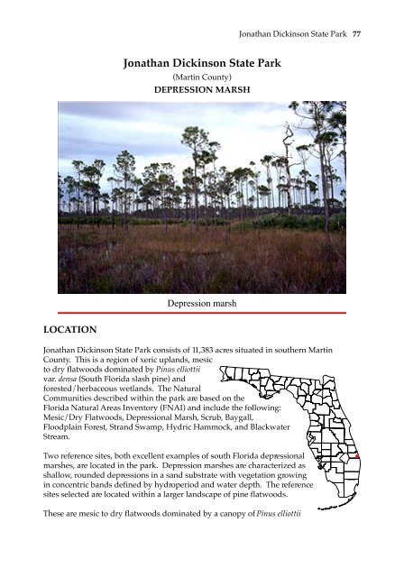
DEPRESSION MARSH<br />
Depression marsh<br />
<strong>Jonathan</strong> <strong>Dickinson</strong> <strong>State</strong> <strong>Park</strong> 77<br />
<strong>Jonathan</strong> <strong>Dickinson</strong> <strong>State</strong> <strong>Park</strong> consists of 11,383 acres situated in southern Martin<br />
County. This is a region of xeric uplands, mesic<br />
to dry flatwoods dominated by Pinus elliottii<br />
var. densa (South Florida slash pine) and<br />
forested/herbaceous wetlands. The Natural<br />
Communities described within the park are based on the<br />
Florida Natural Areas Inventory (FNAI) and include the following:<br />
Mesic/Dry Flatwoods, Depressional Marsh, Scrub, Baygall,<br />
Floodplain Forest, Strand Swamp, Hydric Hammock, and Blackwater<br />
Stream.<br />
Two reference sites, both excellent examples of south Florida depressional<br />
marshes, are located in the park. Depression marshes are characterized as<br />
shallow, rounded depressions in a sand substrate with vegetation growing<br />
in concentric bands defined by hydroperiod and water depth. The reference<br />
sites selected are located within a larger landscape of pine flatwoods.<br />
These are mesic to dry flatwoods dominated by a canopy of Pinus elliottii
78<br />
Mesic pine flatwoods looking upland from wetland boundary of southern marsh<br />
var. densa (South Florida slash pine) and a well developed understory consisting of<br />
Serenoa repens (saw palmetto), Ilex glabra (gallberry), Lyonia lucida (fetterbush), Hypericum<br />
spp.(St. John’s-wort), Ilex cassine (dahoon holly), Myrica cerifera (wax myrtle), and Asimina<br />
reticulata (pawpaw). The herbaceous layer is dominated by Aristida stricta (wiregrass),<br />
Aristida rhizomorpha (Florida three-awn), Pteridium aquilinum (bracken fern), Rhexia<br />
nuttallii (meadowbeauty), Xyris spp.(yellow-eye grass), Carphephorus paniculatus<br />
(carphephorus), Hypoxis juncea (yellow-star grass) and Pterocaulon virgatum (blackroot).<br />
The occurrence of the depressional marshes in this otherwise flat landscape is a factor of<br />
the local topography and soils which prevent rapid runoff or infiltration.<br />
ACCESS<br />
The entrance to <strong>Jonathan</strong> <strong>Dickinson</strong> <strong>State</strong> <strong>Park</strong> is on the west side of U.S. Highway 1 in<br />
southern Martin County, between Hobe Sound and Jupiter. After entering the park,<br />
follow the main road towards the picnic and boating area. The first reference site is<br />
located along the north side of the depressional marsh immediately west of the road as it<br />
turns due south. The second reference site can be reached only by hiking approximately<br />
one quarter mile west on the first access road south of the first reference site. The second<br />
reference site is located along the north side of the depressional marsh southeast of the<br />
road.<br />
GENERAL COMMUNITY CHARACTERIZATION OF BOTH SITES<br />
Both marshes are typical in appearance in being dominated throughout by hydrophytic
<strong>Jonathan</strong> <strong>Dickinson</strong> <strong>State</strong> <strong>Park</strong> 79<br />
plants. The duration of inundation (hydroperiod) influences the dominant plant<br />
communities. Maidencane (Panicum hemitomon) for example, cannot tolerate continuous<br />
flooding and requires a drawdown during a portion of the annual hydroperiod (Kushian<br />
in Ecosystems of Florida, 1991). Thus, it is significant that both reference sites contain<br />
areas dominated by maidencane, usually in the deepest area. A band of St. John’s-wort<br />
(Hypericum fasciculatum) occurs landward of the maidencane zone. The shallow rooted<br />
species, such as St. John’s-wort (Hypericum spp.), are killed by drying and fire but quickly<br />
reseed during wet periods, while rhizomatous species such as maidencane survive these<br />
extremes underground. As a result, zones of dominance migrate up and down slope in<br />
response to changing water conditions (B. H. Winchester, personal communication to<br />
Kushian in Ecosystems of Florida, 1991).<br />
Due to variable soil conditions and hydroperiods the ecotone between marsh and<br />
flatwoods is often reticulate in nature. This is the palmetto “edge” often seen around<br />
depression marshes. It is here that we find the highest diversity of herbaceous plant<br />
species associated with these wetlands. The wetland boundary will most often occur in<br />
this ecotone.<br />
The marshes differ in the degree of slope along the wetland/upland boundary which is<br />
expressed as differences in the vegetative transition within the fringe zone of Serenoa<br />
repens (saw palmetto). The fringing palmetto zone along the northern reference site<br />
consists of patches of Serenoa repens intermixed with areas dominated by grasses or<br />
gallberry. The southern marsh site has a steeper gradient at the edge and a more<br />
apparent community change from the wetland to the upland. The palmetto edge at the<br />
southern reference site is continuous and distinct.<br />
GENERAL DELINEATION PROCEDURE<br />
The marshes chosen as reference sites are identifiable as wetlands by direct use of the<br />
wetland definition. Further, each reference site is represented on the Martin County soil<br />
survey as a depressional mapping unit (Waveland sand, depressional). Areas mapped<br />
in County Soil surveys as frequently flooded or depressional are wetlands contingent on<br />
in-situ confirmation of the hydric soil characteristics (subsection 62-340.300(2)(c), F.A.C.).<br />
Hydric soil indicators within these areas are readily confirmed. Implementing subsection<br />
62-340.300(2)(c), F.A.C., is a technical exercise that most often requires the expertise of a<br />
soil scientist because it is necessary to located the edge of the depressional area as<br />
mapped on the soil map. Once the edge of the depressional unit is located, then the other<br />
provisions of Chapter 62-340, F.A.C., must be examined to discern whether the wetland<br />
being delineated extends landward of the depressional area.<br />
NORTHERN MARSH<br />
• Observations begin in the marsh at the edge of the “Hypericum zone”, a site clearly<br />
within the depressional soil mapping unit. Hypericum fasciculatum is an ecologically<br />
obligate wetland plant which often develops as an apparent broad band of vegetation<br />
within inundated areas of a marsh. Vegetative dominance in this zone meets the<br />
provisions of subsection 62-340.300(2)(a), F.A.C. Further supporting this conclusion, at
80<br />
this location, is the presence of greater than two inches of mucky texture at the soil<br />
surface. Starting at the landward edge of this zone, the dominance of obligate and<br />
facultative wet species is followed landward with a coincident examination for the<br />
presence of the hydric soil indicators and hydrologic indicators. During this progression,<br />
the presence of obligated species became negligible and vegetative dominance shifts to<br />
subsection 62-340.300(2)(b), F.A.C.<br />
• Moving outward into the ecotone, the vegetative pattern became dominated in part by<br />
Northern depression marsh looking in from wetland boundary<br />
large clumps of Serenoa repens (saw palmetto). At this point, using only vegetative<br />
dominance and hydric soil indicators, would produce a sinuous, hydrologically<br />
inconsistent boundary line. The soil profile within the waterward portions of the Serenoa<br />
clumps exhibit at least two inches of mucky texture at the surface indicating the presence<br />
of water at or above the surface for extended periods of time. The depth of mucky<br />
texture decreases moving landward through the Serenoa. By using the provisions of<br />
subsection 62-340.300(2)(d), F.A.C., a consistent line is established for the wetland<br />
boundary.<br />
• The accurate placement of the wetland boundary based upon hydrologic indicators and<br />
not along the landward edge of the Serenoa patches was confirmed by measuring the<br />
elevation of the points along the lines. The waterward edge of the Serenoa clumps do not<br />
occur at a consistent elevation. The elevations of the points consistent with the<br />
hydrologic indicators are well within the range of each other. Placement of the wetland<br />
boundary along the waterward edge of the Serenoa patches for a reticulated vegetative<br />
community of this type would neglect the presence of evidence of inundation above the
Serenoa patches.<br />
<strong>Jonathan</strong> <strong>Dickinson</strong> <strong>State</strong> <strong>Park</strong> 81<br />
The assumed elevations of the five points determining the wetland boundary using<br />
subsection 62-340.300(2)(d), F.A.C., are:<br />
Vegetation within the Marsh<br />
Marsh Interior<br />
Canopy and Subcanopy<br />
#1 9.30' #4 9.36’<br />
#2 9.42’ #5 9.50'<br />
#3 9.44'<br />
Taxodium ascendens OBL pond cypress<br />
Ground cover<br />
Panicum hemitomon OBL maidencane<br />
Hypericum Fringe<br />
Ground cover<br />
Eriocaulon compressum OBL pipewort<br />
Eriocaulon decangulare OBL pipewort<br />
Fuirena scirpoidea OBL umbrella sedge<br />
Hypericum fasciculatum OBL St. Johns wort<br />
Panicum erectifolium OBL erect-leaf witch grass<br />
Xyris spp. OBL yellow-eyed grass<br />
Xyris ambigua OBL yellow-eyed grass<br />
Xyris elliottii OBL yellow-eyed grass<br />
Lycopodium alopecuroides FACW clubmoss<br />
Scleria spp. FACW bald rush<br />
Utricularia spp. OBL bladderwort<br />
Vegetation Immediately Waterward of the Wetland Boundary<br />
Canopy and Subcanopy<br />
Pinus elliottii UPLAND slash pine<br />
Groundcover<br />
Hypericum fasciculatum OBL St. Johns wort<br />
Sphagnum spp. OBL sphagnum moss
82<br />
Utricularia spp. OBL bladderwort<br />
Xyris ambigua OBL yellow-eyed grass<br />
Xyris elliottii OBL yellow-eyed grass<br />
Utricularia subulata OBL bladderwort<br />
Utricularia cornuta OBL bladderwort<br />
Utricularia juncea OBL bladderwort<br />
Andropogon glomeratus FACW broom sedge<br />
Drosera capillaris FACW pink sundew<br />
Panicum dichotomum FACW panicum<br />
Rhynchospora ciliaris FACW beak rush<br />
Rhynchospora fascicularis FACW beak rush<br />
Aristida rhizomophora FAC three-awn grass<br />
Aristida spiciformis FAC three-awn grass<br />
Aristida stricta FAC wire grass<br />
Myrica cerifera FAC wax myrtle<br />
Ilex glabra UPLAND gallberry<br />
Vegetative Immediately Landward of the Wetland Boundary Line<br />
Canopy and Subcanopy<br />
Pinus elliottii UPLAND slash pine<br />
Ground cover<br />
Scleria spp. FACW bald rush<br />
Aristida rhizomophora FAC three-awn grass<br />
Aristida spiciformis FAC three-awn grass<br />
Aristida stricta FAC wire grass<br />
Vegetation In the Upland<br />
Canopy and Subcanopy<br />
Pinus elliottii UPLAND slash pine<br />
Ground cover<br />
Burmannia biflora OBL burmannia<br />
Scleria spp. FACW bald rush<br />
Aristida rhizomophora FAC three awn grass<br />
Aristida stricta FAC wire grass<br />
Schizachyrium scoparium FAC bluestem<br />
Myrica cerifera FAC wax myrtle<br />
Satureja rigida UPLAND pennyroyal<br />
Ilex glabra UPLAND gallberry
SOUTHERN MARSH<br />
<strong>Jonathan</strong> <strong>Dickinson</strong> <strong>State</strong> <strong>Park</strong> 83<br />
• The initial review of the plant communities reveals a distinct break between the outer<br />
area of the depressional marsh, dominated by FACW plant species, and the upland pine<br />
flatwoods, dominated by Serenoa repens. This apparent edge corresponds to a visual<br />
estimate of the landward extent of the depressional mapping unit. Often however, as is<br />
the case here, the true wetland boundary is different from the depressional mapping unit<br />
boundary as depicted in the soil survey. Use of the palmetto edge as an interpretation of<br />
the depressional mapping unit boundary at this site results in a boundary which is not<br />
reflective of a consistent water level as determined by on-site elevations. This would not<br />
be unusual for a seepage area, but in a flatwoods landscape the elevation of the wetland<br />
boundary should, in most cases, be consistent. By using the provisions of subsection 62-<br />
340.300(2)(d), F.A.C. A wetland boundary is established based upon the occurrence of<br />
two or more inches of mucky texture in conjunction with the hydric soil indicators, that<br />
reflects a consistent water level. Portions of this boundary are located slightly landward<br />
of the waterward edge of the saw palmetto.<br />
Vegetation Within The Marsh<br />
Ground cover<br />
Hypericum fasciculatum OBL St. John’s-wort, marsh<br />
Panicum erectifolium OBL witchgrass, erect-leaf<br />
Panicum hemitomon OBL maidencane<br />
Taxodium ascendens OBL cypress, pond<br />
Note: the Hypericum had adventitious rooting. The Taxodium showed signs of fire,<br />
even in the deepest portion of this marsh.<br />
Vegetation Immediately Waterward of the Wetland Boundary<br />
Shallow portions of marsh up to the first stunted Pinus elliottii var. densa and not past the<br />
Serenoa repens. This wetland/upland line is more abrupt as the palmetto is less reticulate<br />
in its growth pattern and the uplands are drier with sandy soils and sandhill vegetation.<br />
Ground cover<br />
Andropogon glomeratus FACW bluestem, bushy<br />
(Campbell)<br />
Aristida spiciformis FAC bottlebrush, three-awn<br />
Balduina atropurpurea FACW honeycomb-head, purple<br />
Bigelowia nudata FACW golden-rod, rayless<br />
Ctenium spp. FACW toothache grass<br />
Cyperus spp. FACW flatsedge
84<br />
Drosera capillaris FACW sundew, pink<br />
Eleocharis baldwinii OBL spikerush<br />
Eriocaulon decangulare OBL pipewort<br />
Fuirena scirpoidea OBL umbrella-sedge<br />
Juncus spp. OBL rush<br />
Lycopodium alopecuroides FACW clubmoss<br />
Oxypolis filiformis OBL water drop-wort<br />
Rhexia petiolata FACW meadow-beauty, white<br />
Rhynchospora tracyi FACW beakrush<br />
Sabatia bartramii OBL rose-gentian, Bartram’s<br />
Sphagnum spp. OBL sphagnum mos<br />
Utricularia subulata OBL bladderwort<br />
Xyris ambigua OBL yellow-eyed grass<br />
Xyris spp. OBL yellow-eyed grass<br />
Vegetation Immediately Landward of the Wetland Boundary<br />
Pine flatwoods. This is a dry pine flatwoods site. It is of note that the palmetto is most<br />
dense at the edge of the wetland.<br />
Canopy<br />
Pinus elliottii var. densa UPLAND So. Florida slash pine<br />
Subcanopy<br />
Pinus elliottii var. densa UPLAND So. Florida slash pine<br />
Ground cover<br />
Andropogon glomeratus FACW bluestem, bushy<br />
(Campbell)<br />
Aristida stricta FAC three-awn grass, pineland<br />
Hypoxis juncea FACW stargrasses, yellow<br />
Ilex glabra UPLAND gallberry<br />
Schizachyrium scoparium FAC bluestem<br />
Scleria reticularis FACW nutrush<br />
Serenoa repens UPLAND saw palmetto<br />
Note: this plant list was compiled during the winter season and some components of the<br />
summer flora will be missing. Also, this area has been burned recently.
SOILS DESCRIPTIONS<br />
NOTHERN MARSH<br />
USDA - NRCS Martin County Soil Survey - Sheet 42<br />
<strong>Jonathan</strong> <strong>Dickinson</strong> <strong>State</strong> <strong>Park</strong> 85<br />
The wetland soil is mapped as Waveland sand, depressional (mapping unit #5).<br />
The upland soil is mapped as Waveland sand (mapping unit #4).<br />
5 - Waveland sand, depressional is composed of:<br />
100% - Waveland soil hydric component<br />
4 - Waveland sand is composed of:<br />
40% - Waveland soil non-hydric component<br />
40% - Immokalee soil non-hydric inclusion<br />
10% - St. Johns soil hydric inclusion<br />
10% - Waveland soil hydric inclusion<br />
Soil Profile Descriptions<br />
Point 2-1. Five-eight feet waterward of the wetland boundary line (inundation present).<br />
Horizon Depth (in)<br />
Oa 0-2 black (10YR 2/1) muck<br />
A 2-3 very dark gray (10YR 3/1) fine sand<br />
E or C 3+ gray (10YR 5/1) fine sand<br />
Hydric soil: Yes<br />
Hydric soil field indicators: presence of two inches of muck in the Oa horizon.
86<br />
Point 2-2<br />
Point 2-2. Six feet waterward of the wetland boundary line (water table - 7 inches).<br />
Horizon Depth (in)<br />
A1 0-4 black (10YR 2/1) mucky sand; many medium roots<br />
A2 4-9 very dark gray (10YR 3/1) sand; few medium and fine roots<br />
E or C 9-15+ gray (10YR 5/1) fine sand; few medium and large roots<br />
Hydric soil: Yes<br />
Hydric soil field indicators: presence of more than two inches of mucky texture (sand) in<br />
the A1 horizon.
Point 2-4a<br />
<strong>Jonathan</strong> <strong>Dickinson</strong> <strong>State</strong> <strong>Park</strong> 87<br />
Point 2-4a. Just waterward of the wetland boundary line (water table - 10 inches).<br />
Horizon Depth (in)<br />
A1 0-2 black (10YR 2/1) mucky sand<br />
A2 2-10 very dark gray (10YR 3/1) sand<br />
E or C 10+ light brownish gray (10YR 6/2) sand<br />
Hydric soil: Yes<br />
Hydric soil field indicators: presence of two inches of mucky texture (sand) in the A1<br />
horizon.
88<br />
Point 2-4b<br />
Point 2-4b. Just landward of the wetland delineation line (water table - 11 inches).<br />
Horizon Depth (in)<br />
A1 0-4 black (10YR 2/1) sand;<br />
A2 4-8 very dark gray (10YR 3/1) and gray (10YR 5/1) sand;<br />
stripped matrix<br />
A3 8-12 dark gray (10YR 4/1) sand<br />
E or C 12+ gray (10YR 6/1) sand<br />
Hydric soil: Yes<br />
Hydric soil field indicators: presence of four inches of greater than 70% coated sand<br />
grains in the A1 horizon.
Point 2-5<br />
Point 2-5. Landward of the wetland boundary line.<br />
<strong>Jonathan</strong> <strong>Dickinson</strong> <strong>State</strong> <strong>Park</strong> 89<br />
Horizon Depth (in)<br />
A1 0-1/2 black (10YR 2/1) mucky sand; few fine roots<br />
A2 1/2-4 very dark gray (10YR 3/1) and gray (10YR 5/1) sand<br />
E or C 4+ dark gray (10YR 4/1) and gray (10YR 6/1) sand<br />
Hydric soil: No<br />
Hydric soil field indicators: no hydric soil field indicators present.
90<br />
SOUTHERN MARSH<br />
USDA - NRCS Martin County Soil Survey - Sheet 42<br />
The wetland soil is mapped as Waveland sand, depressional (mapping unit #5).<br />
The upland soil is mapped as Waveland sand (mapping unit #4).<br />
5 - Waveland sand, depressional is composed of:<br />
100% - Waveland soil hydric component<br />
4 - Waveland sand is composed of:<br />
40% - Waveland soil non-hydric component<br />
40% - Immokalee soil non-hydric inclusion<br />
10% - St. Johns soil hydric inclusion<br />
10% - Waveland soil hydric inclusion<br />
Point 2-2
Soil Profile Descriptions<br />
<strong>Jonathan</strong> <strong>Dickinson</strong> <strong>State</strong> <strong>Park</strong> 91<br />
Point 2-2. Waterward of the wetland boundary line (water table - 7 inches).<br />
Horizon Depth (in)<br />
A1 0-4 black (10YR 2/1) sand<br />
A2 4-11 dark gray (10YR 4/1) sand<br />
E or C 11+ gray (10YR 5/1) sand<br />
Hydric soil: Yes<br />
Hydric soil field indicators: presence of four inches of greater than 70% coated sand<br />
grains in the A1 horizon.<br />
Point 2-3a. Waterward of the wetland boundary line (water table - 9 inches).<br />
Horizon Depth (in)<br />
A1 0-6 black (10YR 2/1) sand<br />
E or C 6+ gray (10YR 5/1) sand<br />
Hydric soil: Yes<br />
Hydric soil field indicators: presence of four inches of greater than 70% coated sand<br />
grains in the A1 horizon.
92<br />
Point 2-3b. Landward of the wetland boundary line.<br />
Horizon Depth (in)<br />
A 0-5 very dark gray (10YR 3/1) and light gray (10YR 7/1) sand<br />
E or C 5+ gray (10YR 5/1) and light gray (10YR 7/1) sand<br />
Hydric soil: No<br />
Hydric soil field indicators: no hydric soil field indicators present.<br />
Point 2-3b
Point 2-4. Landward of the wetland boundary line.<br />
Horizon Depth (in)<br />
A 0-2 gray (10YR 5/1) sand<br />
E or C 2+ gray (10YR 7/1) sand<br />
Hydric soil: No<br />
Hydric soil field indicators: no hydric soil field indicators present.<br />
Point 2-4<br />
<strong>Jonathan</strong> <strong>Dickinson</strong> <strong>State</strong> <strong>Park</strong> 93