

Heathcote-Graytown National Park - Parks Victoria
Heathcote-Graytown National Park - Parks Victoria
Heathcote-Graytown National Park - Parks Victoria

Create successful ePaper yourself
Turn your PDF publications into a flip-book with our unique Google optimized e-Paper software.
p a r k n o t e s<br />
<strong>Heathcote</strong>-<strong>Graytown</strong> <strong>National</strong> <strong>Park</strong><br />
Visitor Guide<br />
Explore gold rush and war era historic features, or simply enjoy the solitude of this<br />
Box-Ironbark bush setting.<br />
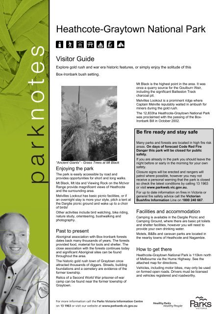
“Ancient Giants” - Grass Trees at Mt Black<br />
Enjoying the park<br />
The park is easily accessible by road and<br />
provides opportunities for short and long walks.<br />
Mt Black, Mt Ida and Viewing Rock on the McIvor<br />
Range provide magnificent views of <strong>Heathcote</strong><br />
and the surrounding area.<br />
Melvilles Lookout has basic picnic facilities, or if<br />
an overnight stay is more your style, pitch a tent at<br />
the Dargile picnic ground and wake up to a choir<br />
of birds!<br />
Other activities include bird watching, bike riding,<br />
nature study, orienteering, bushwalking and<br />
photography.<br />
Past to present<br />
Aboriginal association with Box-Ironbark forests<br />
dates back many thousands of years. The forests<br />
provided food, material for tools and shelter. The<br />
close association with the forests continues today<br />
and significant Aboriginal sites can be found<br />
throughout the area.<br />
The historic gold rush town of <strong>Graytown</strong> once<br />
attracted thousands of diggers. Streets, building<br />
foundations and a cemetery are evidence of the<br />
former township.<br />
Relics of a Second World War prisoner-of-war<br />
camp can be found near the former township of<br />
<strong>Graytown</strong>.<br />
For more information call the <strong>Park</strong>s <strong>Victoria</strong> Information Centre<br />
on 13 1963 or visit our website at www.parkweb.vic.gov.au<br />
Mt Black is the highest point in the area. It was<br />
once a quarry source for the Goulburn Weir,<br />
including the significant Bailieston Track<br />
charcoal pit.<br />
Melvilles Lookout is a prominent ridge where<br />
Captain Melville reputably waited in ambush for<br />
miners during the gold rush.<br />
The 12,833ha <strong>Heathcote</strong>-<strong>Graytown</strong> <strong>National</strong> <strong>Park</strong><br />
was proclaimed with the passing of the Box-<br />
Ironbark Bill in October 2002.<br />
Be fire ready and stay safe<br />
Many parks and forests are located in high fire risk<br />
areas. On days of forecast Code Red Fire<br />
Danger this park will be closed for public<br />
safety.<br />
If you are already in the park you should leave the<br />
night before or early in the morning for your own<br />
safety.<br />
Closure signs will be erected and rangers will<br />
patrol where possible, however you may not<br />
receive a personal warning that the park is closed<br />
so check the latest conditions by calling 13 1963<br />
or visit www.parkweb.vic.gov.au.<br />
For up to date information on fires in <strong>Victoria</strong> or<br />
general fire safety advice call the <strong>Victoria</strong>n<br />
Bushfire Information Line on 1800 240 667.<br />
Facilities and accommodation<br />
Camping is available in the Dargile Picnic and<br />
Camping Ground, where there are basic pit toilets<br />
and shelter facilities, however you will need to<br />
provide your own drinking water.<br />
Motels, B&Bs and caravan parks are located in<br />
the nearby towns of <strong>Heathcote</strong> and Nagambie.<br />
How to get there<br />
<strong>Heathcote</strong>-<strong>Graytown</strong> <strong>National</strong> <strong>Park</strong> is 110km north<br />
of Melbourne via the Hume Highway. See the<br />
attached map for directions.<br />
Vehicles, including motor bikes, may only be used<br />
on formed open roads. Drivers must be licensed<br />
and vehicles registered and roadworthy.
t Creek<br />
HEEHAN TK<br />
ARLANE TK<br />
GIBB TK<br />
ANDMER TK<br />
GLAD TK<br />
NICKS TK<br />
ROSBIE RD<br />
LIFFS LA<br />
Gully<br />
Trilobite<br />
NE EYE RD<br />
MUD HUT TK<br />
Clarks Gully<br />
LA<br />
HANLEY TK<br />
rsons Gully<br />
KYNETON<br />
BACK<br />
ROAD<br />
HIRD TK<br />
To Tooleen,<br />
Elmore<br />
NORTHERN<br />
UNNAMED<br />
82<br />
ROAD<br />
MT IDA<br />
COLBINABBIN RANGE<br />
CROSBIE<br />
NATURE<br />
CONSERVATION<br />
RESERVE<br />
Sheep<br />
B75<br />
Mount<br />
Ida Mount<br />
Ida<br />
l<br />
McIvor<br />
Ladys<br />
Creek<br />
Mount<br />
Station<br />
HIGHWAY<br />
HEATHCOTE<br />
RECREATION<br />
RESERVE<br />
PINK CLIFFS<br />
GEOLOGICAL<br />
RESERVE<br />
RANGE<br />
<strong>Heathcote</strong><br />
SPRING PLAINS<br />
NATURE<br />
CONSERVATION<br />
RESERVE<br />
RODNEY TK<br />
GORMANS<br />
UNNAMED<br />
80<br />
MOUNT IDA RANGE<br />
CAHILLS<br />
TK<br />
DRIVE<br />
FOREST<br />
MT CAMEL<br />
MEAKER<br />
TK<br />
PANNELLS<br />
PLANTATION<br />
BUTLER CRT<br />
TRAVERS LA<br />
HEENANS LA<br />
Dirty Womans Gully<br />
HEENANS LA<br />
JACKAS LA<br />
BONNEYS BONNEYS LA LA<br />
PETERS GULLY RD<br />
Rosy Gully RING TK<br />
SHORTS LA<br />
Caledonia JOES Gully RD PETERS GULLY RD<br />
TK<br />
DARGILE<br />
RODNEY TK<br />
UNNAMED<br />
79<br />
UNNAMED<br />
80<br />
SOUTH MT IDA<br />
TK<br />
Ida<br />
HEATHCOTE<br />
NORTHERN<br />
TK<br />
Creek<br />
McIVOR RANGE<br />
Argyle<br />
Cornella<br />
B75<br />
HEATHCOTE<br />
Creek<br />
HYLANDS<br />
TK<br />
DRIVE<br />
Creek<br />
C347<br />
MANSEYS<br />
TK<br />
Viewing<br />
Rock<br />
Lookout<br />
TK<br />
WILLIAM<br />
TK<br />
PANNELLS<br />
TK<br />
HWY<br />
ROCHESTER<br />
Creek<br />
Cornella<br />
ROAD<br />
GRAYTOWN<br />
ROAD<br />
NORTH<br />
Antimony<br />
LANG<br />
To Colbinabbin,<br />
Rochester<br />
CHAMBERLAIN RD<br />
Creek<br />
OLD EICKERTS HEATHCOTE LA RD HAMILTON CONNALY TK LA<br />
CONNALLYS LA<br />
DONELLYS<br />
LANE<br />
PADDY<br />
SHIPPY<br />
TK<br />
PAVEYS<br />
DAMPER<br />
PLANTATION<br />
TK<br />
C344<br />
Redcastle<br />
Creek<br />
<strong>Heathcote</strong><br />
Powder Magazine<br />
To Tooborac<br />
Creek<br />
Redcastle<br />
ROAD<br />
TK<br />
TRACK<br />
DAM<br />
OLD HEATHCOTE RD<br />
CHAPMAN RD<br />
CROSSING<br />
STONEY<br />
GULLY<br />
DAMPER<br />
TRACK<br />
TK<br />
TK<br />
Dargile Camping &<br />
Picnic Area<br />
COSTERFIELD<br />
Creek<br />
PLONK<br />
OLD<br />
ROAD<br />
ALIEN CAMP TRACK<br />
COACH<br />
HAMILTON TK<br />
GULLY TRACK<br />
ROAD<br />
JIM TK<br />
ROAD<br />
COSTERFIELD<br />
ETHERIDGE CRT<br />
MCCARTHY DR<br />
BRENNAN RD<br />
REDCASTLE<br />
SUZY<br />
TK<br />
DOOLAN CR<br />
FIELD RD<br />
WAPPENTAKE LA<br />
PAVEYS<br />
TOLSHER TK<br />
Costerfield<br />
South<br />
HEATHCOTE<br />
ROAD<br />
Splitters<br />
NAGAMBIE<br />
Costerfield<br />
GROVE WHITE TK<br />
HUGGARD TK<br />
PANGRAZIO TK<br />
MCCARTHY<br />
LINK<br />
NEILSON<br />
TK<br />
COSTERFIELD<br />
NATURE<br />
CONSERVATION<br />
RESERVE<br />
ROAD<br />
TK<br />
Creek<br />
CHERRY<br />
ROAD<br />
GLEESONS<br />
LANE<br />
GLEESONS LANE<br />
TREE<br />
MANSBRIDGE<br />
MT CAMEL<br />
C344<br />
RAGULUS RD<br />
RICE<br />
Garden<br />
Wappentake<br />
Major Creek<br />
BOUNDARY<br />
TK<br />
TK<br />
MCKENZIES<br />
TRACK<br />
TRACK<br />
GRAYTOWN<br />
MOORMBOOL<br />
Hut<br />
TOOBORAC-MAJORS LINE RD<br />
Creek<br />
CHERRY<br />
BRO<br />
ODEAS LA<br />
K<br />
ROA<br />
Ring-tailed<br />
seen at nig<br />
<strong>Heathcote</strong>-<br />
<strong>National</strong> Pa
TREE ROAD<br />
TATTERSALLS LANE<br />
ings Cross<br />
SCRUBBY<br />
Compton<br />
Creek<br />
D<br />
WNES LA<br />
TK<br />
ROAD<br />
FOUR<br />
DARROCHS<br />
Moormbool<br />
West<br />
ROAD<br />
ROAD<br />
MILE RD<br />
TRACK<br />
DARROCHS<br />
Spring Creek<br />
Creek<br />
Back Creek<br />
possums can be<br />
ht around the<br />
<strong>Graytown</strong><br />
rk<br />
ROAD<br />
KILCURRAN DAM RD<br />
LANE<br />
FOUR<br />
MILE<br />
WILLYANS<br />
UNNAMED 97<br />
Mt Moormbool l<br />
ROAD<br />
UNNAMED<br />
98<br />
SPRING CREEK<br />
RD <strong>Graytown</strong><br />
GRAYTOWN-<br />
RUSHWORTH<br />
Major<br />
ST<br />
South<br />
Boundary<br />
Spring<br />
ROAD<br />
ROAD<br />
GRAYTOWN<br />
Creek<br />
ROAD<br />
RUSHWORTH<br />
BAILIESTON<br />
OLD<br />
FREISLAND<br />
JOHNSTONS<br />
Melvilles<br />
Lookout<br />
<strong>Graytown</strong><br />
Cemetery<br />
GRAYTOWN<br />
SURFACE<br />
CEMETERY RD<br />
SOUTH BOUNDARY<br />
MOUNT BLACK<br />
REFERENCE<br />
AREA<br />
SEYMOUR<br />
UNNAMED<br />
25<br />
RD<br />
REEF<br />
ROAD<br />
<strong>Graytown</strong><br />
POW Camp<br />
Compton<br />
HILLS RD<br />
HILL<br />
ROAD<br />
ROAD<br />
TIN<br />
FREISLAND<br />
MT MELVILLE<br />
RD<br />
PUCKAPUNYAL MILITARY AREA<br />
Creek<br />
RD<br />
RD<br />
TODDS RD<br />
Franks Creek<br />
Creek<br />
MT BLACK<br />
SPRING CREEK<br />
NATURE<br />
CONSERVATION<br />
RESERVE<br />
HUT TK<br />
l Mt Black<br />
GRAYTOWN<br />
CEMETERY<br />
RESERVE<br />
HEATHCOTE<br />
QUARRY<br />
Elmore<br />
l<br />
MIDLAND<br />
McIVOR<br />
l<br />
Bendigo<br />
RD<br />
MITCHELLSTOWN<br />
HWY<br />
NORTHERN<br />
BAILIESTON<br />
Mount Black<br />
Quarry<br />
UNNAMED<br />
2<br />
C344<br />
Kyabram l<br />
l <strong>Heathcote</strong><br />
HWY<br />
HEATHCOTE-<br />
GRAYTOWN<br />
NATIONAL PARK<br />
Seymour<br />
l<br />
HWY<br />
HUME<br />
Gardiner Creek<br />
Sandy<br />
ROAD<br />
UNNAMED<br />
1<br />
Gardiner lNagambie<br />
Creek<br />
GOULBURN<br />
VALLEY<br />
HWY<br />
FWY<br />
Creek<br />
NAGAMBIE<br />
l<br />
HI<br />
ROAD<br />
VERGES LA<br />
RUSHWORTH NAGAMBIE<br />
ROAD<br />
Hawker Creek<br />
Bailieston<br />
BAILIESTON<br />
HISTORIC AREA<br />
ROAD<br />
BAILIESTON<br />
HISTORIC AREA BAILIESTON<br />
BUSHLAND<br />
RESERVE<br />
To Mitchellstown<br />
To Nagambie<br />
<strong>Heathcote</strong>-<strong>Graytown</strong><br />
<strong>National</strong> <strong>Park</strong><br />
ã<br />
N<br />
Highway<br />
Sealed road<br />
Major unsealed road<br />
Minor unsealed road<br />
Management Vehicle<br />
Only road<br />
Vehicle track (4WD)<br />
<strong>National</strong> <strong>Park</strong><br />
Other Reserves<br />
Reference Area<br />
-No Public Access<br />
State Forest<br />
Commonwealth Land<br />
Dog Walking area<br />
Recreational<br />
Facilities<br />
Camping<br />
Fireplace<br />
Lookout<br />
<strong>Park</strong> information<br />
Picnic shelter<br />
Picnic table<br />
Toilets<br />
0 1 2<br />
KILOMETRES<br />
Cartography by Spatial Vision 2008<br />
M/7622<br />
H<br />
l MELBOURNE<br />
©
For further information<br />
<strong>Park</strong>s <strong>Victoria</strong><br />
Information Centre<br />
Call 13 1963<br />
or visit the<br />
<strong>Park</strong>s <strong>Victoria</strong> website<br />
www.parkweb.vic.gov.au<br />
<strong>Heathcote</strong> Visitor<br />
Information Centre<br />
Cnr High and Barrack Streets<br />
<strong>Heathcote</strong> Vic 3523<br />
Phone: 03 5433 3121<br />
Nagambie Lakes Visitor<br />
Information Centre<br />
145 High Street<br />
Nagambie Vic 3608<br />
Freecall: 1800 444 647<br />
Caring for the<br />
environment<br />
Help us look after your park<br />
by following these guidelines:<br />
Please take rubbish home with<br />
you for recycling or disposal<br />
All native plants, animals,<br />
historical and archaeological<br />
sites and geographic features<br />
are protected by law<br />
Dogs are only permitted in the<br />
McIvor Range area (marked on<br />
the map) and must be kept on a<br />
leash at all times.<br />
Firearms are prohibited<br />
Prospecting is permitted in<br />
designated areas. Prospectors<br />
must hold a current Miner's<br />
Right. Refer to the Prospecting<br />
Guide for more information<br />
Light fires only in fireplaces<br />
provided. Bring your own<br />
firewood for barbecues. Gas<br />
barbecues are recommended<br />
No fires, including gas<br />
barbecues, may be lit on a day<br />
of Total Fire Ban.<br />
<strong>Heathcote</strong>-<strong>Graytown</strong> <strong>National</strong><br />
<strong>Park</strong> is in the Northern<br />
Country Total Fire Ban<br />
District. It is your<br />
responsibility to know if it is<br />
a day of Total Fire Ban. If in<br />
doubt call the <strong>Victoria</strong>n<br />
Bushfire Information Line on<br />
1800 240 667<br />
<strong>Park</strong> closures - Be prepared to<br />
leave early as extreme<br />
weather may cause the<br />
closure of some park areas<br />
for public safety<br />
Healthy <strong>Park</strong>s Healthy People<br />
Visiting a park can improve<br />
your health, mind, body and<br />
soul. So, with over four million<br />
hectares of parkland available<br />
to <strong>Victoria</strong>ns, why not escape<br />
to a park today!<br />
Plants and animals<br />
The park includes eight large old tree sites. Red<br />
Ironbark, Grey Box and Yellow Box are the<br />
predominant trees in these areas.<br />
Sixteen threatened species have been recorded in<br />
the park, including the Crimson Spider-Orchid,<br />
Clover Glycine, Scented Bush Pea, Squirrel<br />
Glider, Powerful Owl, Bandy Bandy and Swift<br />
Parrots.<br />
Other birds and animals you can see include the<br />
White Breasted Sea Eagle, Swamp Wallaby,<br />
Yellow Footed Antechinus, Bearded Dragon,<br />
Barking Gecko and the Sugar Glider.<br />
Barking Gecko – Jeremy Tscharke<br />
Other interesting places to visit<br />
Pink Cliffs<br />
This interesting and colourful phenomenon was<br />
created by early gold-mining activities. Sluicing<br />
work was carried out until the early 1880s and it<br />
was in this period that work in the Pink Cliffs area<br />
brought to light these colourful “hills”.<br />
From the Northern Highway, follow Jennings<br />
Street to the west, turn south onto Hospital Street,<br />
then west onto Pink Cliffs Road and follow<br />
directional signs.<br />
Viewing Rock<br />
From here you can take in a fantastic view of<br />
<strong>Heathcote</strong>, which is reputed to have the longest<br />
main street in the southern hemisphere. Take a<br />
hike down to the Powder Magazine, witness a<br />
spectacular array of orchids, or just sit and listen<br />
to the harmony of the Grey Shrike Thrush.<br />
Heading North along the Northern Highway turn<br />
east onto Chauncey Street, drive past the<br />
Showgrounds and turn north on to the North<br />
Costerfield Road and then to the east of the<br />
Range Drive and simply follow the signs.<br />
<strong>Heathcote</strong> Powder Magazine<br />
This English style masonry brick building was<br />
used in the 1860s to house gunpowder and<br />
explosives for the McIvor Diggings Gold Rush.<br />
Simply follow Barrack Road to the East (off the<br />
Northern Highway), turn right before the caravan<br />
park into Forest Drive and follow the directional<br />
signs.<br />
Mt Ida<br />
Imagine you are sitting on the top of the world<br />
where <strong>Victoria</strong>’s remaining Box-Ironbark forests<br />
disappear into the hazy horizon in all directions.<br />
Views from Mt Ida should inspire even the hardest<br />
to please outdoor enthusiast.<br />
Stay on the Northern Highway heading north<br />
approximately 8kms and follow the directional<br />
signs all the way to the carpark.<br />
December 2010<br />
Printed on Australian-made 100% recycled paper


