Quicklook Report 2001 - People Server at UNCW
Quicklook Report 2001 - People Server at UNCW
Quicklook Report 2001 - People Server at UNCW

You also want an ePaper? Increase the reach of your titles
YUMPU automatically turns print PDFs into web optimized ePapers that Google loves.
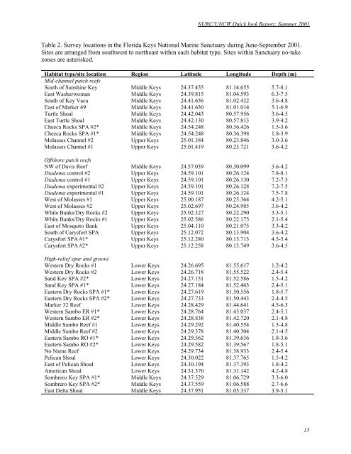
NURC/<strong>UNCW</strong> Quick look <strong>Report</strong>: Summer <strong>2001</strong><br />
Table 2. Survey loc<strong>at</strong>ions in the Florida Keys N<strong>at</strong>ional Marine Sanctuary during June-September <strong>2001</strong>.<br />
Sites are arranged from southwest to northeast within each habit<strong>at</strong> type. Sites within Sanctuary no-take<br />
zones are asterisked.<br />
Habit<strong>at</strong> type/site loc<strong>at</strong>ion Region L<strong>at</strong>itude Longitude Depth (m)<br />
Mid-channel p<strong>at</strong>ch reefs<br />
South of Sunshine Key Middle Keys 24.37.455 81.14.655 5.7-8.1<br />
East Washerwoman Middle Keys 24.39.815 81.04.593 6.3-7.5<br />
South of Key Vaca Middle Keys 24.41.656 81.02.432 3.6-4.8<br />
East of Marker 49 Middle Keys 24.41.630 81.01.014 5.1-6.9<br />
Turtle Shoal Middle Keys 24.42.043 80.57.956 3.6-4.5<br />
East Turtle Shoal Middle Keys 24.42.130 80.57.813 3.9-4.2<br />
Cheeca Rocks SPA #2* Middle Keys 24.54.248 80.36.426 1.5-3.6<br />
Cheeca Rocks SPA #1* Middle Keys 24.54.248 80.36.398 1.8-3.9<br />
Molasses Channel #2 Upper Keys 25.01.384 80.23.846 3.0-3.6<br />
Molasses Channel #1 Upper Keys 25.01.419 80.23.721 3.6-4.2<br />
Offshore p<strong>at</strong>ch reefs<br />
NW of Davis Reef Middle Keys 24.57.039 80.30.099 3.6-4.2<br />
Diadema control #2 Upper Keys 24.59.101 80.26.124 7.8-8.1<br />
Diadema control #1 Upper Keys 24.59.101 80.26.130 7.2-7.5<br />
Diadema experimental #2 Upper Keys 24.59.101 80.26.128 7.2-7.5<br />
Diadema experimental #1 Upper Keys 24.59.101 80.26.124 7.5-7.8<br />
West of Molasses #1 Upper Keys 25.00.187 80.25.364 4.2-5.1<br />
West of Molasses #2 Upper Keys 25.02.697 80.24.985 3.6-4.2<br />
White Banks/Dry Rocks #2 Upper Keys 25.02.327 80.22.290 3.3-5.1<br />
White Banks/Dry Rocks #1 Upper Keys 25.02.586 80.22.175 2.1-5.4<br />
East of Mosquito Bank Upper Keys 25.04.110 80.21.075 3.3-4.2<br />
South of Carysfort SPA Upper Keys 25.12.072 80.13.904 3.6-4.2<br />
Carysfort SPA #1* Upper Keys 25.12.280 80.13.713 4.5-5.4<br />
Carysfort SPA #2* Upper Keys 25.12.258 80.13.749 3.6-4.5<br />
High-relief spur and groove<br />
Western Dry Rocks #1 Lower Keys 24.26.695 81.55.617 1.2-4.2<br />
Western Dry Rocks #2 Lower Keys 24.26.718 81.55.522 2.4-5.4<br />
Sand Key SPA #2* Lower Keys 24.27.151 81.52.586 1.5-4.2<br />
Sand Key SPA #1* Lower Keys 24.27.184 81.52.463 2.4-5.1<br />
Eastern Dry Rocks SPA #1* Lower Keys 24.27.619 81.50.556 1.8-5.7<br />
Eastern Dry Rocks SPA #2* Lower Keys 24.27.733 81.50.443 2.4-4.5<br />
Marker 32 Reef Lower Keys 24.28.429 81.44.641 4.5-6.3<br />
Western Sambo ER #1* Lower Keys 24.28.764 81.43.037 2.4-5.1<br />
Western Sambo ER #2* Lower Keys 24.28.838 81.42.720 2.1-4.8<br />
Middle Sambo Reef #1 Lower Keys 24.29.292 81.40.554 1.5-4.8<br />
Middle Sambo Reef #2 Lower Keys 24.29.378 81.40.304 2.1-4.5<br />
Eastern Sambo RO #1* Lower Keys 24.29.562 81.39.636 1.8-3.6<br />
Eastern Sambo RO #2* Lower Keys 24.29.582 81.39.567 1.8-5.1<br />
No Name Reef Lower Keys 24.29.734 81.38.933 2.4-5.4<br />
Pelican Shoal Lower Keys 24.30.022 81.37.765 1.5-4.2<br />
East of Pelican Shoal Lower Keys 24.30.194 81.37.393 1.8-4.2<br />
American Shoal Lower Keys 24.31.370 81.31.142 4.2-4.8<br />
Sombrero Key SPA #1* Middle Keys 24.37.529 81.06.729 3.3-6.0<br />
Sombrero Key SPA #2* Middle Keys 24.37.559 81.06.588 2.7-6.6<br />
East Delta Shoal Middle Keys 24.37.951 81.05.337 3.9-5.1<br />
15