Quicklook Report 2001 - People Server at UNCW
Quicklook Report 2001 - People Server at UNCW
Quicklook Report 2001 - People Server at UNCW

You also want an ePaper? Increase the reach of your titles
YUMPU automatically turns print PDFs into web optimized ePapers that Google loves.
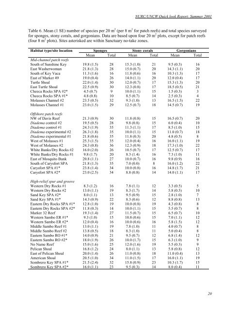
NURC/<strong>UNCW</strong> Quick look <strong>Report</strong>: Summer <strong>2001</strong><br />
Table 6. Mean (1 SE) number of species per 20 m 2 (per 8 m 2 for p<strong>at</strong>ch reefs) and total species surveyed<br />
for sponges, stony corals, and gorgonians. D<strong>at</strong>a are based upon four 20 m 2 plots, except for p<strong>at</strong>ch reefs<br />
(four 8 m 2 plots). Sites asterisked are within Sanctuary no-take zones.<br />
Habit<strong>at</strong> type/site loc<strong>at</strong>ion Sponges Stony corals Gorgonians<br />
Mean Total Mean Total Mean Total<br />
Mid-channel p<strong>at</strong>ch reefs<br />
South of Sunshine Key 19.8 (1.5) 28 15.3 (1.0) 21 9.5 (0.3) 16<br />
East Washerwoman 21.8 (1.3) 28 15.0 (0.7) 20 14.3 (1.1) 20<br />
South of Key Vaca 11.3 (1.6) 16 11.8 (0.6) 16 10.3 (1.3) 17<br />
East of Marker 49 19.0 (0.4) 26 14.0 (1.1) 20 12.0 (0.4) 17<br />
Turtle Shoal 22.0 (1.4) 30 12.0 (0.7) 17 15.3 (1.3) 20<br />
East Turtle Shoal 22.5 (0.9) 30 12.3 (0.8) 17 18.5 (0.5) 21<br />
Cheeca Rocks SPA #2* 4.5 (0.7) 9 10.0 (1.1) 15 1.5 (0.3) 3<br />
Cheeca Rocks SPA #1* 4.8 (0.8) 10 8.5 (0.7) 14 2.5 (0.3) 4<br />
Molasses Channel #2 23.5 (0.5) 32 9.3 (1.0) 13 16.5 (1.5) 22<br />
Molasses Channel #1 23.0 (1.5) 29 12.5 (0.7) 18 14.5 (0.7) 19<br />
Offshore p<strong>at</strong>ch reefs<br />
NW of Davis Reef 21.3 (0.9) 30 11.8 (0.8) 15 16.5 (0.7) 20<br />
Diadema control #2 19.5 (0.5) 28 9.8 (0.8) 15 6.0 (0.4) 10<br />
Diadema control #1 24.3 (1.9) 35 11.3 (1.1) 17 8.5 (1.0) 15<br />
Diadema experimental #2 26.3 (1.8) 35 10.0 (1.1) 15 11.0 (0.7) 18<br />
Diadema experimental #1 21.8 (0.6) 35 11.8 (0.3) 20 4.8 (0.5) 8<br />
West of Molasses #1 25.3 (1.5) 35 12.0 (0.4) 16 16.0 (1.1) 19<br />
West of Molasses #2 24.3 (0.8) 36 12.3 (0.9) 18 17.3 (1.0) 22<br />
White Banks/Dry Rocks #2 16.0 (2.0) 26 10.5 (0.7) 17 12.5 (0.7) 17<br />
White Banks/Dry Rocks #1 9.8 (1.7) 20 8.3 (1.4) 16 7.3 (1.0) 11<br />
East of Mosquito Bank 20.8 (1.1) 27 10.0 (0.7) 16 9.8 (0.9) 16<br />
South of Carysfort SPA 21.8 (1.3) 35 7.0 (0.0) 8 16.0 (1.2) 22<br />
Carysfort SPA #1* 23.8 (1.4) 34 10.0 (0.8) 16 14.8 (1.7) 21<br />
Carysfort SPA #2* 23.0 (2.5) 34 8.8 (0.8) 14 14.0 (1.1) 17<br />
High-relief spur and groove<br />
Western Dry Rocks #1 8.3 (1.2) 16 7.8 (1.1) 12 3.3 (0.5) 5<br />
Western Dry Rocks #2 13.0 (1.1) 19 8.3 (1.7) 14 5.8 (0.5) 10<br />
Sand Key SPA #2* 8.0 (1.1) 13 9.5 (0.9) 15 2.8 (1.0) 7<br />
Sand Key SPA #1* 14.3 (0.9) 22 8.3 (0.6) 12 8.8 (0.8) 13<br />
Eastern Dry Rocks SPA #1* 12.8 (1.0) 19 10.0 (0.8) 19 4.3 (0.8) 8<br />
Eastern Dry Rocks SPA #2* 11.8 (0.3) 14 10.0 (1.1) 15 5.5 (0.7) 8<br />
Marker 32 Reef 19.3 (1.4) 27 11.5 (0.7) 15 6.5 (0.7) 10<br />
Western Sambo ER #1* 9.3 (1.0) 15 10.8 (0.6) 15 7.0 (1.1) 12<br />
Western Sambo ER #2* 12.0 (0.4) 16 10.0 (0.6) 16 5.8 (1.5) 12<br />
Middle Sambo Reef #1 13.0 (1.1) 19 7.8 (1.0) 11 4.0 (0.7) 8<br />
Middle Sambo Reef #2 13.8 (0.5) 18 8.3 (1.0) 11 5.0 (0.4) 8<br />
Eastern Sambo RO #1* 14.0 (0.9) 21 9.5 (0.7) 12 6.8 (1.4) 12<br />
Eastern Sambo RO #2* 18.0 (1.9) 26 10.0 (1.7) 15 6.3 (1.0) 9<br />
No Name Reef 15.0 (1.6) 25 12.0 (1.6) 19 5.5 (0.3) 9<br />
Pelican Shoal 16.8 (1.2) 24 8.0 (1.1) 13 5.8 (0.8) 12<br />
East of Pelican Shoal 20.0 (1.4) 26 11.0 (0.8) 18 11.0 (0.4) 13<br />
American Shoal 20.5 (1.0) 34 11.0 (1.5) 17 16.0 (1.1) 19<br />
Sombrero Key SPA #1* 21.5 (2.4) 32 15.8 (0.9) 23 10.3 (1.7) 15<br />
Sombrero Key SPA #2* 16.0 (1.1) 23 9.5 (0.3) 14 8.0 (0.4) 11<br />
20