Quicklook Report 2001 - People Server at UNCW
Quicklook Report 2001 - People Server at UNCW
Quicklook Report 2001 - People Server at UNCW

Create successful ePaper yourself
Turn your PDF publications into a flip-book with our unique Google optimized e-Paper software.
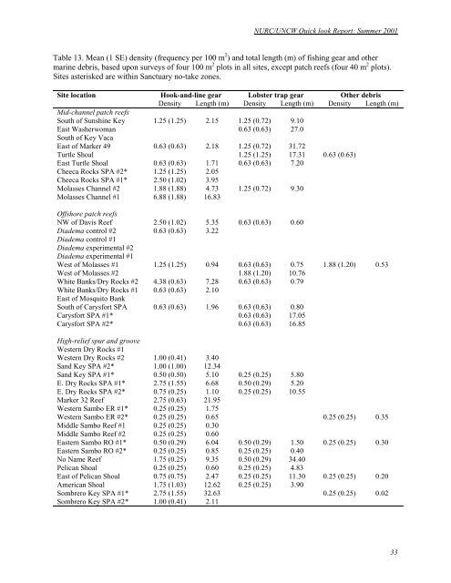
NURC/<strong>UNCW</strong> Quick look <strong>Report</strong>: Summer <strong>2001</strong><br />
Table 13. Mean (1 SE) density (frequency per 100 m 2 ) and total length (m) of fishing gear and other<br />
marine debris, based upon surveys of four 100 m 2 plots in all sites, except p<strong>at</strong>ch reefs (four 40 m 2 plots).<br />
Sites asterisked are within Sanctuary no-take zones.<br />
Site loc<strong>at</strong>ion Hook-and-line gear Lobster trap gear Other debris<br />
Density Length (m) Density Length (m) Density Length (m)<br />
Mid-channel p<strong>at</strong>ch reefs<br />
South of Sunshine Key 1.25 (1.25) 2.15 1.25 (0.72) 9.10<br />
East Washerwoman 0.63 (0.63) 27.0<br />
South of Key Vaca<br />
East of Marker 49 0.63 (0.63) 2.18 1.25 (0.72) 31.72<br />
Turtle Shoal 1.25 (1.25) 17.31 0.63 (0.63)<br />
East Turtle Shoal 0.63 (0.63) 1.71 0.63 (0.63) 7.20<br />
Cheeca Rocks SPA #2* 1.25 (1.25) 2.05<br />
Cheeca Rocks SPA #1* 2.50 (1.02) 3.95<br />
Molasses Channel #2 1.88 (1.88) 4.73 1.25 (0.72) 9.30<br />
Molasses Channel #1 6.88 (1.88) 16.83<br />
Offshore p<strong>at</strong>ch reefs<br />
NW of Davis Reef 2.50 (1.02) 5.35 0.63 (0.63) 0.60<br />
Diadema control #2 0.63 (0.63) 3.22<br />
Diadema control #1<br />
Diadema experimental #2<br />
Diadema experimental #1<br />
West of Molasses #1 1.25 (1.25) 0.94 0.63 (0.63) 0.75 1.88 (1.20) 0.53<br />
West of Molasses #2 1.88 (1.20) 10.76<br />
White Banks/Dry Rocks #2 4.38 (0.63) 7.28 0.63 (0.63) 0.79<br />
White Banks/Dry Rocks #1 0.63 (0.63) 2.10<br />
East of Mosquito Bank<br />
South of Carysfort SPA 0.63 (0.63) 1.96 0.63 (0.63) 0.80<br />
Carysfort SPA #1* 0.63 (0.63) 17.05<br />
Carysfort SPA #2* 0.63 (0.63) 16.85<br />
High-relief spur and groove<br />
Western Dry Rocks #1<br />
Western Dry Rocks #2 1.00 (0.41) 3.40<br />
Sand Key SPA #2* 1.00 (1.00) 12.34<br />
Sand Key SPA #1* 0.50 (0.50) 5.10 0.25 (0.25) 5.80<br />
E. Dry Rocks SPA #1* 2.75 (1.55) 6.68 0.50 (0.29) 5.20<br />
E. Dry Rocks SPA #2* 0.75 (0.25) 1.10 0.25 (0.25) 10.55<br />
Marker 32 Reef 2.75 (0.63) 21.95<br />
Western Sambo ER #1* 0.25 (0.25) 1.75<br />
Western Sambo ER #2* 0.25 (0.25) 0.65 0.25 (0.25) 0.35<br />
Middle Sambo Reef #1 0.25 (0.25) 0.30<br />
Middle Sambo Reef #2 0.25 (0.25) 0.60<br />
Eastern Sambo RO #1* 0.50 (0.29) 6.04 0.50 (0.29) 1.50 0.25 (0.25) 0.30<br />
Eastern Sambo RO #2* 0.25 (0.25) 0.85 0.25 (0.25) 0.40<br />
No Name Reef 1.75 (0.25) 9.35 0.50 (0.29) 34.40<br />
Pelican Shoal 0.25 (0.25) 0.60 0.25 (0.25) 4.83<br />
East of Pelican Shoal 0.75 (0.75) 2.47 0.25 (0.25) 11.30 0.25 (0.25) 0.20<br />
American Shoal 1.75 (1.03) 12.62 0.25 (0.25) 3.90<br />
Sombrero Key SPA #1* 2.75 (1.55) 32.63 0.25 (0.25) 0.02<br />
Sombrero Key SPA #2* 1.00 (0.41) 2.11<br />
33