Waikiki Beach: History of its transformation - Hawaii.gov
Waikiki Beach: History of its transformation - Hawaii.gov
Waikiki Beach: History of its transformation - Hawaii.gov

Create successful ePaper yourself
Turn your PDF publications into a flip-book with our unique Google optimized e-Paper software.
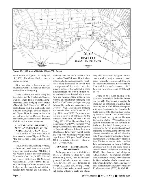
Figure 10. 1907 Map <strong>of</strong> <strong>Waikiki</strong> (Chas. V.E. Dove).<br />
aerial photos <strong>of</strong> Figures 15 (1919) and<br />
19 (1932). The channel had become a<br />
swimming basin.<br />
At a later date, a beach was constructed<br />
seaward <strong>of</strong> the seawall. This will<br />
be described subsequently.<br />
There is almost no beach along the<br />
shore in front <strong>of</strong> the Halekulani-Sheraton<br />
<strong>Waikiki</strong> Hotels. This is probably a longterm<br />
effect <strong>of</strong> the dredging. Note the lack<br />
<strong>of</strong> beach in the 2 November 1932 aerial<br />
photo, Figure 19. Little sand can be seen<br />
in recent photographs such as Figure 1<br />
and Figure 14, or in many earlier photos.<br />
In Figure 1, Fort DeRussy beach is<br />
near the left, and the Halekulani-Sheraton<br />
<strong>Waikiki</strong> section at the left center.<br />
ALA WAI CANAL; DRAINING,<br />
WETLANDS RECLAMATION,<br />
AND MOSQUITO CONTROL<br />
The location <strong>of</strong> Ala Wai Canal is<br />
shown on the map <strong>of</strong> Figure 4. Note the<br />
“dog-leg” section to the ocean at the top<br />
center.<br />
The Ala Wai Canal, draining, wetlands<br />
reclamation, and mosquito control<br />
project was constructed in 1921-1924; it<br />
was widened at a later date to obtain more<br />
fill material (Gonzalez, Jr. 1971; Hibbard<br />
and Franzen 1986; Edward K. Noda and<br />
Associates Inc. October 1992). The canal,<br />
a total length <strong>of</strong> about two miles, was<br />
dredged and the material used to fill rice<br />
paddies, taro patches and fishponds. It<br />
Page 12<br />
connects with the reef’s waters a little<br />
westerly <strong>of</strong> Fort DeRussy. This tidal canal<br />
is a partially mixed, moderately stratified<br />
estuary (Gonzalez Jr. 1971). One<br />
consequence <strong>of</strong> the project was that<br />
streams no longer flowed into the ocean<br />
at several locations, with their fresh water<br />
and sediments. Instead, the streams<br />
flow into the canal. It is a sediment trap,<br />
with the amount <strong>of</strong> siltation ranging from<br />
8,000 to 10,000 cubic yards per year (e.g.<br />
Edward K. Noda and Associates Inc.<br />
October 1992). Maintenance dredging<br />
was done in 1966, in 1978, and in 2002<br />
(e.g., Blakeman 2002). The canal’s waters<br />
are a source <strong>of</strong> pollutants to the<br />
<strong>Waikiki</strong> shore and the reef’s waters<br />
(Grigg 1995; 1996; Mamala Bay Study<br />
Commission April 1996; Summer 1996).<br />
This project must have had major effects<br />
on the reef and beach. It is still a source<br />
<strong>of</strong> pollutants during heavy rainfall events,<br />
and long-term planning is being done in<br />
regard to the “100 year flood” (Gonser<br />
2004; Honolulu Advertiser editorial<br />
2004; Cooper 2006).<br />
TSUNAMIS — EMPHASIZING<br />
DRAWDOWN<br />
Anthropogenic actions at <strong>Waikiki</strong>, and<br />
effects <strong>of</strong> stream flooding have been<br />
mentioned. [Others, such as hurricanegenerated<br />
and other severe wave events<br />
(e.g., Grigg, 1995) are described in<br />
Wiegel (2002); see also, Hwang (2005).]<br />
But what about other natural events?<br />
Substantial effects to reefs and shores<br />
may also be caused by great natural<br />
events such as major tsunamis, hurricanes<br />
(tropical cyclones), and floods. In<br />
this section tsunami are discussed (Iida,<br />
Cox and Pararas-Carayannis 1967;<br />
Pararas-Carayannis and Calebaugh<br />
1977).<br />
Owing to <strong>its</strong> location relative to the<br />
sources <strong>of</strong> tsunamis in the Pacific Ocean,<br />
and the wide fringing reef protecting the<br />
shore, run-up <strong>of</strong> tsunami waves has been<br />
relatively low at <strong>Waikiki</strong> <strong>Beach</strong> compared<br />
with some locations in the <strong>Hawaii</strong>an Islands,<br />
such as Hilo. This has been studied<br />
by Pr<strong>of</strong>essor Doak C. Cox, <strong>of</strong> the University<br />
<strong>of</strong> <strong>Hawaii</strong>, and by others. Houston,<br />
Carver, and Markle (1977) made an investigation<br />
<strong>of</strong> tsunamis in the <strong>Hawaii</strong>an Islands,<br />
and developed frequency <strong>of</strong> occurrence<br />
curves for run-up elevations (flooding)<br />
along the shore, using a hybrid finite<br />
element numerical model and historical<br />
data. They estimated the elevation <strong>of</strong> maximum<br />
tsunami wave crest above mean sea<br />
level 200 feet shoreward <strong>of</strong> the coastline.<br />
Information is given by Hwang (2005) on<br />
utilizing wave, flood, and inland zones in<br />
overall hazard mitigation mapping by<br />
FEMA, Flood Insurance and Mitigation<br />
Administration. This includes consideration<br />
<strong>of</strong> tsunamis. Hwang (2005) states that<br />
for Oahu and other islands, tsunami inundation<br />
boundaries have been computed for<br />
most <strong>of</strong> the shoreline. He refers to Fletcher<br />
III, Grossman et al. (2002) for <strong>Waikiki</strong>.<br />
Shore & <strong>Beach</strong> Vol. 76, No. 2 Spring 2008