Waikiki Beach: History of its transformation - Hawaii.gov
Waikiki Beach: History of its transformation - Hawaii.gov
Waikiki Beach: History of its transformation - Hawaii.gov

You also want an ePaper? Increase the reach of your titles
YUMPU automatically turns print PDFs into web optimized ePapers that Google loves.
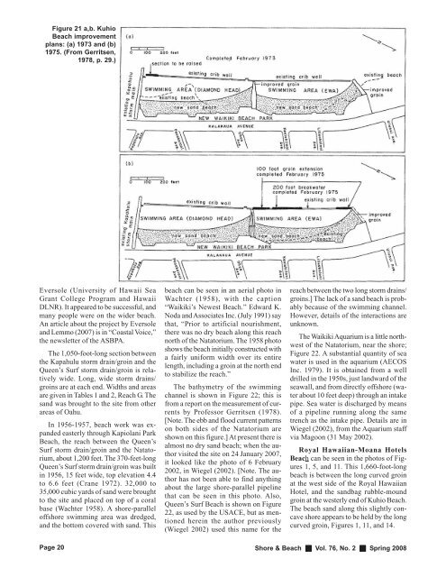
Figure 21 a,b. Kuhio<br />
<strong>Beach</strong> improvement<br />
plans: (a) 1973 and (b)<br />
1975. (From Gerr<strong>its</strong>en,<br />
1978, p. 29.)<br />
Eversole (University <strong>of</strong> <strong>Hawaii</strong> Sea<br />
Grant College Program and <strong>Hawaii</strong><br />
DLNR). It appeared to be successful, and<br />
many people were on the wider beach.<br />
An article about the project by Eversole<br />
and Lemmo (2007) is in “Coastal Voice,”<br />
the newsletter <strong>of</strong> the ASBPA.<br />
The 1,050-foot-long section between<br />
the Kapahulu storm drain/groin and the<br />
Queen’s Surf storm drain/groin is relatively<br />
wide. Long, wide storm drains/<br />
groins are at each end. Widths and areas<br />
are given in Tables 1 and 2, Reach G. The<br />
sand was brought to the site from other<br />
areas <strong>of</strong> Oahu.<br />
In 1956-1957, beach work was expanded<br />
easterly through Kapiolani Park<br />
<strong>Beach</strong>, the reach between the Queen’s<br />
Surf storm drain/groin and the Natatorium,<br />
about 1,200 feet. The 370-feet-long<br />
Queen’s Surf storm drain/groin was built<br />
in 1956, 15 feet wide, top elevation 4.4<br />
to 6.6 feet (Crane 1972). 32,000 to<br />
35,000 cubic yards <strong>of</strong> sand were brought<br />
to the site and placed on top <strong>of</strong> a coral<br />
base (Wachter 1958). A shore-parallel<br />
<strong>of</strong>fshore swimming area was dredged,<br />
and the bottom covered with sand. This<br />
Page 20<br />
beach can be seen in an aerial photo in<br />
Wachter (1958), with the caption<br />
“<strong>Waikiki</strong>’s Newest <strong>Beach</strong>.” Edward K.<br />
Noda and Associates Inc. (July 1991) say<br />
that, “Prior to artificial nourishment,<br />
there was no dry beach along this reach<br />
north <strong>of</strong> the Natatorium. The 1958 photo<br />
shows the beach initially constructed with<br />
a fairly uniform width over <strong>its</strong> entire<br />
length, including a groin at the north end<br />
to stabilize the reach.”<br />
The bathymetry <strong>of</strong> the swimming<br />
channel is shown in Figure 22; this is<br />
from a report on the measurement <strong>of</strong> currents<br />
by Pr<strong>of</strong>essor Gerr<strong>its</strong>en (1978).<br />
[Note. The ebb and flood current patterns<br />
on both sides <strong>of</strong> the Natatorium are<br />
shown on this figure.] At present there is<br />
almost no dry sand beach; when the author<br />
visited the site on 24 January 2007,<br />
it looked like the photo <strong>of</strong> 6 February<br />
2002, in Wiegel (2002). [Note. The author<br />
has not been able to find anything<br />
about the large shore-parallel pipeline<br />
that can be seen in this photo. Also,<br />
Queen’s Surf <strong>Beach</strong> is shown on Figure<br />
22, as used by the USACE, but as mentioned<br />
herein the author previously<br />
(Wiegel 2002) used this name for the<br />
reach between the two long storm drains/<br />
groins.] The lack <strong>of</strong> a sand beach is probably<br />
because <strong>of</strong> the swimming channel.<br />
However, details <strong>of</strong> the interactions are<br />
unknown.<br />
The <strong>Waikiki</strong> Aquarium is a little northwest<br />
<strong>of</strong> the Natatorium, near the shore;<br />
Figure 22. A substantial quantity <strong>of</strong> sea<br />
water is used in the aquarium (AECOS<br />
Inc. 1979). It is obtained from a well<br />
drilled in the 1950s, just landward <strong>of</strong> the<br />
seawall, and from directly <strong>of</strong>fshore (water<br />
about 10 feet deep) through an intake<br />
pipe. Sea water is discharged by means<br />
<strong>of</strong> a pipeline running along the same<br />
trench as the intake pipe. Details are in<br />
Wiegel (2002), from the Aquarium staff<br />
via Magoon (31 May 2002).<br />
Royal <strong>Hawaii</strong>an-Moana Hotels<br />
<strong>Beach</strong> can be seen in the photos <strong>of</strong> Figures<br />
1, 5, and 11. This 1,660-foot-long<br />
beach is between the long curved groin<br />
at the west side <strong>of</strong> the Royal <strong>Hawaii</strong>an<br />
Hotel, and the sandbag rubble-mound<br />
groin at the westerly end <strong>of</strong> Kuhio <strong>Beach</strong>.<br />
The beach sand along this slightly concave<br />
shore appears to be held by the long<br />
curved groin, Figures 1, 11, and 14.<br />
Shore & <strong>Beach</strong> Vol. 76, No. 2 Spring 2008