Waikiki Beach: History of its transformation - Hawaii.gov
Waikiki Beach: History of its transformation - Hawaii.gov
Waikiki Beach: History of its transformation - Hawaii.gov

Create successful ePaper yourself
Turn your PDF publications into a flip-book with our unique Google optimized e-Paper software.
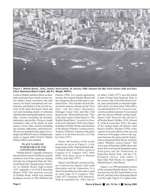
Figure 1. <strong>Waikiki</strong> <strong>Beach</strong>,, Oahu, <strong>Hawaii</strong>. Aerial photo, 24 January 1998; between Ala Wai Yacht Harbor (left) and Sans<br />
Souci (Kaimana) <strong>Beach</strong> (right). (By R.L. Wiegel, #8878.)<br />
events at <strong>Waikiki</strong> and their effects on shore<br />
and coastal processes; beach erosion control<br />
studies; beach restoration and sand<br />
sources for beach nourishment and construction;<br />
and features <strong>of</strong> the several sections<br />
<strong>of</strong> the shore and beach; beach and<br />
reef sand (including details <strong>of</strong> carbonate<br />
sand formation and <strong>transformation</strong>), waves,<br />
tides, currents (including rip currents),<br />
bathymetry and pr<strong>of</strong>iles. Owing to length<br />
limitations, many <strong>of</strong> the details on sand<br />
sources, waves, tides, currents (including<br />
rip currents), bathymetry, and beach pr<strong>of</strong>iles<br />
are not included in this paper. For example,<br />
the SHOALS survey <strong>of</strong> bathymetry<br />
made in August 2000 (USACE Mobile<br />
District 2002) is not included.<br />
PLACE NAMES OF<br />
WAIKIKI BEACH AND<br />
CONTIGUOUS SHORE<br />
“<strong>Waikiki</strong> <strong>Beach</strong>” originally referred to<br />
the beach between Fort DeRussy and the<br />
northwest end <strong>of</strong> the causeway leading<br />
from the city to Kapiolani Park, the “Diamond<br />
Head side” (Engineering Committee<br />
on <strong>Waikiki</strong> <strong>Beach</strong> Improvement<br />
1927; Appendix 1 <strong>of</strong> USACE Honolulu<br />
District 1950). This causeway was part<br />
<strong>of</strong> <strong>Waikiki</strong> Road, which was renamed<br />
Kalakaua Avenue in 1905 (Hibbard and<br />
Page 4<br />
Franzen 1986). For coastal engineering<br />
reasons, the original <strong>Waikiki</strong> <strong>Beach</strong> and<br />
the contiguous shore at both sides is considered<br />
here. This includes Kewalo Basin<br />
and <strong>its</strong> entrance channel on the “Ewa<br />
side,” and San Souci (Kaimana),<br />
Outrigger Canoe Club, and Elks Club<br />
<strong>Beach</strong> at the “Diamond Head side.” This<br />
is the same region written about in “The<br />
<strong>Waikiki</strong> <strong>Beach</strong> Story,” an article in Shore<br />
& <strong>Beach</strong> by Wachter (1958), then Superintendent<br />
<strong>of</strong> Public Works and chairman<br />
<strong>of</strong> the Board <strong>of</strong> Harbor Commissioners,<br />
Territory <strong>of</strong> <strong>Hawaii</strong>. A history <strong>of</strong> the place<br />
names is in the book <strong>Beach</strong>es <strong>of</strong> O’ahu<br />
by Clark (1977).<br />
Names and locations <strong>of</strong> the several<br />
sections are given in Figure 4. A few<br />
beach names at the “Diamond Head side”<br />
<strong>of</strong> <strong>Waikiki</strong> <strong>Beach</strong> in USACE reports to<br />
Congress (U.S. Congress 1953; 1963)<br />
differ from those given in Wachter<br />
(1958), and Clark (1977).<br />
Queen’s Surf <strong>Beach</strong> is located on Figure<br />
4 between the Queen’s Surf storm<br />
drain/groin and the Natatorium. It is<br />
shown in parentheses,as the name is used<br />
on some maps (U.S. Congress 1965;<br />
Clark 1977; Gerr<strong>its</strong>en 1978; Edward K.<br />
Noda & Associates Inc. 1991), but not<br />
on others. Clark (1977) says this beach<br />
is part <strong>of</strong> Kapi’olani Regional Park, at<br />
the western side <strong>of</strong> the Park <strong>Beach</strong> Center,<br />
and is named after a restaurant-nightclub<br />
which was there from 1946 until it<br />
was demolished in 1971; it was in a converted<br />
oceanfront mansion. It was named<br />
after the famous <strong>Waikiki</strong> surfing break,<br />
Queen’s Surf. However, this surf site is<br />
<strong>of</strong>f Kuhio <strong>Beach</strong> (Walker 1974; Edward<br />
K. Noda & Associates 1991); the name<br />
<strong>of</strong> the surfing break <strong>of</strong>f Queen’s Surf<br />
<strong>Beach</strong> is Publics. Wachter (1958), in the<br />
caption <strong>of</strong> an aerial photo <strong>of</strong> the site and<br />
in the text <strong>of</strong> his paper, refers to the segment<br />
between the groin and the Natatorium<br />
as Kapiolani Park <strong>Beach</strong>, which he<br />
called “<strong>Waikiki</strong>’s newest beach.” The<br />
AAA map <strong>of</strong> Honolulu (2006) shows the<br />
entire shore between the Kapahulu storm<br />
drain/groin and the Natatorium as<br />
Kapiolani <strong>Beach</strong> Park, and the U.S.<br />
Geolgical Survey map labels it<br />
Kapi’olani Park <strong>Beach</strong>; no segment is<br />
labeled Queen’s Surf <strong>Beach</strong>.<br />
Figure 1 is a 1998 aerial photo <strong>of</strong> most<br />
<strong>of</strong> the extended <strong>Waikiki</strong> <strong>Beach</strong>. The section<br />
between Ala Wai Yacht Harbor is on<br />
the left, and Sans Souci (Kaimana) <strong>Beach</strong><br />
is on the right. Figure 5 is a photo look-<br />
Shore & <strong>Beach</strong> Vol. 76, No. 2 Spring 2008