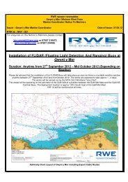
F. Geology & Hydrology ( PDF | 31.0 MB ) - RWE.com
F. Geology & Hydrology ( PDF | 31.0 MB ) - RWE.com
F. Geology & Hydrology ( PDF | 31.0 MB ) - RWE.com

Create successful ePaper yourself
Turn your PDF publications into a flip-book with our unique Google optimized e-Paper software.
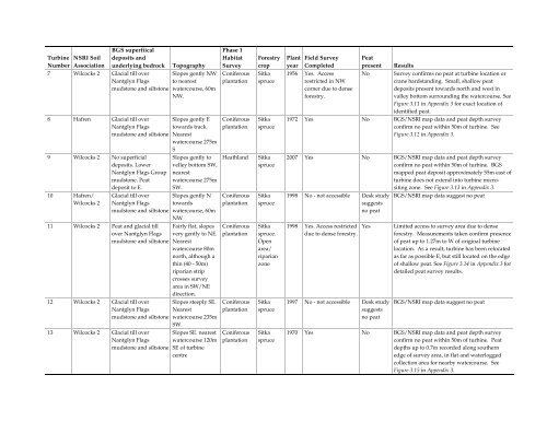
Turbine NSRI Soil<br />
BGS superfiical<br />
deposits and<br />
Number Association underlying bedrock Topography<br />
7 Wilcocks 2 Glacial till over Slopes gently NW<br />
Nantglyn Flags to nearest<br />
mudstone and siltstone watercourse, 60m<br />
NW.<br />
8 Hafren Glacial till over<br />
Nantglyn Flags<br />
mudstone and siltstone<br />
9 Wilcocks 2 No superficial<br />
deposits. Lower<br />
Nantglyn Flags Group<br />
mudstone. Peat<br />
deposit to E.<br />
10 Hafren/<br />
Wilcocks 2<br />
Glacial till over<br />
Nantglyn Flags<br />
mudstone and siltstone<br />
11 Wilcocks 2 Peat and glacial till<br />
over Nantglyn Flags<br />
mudstone and siltstone<br />
12 Wilcocks 2 Glacial till over<br />
Nantglyn Flags<br />
mudstone and siltstone<br />
13 Wilcocks 2 Glacial till over<br />
Nantglyn Flags<br />
mudstone and siltstone<br />
Slopes gently E<br />
towards track.<br />
Nearest<br />
watercourse 275m<br />
S<br />
Slopes gently to<br />
velley bottom SW,<br />
nearest<br />
watercourse 275m<br />
SW.<br />
Slopes gently N<br />
towards<br />
watercourse, 60m<br />
NW<br />
Fairly flat, slopes<br />
very gently to NE.<br />
Nearest<br />
watercourse 80m<br />
north, although a<br />
thin (40 - 50m)<br />
riparian strip<br />
crosses survey<br />
area in SW/NE<br />
direction.<br />
Slopes steeply SE.<br />
Nearest<br />
watercourse 235m<br />
SW.<br />
Slopes SE. nearest<br />
watercourse 120m<br />
SE of turbine<br />
centre<br />
Phase 1<br />
Habitat<br />
Survey<br />
Coniferous<br />
plantation<br />
Coniferous<br />
plantation<br />
Forestry<br />
crop<br />
Sitka<br />
spruce<br />
Sitka<br />
spruce<br />
Heathland Sitka<br />
spruce<br />
Coniferous<br />
plantation<br />
Coniferous<br />
plantation<br />
Coniferous<br />
plantation<br />
Coniferous<br />
plantation<br />
Sitka<br />
spruce<br />
Sitka<br />
spruce.<br />
Open<br />
area/<br />
riparian<br />
zone<br />
Sitka<br />
spruce<br />
Sitka<br />
spruce<br />
Plant Field Survey Peat<br />
year Completed present Results<br />
1956 Yes. Access<br />
No Survey confirms no peat at turbine location or<br />
restricted in NW<br />
crane hardstanding. Small, shallow peat<br />
corner due to dense<br />
deposits present towards north and west in<br />
forestry.<br />
valley bottom surrounding the watercourse. See<br />
Figure 3.11 in Appendix 3 for exact location of<br />
identified peat.<br />
1972 Yes No BGS/NSRI map data and peat depth survey<br />
confirm no peat within 50m of turbine. See<br />
Figure 3.12 in Appendix 3.<br />
2007 Yes No BGS/NSRI map data and peat depth survey<br />
confirm no peat within 50m of turbine. BGS<br />
mapped peat deposit approximately 55m east of<br />
turbine does not extend into turbine micrositing<br />
zone. See Figure 3.13 in Appendix 3.<br />
1998 No - not accessible Desk study<br />
suggests<br />
no peat<br />
BGS/NSRI map data suggest no peat<br />
1998 Yes. Access restricted<br />
due to dense forestry.<br />
1997 No - not accessible Desk study<br />
suggests<br />
no peat<br />
Yes Limited access to survey area due to dense<br />
forestry. Measurements taken confirm presence<br />
of peat up to 1.27m to W of original turbine<br />
location. As a result, turbine has been relocated<br />
as far as possible E, but still located on the edge<br />
of shallow peat. See Figure 3.14 in Appendix 3 for<br />
detailed peat survey results.<br />
BGS/NSRI map data suggest no peat<br />
1970 Yes No BGS/NSRI map data and peat depth survey<br />
confirm no peat within 50m of turbine. Peat<br />
depths up to 0.7m recorded along southern<br />
edge of survey area, in flat and waterlogged<br />
collection area for nearby watercourse. See<br />
Figure 3.15 in Appendix 3.